They have moved one of the Ramsdis Floaters back onto it. Has a tight low level circulation for sure, shows up beautifully on here.......
http://www.cira.colostate.edu/ramm/rmsd ... PICAL.html
ATL: TROPICAL LOW ex-FRED (ex-07L)
Moderator: S2k Moderators
-
Dean4Storms
- S2K Supporter

- Posts: 6358
- Age: 63
- Joined: Sun Aug 31, 2003 1:01 pm
- Location: Miramar Bch. FL
-
Aric Dunn
- Category 5

- Posts: 21238
- Age: 43
- Joined: Sun Sep 19, 2004 9:58 pm
- Location: Ready for the Chase.
- Contact:
Re:
Evil Jeremy wrote:..... Fred's still there lol?????? Fred is a fighter lol. At this point though, if this system was to reform, would it still be called Fred? It has spouted a new circulation, the old one died.
same circ as before no new one .
0 likes
-
Dean4Storms
- S2K Supporter
- Posts: 6358
- Age: 63
- Joined: Sun Aug 31, 2003 1:01 pm
- Location: Miramar Bch. FL
-
expat2carib

- S2K Supporter
- Posts: 458
- Joined: Tue Jul 22, 2008 1:44 pm
- Location: Sint Maarten

-
ozonepete
- Professional-Met

- Posts: 4743
- Joined: Mon Sep 07, 2009 3:23 pm
- Location: From Ozone Park, NYC / Now in Brooklyn, NY
Re:
Evil Jeremy wrote:..... Fred's still there lol?????? Fred is a fighter lol. At this point though, if this system was to reform, would it still be called Fred? It has spouted a new circulation, the old one died.
We were talking about this a little bit before. The NHC referred to this LLC as a part of the remnants of Fred at 8PM:
A 1015 MB SURFACE LOW ...REMNANT OF FRED...IS CENTERED NEAR 25N62W AND EXTENDS A SURFACE TROUGH FROM 22N62W THROUGH THE LOW TO 27N61W. SURFACE CONVERGENCE NEAR THE LOW AND TROUGH ARE SUPPORTING ISOLATED SHOWERS FROM 20N-26N BETWEEN 59W-65W.
So I would think that if it reformed they would...?
P.S. I still don't think it will make it, but it's amazing how hard it keeps going.
0 likes
-
IvanSurvivor
- Tropical Storm

- Posts: 152
- Joined: Wed Aug 20, 2008 12:12 am
- Location: Pensacola Florida (Warrington)
Re:
Dean4Storms wrote:And if you extrapolate the synoptics from the NAM it makes sense that it would cross FL over into the GOM maybe just north of Tampa or thereabouts.
And then go...?
0 likes
-
MGC

- S2K Supporter
- Posts: 5940
- Joined: Sun Mar 23, 2003 9:05 pm
- Location: Pass Christian MS, or what is left.
Re: ATL: TROPICAL DEPRESSION FRED (07L)
Quite surprised that Fred has held together considering the lack of convection near the center. Still have to watch it because you never know what the tropics will do.....MGC
0 likes

Re:
HURAKAN wrote:
Still there
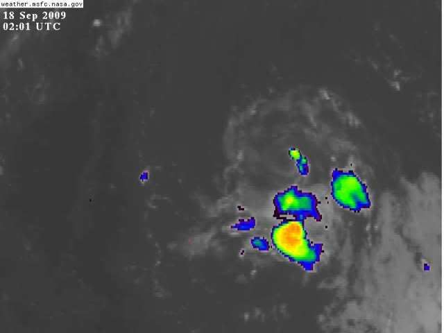
Looking at that image it looks like it's still has some shear that is blowing off the convection to the south. The shear just won't let up. I can't believe it's still going with such hostile conditions.
0 likes


Re: ATL: TROPICAL DEPRESSION FRED (07L)
Our little friend Fred is still hanging on this morning. Pretty well-developed LLC. Thunderstorms still being blown to the south by strong N-NE wind shear. Wind shear slackens some by 70W and is really light in the Bahamas so I think we need to still watch it. Steering winds bring the system due west into FL in 3-4 days.
http://www.ssd.noaa.gov/goes/east/watl/loop-avn.html
http://www.ssd.noaa.gov/goes/east/watl/loop-avn.html
0 likes

Re: ATL: TROPICAL DEPRESSION FRED (07L)
Be interesting if the energy from the trough along 75W gets pulled into the circulation of ex-Fred, The NAM was showing this the last several runs.
0 likes

-
hurricanetrack

- HurricaneTrack.com
- Posts: 1781
- Joined: Tue Dec 02, 2003 10:46 pm
- Location: Wilmington, NC
- Contact:
If this makes it to land looking anything like it does now, or better, I think I will have to be there just to see what Fred looks like in person. It would be one of the weakest systems I have ever intercepted but my goodness, it was once a cat-3 hurricane and traveled all this way. Just might have to consider going to Florida or where ever this thing ends up.
0 likes
-
Blown Away

- S2K Supporter
- Posts: 10253
- Joined: Wed May 26, 2004 6:17 am
Re: ATL: TROPICAL DEPRESSION FRED (07L)
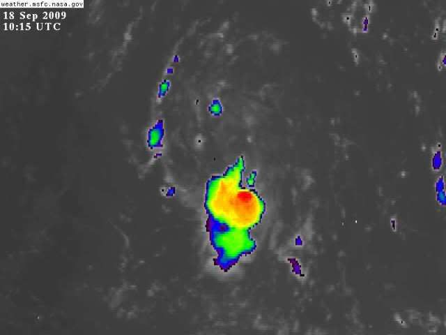
I see reds on the IR, the recent convection to the S of the circulation may be the beginning. It's near 67W which is nearly 800 miles E of Florida, this could easily develope into a TS before coming to or near Florida. I welcome a nice 50-60 mph TS. 
0 likes
-
Shewtinstar
- Tropical Low

- Posts: 32
- Joined: Wed Aug 26, 2009 10:01 am
Re:
hurricanetrack wrote:If this makes it to land looking anything like it does now, or better, I think I will have to be there just to see what Fred looks like in person. It would be one of the weakest systems I have ever intercepted but my goodness, it was once a cat-3 hurricane and traveled all this way. Just might have to consider going to Florida or where ever this thing ends up.
I am in Jacksonville, if it heads this way bunk out at my house.
What are the chances for rapid intesification?
0 likes
-
Blown Away
- S2K Supporter
- Posts: 10253
- Joined: Wed May 26, 2004 6:17 am
Re: ATL: TROPICAL DEPRESSION FRED (07L)
Shewtinstar wrote:I am in Jacksonville, if it heads this way bunk out at my house.
What are the chances for rapid intesification?
0 likes
-
Blown Away
- S2K Supporter
- Posts: 10253
- Joined: Wed May 26, 2004 6:17 am
Re: ATL: TROPICAL DEPRESSION FRED (07L)
Looks like the shear has eased, I don't see the cloud tops being blown off. There is still dry air around this system but that air is slowly moistening. Can this circulation maintain the convection, let's see if the recent ball of convection along the south side of the circulation can continue to build. I think this bears watching!
WV Loop:
http://www.ssd.noaa.gov/goes/east/tatl/loop-wv.html
WV Loop:
http://www.ssd.noaa.gov/goes/east/tatl/loop-wv.html
0 likes
-
HURAKAN

- Professional-Met
- Posts: 46084
- Age: 39
- Joined: Thu May 20, 2004 4:34 pm
- Location: Key West, FL
- Contact:
488
ABNT20 KNHC 181131
TWOAT
TROPICAL WEATHER OUTLOOK
NWS TPC/NATIONAL HURRICANE CENTER MIAMI FL
800 AM EDT FRI SEP 18 2009
FOR THE NORTH ATLANTIC...CARIBBEAN SEA AND THE GULF OF MEXICO...
THE SMALL LOW PRESSURE AREA ASSOCIATED WITH THE REMNANTS OF FRED IS
CENTERED ABOUT 475 MILES SOUTH OF BERMUDA. THIS SYSTEM IS MOVING
WESTWARD AT 10 TO 15 MPH WITH MINIMAL SHOWER ACTIVITY. UPPER-LEVEL
WINDS ARE NOT CURRENTLY FAVORABLE FOR SIGNIFICANT DEVELOPMENT.
THERE IS A LOW CHANCE...LESS THAN 30 PERCENT...OF THIS SYSTEM
BECOMING A TROPICAL CYCLONE DURING THE NEXT 48 HOURS.
A BROAD AREA OF LOW PRESSURE CENTERED ABOUT 950 MILES WEST OF THE
SOUTHERNMOST CAPE VERDE ISLANDS CONTINUES TO SHOW SIGNS OF
ORGANIZATION. WHILE UPPER-LEVEL WINDS ARE ONLY MARGINALLY
FAVORABLE...SOME SLOW DEVELOPMENT OF THIS SYSTEM IS POSSIBLE AS IT
MOVES WEST-NORTHWESTWARD AT AROUND 10 MPH OVER THE NEXT COUPLE OF
DAYS. THERE IS A MEDIUM CHANCE...30 TO 50 PERCENT...OF THIS SYSTEM
BECOMING A TROPICAL CYCLONE DURING THE NEXT 48 HOURS.
ELSEWHERE...TROPICAL CYCLONE FORMATION IS NOT EXPECTED DURING THE
NEXT 48 HOURS.
$$
FORECASTER BRENNAN
0 likes
Who is online
Users browsing this forum: No registered users and 8 guests