ATL: TROPICAL LOW ex-FRED (ex-07L)

Moderator: S2k Moderators

Message
Author
User avatar
HURAKAN
Professional-Met
Professional-Met
Posts: 46086
Age: 38
Joined: Thu May 20, 2004 4:34 pm
Location: Key West, FL
Contact:

#1121 Postby HURAKAN » Fri Sep 18, 2009 6:51 am

Image

Latest
0 likes   

User avatar
Blown Away
S2K Supporter
S2K Supporter
Posts: 10146
Joined: Wed May 26, 2004 6:17 am

Re: ATL: TROPICAL DEPRESSION FRED (07L)

#1122 Postby Blown Away » Fri Sep 18, 2009 7:06 am

:uarrow: IMO, the LLC looks pretty good. Local mets talking about this wave moving into Florida late weekend, no hints or mention of any development, that may change!

Hurakan, how is this not being talked about more?? Looks good this morning, where are all my Florida homies?? :D
0 likes   

User avatar
Evil Jeremy
S2K Supporter
S2K Supporter
Posts: 5463
Age: 32
Joined: Mon Apr 10, 2006 2:10 pm
Location: Los Angeles, CA

Re: ATL: TROPICAL DEPRESSION FRED (07L)

#1123 Postby Evil Jeremy » Fri Sep 18, 2009 7:17 am

Blown_away wrote:Looks good this morning, where are all my Florida homies?? :D

Sleeping lol.

This looks interesting, but I don't think it will reform. Conditions are just to hostile overall. Also, if it did reform, I would have to eat a lot of crow lol. Last week I told a lot of people not to worry about Fred, it would not come anywhere near us, it was on its way on re curving out into the ocean. I said Fred was going to be a non event for the US. This was when the models were showing it recurving and everyone thought it was going to dissipate anyways. If this reforms, I have a lot of explaining to do lol.
0 likes   

User avatar
HURAKAN
Professional-Met
Professional-Met
Posts: 46086
Age: 38
Joined: Thu May 20, 2004 4:34 pm
Location: Key West, FL
Contact:

#1124 Postby HURAKAN » Fri Sep 18, 2009 7:20 am

AL, 07, 2009091812, , BEST, 0, 253N, 660W, 25, 1013, LO

They're still keeping an eye on it!
0 likes   

User avatar
HURAKAN
Professional-Met
Professional-Met
Posts: 46086
Age: 38
Joined: Thu May 20, 2004 4:34 pm
Location: Key West, FL
Contact:

Re: ATL: TROPICAL DEPRESSION FRED (07L) - Computer Models

#1125 Postby HURAKAN » Fri Sep 18, 2009 7:21 am

665
WHXX01 KWBC 181211
CHGHUR
TROPICAL CYCLONE GUIDANCE MESSAGE
NWS TPC/NATIONAL HURRICANE CENTER MIAMI FL
1211 UTC FRI SEP 18 2009

DISCLAIMER...NUMERICAL MODELS ARE SUBJECT TO LARGE ERRORS.
PLEASE REFER TO NHC OFFICIAL FORECASTS FOR TROPICAL CYCLONE
AND SUBTROPICAL CYCLONE INFORMATION.

ATLANTIC OBJECTIVE AIDS FOR

DISTURBANCE FRED (AL072009) 20090918 1200 UTC

...00 HRS... ...12 HRS... ...24 HRS. .. ...36 HRS...
090918 1200 090919 0000 090919 1200 090920 0000

LAT LON LAT LON LAT LON LAT LON
BAMS 25.3N 66.0W 26.1N 67.8W 26.9N 69.6W 27.3N 71.0W
BAMD 25.3N 66.0W 25.5N 67.9W 25.7N 69.4W 25.7N 70.6W
BAMM 25.3N 66.0W 25.8N 67.8W 26.3N 69.3W 26.5N 70.4W
LBAR 25.3N 66.0W 25.9N 68.1W 26.6N 69.7W 27.1N 71.1W
SHIP 25KTS 28KTS 33KTS 39KTS
DSHP 25KTS 28KTS 33KTS 39KTS

...48 HRS... ...72 HRS... ...96 HRS. .. ..120 HRS...
090920 1200 090921 1200 090922 1200 090923 1200

LAT LON LAT LON LAT LON LAT LON
BAMS 27.5N 73.1W 28.4N 77.3W 29.8N 81.0W 32.1N 83.9W
BAMD 25.8N 71.8W 26.2N 73.9W 26.6N 76.5W 27.4N 79.6W
BAMM 26.7N 71.8W 27.3N 74.6W 28.1N 77.6W 29.7N 80.6W
LBAR 27.1N 72.4W 26.6N 75.0W 26.5N 77.8W 26.8N 81.3W
SHIP 44KTS 50KTS 55KTS 58KTS
DSHP 44KTS 50KTS 55KTS 58KTS

...INITIAL CONDITIONS...
LATCUR = 25.3N LONCUR = 66.0W DIRCUR = 280DEG SPDCUR = 13KT
LATM12 = 24.9N LONM12 = 63.3W DIRM12 = 281DEG SPDM12 = 13KT
LATM24 = 24.2N LONM24 = 59.8W
WNDCUR = 25KT RMAXWD = 15NM WNDM12 = 25KT
CENPRS = 1013MB OUTPRS = 1015MB OUTRAD = 150NM SDEPTH = S
RD34NE = 0NM RD34SE = 0NM RD34SW = 0NM RD34NW = 0NM

$$
NNNN

0 likes   

User avatar
wxman57
Moderator-Pro Met
Moderator-Pro Met
Posts: 22979
Age: 67
Joined: Sat Jun 21, 2003 8:06 pm
Location: Houston, TX (southwest)

Re: ATL: TROPICAL DEPRESSION FRED (07L)

#1126 Postby wxman57 » Fri Sep 18, 2009 7:21 am

This thing is like a cockroach.
0 likes   

User avatar
HURAKAN
Professional-Met
Professional-Met
Posts: 46086
Age: 38
Joined: Thu May 20, 2004 4:34 pm
Location: Key West, FL
Contact:

Re: ATL: TROPICAL DEPRESSION FRED (07L)

#1127 Postby HURAKAN » Fri Sep 18, 2009 7:22 am

wxman57 wrote:This thing is like a cockroach.


Anyone would like to throw a nuclear bomb at it? Oh, sorry, they also survive nuclear bombs!!!! :lol:
0 likes   

User avatar
HurricaneBelle
S2K Supporter
S2K Supporter
Posts: 1179
Joined: Sun Aug 27, 2006 6:12 pm
Location: Clearwater, FL

Re:

#1128 Postby HurricaneBelle » Fri Sep 18, 2009 7:40 am

HURAKAN wrote:Image

Latest


Fred has a ZZ Top-style beard.
0 likes   

User avatar
alan1961
Category 2
Category 2
Posts: 771
Joined: Mon Mar 20, 2006 11:58 am
Location: Derby, Derbyshire, England
Contact:

Re: Re:

#1129 Postby alan1961 » Fri Sep 18, 2009 7:55 am

HurricaneBelle wrote:
HURAKAN wrote:Image

Latest


Fred has a ZZ Top-style beard.


And he's been given plenty of lovin!, come on Hurakan give us a Billy Gibbons :lol:
Last edited by alan1961 on Fri Sep 18, 2009 7:58 am, edited 1 time in total.
0 likes   

User avatar
HURAKAN
Professional-Met
Professional-Met
Posts: 46086
Age: 38
Joined: Thu May 20, 2004 4:34 pm
Location: Key West, FL
Contact:

#1130 Postby HURAKAN » Fri Sep 18, 2009 7:58 am

Image

A+ for trying!
0 likes   

User avatar
HURAKAN
Professional-Met
Professional-Met
Posts: 46086
Age: 38
Joined: Thu May 20, 2004 4:34 pm
Location: Key West, FL
Contact:

#1131 Postby HURAKAN » Fri Sep 18, 2009 8:02 am

Image

Yes, he's back! (As a disturbance)
0 likes   

Dean4Storms
S2K Supporter
S2K Supporter
Posts: 6358
Age: 62
Joined: Sun Aug 31, 2003 1:01 pm
Location: Miramar Bch. FL

#1132 Postby Dean4Storms » Fri Sep 18, 2009 8:12 am

All we are missing here is some persistent convection and this could deepen fairly rapidly back into a TC with it already an impressive circulation to work with, would not take much IMO!
0 likes   

User avatar
HURAKAN
Professional-Met
Professional-Met
Posts: 46086
Age: 38
Joined: Thu May 20, 2004 4:34 pm
Location: Key West, FL
Contact:

#1133 Postby HURAKAN » Fri Sep 18, 2009 8:30 am

Image

Image

Latest
0 likes   

User avatar
BigA
Professional-Met
Professional-Met
Posts: 1317
Joined: Sun Jul 24, 2005 10:56 pm

Re: ATL: TROPICAL LOW ex-FRED (ex-07L)

#1134 Postby BigA » Fri Sep 18, 2009 8:34 am

Dean4Storms wrote:All we are missing here is some persistent convection and this could deepen fairly rapidly back into a TC with it already an impressive circulation to work with, would not take much IMO!


Agreed. Fred ¨looks¨a lot like a 40 to 50 mph tropical storm right now. I say looks because 1) I am not sure how well defined the surface circulation is, and 2) tropical cyclones must have persistence. If said convection can stay as it is or improve, we may see an upgrade in the future. The system is under some northerly shear right now, but it looks like a few degrees westward said shear will abate.
0 likes   

User avatar
Blown Away
S2K Supporter
S2K Supporter
Posts: 10146
Joined: Wed May 26, 2004 6:17 am

Re: ATL: TROPICAL DEPRESSION FRED (07L) - Computer Models

#1135 Postby Blown Away » Fri Sep 18, 2009 8:38 am

:uarrow: I read the stronger it gets more W it goes and almost a hurricane. :eek: :larrow: :lol:
0 likes   

User avatar
blp
Category 5
Category 5
Posts: 2840
Age: 46
Joined: Thu Sep 09, 2004 7:51 pm
Location: Miami, FL
Contact:

Re: ATL: TROPICAL LOW ex-FRED (ex-07L)

#1136 Postby blp » Fri Sep 18, 2009 8:43 am

Convection working its way over the center. If the shear lays off a little watch out. Nice low level rotation.

http://hadar.cira.colostate.edu/ramsdis ... at2_0.html
0 likes   

User avatar
Macrocane
Category 5
Category 5
Posts: 4218
Age: 36
Joined: Sun May 24, 2009 5:35 pm
Location: El Salvador

Re: ATL: TROPICAL LOW ex-FRED (ex-07L)

#1137 Postby Macrocane » Fri Sep 18, 2009 8:51 am

Very nice burst of convection over the center, it looks better than Danny IMO, let's see if convection this time persist or poofs as it has been the case with the other bursts.
0 likes   

Steve H.
Category 5
Category 5
Posts: 2146
Joined: Sat Oct 19, 2002 9:06 am
Location: Palm Bay, Florida

Re: ATL: TROPICAL LOW ex-FRED (ex-07L) - Computer Models

#1138 Postby Steve H. » Fri Sep 18, 2009 8:56 am

If the shear drops off and the environment moistens, we could have TS Fred again. But let's not jump the gun yet. Fred is itsy bitsy right now, and it wouldn't take much shear to strip him. If he does re-gain TS staus, we will have to see if the ridging on the eastern seaboard builds in. If not,, he could turn towards the GA/SC. If the ridging does build in, somewhere on the FL peninsula. Now will he be a cyclone or a thunderstorm?
0 likes   

Steve H.
Category 5
Category 5
Posts: 2146
Joined: Sat Oct 19, 2002 9:06 am
Location: Palm Bay, Florida

Re: ATL: TROPICAL LOW ex-FRED (ex-07L)

#1139 Postby Steve H. » Fri Sep 18, 2009 9:04 am

Still some decent shear from the NE probably coming from high pressure near the mid_Atlantic, noticable on the 16:45 visible. This must drop off if Fred is to regain any strength.
0 likes   

User avatar
Blown Away
S2K Supporter
S2K Supporter
Posts: 10146
Joined: Wed May 26, 2004 6:17 am

Re: ATL: TROPICAL LOW ex-FRED (ex-07L)

#1140 Postby Blown Away » Fri Sep 18, 2009 9:08 am

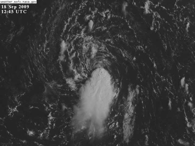
Steve H. wrote:Still some decent shear from the NE probably coming from high pressure near the mid_Atlantic, noticable on the 16:45 visible. This must drop off if Fred is to regain any strength.


Since about 3:45am the convection has been building w/o being sheared off and now the convection is building over the LLC. If this trend continues I see code orange or even red at 2pm.
0 likes   


Return to “2009”

Who is online

Users browsing this forum: No registered users and 5 guests