ATL: TROPICAL LOW ex-FRED (ex-07L)
Moderator: S2k Moderators
-
ozonepete
- Professional-Met

- Posts: 4743
- Joined: Mon Sep 07, 2009 3:23 pm
- Location: From Ozone Park, NYC / Now in Brooklyn, NY
Re: ATL: TROPICAL LOW ex-FRED (ex-07L)
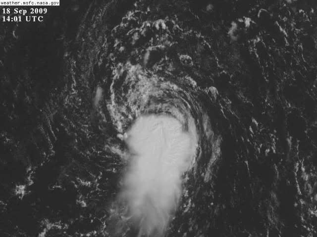
Holy Cow! That's really starting to look impressive. Sorry I can't post any images from this location. Somebody's gotta put up a 1km visible. That convection is really getting over the center. With shear really dropping off, this could intensify pretty quickly.
0 likes
-
Weatherboy1

- Category 5

- Posts: 1190
- Age: 50
- Joined: Mon Jul 05, 2004 1:50 pm
- Location: Jupiter/Sarasota, FL
-
HURAKAN

- Professional-Met
- Posts: 46084
- Age: 39
- Joined: Thu May 20, 2004 4:34 pm
- Location: Key West, FL
- Contact:
The remains of Hurricane Fred are still spinning away, near 25N 66W, about 900 miles east of Florida. Wind shear is 20 knots, which is marginal for development, and there is very dry air surrounding ex-Fred on all sides. None of the computer models develop ex-Fred, and it will have a tough time regenerating with so much dry air and wind shear. The remains of Fred should move over Florida Monday night or Tuesday morning.
Jeff Masters - http://www.wunderground.com/blog/JeffMa ... rynum=1323
Jeff Masters - http://www.wunderground.com/blog/JeffMa ... rynum=1323
0 likes
-
Aric Dunn
- Category 5
- Posts: 21238
- Age: 43
- Joined: Sun Sep 19, 2004 9:58 pm
- Location: Ready for the Chase.
- Contact:
yeah lots of convergence still but shear is still clearly a problem.. but it is forecast to weaken .. well actually it should move into low shear tomorrow.. the circulation is more expansive as well.. all we need a persistent area of convection even if it keeps getting blow off very similar to what has happened this morning.
0 likes
-
Evil Jeremy

- S2K Supporter

- Posts: 5463
- Age: 32
- Joined: Mon Apr 10, 2006 2:10 pm
- Location: Los Angeles, CA
The shear is still effecting Fred, but he, or what is left of him, is amazingly still there. What is the record for the longest amount of time between a system dieing and then regenerating? I would think that record goes to Ivan. I think it was from Sept 18 (5 years to the day, man time flies) to Sept 22 of 2004.
Last edited by Evil Jeremy on Fri Sep 18, 2009 9:32 am, edited 1 time in total.
0 likes
-
HURAKAN
- Professional-Met
- Posts: 46084
- Age: 39
- Joined: Thu May 20, 2004 4:34 pm
- Location: Key West, FL
- Contact:
MIAMI NWS:
LONG TERM...MONDAY THROUGH FRIDAY...LOOKS LIKE WHAT SEEM TO BE
THE REMNANTS OF "FRED" WILL MAKE IT TO SOUTH FLORIDA BY MONDAY AS
THE LEFTOVER WAVE MOVES AROUND THE BASE OF THE ATLANTIC RIDGE.
THIS WILL NOT ONLY RESULT IN AN INCREASE IN POPS ONCE AGAIN, BUT
ALSO IN AN INCREASE IN THE EAST FLOW WITH AN INCREASE RISK OF RIP
CURRENTS ALONG THE ATLANTIC BEACHES. EVEN THOUGH "FRED" REMNANTS
WILL EITHER MOVE WEST OF THE AREA OR DISSIPATE BY TUE, POPS ARE
EXPECTED TO REMAIN IN THE SCT CATEGORY THROUGH THE WHOLE WEEK AS
THE ATLANTIC RIDGE ONCE AGAIN BUILDS WEST ADVECTING MORE TROPICAL
MOISTURE FROM THE WESTERN ATLANTIC.
KEY WEST NWS:
EXTENDED...MONDAY THROUGH THURSDAY...A NEAR 1025-103 MB ANTICYCLONE
IS PROGGED TO REMAIN PARKED ACROSS THE WESTERN AND CENTRAL ATLANTIC
BETWEEN 35N AND 40N...KEEPING A MOIST GENTLE TO MODERATE EASTERLY
FLOW FROM THE SURFACE TO 20000 FEET ACROSS THE KEYS...WITH ABOVE
NORMAL PWAT NEAR 2.00 INCHES. IN ADDITION TO THAT...THE GFS AND
ECMWF HINT THAT THE REMNANTS OF FRED...NOW NEAR 65W...WILL BE MOVING
ACROSS KEYS LONGITUDE AS AN INVERTED TROUGH OR WEAK TROPICAL WAVE ON
MONDAY AND MONDAY NIGHT. BEHIND THIS SYSTEM...IT STILL REMAINS
ABNORMALLY MOIST WITH PWAT NEAR 2.00 INCHES...ALTHOUGH THERE ARE NO
DISCERNIBLE SYSTEMS UPSTREAM OF THAT...SO WILL KEEP SLIGHTLY ABOVE
NORMAL RAIN CHANCES OF 40 PERCENT IN PLACE. BUT IF NORTHING SHOWS UP
UPSTREAM OF THAT...MAY BE LOWERING RAIN CHANCES.
0 likes

Re: ATL: TROPICAL LOW ex-FRED (ex-07L)
The posts in this forum are NOT official forecast and should not be used as such. They are just the opinion of the poster and may or may not be backed by sound meteorological data. They are NOT endorsed by any professional institution or storm2k.org. For official information, please refer to the NHC and NWS products.
Dry air and shear are a problem now, but the convection over the center will help the LLC to survive and when it reaches more favorable conditions it could develop, plus conditions have improved a little and if it survived the more hostile conditions I don't see why it cannot survive the current ones.
Dry air and shear are a problem now, but the convection over the center will help the LLC to survive and when it reaches more favorable conditions it could develop, plus conditions have improved a little and if it survived the more hostile conditions I don't see why it cannot survive the current ones.
0 likes
-
Aric Dunn
- Category 5
- Posts: 21238
- Age: 43
- Joined: Sun Sep 19, 2004 9:58 pm
- Location: Ready for the Chase.
- Contact:
Re: ATL: TROPICAL LOW ex-FRED (ex-07L)
So heres the deal.. dry air can be over come if surface convergecne is high enough as we have seen already with convection. there is plenty of moisture at the surface its in the mid and upper levels that are the problems as that helps to collapse the convection once it forms. the image below is the location of the circ and its general direction. as you can see it is presently sitting under 20kts of northerly shear but is about to move into a much lower shear environment over the next 12 to 24 hrs. The upper high over the eastern Bahamas is forecast to stay put for the next 3 days which would allow fred to possibly find a decent environment. Its definitely going to interesting as the system is better looking that it has been since it degenerated.

The image below show the upper ridge in place over the eastern bahamas the system should arrive in that area ( circled in white) late tomorrow and sunday.

The image below show the upper ridge in place over the eastern bahamas the system should arrive in that area ( circled in white) late tomorrow and sunday.
Last edited by Aric Dunn on Fri Sep 18, 2009 9:45 am, edited 1 time in total.
0 likes
-
Weatherboy1
- Category 5
- Posts: 1190
- Age: 50
- Joined: Mon Jul 05, 2004 1:50 pm
- Location: Jupiter/Sarasota, FL
-
Nederlander
- S2K Supporter
- Posts: 1259
- Joined: Sat Jul 19, 2008 4:28 pm
- Location: Conroe, TX
Re: ATL: TROPICAL LOW ex-FRED (ex-07L)
I am not going start boiling my crow yet, but I will apologize to those I spoke at negatively in regards to this system. I honestly thought this thing was dead. what a little fighter. Still has a ways to go, but its definitely looking more impressive. So there it is, sorry for the naysaying with ex-Fred.
0 likes
-
Blown Away

- S2K Supporter
- Posts: 10253
- Joined: Wed May 26, 2004 6:17 am
Re: ATL: TROPICAL LOW ex-FRED (ex-07L)
All I see is convection that is beginning to wrap around the LLC and convection that has been building for almost 8 hours w/o being blown off.
Look at the wide view and this system gets more impressive frame by frame!
http://www.ssd.noaa.gov/goes/east/tatl/loop-avn.html
Look at the wide view and this system gets more impressive frame by frame!
http://www.ssd.noaa.gov/goes/east/tatl/loop-avn.html
0 likes
-
wxman57

- Moderator-Pro Met

- Posts: 23170
- Age: 68
- Joined: Sat Jun 21, 2003 8:06 pm
- Location: Houston, TX (southwest)
Re: ATL: TROPICAL LOW ex-FRED (ex-07L)
Just as fast as the convection built near the center, it's being sheared away to the south on the latest imagery.
0 likes

-
ozonepete
- Professional-Met
- Posts: 4743
- Joined: Mon Sep 07, 2009 3:23 pm
- Location: From Ozone Park, NYC / Now in Brooklyn, NY
Re: ATL: TROPICAL LOW ex-FRED (ex-07L)
wxman57 wrote:Just as fast as the convection built near the center, it's being sheared away to the south on the latest imagery.
Yeah, we can see that. But I'm more curious what you think will happen later today as it moves into a much lower shear environment of 10-15 knots and it could be even less. Also, I think Jeff Masters is really exagerrating the dry air by saying "very dry." It doesn't look that bad to me on the CIMSS mid-level WV. What say you? You have some pretty good software there mr. wxman57.
Last edited by ozonepete on Fri Sep 18, 2009 10:02 am, edited 1 time in total.
0 likes
-
Aric Dunn
- Category 5
- Posts: 21238
- Age: 43
- Joined: Sun Sep 19, 2004 9:58 pm
- Location: Ready for the Chase.
- Contact:
Re: ATL: TROPICAL LOW ex-FRED (ex-07L)
48hr gfs 200mb winds...
area circled is area of 5 to 10kts at least in the upper levels.. so in 48 hours the system will be under a narrow but maybe well placed upper ridge lol ..

area circled is area of 5 to 10kts at least in the upper levels.. so in 48 hours the system will be under a narrow but maybe well placed upper ridge lol ..
0 likes
-
ozonepete
- Professional-Met
- Posts: 4743
- Joined: Mon Sep 07, 2009 3:23 pm
- Location: From Ozone Park, NYC / Now in Brooklyn, NY
Re: ATL: TROPICAL LOW ex-FRED (ex-07L)
Nederlander wrote:I am not going start boiling my crow yet, but I will apologize to those I spoke at negatively in regards to this system. I honestly thought this thing was dead. what a little fighter. Still has a ways to go, but its definitely looking more impressive. So there it is, sorry for the naysaying with ex-Fred.
No harm, no foul. We all get excited sometimes here.
0 likes
Re: ATL: TROPICAL LOW ex-FRED (ex-07L)
The bad news for Fred is that he continues to get sheared from the NE. The good news for him is that thunderstorms on the western front are building in the bands. That is a sign of better organization, and if he gets a break from the shear he will have a chance to ramp up.
0 likes
Who is online
Users browsing this forum: No registered users and 4 guests