ATL: TROPICAL LOW ex-FRED (ex-07L)

Moderator: S2k Moderators

Message
Author
User avatar
HURAKAN
Professional-Met
Professional-Met
Posts: 46086
Age: 38
Joined: Thu May 20, 2004 4:34 pm
Location: Key West, FL
Contact:

Re:

#1361 Postby HURAKAN » Sat Sep 19, 2009 8:53 am

CrazyC83 wrote:It would be named TD Fred, and not TD8 or TD9, correct?


I think it should be Fred
0 likes   

User avatar
Stephanie
S2K Supporter
S2K Supporter
Posts: 23843
Age: 63
Joined: Thu Feb 06, 2003 9:53 am
Location: Glassboro, NJ

Re:

#1362 Postby Stephanie » Sat Sep 19, 2009 8:53 am

Derek Ortt wrote:have restarted the satellite floater on Fred. The first image should be in and new images should be coming in every 30 minutes


Thanks Derek.
0 likes   

Steve H.
Category 5
Category 5
Posts: 2146
Joined: Sat Oct 19, 2002 9:06 am
Location: Palm Bay, Florida

Re: ATL: TROPICAL LOW ex-FRED (ex-07L)

#1363 Postby Steve H. » Sat Sep 19, 2009 8:54 am

Fred looks narrow and elongated. Shear still knocking the convection down from the NE. Will the CLP5 pull a coup and send him out to sea with the departing trough? Probably not, but ridge building from the north may not give him the best conditions at UL either. I believe he's really struggling right now, but if he lives through tonight he might be the stronger for it.
0 likes   

User avatar
Emmett_Brown
Category 5
Category 5
Posts: 1432
Joined: Wed Aug 24, 2005 9:10 pm
Location: Sarasota FL

#1364 Postby Emmett_Brown » Sat Sep 19, 2009 8:57 am

Well, Fred is looking stretched again. LLC is not obvious and tight like yesterday. Wxman's raid blast may have worked, hard to tell until the convection blows off the rest of the way.
0 likes   

User avatar
breeze
Category 5
Category 5
Posts: 9110
Age: 62
Joined: Sat Feb 08, 2003 4:55 pm
Location: Lawrenceburg, TN

Re: ATL: TROPICAL LOW ex-FRED (ex-07L)

#1365 Postby breeze » Sat Sep 19, 2009 9:05 am

Did I just see a jog to the SW, or are my eyes playing tricks?
0 likes   

User avatar
perk
Category 3
Category 3
Posts: 825
Joined: Mon Aug 09, 2004 9:35 am
Location: Richmond Texas

Re:

#1366 Postby perk » Sat Sep 19, 2009 9:06 am

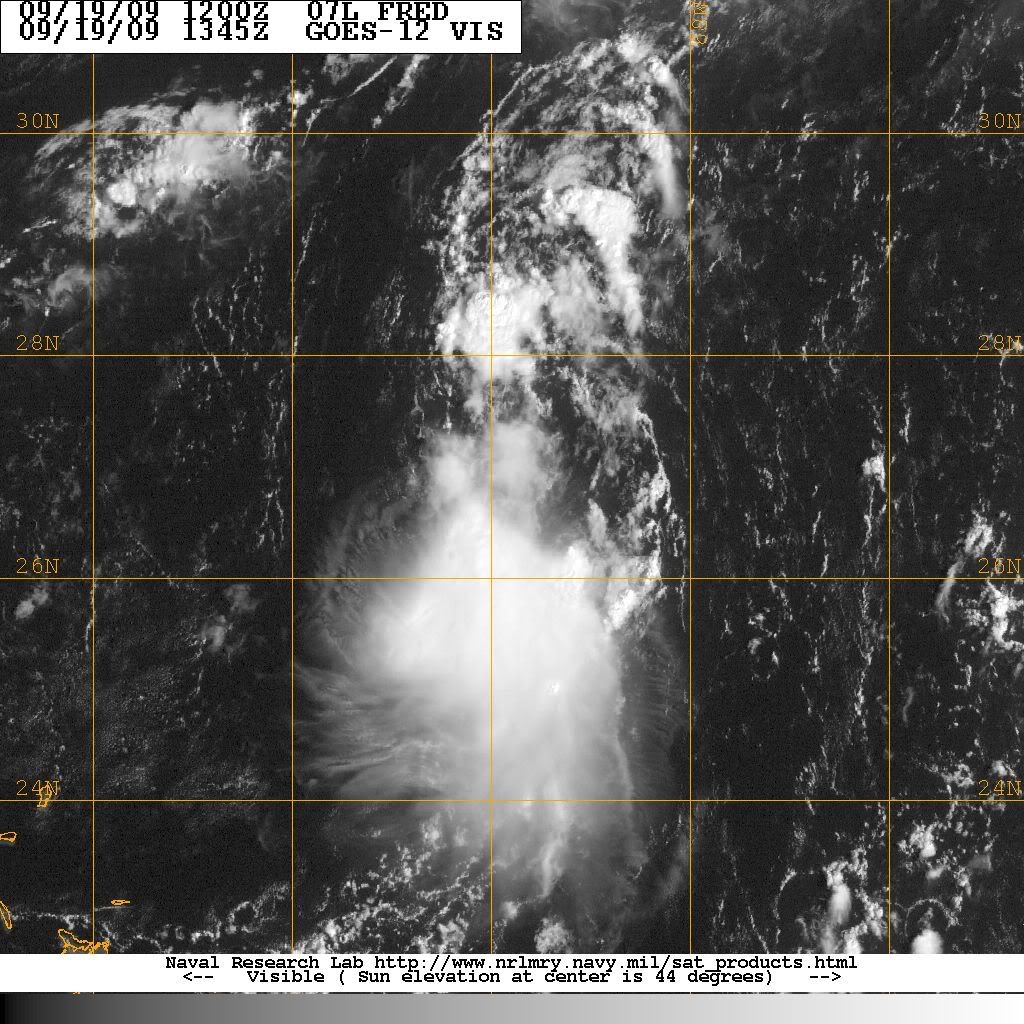
Emmett_Brown wrote:Well, Fred is looking stretched again. LLC is not obvious and tight like yesterday. Wxman's raid blast may have worked, hard to tell until the convection blows off the rest of the way.

I'm inclined to wait for a better visible loop.I don't see how we can make an informed analysis until we get one.
0 likes   

jlauderdal
S2K Supporter
S2K Supporter
Posts: 7183
Joined: Wed May 19, 2004 5:46 am
Location: NE Fort Lauderdale
Contact:

Re: ATL: TROPICAL LOW ex-FRED (ex-07L)

#1367 Postby jlauderdal » Sat Sep 19, 2009 9:12 am

breeze wrote:Did I just see a jog to the SW, or are my eyes playing tricks?


wobble watcher
0 likes   

User avatar
breeze
Category 5
Category 5
Posts: 9110
Age: 62
Joined: Sat Feb 08, 2003 4:55 pm
Location: Lawrenceburg, TN

Re: ATL: TROPICAL LOW ex-FRED (ex-07L)

#1368 Postby breeze » Sat Sep 19, 2009 9:13 am

:uarrow: I've been accused of worse... :lol:
0 likes   

jinftl
Category 5
Category 5
Posts: 4312
Joined: Tue Aug 31, 2004 4:47 pm
Location: fort lauderdale, fl

Re: ATL: TROPICAL LOW ex-FRED (ex-07L)

#1369 Postby jinftl » Sat Sep 19, 2009 9:14 am

A wsw component to the movement is not out of the question in the next few days....

Image

breeze wrote:Did I just see a jog to the SW, or are my eyes playing tricks?
0 likes   

User avatar
wzrgirl1
S2K Supporter
S2K Supporter
Posts: 1325
Joined: Sat Sep 04, 2004 6:44 am
Location: Pembroke Pines, Florida

Re: ATL: TROPICAL LOW ex-FRED (ex-07L)

#1370 Postby wzrgirl1 » Sat Sep 19, 2009 9:14 am

This has definitely sparked my interest with it being so close to home. Especially if it slows down as it seems like it may do. Always need to keep an eye on these things during this time of the year.
0 likes   

jlauderdal
S2K Supporter
S2K Supporter
Posts: 7183
Joined: Wed May 19, 2004 5:46 am
Location: NE Fort Lauderdale
Contact:

Re: ATL: TROPICAL LOW ex-FRED (ex-07L)

#1371 Postby jlauderdal » Sat Sep 19, 2009 9:15 am

I get some too because I posted a week or so ago that it was a fish for sure and I was only going to have one post about it so lets get this out of the way right now and move forward.

Image
0 likes   

User avatar
wzrgirl1
S2K Supporter
S2K Supporter
Posts: 1325
Joined: Sat Sep 04, 2004 6:44 am
Location: Pembroke Pines, Florida

Re: ATL: TROPICAL LOW ex-FRED (ex-07L)

#1372 Postby wzrgirl1 » Sat Sep 19, 2009 9:16 am

Looks like anywhere from central florida southward. I guess most models are picking up on a high pressure building in the next couple of days. The question is strength. Always the hardest to forecast.
0 likes   

User avatar
srainhoutx
S2K Supporter
S2K Supporter
Posts: 6919
Age: 67
Joined: Sun Jan 14, 2007 11:34 am
Location: Haywood County, NC
Contact:

Re: ATL: TROPICAL LOW ex-FRED (ex-07L)

#1373 Postby srainhoutx » Sat Sep 19, 2009 9:26 am

Image
0 likes   

jlauderdal
S2K Supporter
S2K Supporter
Posts: 7183
Joined: Wed May 19, 2004 5:46 am
Location: NE Fort Lauderdale
Contact:

Re: ATL: TROPICAL LOW ex-FRED (ex-07L)

#1374 Postby jlauderdal » Sat Sep 19, 2009 9:28 am

CYCLONE MIKE wrote:
jpigott wrote:I guess it's safe to say NWS Miami and NWS Melbourne don't see eye to eye on where this goes


Yea, that is pretty funny. The reasoning is because the GFS shows deep troughing over the east coast again while the other models show high pressure building in. I guess it comes down to which model they believe in.


im not sure what Miami is seeing but key west likes the south florida idea, they dont slow it down either and in fact open up the possibility of it moving a little faster but i suppose if you are going with a building ridge idea then that accounts for an increase in speed or at least no slowdown and if you go with a NW turn idea on an eroding ridge than of course we know the systems tend to slow down before a turn, seems strange and I would expect them all to be on the same page by this afternoon after some communication, of course NHC is right down the hall from NWS so we should have agreement by this afternoon especially after some recon which I fully expect

LONG TERM (MONDAY THROUGH FRIDAY)

THE REMNANTS OF FRED SHOULD MOVE ACROSS SOUTH FLORIDA AS AN OPEN
TROUGH OF LOW PRESSURE EARLY NEXT WEEK. TIMING IS DIFFICULT. AS A
RESULT...POPS WERE NOT DECREASED MONDAY AS THE REMNANTS OF FRED MAY
MAKE IT TO SOUTH FLORIDA SOONER THAN ANTICIPATED. MOST LIKELY...THE
REMNANTS OF FRED WILL GET TO SOUTH FLORIDA SOMETIME EITHER MONDAY
NIGHT OR TUESDAY. AN ATLANTIC RIDGE OF HIGH PRESSURE SHOULD EXTEND
ACROSS THE SOUTHEASTERN UNITED STATES TUESDAY NIGHT THROUGH FRIDAY.
NO CHANGES TO THE LONG TERM PORTION OF THE ZONE FORECASTS FOR THE
FLORIDA KEYS.
0 likes   

jlauderdal
S2K Supporter
S2K Supporter
Posts: 7183
Joined: Wed May 19, 2004 5:46 am
Location: NE Fort Lauderdale
Contact:

Re: ATL: TROPICAL LOW ex-FRED (ex-07L)

#1375 Postby jlauderdal » Sat Sep 19, 2009 9:38 am

jinftl wrote:A wsw component to the movement is not out of the question in the next few days....

Image

breeze wrote:Did I just see a jog to the SW, or are my eyes playing tricks?


yeah, right at about 26.2 N
0 likes   

User avatar
MortisFL
Category 1
Category 1
Posts: 391
Age: 42
Joined: Mon Jul 21, 2003 9:01 am
Location: Sarasota, FL
Contact:

Re: ATL: TROPICAL LOW ex-FRED (ex-07L)

#1376 Postby MortisFL » Sat Sep 19, 2009 9:39 am

lauderdale, you are guaranteed an isolated sprinkle =)
0 likes   

CajunMama
Retired Staff
Retired Staff
Posts: 10791
Joined: Thu Feb 06, 2003 9:57 pm
Location: 30.22N, 92.05W Lafayette, LA

Re: ATL: TROPICAL LOW ex-FRED (ex-07L)

#1377 Postby CajunMama » Sat Sep 19, 2009 9:40 am

Stephanie wrote:
wxman57 wrote:I'm going find a big can of Raid...


I'll pack some tonight. I'm heading to the Bahamas tomorrow.... :x

I know it's a chance you take when you book trips there during this time of the year....


I hope Fredex doesn't put a damper on your trip. Have fun.
0 likes   

User avatar
alienstorm
Category 1
Category 1
Posts: 496
Joined: Tue Jul 31, 2007 1:29 pm
Location: Miami Fla western suburb

Re: ATL: TROPICAL LOW ex-FRED (ex-07L)

#1378 Postby alienstorm » Sat Sep 19, 2009 9:41 am

Looking at High Resolution Visible it looks like it's open up totally and no longer seems to be a low - looks like it finally has dissappated.
0 likes   

User avatar
Thunder44
Category 5
Category 5
Posts: 5922
Age: 44
Joined: Mon Jun 09, 2003 7:53 pm
Location: New York City

Re: ATL: TROPICAL LOW ex-FRED - RECON

#1379 Postby Thunder44 » Sat Sep 19, 2009 9:45 am

Flight for today has been cancelled. And no more are scheduled:

000
NOUS42 KNHC 191500
WEATHER RECONNAISSANCE FLIGHTS
CARCAH, NATIONAL HURRICANE CENTER, MIAMI, FL.
1100 AM EDT SAT 19 SEPTEMBER 2009
SUBJECT: TROPICAL CYCLONE PLAN OF THE DAY (TCPOD)
VALID 20/1100Z TO 21/1100Z SEPTEMBER 2009
TCPOD NUMBER.....09-114

I. ATLANTIC REQUIREMENTS
1. NEGATIVE RECONNAISSANCE REQUIREMENTS.
2. SUCCEEDING DAY OUTLOOK.....NEGATIVE.
3. NOTE: ALL TASKING ON THE REMNANTS OF HURRICANE FRED
WERE CANX BY NHC AT 19/1415Z.
0 likes   

jlauderdal
S2K Supporter
S2K Supporter
Posts: 7183
Joined: Wed May 19, 2004 5:46 am
Location: NE Fort Lauderdale
Contact:

Re: ATL: TROPICAL LOW ex-FRED (ex-07L)

#1380 Postby jlauderdal » Sat Sep 19, 2009 9:52 am

MortisFL wrote:lauderdale, you are guaranteed an isolated sprinkle =)


if it develops and i get out there and start my generator like i did for ike it stands no chance of coming here
0 likes   


Return to “2009”

Who is online

Users browsing this forum: No registered users and 3 guests