ENSO Updates (2007 thru 2023)
Moderator: S2k Moderators
Forum rules
The posts in this forum are NOT official forecasts and should not be used as such. They are just the opinion of the poster and may or may not be backed by sound meteorological data. They are NOT endorsed by any professional institution or STORM2K. For official information, please refer to products from the National Hurricane Center and National Weather Service.
- cycloneye
- Admin

- Posts: 149153
- Age: 69
- Joined: Thu Oct 10, 2002 10:54 am
- Location: San Juan, Puerto Rico
Re: ENSO Updates
Australians 8/5/09 update
Summary: El Niño slowly consolidating in the Pacific
Atmospheric indicators are increasingly showing patterns typical of a developing El Niño event. These indicators are driven by warm conditions in the tropical Pacific Ocean. If these warm conditions persist, as forecast by leading climate models, 2009 will be considered an El Niño year.
Pacific Ocean surface temperatures continue to exceed El Niño thresholds. As a result, cloud patterns, Trade winds and rainfall along the equator have all shown signs of responding to the warmer ocean conditions. The Southern Oscillation Index (SOI) has fallen over the past two weeks, and is now near zero: persistent negative values are a feature of El Niño events.
The last month has seen below average rainfall across much of eastern Australia with particularly dry conditions through Queensland. El Niño periods are usually (but not always) associated with below normal rainfall in the second half of the year across large parts of southern and inland eastern Australia.
The most recent value of the Indian Ocean Dipole (IOD), as measured by the Dipole Mode Index (DMI), is near zero. The Bureau's POAMA model suggests the DMI may increase over the coming months, consistent with the developing El Niño event.
Detailed analysis
The central and eastern equatorial Pacific sea surface warmed through July. This area of ocean has been steadily warming since February 2009. Positive sea surface temperature (SST) anomalies are now well established across the central to eastern equatorial Pacific. The monthly NINO indices for July were +1.1°C, +0.8°C and +0.6°C for NINO3, NINO3.4 and NINO4 respectively. The NINO3 value increased the most between June and July, increasing by 0.3°C.
In terms of weekly data, the most recent NINO indices are +1.0°C, +0.8°C and +0.6°C for NINO3, NINO3.4 and NINO4 respectively. Over the past two weeks there has been little change in the weekly NINO index values. Consistent with the establishment of an El Niño, the 7-day SST anomaly map shows a persistence of positive anomalies of greater than +1.0°C across much of the central and eastern equatorial Pacific. Should these warm anomalies persist through the remainder of the southern winter and into spring, 2009 will be classed as an El Niño year. An animation of recent SST changes is available.
Below the surface of the tropical Pacific the ocean is also much warmer than the long-term mean. A four-month sequence of Pacific Ocean equatorial temperature anomaly is available here. The sequence shows steady warming of sub-surface water through each month except July. A slight cooling of the sub-surface was observed in July, however, most of the sub-surface remained significantly warmer than the long-term mean. A recent map for the 5 days ending 3 August shows warmer than normal sub-surface water extending across most of the equatorial Pacific. Anomalies exceeding +1.0°C are evident across much of the equatorial Pacific, with anomalies exceeding +3.0°C in the far east. When compared with two weeks ago, the sub-surface has cooled slightly in the central to western Pacific, but warmed in the far east. An animation of recent sub-surface changes is available.
An archive of past SST and sub-surface temperature charts is available.
Trade Winds have been consistently weaker than average over the far west of the tropical Pacific in recent months. The Trade Winds have fluctuated over the central to eastern equatorial Pacific but have generally been slightly weaker than normal. The latest weekly wind anomalies are shown in the TAO/TRITON map (small image above) for the five days ending 3 August.
The Southern Oscillation Index (SOI) is currently near zero with a 30 day value (3 August) of +0.5. The SOI has fallen rapidly over the past two weeks, from a strongly positive value of +12 on the 19 July. The SOI value for July was +2. The SOI is usually negative during El Niño events. As the equatorial Pacific continues to warm and Trade Winds remain generally weak the SOI is likely to fall further. (SOI graph, SOI table).
Cloudiness near the date-line over the equatorial Pacific is another important indicator of El Niño conditions, as it typically increases during these episodes. Cloudiness near the date-line has increased steadily in recent months. Consistent with a developing El Niño, cloudiness near the date-line has generally been greater than normal over the past month. This is supported by satellite measurements of rainfall, which show above average in rainfall along the equator in areas near and to the east of the dateline.
Six of seven international dynamic computer models surveyed by the Bureau of Meteorology predict that Pacific Ocean SST will remain above El Niño thresholds throughout the remainder of 2009. Only one of the models shows near neutral conditions. Given the high level of persistence (and therefore predictability) in ENSO during the second half of the year, the probability of an El Niño even continuing to develop and maturing late in 2009 is high. Recent forecasts from the POAMA model, run daily at the Bureau of Meteorology, show a steady warming with SST remaining above El Niño thresholds throughout 2009. Pacific conditions and model predictions will continue to be monitored closely.
http://www.bom.gov.au/climate/enso/
0 likes
- cycloneye
- Admin

- Posts: 149153
- Age: 69
- Joined: Thu Oct 10, 2002 10:54 am
- Location: San Juan, Puerto Rico
Re: ENSO Updates
SOI Index turns to negative
Daily SOI Index
http://www.longpaddock.qld.gov.au/Seaso ... SOIValues/
30 day SOI Index
2009060420090703 .4
2009060520090704 .4
2009060620090705 1.2
2009060720090706 .5
2009060820090707 .6
2009060920090708 .6
2009061020090709 2.9
2009061120090710 4.5
2009061220090711 5.9
2009061320090712 8.2
2009061420090713 8.9
2009061520090714 8.9
2009061620090715 8.2
2009061720090716 8.2
2009061820090717 9.6
2009061920090718 11
2009062020090719 11.7
2009062120090720 11.6
2009062220090721 10.9
2009062320090722 10.2
2009062420090723 9.5
2009062520090724 8.8
2009062620090725 7.5
2009062720090726 6.8
2009062820090727 5.5
2009062920090728 4.2
2009063020090729 2.2
2009070120090730 1.6
2009070220090731 1.6
2009070320090801 1.4
2009070420090802 .6
2009070520090803 .5
2009070620090804 -.3

http://www.bom.gov.au/climate/enso/soi.dt3
Is the first time since July 3rd that the 30 day SOI index falls to negative.
Daily SOI Index
http://www.longpaddock.qld.gov.au/Seaso ... SOIValues/
30 day SOI Index
2009060420090703 .4
2009060520090704 .4
2009060620090705 1.2
2009060720090706 .5
2009060820090707 .6
2009060920090708 .6
2009061020090709 2.9
2009061120090710 4.5
2009061220090711 5.9
2009061320090712 8.2
2009061420090713 8.9
2009061520090714 8.9
2009061620090715 8.2
2009061720090716 8.2
2009061820090717 9.6
2009061920090718 11
2009062020090719 11.7
2009062120090720 11.6
2009062220090721 10.9
2009062320090722 10.2
2009062420090723 9.5
2009062520090724 8.8
2009062620090725 7.5
2009062720090726 6.8
2009062820090727 5.5
2009062920090728 4.2
2009063020090729 2.2
2009070120090730 1.6
2009070220090731 1.6
2009070320090801 1.4
2009070420090802 .6
2009070520090803 .5
2009070620090804 -.3

http://www.bom.gov.au/climate/enso/soi.dt3
Is the first time since July 3rd that the 30 day SOI index falls to negative.
0 likes
- cycloneye
- Admin

- Posts: 149153
- Age: 69
- Joined: Thu Oct 10, 2002 10:54 am
- Location: San Juan, Puerto Rico
Re: ENSO Updates
Climate Prediction Center August Update
What we have right now is a weak el nino that is forecast to grow to moderate or at least be between weak to moderate by the winter months.
Synopsis: El Niño is expected to strengthen and last through the Northern Hemisphere Winter 2009-2010.
A weak El Niño was present during July 2009, as monthly sea surface temperatures (SST) departures ranged from +0.5oC to +1.5oC across the equatorial Pacific Ocean, with the largest anomalies in the eastern half of the basin (Fig. 1). Consistent with this warmth, all of the Niño-region SST indices were between +0.6oC to +1.0oC throughout the month (Fig. 2). Subsurface oceanic heat content (average temperatures in the upper 300m of the ocean, Fig. 3) anomalies continued to reflect a deep layer of anomalous warmth between the ocean surface and thermocline (Fig. 4). Also, convection was suppressed over Indonesia and enhanced across the western Pacific and near the International Date Line. In addition, developing El Niño’s often feature westerly wind bursts over the western equatorial Pacific, such as the one which occurred at the end of July (Fig. 5). These oceanic and atmospheric anomalies reflect El Niño.
A majority of the model forecasts for the Niño-3.4 SST index (Fig. 6) suggest El Niño will continue to strengthen. While there is disagreement on the eventual strength of El Niño, nearly all of the dynamical models predict a moderate-to-strong El Niño during the Northern Hemisphere Winter 2009-10. A strengthening El Niño during the next few months is also suggested by the recent westerly wind event in the western equatorial Pacific, which can lead to additional anomalous warmth across the central and east-central equatorial Pacific during the next two months. Therefore, current conditions and model forecasts favor the continued development of a weak-to-moderate strength El Niño into the Northern Hemisphere Fall 2009, with the likelihood of at least a moderate strength El Niño (3-month Niño-3.4 SST index of +1.0oC or greater) during the Northern Hemisphere Winter 2009-10.
Expected El Niño impacts during August-October 2009 include enhanced precipitation over the central and west-central Pacific Ocean and the continuation of drier than average conditions over Indonesia. Temperature and precipitation impacts over the United States are typically weak during the Northern Hemisphere Summer and early Fall, and generally strengthen during the late Fall and Winter. El Niño can help to suppress Atlantic hurricane activity by increasing the vertical wind shear over the Caribbean Sea and tropical Atlantic Ocean.
http://www.cpc.ncep.noaa.gov/products/a ... odisc.html
0 likes
Re: ENSO Updates
No significant change in today's el nino update....all-in-all, as we have see for the last month+, el nino is holding steady....certainly not strengthening
Current:
Niño 4=+0.6ºC
Niño 3.4=+0.8ºC
Niño 3=+0.9ºC
Niño1+2=+1.0ºC
Last Week:
Niño 4=+0.6ºC
Niño 3.4=+0.8ºC
Niño 3=+0.9ºC
Niño1+2=+0.7ºC
Two Weeks Ago:
Niño 4= +0.6ºC
Niño 3.4= +0.9ºC
Niño 3= +1.0ºC
Niño1+2= +0.8ºC
Current:
Niño 4=+0.6ºC
Niño 3.4=+0.8ºC
Niño 3=+0.9ºC
Niño1+2=+1.0ºC
Last Week:
Niño 4=+0.6ºC
Niño 3.4=+0.8ºC
Niño 3=+0.9ºC
Niño1+2=+0.7ºC
Two Weeks Ago:
Niño 4= +0.6ºC
Niño 3.4= +0.9ºC
Niño 3= +1.0ºC
Niño1+2= +0.8ºC
0 likes
- cycloneye
- Admin

- Posts: 149153
- Age: 69
- Joined: Thu Oct 10, 2002 10:54 am
- Location: San Juan, Puerto Rico
Re: ENSO Updates
jinftl wrote:No significant change in today's el nino update....all-in-all, as we have see for the last month+, el nino is holding steady....certainly not strengthening
Current:
Niño 4=+0.6ºC
Niño 3.4=+0.8ºC
Niño 3=+0.9ºC
Niño1+2=+1.0ºC
Last Week:
Niño 4=+0.6ºC
Niño 3.4=+0.8ºC
Niño 3=+0.9ºC
Niño1+2=+0.7ºC
Two Weeks Ago:
Niño 4= +0.6ºC
Niño 3.4= +0.9ºC
Niño 3= +1.0ºC
Niño1+2= +0.8ºC
Oh boy,I forgot that with many things going on in the tropics.
0 likes
Re: ENSO Updates
Don't worry...as you can see, nothing really has changed!
cycloneye wrote:jinftl wrote:No significant change in today's el nino update....all-in-all, as we have see for the last month+, el nino is holding steady....certainly not strengthening
Current:
Niño 4=+0.6ºC
Niño 3.4=+0.8ºC
Niño 3=+0.9ºC
Niño1+2=+1.0ºC
Last Week:
Niño 4=+0.6ºC
Niño 3.4=+0.8ºC
Niño 3=+0.9ºC
Niño1+2=+0.7ºC
Two Weeks Ago:
Niño 4= +0.6ºC
Niño 3.4= +0.9ºC
Niño 3= +1.0ºC
Niño1+2= +0.8ºC
Oh boy,I forgot that with many things going on in the tropics.
0 likes
Re: ENSO Updates
jinftl wrote:Don't worry...as you can see, nothing really has changed!
Niño 1+2 has warmed a little more than a bit
0 likes
Re: ENSO Updates
true, but as we know, the nino 3.4 region is the basis for the classification of el nino...and that has remain unchanged (actually gone from 0.9C two weeks ago to 0.8C last week and held constant at 0.8C this week as well). Nino 1+2 is not where we look to for el nino determination.
Macrocane wrote:jinftl wrote:Don't worry...as you can see, nothing really has changed!
Niño 1+2 has warmed a little more than a bit
0 likes
- cycloneye
- Admin

- Posts: 149153
- Age: 69
- Joined: Thu Oct 10, 2002 10:54 am
- Location: San Juan, Puerto Rico
Re: ENSO Updates
Climate Prediction Center 8/17/09 update
The biggest change is at el nino 1-2 as it went down to +0.5C.
Last weeks numbers:
Niño 4=+0.6ºC
Niño 3.4=+0.8ºC
Niño 3=+0.9ºC
Niño1+2=+1.0ºC
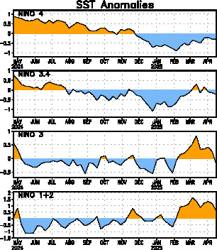
The latest weekly SST departures are:
Niño 4=+0.7ºC
Niño 3.4=+0.7ºC
Niño 3=+0.9ºC
Niño1+2=+0.5ºC
http://www.cpc.ncep.noaa.gov/products/a ... ts-web.pdf
The biggest change is at el nino 1-2 as it went down to +0.5C.
Last weeks numbers:
Niño 4=+0.6ºC
Niño 3.4=+0.8ºC
Niño 3=+0.9ºC
Niño1+2=+1.0ºC
The latest weekly SST departures are:
Niño 4=+0.7ºC
Niño 3.4=+0.7ºC
Niño 3=+0.9ºC
Niño1+2=+0.5ºC

http://www.cpc.ncep.noaa.gov/products/a ... ts-web.pdf
0 likes
Re: ENSO Updates=Climate Prediction Center 8/17/09 update
It seems that El Niño will be weaker than predicted unless a very rapid warming occurs.
0 likes
- cycloneye
- Admin

- Posts: 149153
- Age: 69
- Joined: Thu Oct 10, 2002 10:54 am
- Location: San Juan, Puerto Rico
Re: ENSO Updates=BoM 8/18/09=Development of El nino slows
Peeps,this is important news that El Nino is not developing more.Read the Australians update below.
Summary: Mixed El Niño indicators as development slows.
The El Niño pattern across the Pacific has not intensified during the past fortnight. Furthermore, the coupling between the ocean and atmosphere which amplifies and maintains El Niño events has so far failed to eventuate. The neutral SOI and sub-surface cooling are evidence of this.
However, the Trade Winds are weakening over a broad area and this may promote renewed warming. In addition, leading climate models continue to predict further development of the El Niño, although not as emphatically as a month or two back. Therefore, the odds remain strongly in favour of 2009 being recognised as an El Niño year.
July and August have seen below average rainfall across much of eastern Australia, with particularly dry conditions through Queensland and northern NSW. El Niño events are usually (but not always) associated with below normal rainfall in the second half of the year across large parts of southern and inland eastern Australia.
In addition, conditions have recently been very warm for the time of year across Australia, with maximum temperatures consistently more than 4°C above normal over wide areas.
The most recent value of the Indian Ocean Dipole (IOD), as measured by the Dipole Mode Index (DMI), is near zero. The Bureau's POAMA model suggests the DMI should remain neutral over the coming months.
Details
The Pacific Ocean sea surface is currently significantly warmer than the long-term mean across almost all equatorial regions. The sea surface temperature (SST) anomaly map for July is available here; it shows warm anomalies extending along most of the equator, with significant warm anomalies in excess of 1°C covering much of the central to eastern equatorial Pacific. The monthly NINO indices for July were +1.1°C, +0.8°C and +0.6°C for NINO3, NINO3.4 and NINO4 respectively.
In terms of weekly data, the most recent NINO indices are +0.9°C, +0.7°C and +0.9°C for NINO3, NINO3.4 and NINO4 respectively. Both NINO3 and NINO3.4 have cooled by about 0.2°C over the past seven weeks. In contrast, NINO4 has warmed by approximately 0.3°C during the past fortnight. The 7-day SST anomaly map shows significantly warmer than normal SST across almost the entire tropical Pacific. The warm SST anomalies to the west of NINO4, in the Australasian region, run contrary to what is expected during a typical El Niño as persistent cool anomalies in the Australasian region is a normal feature of El Niño events. An animation of recent SST changes is available.
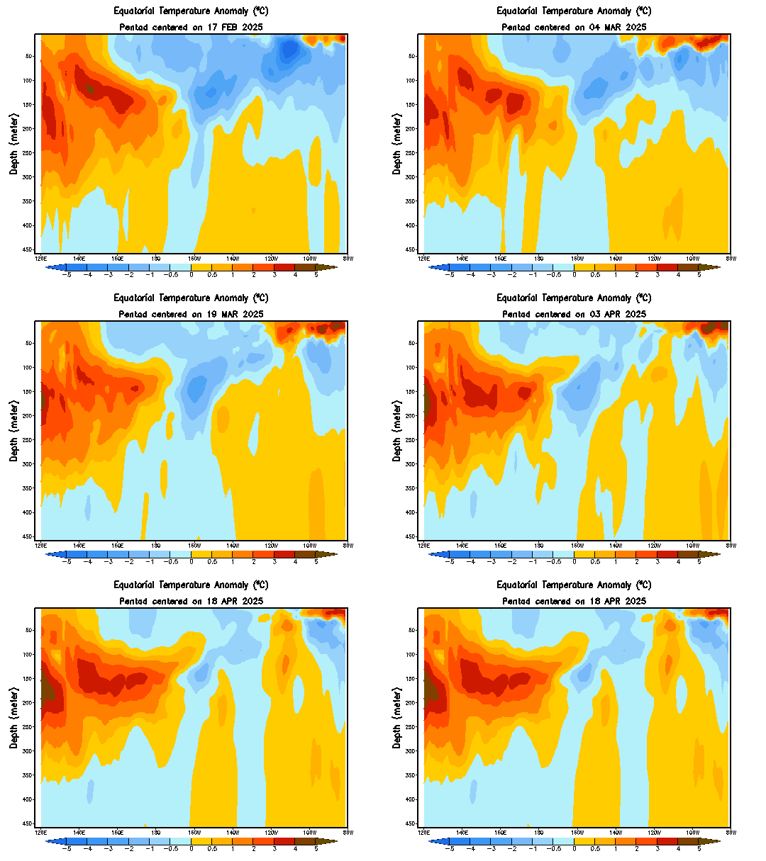
Below the surface of the tropical Pacific, the ocean is also warmer than the long-term mean. However, the sub-surface water has cooled steadily through July and the first half of August. A four-month sequence of Pacific Ocean equatorial temperature anomaly is available here. A recent map for the 5 days ending 16 August shows warmer than normal sub-surface water extending across most of the equatorial Pacific. However, when compared with two weeks ago, the sub-surface has cooled slightly in the eastern and western Pacific, but warmed slightly in central parts. An animation of recent sub-surface changes is available.
An archive of past SST and sub-surface temperature charts is available.
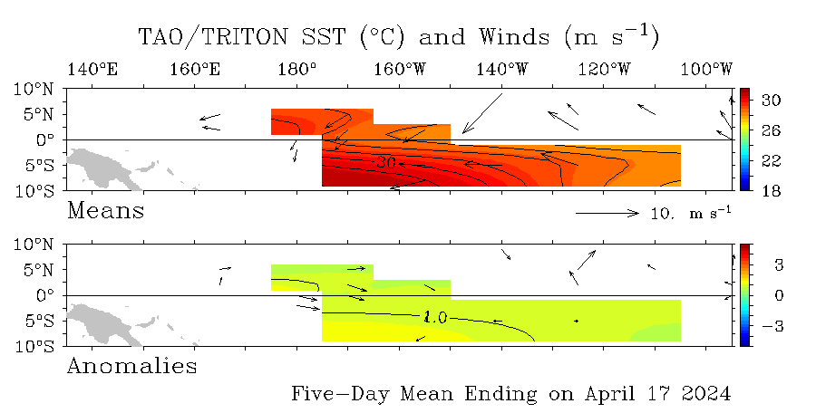
Trade Winds have been consistently weaker than average over the far west of the tropical Pacific in recent months. The Trade Winds have fluctuated over the central to eastern equatorial Pacific but have generally been slightly weaker than normal, particularly in recent weeks. The latest weekly wind anomalies are shown in the TAO/TRITON map (small image above) for the five days ending 16 August. The map shows that on a weekly scale, westerly anomalies are well established over most of the western Pacific, extending to around 170°W.
The Southern Oscillation Index (SOI) has been falling steadily since the middle of July. The index is now slightly negative, with a current approximate 30-day value (16 August) of −4. The index peaked in July with a strongly positive value of +12 on the 19 July. The average SOI for the month of July was +2. The SOI is usually negative during El Niño events, therefore the recent positive values run contrary to what is expected during an El Niño event. (SOI graph, SOI table).
Cloudiness near the date-line over the equatorial Pacific is another important indicator of El Niño conditions, as it typically increases during these episodes. Cloudiness near the date-line has increased steadily in recent months. Consistent with a developing El Niño, cloudiness near the date-line was generally greater than normal through most of July. However, in recent weeks cloudiness has decreased slightly, and for the first half of August, cloudiness near the date line was generally less than the long-term average.
Six of seven international dynamic computer models surveyed by the Bureau of Meteorology predict that Pacific Ocean SST will remain above El Niño thresholds throughout the remainder of 2009. Only one of the models shows near neutral conditions. Given the high level of persistence (and therefore predictability) in ENSO during the second half of the year, the probability of an El Niño event continuing to develop and maturing late in 2009 is high. Recent forecasts from the POAMA model, run daily at the Bureau of Meteorology, show a steady warming with SST remaining above El Niño thresholds throughout 2009. Pacific conditions and model predictions will continue to be monitored closely.
http://www.bom.gov.au/climate/enso/
Notice at subsurface image below that is not as warm than in June and July.
Summary: Mixed El Niño indicators as development slows.
The El Niño pattern across the Pacific has not intensified during the past fortnight. Furthermore, the coupling between the ocean and atmosphere which amplifies and maintains El Niño events has so far failed to eventuate. The neutral SOI and sub-surface cooling are evidence of this.
However, the Trade Winds are weakening over a broad area and this may promote renewed warming. In addition, leading climate models continue to predict further development of the El Niño, although not as emphatically as a month or two back. Therefore, the odds remain strongly in favour of 2009 being recognised as an El Niño year.
July and August have seen below average rainfall across much of eastern Australia, with particularly dry conditions through Queensland and northern NSW. El Niño events are usually (but not always) associated with below normal rainfall in the second half of the year across large parts of southern and inland eastern Australia.
In addition, conditions have recently been very warm for the time of year across Australia, with maximum temperatures consistently more than 4°C above normal over wide areas.
The most recent value of the Indian Ocean Dipole (IOD), as measured by the Dipole Mode Index (DMI), is near zero. The Bureau's POAMA model suggests the DMI should remain neutral over the coming months.
Details
The Pacific Ocean sea surface is currently significantly warmer than the long-term mean across almost all equatorial regions. The sea surface temperature (SST) anomaly map for July is available here; it shows warm anomalies extending along most of the equator, with significant warm anomalies in excess of 1°C covering much of the central to eastern equatorial Pacific. The monthly NINO indices for July were +1.1°C, +0.8°C and +0.6°C for NINO3, NINO3.4 and NINO4 respectively.
In terms of weekly data, the most recent NINO indices are +0.9°C, +0.7°C and +0.9°C for NINO3, NINO3.4 and NINO4 respectively. Both NINO3 and NINO3.4 have cooled by about 0.2°C over the past seven weeks. In contrast, NINO4 has warmed by approximately 0.3°C during the past fortnight. The 7-day SST anomaly map shows significantly warmer than normal SST across almost the entire tropical Pacific. The warm SST anomalies to the west of NINO4, in the Australasian region, run contrary to what is expected during a typical El Niño as persistent cool anomalies in the Australasian region is a normal feature of El Niño events. An animation of recent SST changes is available.
Below the surface of the tropical Pacific, the ocean is also warmer than the long-term mean. However, the sub-surface water has cooled steadily through July and the first half of August. A four-month sequence of Pacific Ocean equatorial temperature anomaly is available here. A recent map for the 5 days ending 16 August shows warmer than normal sub-surface water extending across most of the equatorial Pacific. However, when compared with two weeks ago, the sub-surface has cooled slightly in the eastern and western Pacific, but warmed slightly in central parts. An animation of recent sub-surface changes is available.
An archive of past SST and sub-surface temperature charts is available.
Trade Winds have been consistently weaker than average over the far west of the tropical Pacific in recent months. The Trade Winds have fluctuated over the central to eastern equatorial Pacific but have generally been slightly weaker than normal, particularly in recent weeks. The latest weekly wind anomalies are shown in the TAO/TRITON map (small image above) for the five days ending 16 August. The map shows that on a weekly scale, westerly anomalies are well established over most of the western Pacific, extending to around 170°W.
The Southern Oscillation Index (SOI) has been falling steadily since the middle of July. The index is now slightly negative, with a current approximate 30-day value (16 August) of −4. The index peaked in July with a strongly positive value of +12 on the 19 July. The average SOI for the month of July was +2. The SOI is usually negative during El Niño events, therefore the recent positive values run contrary to what is expected during an El Niño event. (SOI graph, SOI table).
Cloudiness near the date-line over the equatorial Pacific is another important indicator of El Niño conditions, as it typically increases during these episodes. Cloudiness near the date-line has increased steadily in recent months. Consistent with a developing El Niño, cloudiness near the date-line was generally greater than normal through most of July. However, in recent weeks cloudiness has decreased slightly, and for the first half of August, cloudiness near the date line was generally less than the long-term average.
Six of seven international dynamic computer models surveyed by the Bureau of Meteorology predict that Pacific Ocean SST will remain above El Niño thresholds throughout the remainder of 2009. Only one of the models shows near neutral conditions. Given the high level of persistence (and therefore predictability) in ENSO during the second half of the year, the probability of an El Niño event continuing to develop and maturing late in 2009 is high. Recent forecasts from the POAMA model, run daily at the Bureau of Meteorology, show a steady warming with SST remaining above El Niño thresholds throughout 2009. Pacific conditions and model predictions will continue to be monitored closely.
http://www.bom.gov.au/climate/enso/

Notice at subsurface image below that is not as warm than in June and July.

0 likes
- cycloneye
- Admin

- Posts: 149153
- Age: 69
- Joined: Thu Oct 10, 2002 10:54 am
- Location: San Juan, Puerto Rico
Re: ENSO Updates
Climate Prediction Center 8/24/09 update
Last week numbers:
Niño 4=+0.7ºC
Niño 3.4=+0.7ºC
Niño 3=+0.9ºC
Niño1+2=+0.5ºC
This week SST departures are:
Niño 4= +0.8ºC
Niño 3.4= +0.7ºC
Niño 3= +0.9ºC
Niño1+2= +0.8ºC
http://www.cpc.ncep.noaa.gov/products/a ... ts-web.pdf

Last week numbers:
Niño 4=+0.7ºC
Niño 3.4=+0.7ºC
Niño 3=+0.9ºC
Niño1+2=+0.5ºC
This week SST departures are:
Niño 4= +0.8ºC
Niño 3.4= +0.7ºC
Niño 3= +0.9ºC
Niño1+2= +0.8ºC
http://www.cpc.ncep.noaa.gov/products/a ... ts-web.pdf

0 likes
- El Nino
- Category 1

- Posts: 454
- Age: 48
- Joined: Sun Oct 16, 2005 3:18 pm
- Location: Lima - Miraflores (Peru)
- Contact:
Re: ENSO Updates=Climate Prediction Center 8/24/09 update
2 days in a row of fine weather with sunshine in the afternoon here in Lima. Quite unusual ... Something to do with El Nino ?
0 likes
- cycloneye
- Admin

- Posts: 149153
- Age: 69
- Joined: Thu Oct 10, 2002 10:54 am
- Location: San Juan, Puerto Rico
Re: ENSO Updates
Climate Prediction Center 8/31/09 update
Last week numbers:
Niño 4= +0.8ºC
Niño 3.4= +0.7ºC
Niño 3= +0.9ºC
Niño1+2= +0.8ºC
This weeks numbers:
Niño 4= +0.9ºC
Niño 3.4=+0.9ºC
Niño 3= +1.0ºC
Niño1+2= +0.8ºC


Last week numbers:
Niño 4= +0.8ºC
Niño 3.4= +0.7ºC
Niño 3= +0.9ºC
Niño1+2= +0.8ºC
This weeks numbers:
Niño 4= +0.9ºC
Niño 3.4=+0.9ºC
Niño 3= +1.0ºC
Niño1+2= +0.8ºC


0 likes
- cycloneye
- Admin

- Posts: 149153
- Age: 69
- Joined: Thu Oct 10, 2002 10:54 am
- Location: San Juan, Puerto Rico
Re: ENSO Updates=CPC 9/10/09 update=Weak to moderate el nino
Climate Prediction Center 9/10/09 update
Synopsis: El Niño is expected to strengthen and last through the Northern Hemisphere winter 2009-2010.
A weak El Niño continued during August 2009, as sea surface temperature (SST) remained above-average across the equatorial Pacific Ocean (Fig. 1). Consistent with this warmth, the latest weekly values of the Niño-region SST indices were between +0.7oC to +1.0oC (Fig. 2). Subsurface oceanic heat content (average temperatures in the upper 300m of the ocean, Fig. 3) anomalies continued to reflect a deep layer of anomalous warmth between the ocean surface and the thermocline, particularly in the central Pacific (Fig. 4). Enhanced convection over the western and central Pacific abated during the month, but the pattern of suppressed convection strengthened over Indonesia. Low-level westerly wind anomalies continued to become better established over parts of the equatorial Pacific Ocean. These oceanic and atmospheric anomalies reflect an ongoing weak El Niño.
A majority of the model forecasts for the Niño-3.4 SST index (Fig. 5) suggest El Niño will reach at least moderate strength during the Northern Hemisphere fall (3-month Niño-3.4 SST index of +1.0oC or greater). Many model forecasts even suggest a strong El Niño (3-month Niño-3.4 SST index in excess of +1.5oC) during the fall and winter, but current observations and trends indicate that El Niño will most likely peak at moderate strength. Therefore, current conditions, trends, and model forecasts favor the continued development of a weak-to-moderate strength El Niño into the Northern Hemisphere fall 2009, with the likelihood of at least a moderate strength El Niño during the winter 2009-10.
Expected El Niño impacts during September-November 2009 include enhanced precipitation over the west-central tropical Pacific Ocean and the continuation of drier-than-average conditions over Indonesia. Temperature and precipitation impacts over the United States are typically weak during the Northern Hemisphere summer and early fall, generally strengthening during the late fall and winter. El Niño can help to suppress Atlantic hurricane activity by increasing the vertical wind shear over the Caribbean Sea and tropical Atlantic Ocean (see the Aug. 6th update of the NOAA Atlantic Seasonal Hurricane Outlook).
http://www.cpc.ncep.noaa.gov/products/a ... odisc.html
0 likes
- El Nino
- Category 1

- Posts: 454
- Age: 48
- Joined: Sun Oct 16, 2005 3:18 pm
- Location: Lima - Miraflores (Peru)
- Contact:
Re: ENSO Updates
I really don't understand what's happening with El Nino this year ... Sometimes, you think it will come, sometimes it gets cooler ... Really strange !
0 likes
- cycloneye
- Admin

- Posts: 149153
- Age: 69
- Joined: Thu Oct 10, 2002 10:54 am
- Location: San Juan, Puerto Rico
Re: ENSO Updates
Climate Prediction Center 9/14/09 Update
A little less warm Pacific than last week.
Last week SST departures:
Niño 4= +0.9ºC
Niño 3.4=+0.9ºC
Niño 3= +1.0ºC
Niño1+2= +0.8ºC
This week SST departures:
Niño 4=0.8ºC
Niño 3.4=0.9ºC
Niño 3=0.8ºC
Niño1+2=0.5ºC

http://www.cpc.ncep.noaa.gov/products/a ... ts-web.pdf
A little less warm Pacific than last week.
Last week SST departures:
Niño 4= +0.9ºC
Niño 3.4=+0.9ºC
Niño 3= +1.0ºC
Niño1+2= +0.8ºC
This week SST departures:
Niño 4=0.8ºC
Niño 3.4=0.9ºC
Niño 3=0.8ºC
Niño1+2=0.5ºC

http://www.cpc.ncep.noaa.gov/products/a ... ts-web.pdf
0 likes
- cycloneye
- Admin

- Posts: 149153
- Age: 69
- Joined: Thu Oct 10, 2002 10:54 am
- Location: San Juan, Puerto Rico
Re: ENSO Updates
Australians 9/16/09 Update
Weak to Moderate El Nino for the rest of 2009 and early part of 2010.They say is an unusual El Nino because of some factors (SOI turning possitive one of them) that you can read at the update below.
Details
The Pacific Ocean sea surface remains significantly warmer than the long-term mean across almost all equatorial regions. The SST anomaly map for August is available here; the map shows warm anomalies extending along the equator, with anomalies in excess of +1°C evident across some central to eastern areas. The monthly NINO indices for August were +1.0°C, +0.8°C and +0.9°C for NINO3, NINO3.4 and NINO4 respectively. The warm SST anomalies to the west of NINO4, in the Australasian region, run contrary to what is expected during a typical El Niño as persistent cool anomalies in the Australasian region is a normal featurer.
In terms of weekly data, the most recent NINO indices are +1.0°C, +0.9°C and +0.9°C for NINO3, NINO3.4 and NINO4 respectively. When compared with August values the current NINO indices have shown little change. When compared with either August or July values, the current NINO indices have shown little change, apart from NINO4 which has warmed by approximately 0.3°C since July. The 7-day SST anomaly map shows significantly warmer than normal SST across almost the entire tropical Pacific. An animation of recent SST changes is available.
Below the surface of the tropical Pacific, the ocean is also significantly warmer than the long-term mean. However, the ocean has been cooling steadily over the past 10 weeks and is not as warm as it was in June. A four-month sequence of Pacific Ocean equatorial temperature anomaly is available here. A recent map for the 5 days ending 14 September shows warmer than normal sub-surface water extending across most of the equatorial Pacific, with anomalies exceeding +3°C east of 140°W on a weekly scale. When compared with two weeks ago, the sub-surface has cooled slightly in the central Pacific and warmed slightly in the eastern Pacific. An animation of recent sub-surface changes is available.
An archive of past SST and sub-surface temperature charts is available.
Easterly Trade winds were generally weaker than average across most of the tropical Pacific during August, and during the first half of September a burst of stronger westerly winds (much weaker Trades) has developed to the west of the date-line. In contrast, Trade winds have strengthened in the central Pacific, with weak easterly anomalies now evident on a weekly scale. The latest weekly wind anomalies are shown in the TAO/TRITON map (small image above) for the five days ending 14 September. The map shows that on a weekly scale, westerly anomalies are well established over most of the western Pacific, extending to around 170°W. The map also shows some easterly anomalies over the central Pacific.
The Southern Oscillation Index (SOI) is yet to show any clear El Niño trend. The index has risen steadily over the past three weeks from an approximate 30 day value of −7 on the 26 August to the current neutral value (14 September) of −1. The SOI is usually consistently below −7 during El Niño events. (SOI graph, SOI table).
Cloudiness near the date-line over the equatorial Pacific is another important indicator of El Niño conditions, as it typically increases during these episodes. For the past three months there have been periods where, consistent with a developing El Niño, cloudiness near the date-line has been greater than normal. However, there have also been periods where the cloudiness has been close to normal and even less than normal, as occured for the first three weeks of August. Therefore, while cloudiness near the date-line has shown an El Niño trend, the trend has been a relatively weak one compared with other El Niño events. There has however, been a consistent signal of enhanced cloudiness to the west of the dateline.
International computer model predictions from seven dynamic climate models surveyed by the Bureau of Meteorology reflect the current mixed ocean and atmosphere indicators, discussed above, in their forecasts for the rest of 2009. Warming of the ocean in the coming months is now forecast by all models to be more moderate than the warming in previous forecasts. However, most models are continuing to predict SST above El Niño threshold for the rest of 2009. Due to a high level of persistence (and therefore predictability) in ENSO during the second half of the year, there is a strong probability of an El Niño event continuing to develop in 2009. Recent forecasts from the POAMA model, run daily at the Bureau of Meteorology, show a steady warming with SST remaining above El Niño thresholds throughout 2009. Pacific conditions and model predictions will continue to be monitored closely.
http://www.bom.gov.au/climate/enso/
0 likes
Re: ENSO Updates
The SOI data is mocking the rest of the climatological data. The 30 day average is +1.71, and the 90 day average is +2.45. Perhaps wiser minds than mine can explain what this means for the prospect of El nino this winter and beyond.
0 likes
Who is online
Users browsing this forum: ljmac75 and 78 guests


