ATL: TROPICAL LOW ex-FRED (ex-07L)
Moderator: S2k Moderators
-
Emmett_Brown

- Category 5

- Posts: 1433
- Joined: Wed Aug 24, 2005 9:10 pm
- Location: Sarasota FL
A nice NE breeze is kicking up here in NE FL as the ridge to the north is becoming established. The W motion should begin soon as suggested by everybody. I think the front zipping by to Fred's north didn't help him much today... since Fred has such a high central pressure, there just wasn't much of a gradient to get him spinning. Will be interesting to watch as the gradient builds.
0 likes

Looks to me like the difference might be between whether in the short term Fred moves west or west southwest. This is because, as well as I can see it (not that well) it looks like the southwesterly shear is going to break down between 12 and 36 hours from now, leaving fairly light upper level winds in the 48 hour period
http://www.nco.ncep.noaa.gov/pmb/nwprod ... 0_048l.gif
http://www.nco.ncep.noaa.gov/pmb/nwprod ... 0_048l.gif
18Z runs of GFS and NAM 200 mb winds at 48 hours shown above.
It looks like if Fred can move WSW and remain south of 27 north until the southwesterlies break down, he can remain in favorable conditions for the majority of the time until any possible US landfall.
Just how I see it, possibly dead wrong.
http://www.nco.ncep.noaa.gov/pmb/nwprod ... 0_048l.gif
http://www.nco.ncep.noaa.gov/pmb/nwprod ... 0_048l.gif
18Z runs of GFS and NAM 200 mb winds at 48 hours shown above.
It looks like if Fred can move WSW and remain south of 27 north until the southwesterlies break down, he can remain in favorable conditions for the majority of the time until any possible US landfall.
Just how I see it, possibly dead wrong.
0 likes
-
gatorcane

- S2K Supporter

- Posts: 23708
- Age: 48
- Joined: Sun Mar 13, 2005 3:54 pm
- Location: Boca Raton, FL
Re:
BigA wrote:Looks to me like the difference might be between whether in the short term Fred moves west or west southwest. This is because, as well as I can see it (not that well) it looks like the southwesterly shear is going to break down between 12 and 36 hours from now, leaving fairly light upper level winds in the 48 hour period
http://www.nco.ncep.noaa.gov/pmb/nwprod ... 0_048l.gif
http://www.nco.ncep.noaa.gov/pmb/nwprod ... 0_048l.gif
18Z runs of GFS and NAM 200 mb winds at 48 hours shown above.
It looks like if Fred can move WSW and remain south of 27 north until the southwesterlies break down, he can remain in favorable conditions for the majority of the time until any possible US landfall.
Just how I see it, possibly dead wrong.
That is correct, look at the shear tendency charts, decreasing shear south of 27N across the Bahamas and Southern FL.
http://cimss.ssec.wisc.edu/tropic/real- ... g8sht.html
0 likes
-
Shewtinstar
- Tropical Low

- Posts: 32
- Joined: Wed Aug 26, 2009 10:01 am
Re: ATL: TROPICAL LOW ex-FRED (ex-07L)
So Fred is nocturnal. Goes to sleep each day and wakes up each night.
0 likes
-
Blown Away

- S2K Supporter
- Posts: 10253
- Joined: Wed May 26, 2004 6:17 am
Re: ATL: TROPICAL LOW ex-FRED (ex-07L)
Shewtinstar wrote:So Fred is nocturnal. Goes to sleep each day and wakes up each night.
He is a cockroach you know!
0 likes
-
AJC3

- Admin

- Posts: 4153
- Age: 62
- Joined: Tue Aug 31, 2004 7:04 pm
- Location: Ballston Spa, New York
- Contact:
Re: ATL: TROPICAL LOW ex-FRED (ex-07L)
The problem with ex-Fred "staying below 27N" is, as far as I see it, the broad vort center is already north of there. Looks to me that as ex-Fred has slowed down today, it's gained latitude...I'd put the vort center up close to 27.5N. If the GFS is to be believed, then H25 winds offshore the entire southeast CONUS will weaken in about 2 days. However the ECM doesn't weaken the upper winds nearly as much and keep Fred in at least 15-20kt of shear for the next several days.
In any event, the dynamical models have trended farther north with Fred's remnant circulation, which decreases the chance of ex-Fred ever finding a favorable light wind shear pattern.
In any event, the dynamical models have trended farther north with Fred's remnant circulation, which decreases the chance of ex-Fred ever finding a favorable light wind shear pattern.
0 likes
-
ozonepete
- Professional-Met

- Posts: 4743
- Joined: Mon Sep 07, 2009 3:23 pm
- Location: From Ozone Park, NYC / Now in Brooklyn, NY
Re: ATL: TROPICAL LOW ex-FRED (ex-07L)
AJC3 wrote:The problem with ex-Fred "staying below 27N" is, as far as I see it, the broad vort center is already north of there. Looks to me that as ex-Fred has slowed down today, it's gained latitude...I'd put the vort center up close to 27.5N. If the GFS is to be believed, then H25 winds offshore the entire southeast CONUS will weaken in about 2 days. However the ECM doesn't weaken the upper winds nearly as much and keep Fred in at least 15-20kt of shear for the next several days.
In any event, the dynamical models have trended farther north with Fred's remnant circulation, which decreases the chance of ex-Fred ever finding a favorable light wind shear pattern.
Those are really good points. I also see the center at 27.5N at this point. Here's today's 18Z GFS 4panel forecast for tomorrow night (06Z on the 21st.) It has the closed low center east of JAX or the Georgia coast, probably because it has the strongest part of the ridge further north over New England and the northeast.
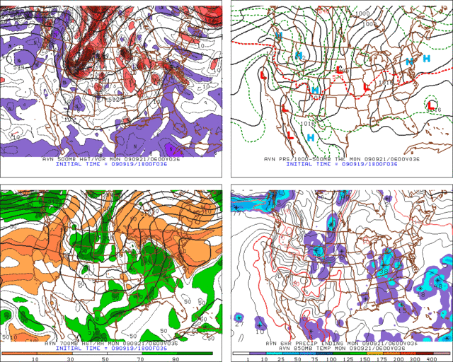
P.S. The shear I don't want to even touch! It's just been a nightmare to try and figure it out since the models can't resolve it down to the mesoscale level we need to make a decent forecast. I mean I'm not gonna give up tryin', but it's just been almost impossible to get it right.
0 likes
-
cycloneye

- Admin
- Posts: 149214
- Age: 69
- Joined: Thu Oct 10, 2002 10:54 am
- Location: San Juan, Puerto Rico
Re: ATL: TROPICAL LOW ex-FRED (ex-07L)
TWOAT
TROPICAL WEATHER OUTLOOK
NWS TPC/NATIONAL HURRICANE CENTER MIAMI FL
800 PM EDT SAT SEP 19 2009
FOR THE NORTH ATLANTIC...CARIBBEAN SEA AND THE GULF OF MEXICO...
A SURFACE TROUGH...ASSOCIATED WITH THE REMNANTS OF FRED...IS
LOCATED ABOUT 450 MILES EAST-NORTHEAST OF THE NORTHWESTERN BAHAMAS.
WHILE UPPER-LEVEL WINDS HAVE BECOME A LITTLE MORE CONDUCIVE FOR
DEVELOPMENT...THE ASSOCIATED SHOWER ACTIVITY IS CURRENTLY
DISORGANIZED. THERE IS A LOW CHANCE...LESS THAN 30 PERCENT...OF
THIS SYSTEM BECOMING A TROPICAL CYCLONE DURING THE NEXT 48 HOURS AS
IT MOVES SLOWLY TOWARD THE WEST-NORTHWEST.
0 likes
-
Blown Away
- S2K Supporter
- Posts: 10253
- Joined: Wed May 26, 2004 6:17 am
Re: ATL: TROPICAL LOW ex-FRED (ex-07L)
I know NWS says WNW, but it appears ex Fred is beginning to drift W or maybe a little S of W. He is almost W of 70W and the convection roach appears to be decreasing.
0 likes
-
carolina_73

- Tropical Storm

- Posts: 148
- Joined: Wed Jul 23, 2008 1:30 am


Re: ATL: TROPICAL LOW ex-FRED (ex-07L)
NWS in Melbourne says that Ex Fred will move NW into the Carolina's.Which is conflicting to what Aric says about a building high pressure which would cause a W or WSW motion.Why such a drastic forecast?
0 likes
-
deltadog03

- Professional-Met
- Posts: 3580
- Joined: Tue Jul 05, 2005 6:16 pm
- Location: Macon, GA

Re: ATL: TROPICAL LOW ex-FRED (ex-07L)
I agree it does not look as bad. I am looking for persistence and not necessarily the size of convection. Let's see if it can hold on.
0 likes
-
ozonepete
- Professional-Met
- Posts: 4743
- Joined: Mon Sep 07, 2009 3:23 pm
- Location: From Ozone Park, NYC / Now in Brooklyn, NY
Re: ATL: TROPICAL LOW ex-FRED (ex-07L)
boca wrote:NWS in Melbourne says that Ex Fred will move NW into the Carolina's.Which is conflicting to what Aric says about a building high pressure which would cause a W or WSW motion.Why such a drastic forecast?
It's interesting that Melbourne now agrees with what the Miami NWS said this afternoon...
Look back about 8 posts to what I answered to the pro met AJC3. The GFS model thinks that the western Atlantic ridge will not be as strong into Florida over the next couple of days as originally forecast. If that happens, it would allow the circulation to move NW instead of west. Also, the center appears to be around 27.5 which is farther north than we thought. If that's true, it will be harder for this system to go west since it will be closer to the northward push of the nose of the ridge and the northward pull of the trough that's lifting out.
0 likes
-
Aric Dunn
- Category 5
- Posts: 21238
- Age: 43
- Joined: Sun Sep 19, 2004 9:58 pm
- Location: Ready for the Chase.
- Contact:
Re: ATL: TROPICAL LOW ex-FRED (ex-07L)
boca wrote:NWS in Melbourne says that Ex Fred will move NW into the Carolina's.Which is conflicting to what Aric says about a building high pressure which would cause a W or WSW motion.Why such a drastic forecast?
well they maybe accounting for the system not moving to fast over the next day or so . but I do not see it moving so slow as the ridge is building and already see west motion as we speak.
0 likes
-
ozonepete
- Professional-Met
- Posts: 4743
- Joined: Mon Sep 07, 2009 3:23 pm
- Location: From Ozone Park, NYC / Now in Brooklyn, NY
Re: ATL: TROPICAL LOW ex-FRED (ex-07L)
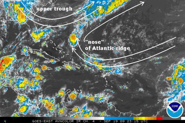
Here's an annotated IR satellite from a little while ago. The nose of that ridge is pushing westward. If the ridge does not keep pushing westward fast enough and the trough moves away quickly enough, the low will move northwestward.
If the trough stays where it is, it will help block the low from going north, and the front edge/nose of the ridge will push it into Florida.
If the trough stays where it is, it will help block the low from going north, and the front edge/nose of the ridge will push it into Florida.
0 likes
-
cycloneye
- Admin
- Posts: 149214
- Age: 69
- Joined: Thu Oct 10, 2002 10:54 am
- Location: San Juan, Puerto Rico
Re: ATL: TROPICAL LOW ex-FRED (ex-07L) - Computer Models
550
WHXX01 KWBC 200039
CHGHUR
TROPICAL CYCLONE GUIDANCE MESSAGE
NWS TPC/NATIONAL HURRICANE CENTER MIAMI FL
0039 UTC SUN SEP 20 2009
DISCLAIMER...NUMERICAL MODELS ARE SUBJECT TO LARGE ERRORS.
PLEASE REFER TO NHC OFFICIAL FORECASTS FOR TROPICAL CYCLONE
AND SUBTROPICAL CYCLONE INFORMATION.
ATLANTIC OBJECTIVE AIDS FOR
DISTURBANCE FRED (AL072009) 20090920 0000 UTC
...00 HRS... ...12 HRS... ...24 HRS. .. ...36 HRS...
090920 0000 090920 1200 090921 0000 090921 1200
LAT LON LAT LON LAT LON LAT LON
BAMS 27.7N 70.2W 28.3N 71.6W 28.9N 72.9W 29.5N 74.5W
BAMD 27.7N 70.2W 27.5N 71.1W 27.5N 72.0W 27.4N 73.2W
BAMM 27.7N 70.2W 28.0N 71.4W 28.2N 72.6W 28.5N 74.0W
LBAR 27.7N 70.2W 28.2N 70.9W 28.9N 71.8W 29.5N 72.9W
SHIP 25KTS 25KTS 28KTS 31KTS
DSHP 25KTS 25KTS 28KTS 31KTS
...48 HRS... ...72 HRS... ...96 HRS. .. ..120 HRS...
090922 0000 090923 0000 090924 0000 090925 0000
LAT LON LAT LON LAT LON LAT LON
BAMS 30.2N 76.1W 31.6N 78.7W 32.1N 79.8W 32.3N 80.7W
BAMD 27.5N 74.5W 27.6N 77.1W 27.3N 78.6W 26.7N 77.9W
BAMM 28.9N 75.5W 29.5N 78.3W 29.7N 79.6W 29.8N 79.9W
LBAR 30.1N 74.0W 31.4N 76.1W 33.9N 75.1W 36.6N 69.4W
SHIP 33KTS 38KTS 41KTS 44KTS
DSHP 33KTS 38KTS 41KTS 44KTS
...INITIAL CONDITIONS...
LATCUR = 27.7N LONCUR = 70.2W DIRCUR = 310DEG SPDCUR = 6KT
LATM12 = 26.6N LONM12 = 69.8W DIRM12 = 322DEG SPDM12 = 6KT
LATM24 = 26.2N LONM24 = 68.2W
WNDCUR = 25KT RMAXWD = 20NM WNDM12 = 30KT
CENPRS = 1012MB OUTPRS = 1015MB OUTRAD = 150NM SDEPTH = M
RD34NE = 0NM RD34SE = 0NM RD34SW = 0NM RD34NW = 0NM
0 likes
-
Aric Dunn
- Category 5
- Posts: 21238
- Age: 43
- Joined: Sun Sep 19, 2004 9:58 pm
- Location: Ready for the Chase.
- Contact:
Re: ATL: TROPICAL LOW ex-FRED (ex-07L)
ozonepete wrote:Here's an annotated IR satellite from a little while ago. The nose of that ridge is pushing westward. If the ridge does not keep pushing westward fast enough and the trough moves away quickly enough, the low will move northwestward.
If the trough stays where it is, it will help block the low from going north, and the front edge/nose of the ridge will push it into Florida.
that is a little off ... the trough pulling is good as it will allow the ridge to build in more to the north keeping it more west..
0 likes
-
cycloneye
- Admin
- Posts: 149214
- Age: 69
- Joined: Thu Oct 10, 2002 10:54 am
- Location: San Juan, Puerto Rico
Re: ATL: TROPICAL LOW ex-FRED (ex-07L)
00 UTC Best Track
Wow,best track has a very long list of plots since it began as a invest and it continues to grow even more.Look at link below.
AL, 07, 2009092000, , BEST, 0, 277N, 702W, 25, 1012, LO
ftp://ftp.tpc.ncep.noaa.gov/atcf/tcweb/ ... 009.invest
Wow,best track has a very long list of plots since it began as a invest and it continues to grow even more.Look at link below.
AL, 07, 2009092000, , BEST, 0, 277N, 702W, 25, 1012, LO
ftp://ftp.tpc.ncep.noaa.gov/atcf/tcweb/ ... 009.invest
0 likes
Who is online
Users browsing this forum: No registered users and 20 guests