ABNT20 KNHC 012331
TWOAT
TROPICAL WEATHER OUTLOOK
NWS TPC/NATIONAL HURRICANE CENTER MIAMI FL
800 PM EDT THU OCT 1 2009
FOR THE NORTH ATLANTIC...CARIBBEAN SEA AND THE GULF OF MEXICO...
A NON-TROPICAL LOW PRESSURE AREA LOCATED NEAR THE CENTRAL AZORES IS
MOVING SLOWLY NORTHWARD. DEVELOPMENT OF THIS SYSTEM IS NOT
ANTICIPATED...AND THERE IS A LOW CHANCE...LESS THAN 30 PERCENT...OF
THIS SYSTEM BECOMING A SUBTROPICAL OR TROPICAL CYCLONE DURING THE
NEXT 48 HOURS.
ELSEWHERE...TROPICAL CYCLONE FORMATION IS NOT EXPECTED DURING THE
NEXT 48 HOURS.
$$
FORECASTER BLAKE
ATL : TROPICAL STORM GRACE
Moderator: S2k Moderators
-
cycloneye

- Admin

- Posts: 149730
- Age: 69
- Joined: Thu Oct 10, 2002 10:54 am
- Location: San Juan, Puerto Rico
Re: ATL : Invest 90L
0 likes
Visit the Caribbean-Central America Weather Thread where you can find at first post web cams,radars
and observations from Caribbean basin members Click Here
and observations from Caribbean basin members Click Here
-
DanieleItalyRm

- Category 1

- Posts: 487
- Age: 40
- Joined: Mon Sep 22, 2008 7:52 am
- Location: Rome - Italy - Mediterranean sea
Re: Re:
littlevince wrote:DanieleItalyRm wrote:The NHC will never give a name to this storm, gust like they did with other storm over the Nord est Atlantic.
If it occured over the nord owest atlantic it would already have a name.
littlevince wrote:I understand your point of view, for me this is some kind of a tropical system too. And there are plenty of interesting storms in the Atlantic and Mediterranean..
I understand your point of view, but the event on Madeira 1993 an Azores 1997 evident not tropical systems.. if your point many tropical cyclones they should be cancelled or not named.
You remember the tropical depression not distructive system (<34 knots) but it have a names.
Ok, this system have cold origin (as many others north atlantic tropical cyclones) but in this moment it's become into tropical system for me.
brunota2003 wrote:This storm does not have any deep convection near the center. Even Vince's convection was deeper than this system.
The thunderstorm convection activity it's evident in the center of this system. Not have deep convection -70 like hurricane cat3 but i don't think the convectio have a limit in a tropical system (-50-/-85°C).
Sorry for my bad english.


Last edited by DanieleItalyRm on Sat Oct 03, 2009 4:52 am, edited 1 time in total.
0 likes
-
cycloneye
- Admin
- Posts: 149730
- Age: 69
- Joined: Thu Oct 10, 2002 10:54 am
- Location: San Juan, Puerto Rico
Re: ATL : Invest 90L
AL, 90, 2009100200, , BEST, 0, 393N, 288W, 45, 984, EX
ftp://ftp.tpc.ncep.noaa.gov/atcf/tcweb/ ... 009.invest
ftp://ftp.tpc.ncep.noaa.gov/atcf/tcweb/ ... 009.invest
0 likes
Visit the Caribbean-Central America Weather Thread where you can find at first post web cams,radars
and observations from Caribbean basin members Click Here
and observations from Caribbean basin members Click Here
-
wxman57

- Moderator-Pro Met

- Posts: 23175
- Age: 68
- Joined: Sat Jun 21, 2003 8:06 pm
- Location: Houston, TX (southwest)
Re: ATL : Invest 90L
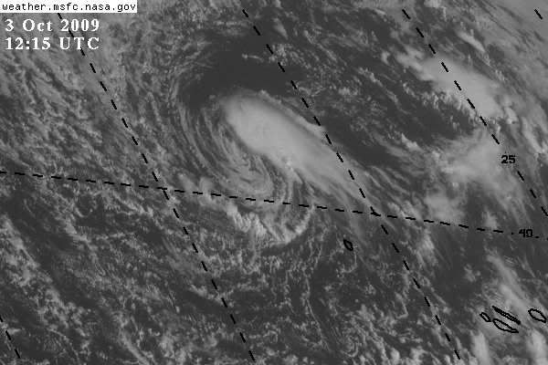
It's certainly much less impressive on satellite now. Though there was convection around the center earlier, it really wasn't very deep. Cloud tops were relatively warm. When you think about it, this low is no more significant than the dozens of lows that pass near the Azores each year. So there isn't much of a reason to name it. It'll be looping around back to the south in a few days where SSTs will be back into the low 20s Celsius. Shear may drop off then, and maybe it'll develop really deep convection around its center. If so, then perhaps it should get a name.
0 likes
-
littlevince

- S2K Supporter

- Posts: 768
- Joined: Fri Oct 21, 2005 10:45 am
- Location: Portugal
Re: ATL : Invest 90L
Yesterday forecaster Tuschy from Estofex (European Storm Forecast Experiment) has write a side note about 90L
--- Side note ---
Since the 28th Sept. 09, a strong cold-core vortex SE of Newfoundland dropped southeastwards for the past few days, straight towards the Azores. A prolonged time atop of increasingly warming SSTs gradually caused a warm-up of the cold low/mid-level cold core. Latest data (1st Oct., 17 UTC) have the center at 38N,29W above SSTs of 22-24°C (slightly positive anomaly compared to the climatology) and forecast track is somewhat erroneous in loops around the Azores during the followinf forecast and thereafter. IR/WV composite reveals an environment, already seen in other subtropical events with high-level (upper troposphere/lower stratosphere) airmass overspreading the center with oscillating convective activity along the center. For now, convection was too weak and short-lived for any classification but a tendency is seen to more persistent convection, wrapping around the center. 12Z sounding of Lajes samples the core of this feature well with a moist and warm troposphere and abundant CAPE release. Synop data has seasonably moist airmass covering the islands with low T-Td spread and 15-20kt southerly winds over the eastern part. This is in line with the QuikScat data, showing strongest winds of 30-35kt to the south of the center, but likely spreading northwards during the forecast period. GFS and ECMWF are in line with the development of a shallow warm core and 12 UTC Met9 data has another strong burst of convection wrapping nearly completely around the center with a thin cirrus canopy. A personal classification would be a ST2.5-3.0 (in respect to the Herbert-Poteat technique) due to the increasing organisation of the convection next to the center and hints on developing banding features next to the low-level circulation center. The National Hurricane Center, responsible for official warnings, recently highlighted the area, however no development of a subtropical cyclone is forecast ( chances less than 30%). Despite the more technical discrepancies, strong wind gusts will probably affect the Azores during the forecast.
http://www.estofex.org/
0 likes
-
littlevince
- S2K Supporter
- Posts: 768
- Joined: Fri Oct 21, 2005 10:45 am
- Location: Portugal

-
HURAKAN

- Professional-Met

- Posts: 46084
- Age: 39
- Joined: Thu May 20, 2004 4:34 pm
- Location: Key West, FL
- Contact:
Not mentioned in the TWO.
861
ABNT20 KNHC 021134
TWOAT
TROPICAL WEATHER OUTLOOK
NWS TPC/NATIONAL HURRICANE CENTER MIAMI FL
800 AM EDT FRI OCT 2 2009
FOR THE NORTH ATLANTIC...CARIBBEAN SEA AND THE GULF OF MEXICO...
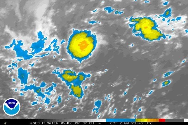
A TROPICAL WAVE LOCATED ABOUT 650 MILES EAST OF THE LESSER ANTILLES
IS MOVING WESTWARD AT ABOUT 10 TO 15 MPH. SHOWERS AND THUNDERSTORMS
ASSOCIATED WITH THIS SYSTEM HAVE DIMINISHED...AND UPPER-LEVEL WINDS
ARE CURRENTLY NOT CONDUCIVE FOR DEVELOPMENT. THERE IS A LOW CHANCE
...LESS THAN 30 PERCENT...OF THIS SYSTEM BECOMING A TROPICAL CYCLONE
DURING THE NEXT 48 HOURS.
ELSEWHERE...TROPICAL CYCLONE FORMATION IS NOT EXPECTED DURING THE
NEXT 48 HOURS.
$$
FORECASTER ROBERTS/BRENNAN
861
ABNT20 KNHC 021134
TWOAT
TROPICAL WEATHER OUTLOOK
NWS TPC/NATIONAL HURRICANE CENTER MIAMI FL
800 AM EDT FRI OCT 2 2009
FOR THE NORTH ATLANTIC...CARIBBEAN SEA AND THE GULF OF MEXICO...
A TROPICAL WAVE LOCATED ABOUT 650 MILES EAST OF THE LESSER ANTILLES
IS MOVING WESTWARD AT ABOUT 10 TO 15 MPH. SHOWERS AND THUNDERSTORMS
ASSOCIATED WITH THIS SYSTEM HAVE DIMINISHED...AND UPPER-LEVEL WINDS
ARE CURRENTLY NOT CONDUCIVE FOR DEVELOPMENT. THERE IS A LOW CHANCE
...LESS THAN 30 PERCENT...OF THIS SYSTEM BECOMING A TROPICAL CYCLONE
DURING THE NEXT 48 HOURS.
ELSEWHERE...TROPICAL CYCLONE FORMATION IS NOT EXPECTED DURING THE
NEXT 48 HOURS.
$$
FORECASTER ROBERTS/BRENNAN
0 likes
-
HURAKAN
- Professional-Met
- Posts: 46084
- Age: 39
- Joined: Thu May 20, 2004 4:34 pm
- Location: Key West, FL
- Contact:
NHC_ATCF
invest_DEACTIVATE_al902009.ren
FSTDA
R
U
040
010
0000
200910021142
NONE
NOTIFY=ATRP
END
INVEST, AL, L, , , , , 90, 2009, DB, O, 2009100112, 9999999999, , , , , , METWATCH, , AL902009
AL, 90, 2009093012, , BEST, 0, 388N, 346W, 40, 995, EX, 34, NEQ, 30, 30, 40, 30,
AL, 90, 2009093018, , BEST, 0, 374N, 331W, 40, 995, EX, 34, NEQ, 30, 40, 40, 30,
AL, 90, 2009100100, , BEST, 0, 367N, 316W, 40, 995, EX, 34, NEQ, 30, 40, 40, 30,
AL, 90, 2009100106, , BEST, 0, 369N, 298W, 40, 995, EX, 34, NEQ, 30, 40, 40, 30,
AL, 90, 2009100112, , BEST, 0, 377N, 290W, 40, 995, EX, 34, NEQ, 30, 40, 40, 30, 1008, 350, 0, 0, 0, L, 0, , 0, 0, INVEST, D,
AL, 90, 2009100118, , BEST, 0, 386N, 285W, 45, 984, EX, 34, NEQ, 30, 40, 40, 30, 1008, 350, 0, 0, 0, L, 0, , 0, 0, INVEST, D,
AL, 90, 2009100200, , BEST, 0, 393N, 288W, 45, 984, EX, 34, NEQ, 30, 40, 40, 30, 1008, 350, 0, 0, 0, L, 0, , 0, 0, INVEST, D,
0 likes
-
somethingfunny

- ChatStaff

- Posts: 3926
- Age: 37
- Joined: Thu May 31, 2007 10:30 pm
- Location: McKinney, Texas
-
tolakram
- Admin
- Posts: 20186
- Age: 62
- Joined: Sun Aug 27, 2006 8:23 pm
- Location: Florence, KY (name is Mark)
Re: ATL : Invest 90L

0 likes
M a r k
- - - - -
Join us in chat: Storm2K Chatroom Invite. Android and IOS apps also available.
The posts in this forum are NOT official forecasts and should not be used as such. Posts are NOT endorsed by any professional institution or STORM2K.org. For official information and forecasts, please refer to NHC and NWS products.
-
DanieleItalyRm
- Category 1
- Posts: 487
- Age: 40
- Joined: Mon Sep 22, 2008 7:52 am
- Location: Rome - Italy - Mediterranean sea
Today - wind 30-35 knots:

Evident like at more tropical depression/storm of this type :


In this moment increase the convection in the center..


Evident like at more tropical depression/storm of this type :


In this moment increase the convection in the center..


Last edited by DanieleItalyRm on Sat Oct 03, 2009 1:46 am, edited 1 time in total.
0 likes
-
DanieleItalyRm
- Category 1
- Posts: 487
- Age: 40
- Joined: Mon Sep 22, 2008 7:52 am
- Location: Rome - Italy - Mediterranean sea


Re: ATL : Invest 90L
Admit that PSU phase diagram may show shallow warm core:

However the cold 21-22 C water, and the more recent QuikSCAT I can find (while old, the one you posted above is even older, and there is none centered on system since no longer an invest) shows winds <30 kt:

Satellite also suggests northeasterly shear resulting in an intermittently exposed center. Definitely not a Vince, and the lack of posts show that for most classification of this would be mostly for academic interest (or to raise one's forecast numbers ).
).
supercane
However the cold 21-22 C water, and the more recent QuikSCAT I can find (while old, the one you posted above is even older, and there is none centered on system since no longer an invest) shows winds <30 kt:
Satellite also suggests northeasterly shear resulting in an intermittently exposed center. Definitely not a Vince, and the lack of posts show that for most classification of this would be mostly for academic interest (or to raise one's forecast numbers
supercane
0 likes
-
DanieleItalyRm
- Category 1
- Posts: 487
- Age: 40
- Joined: Mon Sep 22, 2008 7:52 am
- Location: Rome - Italy - Mediterranean sea

-
DanieleItalyRm
- Category 1
- Posts: 487
- Age: 40
- Joined: Mon Sep 22, 2008 7:52 am
- Location: Rome - Italy - Mediterranean sea


-
pepeavilenho
- Tropical Storm

- Posts: 171
- Joined: Thu Jul 09, 2009 12:01 pm


-
DanieleItalyRm
- Category 1
- Posts: 487
- Age: 40
- Joined: Mon Sep 22, 2008 7:52 am
- Location: Rome - Italy - Mediterranean sea
Look the outflow today.. egual at many tropical depression.
90L Invest - 35 knots


Example: tropical storm Franklin

90L Invest - 35 knots


Example: tropical storm Franklin

Last edited by DanieleItalyRm on Sat Oct 03, 2009 2:09 pm, edited 1 time in total.
0 likes
Who is online
Users browsing this forum: No registered users and 34 guests