I've had .75" up here near The Woodlands.
I'm not too worried about the rain to the SW - it seems to be moving due east and will mostly miss me to the south. My concern is with possible redevelopment later-on...
SE TX/SW LA weather: Much cooler and WET after Tuesday
Moderator: S2k Moderators
Forum rules

The posts in this forum are NOT official forecast and should not be used as such. They are just the opinion of the poster and may or may not be backed by sound meteorological data. They are NOT endorsed by any professional institution or STORM2K.
-
srainhoutx

- S2K Supporter

- Posts: 6919
- Age: 68
- Joined: Sun Jan 14, 2007 11:34 am
- Location: Haywood County, NC
- Contact:
Re: SE TX/SW LA weather: Heavy Rainfall Possible
Yeah Jason, the area N of Austin is slowy back building and drifting SE. Just in time for the s/w later today.
0 likes
Carla/Alicia/Jerry(In The Eye)/Michelle/Charley/Ivan/Dennis/Katrina/Rita/Wilma/Ike/Harvey
Member: National Weather Association
Wx Infinity Forums
http://wxinfinity.com/index.php
Facebook.com/WeatherInfinity
Twitter @WeatherInfinity
Member: National Weather Association
Wx Infinity Forums
http://wxinfinity.com/index.php
Facebook.com/WeatherInfinity
Twitter @WeatherInfinity
-
srainhoutx
- S2K Supporter
- Posts: 6919
- Age: 68
- Joined: Sun Jan 14, 2007 11:34 am
- Location: Haywood County, NC
- Contact:
Re: SE TX/SW LA weather: Heavy Rainfall Possible
Looking at radar from Austin, you can already see the what may be another Meso scale event unfolding as another shortwave approaches from just W of San Antonio. Looking upstream, there is an area of increasing Upper energy moving across N MX. More fuel for the fire.
http://radar.weather.gov/radar.php?rid= ... 1&loop=yes
http://radar.weather.gov/radar.php?rid= ... 1&loop=yes
0 likes
Carla/Alicia/Jerry(In The Eye)/Michelle/Charley/Ivan/Dennis/Katrina/Rita/Wilma/Ike/Harvey
Member: National Weather Association
Wx Infinity Forums
http://wxinfinity.com/index.php
Facebook.com/WeatherInfinity
Twitter @WeatherInfinity
Member: National Weather Association
Wx Infinity Forums
http://wxinfinity.com/index.php
Facebook.com/WeatherInfinity
Twitter @WeatherInfinity
-
srainhoutx
- S2K Supporter
- Posts: 6919
- Age: 68
- Joined: Sun Jan 14, 2007 11:34 am
- Location: Haywood County, NC
- Contact:
Re: SE TX/SW LA weather: Heavy Rainfall Possible
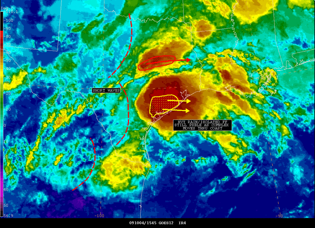
SATELLITE PRECIPITATION ESTIMATES..DATE/TIME 10/04/09 1622Z
SATELLITE ANALYSIS BRANCH/NESDIS---NPPU---TEL.301-763-8678
LATEST DATA USED: GOES-12 1615Z KUSSELSON
.
LOCATION...SOUTHEAST TEXAS...
.
ATTN WFOS...HGX...CRP...
ATTN RFCS...WGRFC...
.
EVENT...WITH MERGERS COMPLETE...COMPLEX MOVING ALONG...STILL FF POTENTIAL
FROM EXCESSIVE MOISTURE AND TRAINING CELLS...
.
SATELLITE ANALYSIS AND TRENDS...WITH THE SUCCESSFUL MERGER OF COMPLEXES
COMPLETE...MCS MOVING ALONG EAST ALONG AND JUST NORTH OF HIGHEST PWAT
MOISTURE. 2.0"-2.5" PWAT VALUES AND SOME TRAINING CELLS CAN STILL RESULT
IN HIGH RAIN AMOUNTS OVER A SHORT TIME FRAME AS COMPLEX MOVES EAST TO
THE COAST. CONCERN AREAS CALHOUN TO WHARTON TO FT BEND AND AT LEAST THE
SOUTHERN SUBURBS OF HOUSTON AND S GALVESTON COUNTY TO MATAGORDA/BRAZORIA
COUNTY AT THE COAST. MOISTURE WILL NOT BE GOING AWAY ANYTIME SOON SO
WILL HAVE TO KEEP AN EYE ON ANY POSSIBLE DEVELOPMENT LATER ON...BUT
THINGS SHOULD BE PRETTY STABLE RIGHT BEHIND COMPLEX AS IT CONTINUES EAST.
0 likes
Carla/Alicia/Jerry(In The Eye)/Michelle/Charley/Ivan/Dennis/Katrina/Rita/Wilma/Ike/Harvey
Member: National Weather Association
Wx Infinity Forums
http://wxinfinity.com/index.php
Facebook.com/WeatherInfinity
Twitter @WeatherInfinity
Member: National Weather Association
Wx Infinity Forums
http://wxinfinity.com/index.php
Facebook.com/WeatherInfinity
Twitter @WeatherInfinity

Re: SE TX/SW LA weather: Heavy Rainfall Possible
Quite a rainy day today. I heard a couple thunder earlier this morning. I wonder if more rain will come.
0 likes
-
southerngale

- Retired Staff

- Posts: 27418
- Joined: Thu Oct 10, 2002 1:27 am
- Location: Southeast Texas (Beaumont area)
Re: SE TX/SW LA weather: Heavy Rainfall Possible
Ptarmigan wrote:Quite a rainy day today. I heard a couple thunder earlier this morning. I wonder if more rain will come.
I wonder if any rain will come over here. It looks like the little bit I got yesterday may be it. I expected more from a 100% chance of heavy rain.
I should know better. It's those 20% - 30% days that you have to look out for. hehe
0 likes
Please support Storm2k by making a donation today. It is greatly appreciated! Click here: 
 my Cowboys my Rockets my Astros
my Cowboys my Rockets my Astros-
jasons2k

- Storm2k Executive

- Posts: 8290
- Age: 52
- Joined: Wed Jul 06, 2005 12:32 pm
- Location: The Woodlands, TX
Re:
JenBayles wrote:The past hour has brought more sunlight through the clouds. Wondering if that will help fuel the line of storms to our NW?
I think so Jen. And that line is now backbuilding as far south as I-10...
0 likes
-
JenBayles

- Category 5

- Posts: 3461
- Age: 63
- Joined: Tue Aug 26, 2003 3:27 pm
- Location: Houston, TX
- Contact:
Thanks for the confirmation - I think! One of my poor dogs gets terrified in thunderstorms. Once in a while we have time to tranquilize her a bit before hand, but hate to do it. She was doing so much better before the flooding storms in April. Now I think she'll never get over it.
Anyway, being only 3:30 now, looks like plenty of time for heating instability. What a weird day!
Anyway, being only 3:30 now, looks like plenty of time for heating instability. What a weird day!
0 likes

-
srainhoutx
- S2K Supporter
- Posts: 6919
- Age: 68
- Joined: Sun Jan 14, 2007 11:34 am
- Location: Haywood County, NC
- Contact:
Re: SE TX/SW LA weather: Heavy Rainfall Possible
SATELLITE PRECIPITATION ESTIMATES..DATE/TIME 10/04/09 2120Z
SATELLITE ANALYSIS BRANCH/NESDIS---NPPU---TEL.301-763-8678
LATEST DATA USED: GOES-12 2045Z GOES-11 2100Z ALS
HYDROESTIMATOR THROUGH 2100Z
.
LOCATION...TEXAS...
.
ATTN WFOS...HGX...EWX...
ATTN RFCS...WGRFC...
.
EVENT...ISOLATED COLD TOPPED CONVECTION
.
SATELLITE ANALYSIS AND TRENDS...IMAGERY INDICATES CLOUDTOPS HAVE COOLED
RAPIDLY TO -73C IN WESTERN WASHINGTON COUNTY. GOES SOUNDER PWS ARE 2.3-
2.5 IN SOUTH TEXAS JUST TO THE SOUTH OF THE DEVELOPING CONVECTION AND THE
CIRA ANOMALY PRODUCT INDICATED PWS OF 200% OF NORMAL . HYDROESTIMATES OF
1 INCH OVER THE PAST HOUR ARE INDICATED. WOULD EXPECT CONTINUED EASTWARD
MOVEMENT SO AMOUNTS SHOULD NOT BECOME EXCESSIVE.
0 likes
Carla/Alicia/Jerry(In The Eye)/Michelle/Charley/Ivan/Dennis/Katrina/Rita/Wilma/Ike/Harvey
Member: National Weather Association
Wx Infinity Forums
http://wxinfinity.com/index.php
Facebook.com/WeatherInfinity
Twitter @WeatherInfinity
Member: National Weather Association
Wx Infinity Forums
http://wxinfinity.com/index.php
Facebook.com/WeatherInfinity
Twitter @WeatherInfinity
-
srainhoutx
- S2K Supporter
- Posts: 6919
- Age: 68
- Joined: Sun Jan 14, 2007 11:34 am
- Location: Haywood County, NC
- Contact:
Re: SE TX/SW LA weather: Heavy Rainfall Possible
SATELLITE PRECIPITATION ESTIMATES..DATE/TIME 10/04/09 2311Z
SATELLITE ANALYSIS BRANCH/NESDIS---NPPU---TEL.301-763-8678
LATEST DATA USED: GOES-12 2245Z ALS
HYDROESTIMATOR THOUGHT 2245Z
LOCATION...TEXAS...
.
ATTN WFOS...HGX...EWX...
ATTN RFCS...WGRFC...
.
EVENT...BAND OF CONVECTION
.
SATELLITE ANALYSIS AND TRENDS...CONVECTION HAS CONTINUED TO REDEVELOP
WITH THE COLDEST TOPS FROM COLORADO COUNTY EASTNORTHEASTWARD TO
SOUTHERN MONTGOMERY COUNTY. GOES OBJECTIVE ANALYSIS IS NOW PICKING UP
A WELL DEFINED MOISTURE CONVERGENCE AXIS AND VISIBLE IMAGERY SUPPORTS
THIS. LATEST GOES SOUNDER PWS ARE 2.3-2.4 JUST TO THE SOUTH. SLOW
EASTSOUTHEAST TRANSLATION OF THE LINE CONTINUES TO OCCUR. HYDROESTIMATOR
IS INDICATING TOTALS OF TO 2 INCHES FROM EASTERN AUSTIN COUNTY THROUGH
WALLER COUNTY INTO SOUTHERN MONTGOMERY/NORTHERN HARRIS COUNTY.
0 likes
Carla/Alicia/Jerry(In The Eye)/Michelle/Charley/Ivan/Dennis/Katrina/Rita/Wilma/Ike/Harvey
Member: National Weather Association
Wx Infinity Forums
http://wxinfinity.com/index.php
Facebook.com/WeatherInfinity
Twitter @WeatherInfinity
Member: National Weather Association
Wx Infinity Forums
http://wxinfinity.com/index.php
Facebook.com/WeatherInfinity
Twitter @WeatherInfinity
-
southerngale
- Retired Staff
- Posts: 27418
- Joined: Thu Oct 10, 2002 1:27 am
- Location: Southeast Texas (Beaumont area)
100% chance of rain today and not a drop! I wonder how many people canceled plans and rescheduled events. And the high chances for the rest of the week disappeared as well.
I think I'm done looking at forecasts. I'm just going to pay attention to nowcasts from now on.
Oh, and the Cowboys played like a bunch of sissies today. PATHETIC!

I think I'm done looking at forecasts. I'm just going to pay attention to nowcasts from now on.
Oh, and the Cowboys played like a bunch of sissies today. PATHETIC!
0 likes
Please support Storm2k by making a donation today. It is greatly appreciated! Click here:
my Cowboys my Rockets my Astros
my Cowboys my Rockets my Astros-
vbhoutex

- Storm2k Executive
- Posts: 29149
- Age: 74
- Joined: Wed Oct 09, 2002 11:31 pm
- Location: Cypress, TX
- Contact:
Re: SE TX/SW LA weather: Heavy Rainfall Possible
srainhoutx wrote:SATELLITE PRECIPITATION ESTIMATES..DATE/TIME 10/04/09 2311Z
SATELLITE ANALYSIS BRANCH/NESDIS---NPPU---TEL.301-763-8678
LATEST DATA USED: GOES-12 2245Z ALS
HYDROESTIMATOR THOUGHT 2245Z
LOCATION...TEXAS...
.
ATTN WFOS...HGX...EWX...
ATTN RFCS...WGRFC...
.
EVENT...BAND OF CONVECTION
.
SATELLITE ANALYSIS AND TRENDS...CONVECTION HAS CONTINUED TO REDEVELOP
WITH THE COLDEST TOPS FROM COLORADO COUNTY EASTNORTHEASTWARD TO
SOUTHERN MONTGOMERY COUNTY. GOES OBJECTIVE ANALYSIS IS NOW PICKING UP
A WELL DEFINED MOISTURE CONVERGENCE AXIS AND VISIBLE IMAGERY SUPPORTS
THIS. LATEST GOES SOUNDER PWS ARE 2.3-2.4 JUST TO THE SOUTH. SLOW
EASTSOUTHEAST TRANSLATION OF THE LINE CONTINUES TO OCCUR. HYDROESTIMATOR
IS INDICATING TOTALS OF TO 2 INCHES FROM EASTERN AUSTIN COUNTY THROUGH
WALLER COUNTY INTO SOUTHERN MONTGOMERY/NORTHERN HARRIS COUNTY.
And it even looked good on radar for some heavy rains. All I got was some thunder and some spits. I think Jen has increased the dome size.
0 likes
-
srainhoutx
- S2K Supporter
- Posts: 6919
- Age: 68
- Joined: Sun Jan 14, 2007 11:34 am
- Location: Haywood County, NC
- Contact:
Totaled about 1.5 inches with the event. Last evenings thunder shower helped up the totals. All in all, not too shabby. Now attention turns to a rather strong Cold Front and possibly some severe weather aas it approaches on Friday. Also the 12Z ECMWF showed another EPAC system near the Baja in a little over a week. ~ Argh~
0 likes
Carla/Alicia/Jerry(In The Eye)/Michelle/Charley/Ivan/Dennis/Katrina/Rita/Wilma/Ike/Harvey
Member: National Weather Association
Wx Infinity Forums
http://wxinfinity.com/index.php
Facebook.com/WeatherInfinity
Twitter @WeatherInfinity
Member: National Weather Association
Wx Infinity Forums
http://wxinfinity.com/index.php
Facebook.com/WeatherInfinity
Twitter @WeatherInfinity
-
srainhoutx
- S2K Supporter
- Posts: 6919
- Age: 68
- Joined: Sun Jan 14, 2007 11:34 am
- Location: Haywood County, NC
- Contact:
Re: SE TX/SW LA weather: Heavy Rainfall Possible
Jeff's e-mail this morning...
Extremely warm and muggy weather on tap through Friday before the arrival of a decent Fall cold front to bring relief to this oppressive humidity.
Dewpoints running at astounding upper 70’s to lower 80’s this morning…more expected in July than early October. Mid level ridge is nosing into the area from the south helping to put a lid on any deep convection in this extremely moist air mass. Frontal boundary to our north will sag southward this evening after an uncomfortable day with heat index values rising into the low 100’s. Boundary will stall north of the I-10 corridor with at least a slight chance of scattered showers and thunderstorms this afternoon and overnight along and behind this feature.
Front returns northward on Wednesday with muggy air mass remaining in place. Next storm system approaches late Thursday-early Saturday. Large 1035-1040mb NW Canadian high will slide SE allowing a strong frontal boundary to reach TX late Thursday. GFS is showing a faster frontal passage, but prefer to go with the slower solution and have the front crossing the area Friday evening/night. Significant lift, low level convergence, and deep moisture all point to a line of strong thunderstorms along the boundary. Heavy rainfall appears likely, but the system should be progressive enough to negate any significant flooding issues.
Strong cold air advection onsets with the frontal passage with dewpoints tanking into the 40’s and gusty north winds. Given the high heat and humidity of this week…it will feel very different post front. Will show lows in the 60’s for Saturday morning and highs Saturday only in the middle 70’s. Feel Sunday morning may see several locations fall into the 50’s under clear skies and light winds.
0 likes
Carla/Alicia/Jerry(In The Eye)/Michelle/Charley/Ivan/Dennis/Katrina/Rita/Wilma/Ike/Harvey
Member: National Weather Association
Wx Infinity Forums
http://wxinfinity.com/index.php
Facebook.com/WeatherInfinity
Twitter @WeatherInfinity
Member: National Weather Association
Wx Infinity Forums
http://wxinfinity.com/index.php
Facebook.com/WeatherInfinity
Twitter @WeatherInfinity

-
srainhoutx
- S2K Supporter
- Posts: 6919
- Age: 68
- Joined: Sun Jan 14, 2007 11:34 am
- Location: Haywood County, NC
- Contact:
Re: SE TX/SW LA weather: Fall pattern
Well another EPAC system has been modeled rather consistantly by the ECMWF. One has to wonder with another strong frontal boundry stalling in the NW GOM, if we will see a redux of Olaf...

0 likes
Carla/Alicia/Jerry(In The Eye)/Michelle/Charley/Ivan/Dennis/Katrina/Rita/Wilma/Ike/Harvey
Member: National Weather Association
Wx Infinity Forums
http://wxinfinity.com/index.php
Facebook.com/WeatherInfinity
Twitter @WeatherInfinity
Member: National Weather Association
Wx Infinity Forums
http://wxinfinity.com/index.php
Facebook.com/WeatherInfinity
Twitter @WeatherInfinity
-
southerngale
- Retired Staff
- Posts: 27418
- Joined: Thu Oct 10, 2002 1:27 am
- Location: Southeast Texas (Beaumont area)
Well, after complaining about no rain a few days ago, today I dumped my rain gauge and it was halfway between 1.5" and 1.75" so I guess about 1.6 something. I assume that some of it had evaporated. Anyway, late Sunday night into overnight, after all of the rain (that missed me) had pretty much cleared, an odd little line developed and trained from west to east from the Houston area into Louisiana. It was over me for a while and it rained really hard.
Anyway, maybe whining actually does work.
Edit: I just checked NWS and the airport recorded 2.64" overnight Sunday night, with 2.28" of that coming in less than one hour.
Anyway, maybe whining actually does work.
Edit: I just checked NWS and the airport recorded 2.64" overnight Sunday night, with 2.28" of that coming in less than one hour.
0 likes
Please support Storm2k by making a donation today. It is greatly appreciated! Click here:
my Cowboys my Rockets my Astros
my Cowboys my Rockets my Astros