BEGIN
NHC_ATCF
invest_al912009.invest
FSTDA
R
U
040
010
0000
200910050321
NONE
NOTIFY=ATRP
END
INVEST, AL, L, , , , , 91, 2009, DB, O, 2009100500, 9999999999, , , , , , METWATCH, , AL912009
AL, 91, 2009100400, , BEST, 0, 102N, 368W, 25, 1009, DB, 0, , 0, 0, 0, 0,
AL, 91, 2009100406, , BEST, 0, 104N, 382W, 25, 1009, DB, 0, , 0, 0, 0, 0,
AL, 91, 2009100412, , BEST, 0, 106N, 396W, 25, 1009, DB, 0, , 0, 0, 0, 0,
AL, 91, 2009100418, , BEST, 0, 109N, 413W, 25, 1009, DB, 0, , 0, 0, 0, 0,
AL, 91, 2009100500, , BEST, 0, 112N, 429W, 25, 1009, DB
ftp://ftp.tpc.ncep.noaa.gov/atcf/tcweb/ ... 009.invest
ATL: TROPICAL DEPRESSION HENRI (10L)
Moderator: S2k Moderators
-
cycloneye

- Admin

- Posts: 149514
- Age: 69
- Joined: Thu Oct 10, 2002 10:54 am
- Location: San Juan, Puerto Rico
ATL: TROPICAL DEPRESSION HENRI (10L)
0 likes
Visit the Caribbean-Central America Weather Thread where you can find at first post web cams,radars
and observations from Caribbean basin members Click Here
and observations from Caribbean basin members Click Here
-
HURAKAN

- Professional-Met

- Posts: 46084
- Age: 39
- Joined: Thu May 20, 2004 4:34 pm
- Location: Key West, FL
- Contact:
ATL: TROPICAL DEPRESSION HENRI - Models
936
WHXX01 KWBC 050331
CHGHUR
TROPICAL CYCLONE GUIDANCE MESSAGE
NWS TPC/NATIONAL HURRICANE CENTER MIAMI FL
0331 UTC MON OCT 5 2009
DISCLAIMER...NUMERICAL MODELS ARE SUBJECT TO LARGE ERRORS.
PLEASE REFER TO NHC OFFICIAL FORECASTS FOR TROPICAL CYCLONE
AND SUBTROPICAL CYCLONE INFORMATION.
ATLANTIC OBJECTIVE AIDS FOR
DISTURBANCE INVEST (AL912009) 20091005 0000 UTC
...00 HRS... ...12 HRS... ...24 HRS. .. ...36 HRS...
091005 0000 091005 1200 091006 0000 091006 1200
LAT LON LAT LON LAT LON LAT LON
BAMS 11.2N 42.9W 12.9N 46.1W 14.7N 49.3W 16.4N 52.8W
BAMD 11.2N 42.9W 12.5N 45.8W 14.2N 48.3W 16.0N 50.7W
BAMM 11.2N 42.9W 12.4N 46.0W 13.9N 48.8W 15.3N 51.7W
LBAR 11.2N 42.9W 12.3N 45.9W 13.6N 48.9W 14.9N 51.8W
SHIP 25KTS 28KTS 35KTS 42KTS
DSHP 25KTS 28KTS 35KTS 42KTS
...48 HRS... ...72 HRS... ...96 HRS. .. ..120 HRS...
091007 0000 091008 0000 091009 0000 091010 0000
LAT LON LAT LON LAT LON LAT LON
BAMS 18.2N 55.7W 20.1N 60.3W 20.4N 64.1W 18.7N 68.3W
BAMD 18.0N 52.5W 21.2N 54.1W 21.8N 54.7W 19.6N 54.9W
BAMM 16.8N 54.2W 18.3N 58.4W 18.4N 63.7W 17.0N 69.2W
LBAR 16.9N 54.4W 20.4N 57.1W 23.0N 55.9W 21.3N 50.5W
SHIP 50KTS 56KTS 60KTS 68KTS
DSHP 50KTS 56KTS 60KTS 68KTS
...INITIAL CONDITIONS...
LATCUR = 11.2N LONCUR = 42.9W DIRCUR = 280DEG SPDCUR = 16KT
LATM12 = 10.6N LONM12 = 39.6W DIRM12 = 280DEG SPDM12 = 15KT
LATM24 = 10.2N LONM24 = 36.8W
WNDCUR = 25KT RMAXWD = 30NM WNDM12 = 25KT
CENPRS = 1009MB OUTPRS = 1011MB OUTRAD = 175NM SDEPTH = M
RD34NE = 0NM RD34SE = 0NM RD34SW = 0NM RD34NW = 0NM
$$
NNNN
0 likes
-
cycloneye
- Admin
- Posts: 149514
- Age: 69
- Joined: Thu Oct 10, 2002 10:54 am
- Location: San Juan, Puerto Rico
Re: ATL: Invest 91L - Models
First tracks for 91L.It looks like a good high builds bending it west.

0 likes
Visit the Caribbean-Central America Weather Thread where you can find at first post web cams,radars
and observations from Caribbean basin members Click Here
and observations from Caribbean basin members Click Here

Re: ATL : INVEST 91L
Other then Ana the Caribbean has been untouched by a system this year.Every thing else has recurved,but now the high will keep it west.
0 likes
-
Gustywind

- Category 5

- Posts: 12334
- Joined: Mon Sep 03, 2007 7:29 am
- Location: Baie-Mahault, GUADELOUPE
Invest #91  http://tropics.hamweather.com/2009/atla ... est91.html
Tropical Disturbance Summary
Invest #91
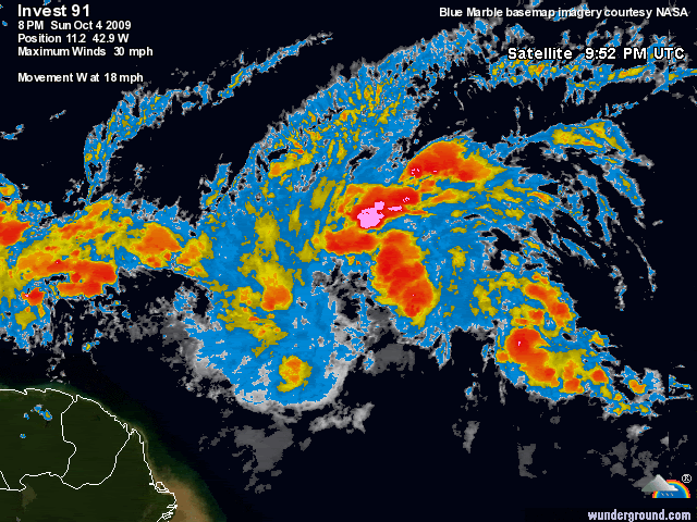
Location: Central Atlantic Lat: 11.2N Lon: 42.9W Moving: W 18 mph (16 kts) Pressure: 29.8 in (1009 mb)
Invest #91 Track History
Date Position Moving Speed Pressure Winds
(UTC) Lat Lon mph (kts) in (mb) mph (kts)
0000 MON OCT 05 11.2N 42.9W W 18 (16) 29.8 (1009) 29 (25)
1800 SUN OCT 04 10.9N 41.3W W 20 (17) 29.8 (1009) 29 (25)
1200 SUN OCT 04 10.6N 39.6W W 16 (14) 29.8 (1009) 29 (25)
0600 SUN OCT 04 10.4N 38.2W W 16 (14) 29.8 (1009) 29 (25)
0000 SUN OCT 04 10.2N 36.8W - - 29.8 (1009) 29 (25)
Tropical Disturbance Summary
Invest #91
Location: Central Atlantic Lat: 11.2N Lon: 42.9W Moving: W 18 mph (16 kts) Pressure: 29.8 in (1009 mb)
Invest #91 Track History
Date Position Moving Speed Pressure Winds
(UTC) Lat Lon mph (kts) in (mb) mph (kts)
0000 MON OCT 05 11.2N 42.9W W 18 (16) 29.8 (1009) 29 (25)
1800 SUN OCT 04 10.9N 41.3W W 20 (17) 29.8 (1009) 29 (25)
1200 SUN OCT 04 10.6N 39.6W W 16 (14) 29.8 (1009) 29 (25)
0600 SUN OCT 04 10.4N 38.2W W 16 (14) 29.8 (1009) 29 (25)
0000 SUN OCT 04 10.2N 36.8W - - 29.8 (1009) 29 (25)
0 likes
-
cycloneye
- Admin
- Posts: 149514
- Age: 69
- Joined: Thu Oct 10, 2002 10:54 am
- Location: San Juan, Puerto Rico
Re: ATL: Invest 91L - Models
I dont know what happened with BAMD and its track. 
0 likes
Visit the Caribbean-Central America Weather Thread where you can find at first post web cams,radars
and observations from Caribbean basin members Click Here
and observations from Caribbean basin members Click Here

Re: ATL: Invest 91L - Models
The posts in this forum are NOT official forecast and should not be used as such. They are just the opinion of the poster and may or may not be backed by sound meteorological data. They are NOT endorsed by any professional institution or storm2k.org. For official information, please refer to the NHC and NWS products.
So SHIP has Hurricane Henri in a few days, after Grace everything is possible. I don't think that conditions will be that favorable but if the High builds it could have a good chance for moderate strengthening, maybe into a 55 kt TS.
So SHIP has Hurricane Henri in a few days, after Grace everything is possible. I don't think that conditions will be that favorable but if the High builds it could have a good chance for moderate strengthening, maybe into a 55 kt TS.
0 likes
Re: ATL: Invest 91L - Models
Cycloneye I know what you'll be doing this week if the track verifies.
0 likes
Re: ATL : INVEST 91L
The envelope on 91L is so big it might take a couple of days it organize itself to depresson status.
0 likes
-
cycloneye
- Admin
- Posts: 149514
- Age: 69
- Joined: Thu Oct 10, 2002 10:54 am
- Location: San Juan, Puerto Rico
Re: ATL: Invest 91L - Models
boca wrote:Cycloneye I know what you'll be doing this week if the track verifies.
Well,is early to know if PR will be impacted.I think we will know more about the future track in the next 24 to 48 hours.
0 likes
Visit the Caribbean-Central America Weather Thread where you can find at first post web cams,radars
and observations from Caribbean basin members Click Here
and observations from Caribbean basin members Click Here

-
hurricanetrack

- HurricaneTrack.com
- Posts: 1781
- Joined: Tue Dec 02, 2003 10:46 pm
- Location: Wilmington, NC
- Contact:
Very concerned about why the globals dump this and all will be well with the world. Some can say it is simply "2009" and that's why. But tropical cyclones and their embronic fledglings have no memory of what was before them. If conditions allow, we should see development. I guess conditions just might not be favorable and thus the globals do very little with this feature. Hard to understand it all, but there it is, looking rather healthy tonight. We shall see.
0 likes
Re:
hurricanetrack wrote:Very concerned about why the globals dump this and all will be well with the world. Some can say it is simply "2009" and that's why. But tropical cyclones and their embronic fledglings have no memory of what was before them. If conditions allow, we should see development. I guess conditions just might not be favorable and thus the globals do very little with this feature. Hard to understand it all, but there it is, looking rather healthy tonight. We shall see.
Maybe it could be shear thats kills it.Who knows.
0 likes

-
cycloneye
- Admin
- Posts: 149514
- Age: 69
- Joined: Thu Oct 10, 2002 10:54 am
- Location: San Juan, Puerto Rico
Re: ATL : INVEST 91L
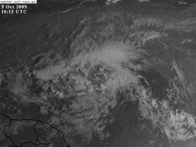
There is some kind of rotation but is still disorganized.

0 likes
Visit the Caribbean-Central America Weather Thread where you can find at first post web cams,radars
and observations from Caribbean basin members Click Here
and observations from Caribbean basin members Click Here
Who is online
Users browsing this forum: No registered users and 25 guests