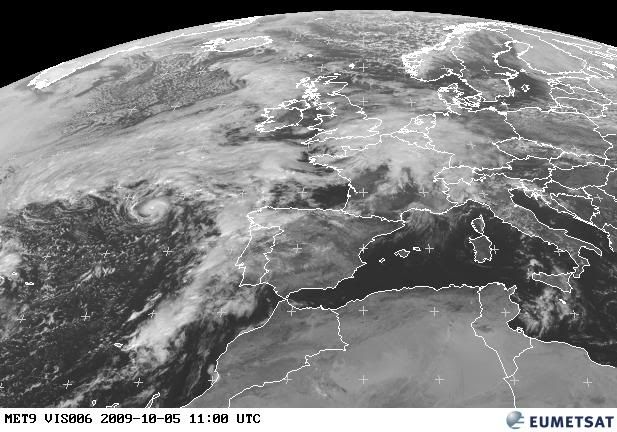
ATL : TROPICAL STORM GRACE
Moderator: S2k Moderators


-
leaf blower

- Tropical Low

- Posts: 39
- Joined: Mon Jul 21, 2008 8:01 am


-
DanieleItalyRm

- Category 1

- Posts: 487
- Age: 40
- Joined: Mon Sep 22, 2008 7:52 am
- Location: Rome - Italy - Mediterranean sea
Re: ATL : TROPICAL STORM GRACE
SORRY FOR THIS TRANSLATION ITALIAN/ENGLISH:
After an email that I have sent the NHC yesterday you know what you/they had answered me with a lot of superficiality' and little interest?? "not have tropical caracteristic and have cold core.".
To this point I have clearly said that I probably talked to a simple secretary employed to the answers and not with an expert of tropical ciclogenesi, since the system had Evident tropical characteristics, and it was so' small that you/they would hardly have seen a warm core, and that a similar convectiv thunderstorms center exclusively be present in a warm core cyclone.
I have concluded writing that the 90L was not an INVEST but an evident TROPICAL STORM.
To this point I have also invited the boys of the Spanish forum to send email to the NHC..
Incredibly, after you/they had cancelled entirely the system, today you/they have not made him reappear, as TROPICAL DEPRESSION or SUBTROPICAL, but directly as TROPICAL STORM GRACE.
The nhc has shown more' evidently turned little wanted interest for systems of the Atlantic north/east, if that you/they had been on the side USA you/they would have been classified from immediately as tropical depression, tropical storm or hurricane.
Daniele Bianchino
Rome - Italy
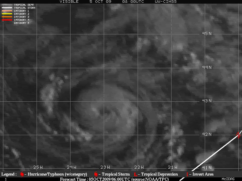
Like at the big CAT5 Isabel.. rimember?
Probably GRACE is a Hurricane in a very short part around the center.

After an email that I have sent the NHC yesterday you know what you/they had answered me with a lot of superficiality' and little interest?? "not have tropical caracteristic and have cold core.".
To this point I have clearly said that I probably talked to a simple secretary employed to the answers and not with an expert of tropical ciclogenesi, since the system had Evident tropical characteristics, and it was so' small that you/they would hardly have seen a warm core, and that a similar convectiv thunderstorms center exclusively be present in a warm core cyclone.
I have concluded writing that the 90L was not an INVEST but an evident TROPICAL STORM.
To this point I have also invited the boys of the Spanish forum to send email to the NHC..
Incredibly, after you/they had cancelled entirely the system, today you/they have not made him reappear, as TROPICAL DEPRESSION or SUBTROPICAL, but directly as TROPICAL STORM GRACE.
The nhc has shown more' evidently turned little wanted interest for systems of the Atlantic north/east, if that you/they had been on the side USA you/they would have been classified from immediately as tropical depression, tropical storm or hurricane.
Daniele Bianchino
Rome - Italy
Like at the big CAT5 Isabel.. rimember?
Probably GRACE is a Hurricane in a very short part around the center.

Last edited by DanieleItalyRm on Mon Oct 05, 2009 8:03 am, edited 3 times in total.
0 likes
-
leanne_uk
- Tropical Storm

- Posts: 214
- Age: 43
- Joined: Fri Sep 04, 2009 4:38 pm
- Location: Loughborough countryside, Leicestershire, UK
Re: ATL : Invest 90L
I have just finally been discharged from hopital to get home an log on to see not only do we have our Grace, is Uk bound 
I am so glad that something we have not given up on and watched for days has paid off
Lets see what happens, I cannot wait thats for sure
I am so glad that something we have not given up on and watched for days has paid off
Lets see what happens, I cannot wait thats for sure
breeze wrote::uarrow: Leanne, there's your answer to where it may go!
Amazing, indeed!
0 likes
-
HURAKAN

- Professional-Met

- Posts: 46084
- Age: 39
- Joined: Thu May 20, 2004 4:34 pm
- Location: Key West, FL
- Contact:
860
WHXX01 KWBC 051237
CHGHUR
TROPICAL CYCLONE GUIDANCE MESSAGE
NWS TPC/NATIONAL HURRICANE CENTER MIAMI FL
1237 UTC MON OCT 5 2009
DISCLAIMER...NUMERICAL MODELS ARE SUBJECT TO LARGE ERRORS.
PLEASE REFER TO NHC OFFICIAL FORECASTS FOR TROPICAL CYCLONE
AND SUBTROPICAL CYCLONE INFORMATION.
ATLANTIC OBJECTIVE AIDS FOR
TROPICAL CYCLONE GRACE (AL092009) 20091005 1200 UTC
...00 HRS... ...12 HRS... ...24 HRS. .. ...36 HRS...
091005 1200 091006 0000 091006 1200 091007 0000
LAT LON LAT LON LAT LON LAT LON
BAMS 44.3N 17.2W 47.0N 15.4W 48.5N 13.6W 49.2N 11.9W
BAMD 44.3N 17.2W 47.6N 15.7W 50.0N 13.0W 52.2N 7.3W
BAMM 44.3N 17.2W 47.3N 15.3W 49.2N 12.9W 50.7N 9.4W
LBAR 44.3N 17.2W 48.5N 12.4W 52.5N 4.1W 55.4N 9.4E
SHIP 55KTS 56KTS 58KTS 60KTS
DSHP 55KTS 56KTS 58KTS 60KTS
...48 HRS... ...72 HRS... ...96 HRS. .. ..120 HRS...
091007 1200 091008 1200 091009 1200 091010 1200
LAT LON LAT LON LAT LON LAT LON
BAMS 49.7N 10.8W 48.5N 6.4W 49.2N .4W 50.8N 9.1E
BAMD 54.3N 2.3E 55.8N 27.6E 57.5N 51.7E 61.3N 73.7E
BAMM 52.2N 4.9W 55.7N 8.1E 55.8N 26.1E 55.5N 42.4E
LBAR .0N .0W .0N .0W .0N .0W .0N .0W
SHIP 64KTS 58KTS 53KTS 40KTS
DSHP 51KTS 38KTS 33KTS 20KTS
...INITIAL CONDITIONS...
LATCUR = 44.3N LONCUR = 17.2W DIRCUR = 35DEG SPDCUR = 27KT
LATM12 = 40.2N LONM12 = 21.3W DIRM12 = 48DEG SPDM12 = 25KT
LATM24 = 38.3N LONM24 = 26.8W
WNDCUR = 55KT RMAXWD = 15NM WNDM12 = 55KT
CENPRS = 990MB OUTPRS = 996MB OUTRAD = 100NM SDEPTH = M
RD34NE = 30NM RD34SE = 60NM RD34SW = 60NM RD34NW = 0NM
$$
NNNN
0 likes
-
DanieleItalyRm
- Category 1
- Posts: 487
- Age: 40
- Joined: Mon Sep 22, 2008 7:52 am
- Location: Rome - Italy - Mediterranean sea

Re: ATL : TROPICAL STORM GRACE
I think that the Grace's Tropical Cyclone Report will be very interesting if it discusses the factors that helped this storm to develop in such a high latitude and over cool waters.
0 likes
-
DanieleItalyRm
- Category 1
- Posts: 487
- Age: 40
- Joined: Mon Sep 22, 2008 7:52 am
- Location: Rome - Italy - Mediterranean sea
Re: ATL : TROPICAL STORM GRACE
Macrocane wrote:I think that the Grace's Tropical Cyclone Report will be very interesting if it discusses the factors that helped this storm to develop in such a high latitude and over cool waters.
Very Like Hurricane Karl November 1980.. cold core origin and cool waters.
0 likes


Who is online
Users browsing this forum: No registered users and 51 guests