
ATL : TROPICAL STORM GRACE
Moderator: S2k Moderators
-
leanne_uk
- Tropical Storm

- Posts: 214
- Age: 43
- Joined: Fri Sep 04, 2009 4:38 pm
- Location: Loughborough countryside, Leicestershire, UK
Re:
HURAKAN wrote:
Watch out England!!!
Nothing at all out of the blue for the UK. Forecast in general is showing max gusting wind speeds in my area of the North West of England hitting no more than 29mph Gusts at around 4pm GMT. Rainfall as to be exected also but all in all a normal October day here for us
0 likes
-
Cryomaniac
- Category 5

- Posts: 1289
- Joined: Tue Aug 15, 2006 2:26 pm
- Location: Newark, Nottinghamshire, UK
- Contact:
Re: Re:
ozonepete wrote:leanne_uk wrote::uarrow: Pete as much as I would love a hurricane I really cant see grace holding herself well enough over the next 24-36 hours in the cooler waters to give the UK anything to worry about at all should she continue to track NE.
She is a stunner though and its great that this is one I have saw develop fron the very beginning, make me just a little happy
Oh yeah, I know it can never hold up as tropical over those waters, but you might get a puff of wind and some rain out of it, although more likely whatever's left will move more over Ireland.
I'm tempted to say "never say never", but if this is still tropical when it hits Ireland I'll be impressed lol.
0 likes
-
leanne_uk
- Tropical Storm
- Posts: 214
- Age: 43
- Joined: Fri Sep 04, 2009 4:38 pm
- Location: Loughborough countryside, Leicestershire, UK
Re: Re:
Cryomaniac wrote:ozonepete wrote:leanne_uk wrote::uarrow: Pete as much as I would love a hurricane I really cant see grace holding herself well enough over the next 24-36 hours in the cooler waters to give the UK anything to worry about at all should she continue to track NE.
She is a stunner though and its great that this is one I have saw develop fron the very beginning, make me just a little happy
Oh yeah, I know it can never hold up as tropical over those waters, but you might get a puff of wind and some rain out of it, although more likely whatever's left will move more over Ireland.
I'm tempted to say "never say never", but if this is still tropical when it hits Ireland I'll be impressed lol.
If this is still tropical when it gets near Ireland and the UK there will be alot more than you impressed.
I think the guys over at the Met office would be a little stressed out that a system was over looked so much as they do not show any weather advisories at all for the next 24/36 hours lol
I am looking forward to a Duvet day tomorrow should the weather be a miserable as it looks for my area
0 likes


-
leaf blower

- Tropical Low

- Posts: 39
- Joined: Mon Jul 21, 2008 8:01 am
-
cycloneye

- Admin

- Posts: 149725
- Age: 69
- Joined: Thu Oct 10, 2002 10:54 am
- Location: San Juan, Puerto Rico
Re: ATL : TROPICAL STORM GRACE
18 UTC Best track:
AL, 09, 2009100518, , BEST, 0, 466N, 156W, 55, 990, TS
ftp://ftp.tpc.ncep.noaa.gov/atcf/tcweb/ ... 009.invest
AL, 09, 2009100518, , BEST, 0, 466N, 156W, 55, 990, TS
ftp://ftp.tpc.ncep.noaa.gov/atcf/tcweb/ ... 009.invest
0 likes
Visit the Caribbean-Central America Weather Thread where you can find at first post web cams,radars
and observations from Caribbean basin members Click Here
and observations from Caribbean basin members Click Here

-
ozonepete
- Professional-Met

- Posts: 4743
- Joined: Mon Sep 07, 2009 3:23 pm
- Location: From Ozone Park, NYC / Now in Brooklyn, NY
Re:
CrazyC83 wrote:Reality is starting to set in.
Does diurnal maximum make any significant difference at such high latitudes?
It won't in this case, no. The nocturnal convective max is caused by very warm ocean temps beneath the tropical low contrasted with very cold cloud tops over the storm at night. It's the large temperature difference between the two that encourages strong convection. In this case the ocean temps are just not warm enough anymore to provide a big difference in ocean to cloudtop temps during the night.
0 likes
-
P.K.

- Professional-Met
- Posts: 5149
- Joined: Thu Sep 23, 2004 5:57 pm
- Location: Watford, England
- Contact:
Re: ATL : TROPICAL STORM GRACE
I see some questioning on here as to if Grace is actually a TC or not. For what is is worth I think this is clearly a TC. I'm at 51N and this really isn't too far off that now!
0 likes
-
Steve Cosby

- S2K Supporter

- Posts: 525
- Joined: Sat Jun 14, 2003 6:49 pm
- Location: Northwest Arkansas
Re: Re:
HURAKAN wrote:CrazyC83 wrote:Personally, I think it has been a tropical storm since 0000Z on October 1.
Likely the most interesting post-season report will come from Grace
No - the most interesting post-season report will come from the unnamed storm that hit New Jersey.
0 likes
-
cycloneye
- Admin
- Posts: 149725
- Age: 69
- Joined: Thu Oct 10, 2002 10:54 am
- Location: San Juan, Puerto Rico
Re: ATL : TROPICAL STORM GRACE - Advisories
000
WTNT34 KNHC 052033
TCPAT4
BULLETIN
TROPICAL STORM GRACE ADVISORY NUMBER 4
NWS TPC/NATIONAL HURRICANE CENTER MIAMI FL AL092009
500 PM AST MON OCT 05 2009
...GRACE SPEEDING NORTH-NORTHEASTWARD WEST OF FRANCE...EXPECTED TO
BE ABSORBED BY FRONT BY EARLY TOMORROW...
AT 500 PM AST...2100 UTC...THE CENTER OF TROPICAL STORM GRACE WAS
LOCATED NEAR LATITUDE 47.7 NORTH...LONGITUDE 14.8 WEST OR ABOUT 400
MILES...645 KM...SOUTHWEST OF CORK IRELAND...AND ABOUT 480 MILES...
775 KM....WEST OF BREST FRANCE.
GRACE IS MOVING TOWARD THE NORTH-NORTHEAST NEAR 30 MPH...48 KM/HR. A
SLIGHT DECREASE IN FORWARD SPEED IS EXPECTED TONIGHT.
MAXIMUM SUSTAINED WINDS HAVE DECREASED TO NEAR 60 MPH...95
KM/HR...WITH HIGHER GUSTS. LITTLE CHANGE IN STRENGTH IS EXPECTED
BEFORE GRACE IS ABSORBED BY A FRONT BY TUESDAY MORNING.
TROPICAL STORM FORCE WINDS EXTEND OUTWARD UP TO 70 MILES...110 KM
FROM THE CENTER.
THE ESTIMATED MINIMUM CENTRAL PRESSURE IS 990 MB...29.23 INCHES.
...SUMMARY OF 500 PM AST INFORMATION...
LOCATION...47.7N 14.8W
MAXIMUM SUSTAINED WINDS...60 MPH
PRESENT MOVEMENT...NORTH-NORTHEAST OR 25 DEGREES AT 30 MPH
MINIMUM CENTRAL PRESSURE...990 MB
THE NEXT ADVISORY WILL BE ISSUED BY THE NATIONAL HURRICANE CENTER AT
1100 PM AST.
$$
FORECASTER BRENNAN
TROPICAL STORM GRACE DISCUSSION NUMBER 4
NWS TPC/NATIONAL HURRICANE CENTER MIAMI FL AL092009
500 PM AST MON OCT 05 2009
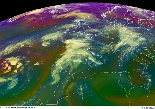
GRACE CONTINUES TO HAVE THE SATELLITE APPEARANCE OF A TROPICAL
CYCLONE AND A MODERATE TO DEEP WARM CORE AS INDICATED BY RECENT
AMSU PASSES. HOWEVER...CLOUD TOP TEMPERATURES HAVE CONTINUED TO
WARM OVER THE PAST FEW HOURS AS THE CYCLONE IS NOW OVER SSTS OF
17-18C. THE INTENSITY IS DECREASED TO 50 KT BASED A SUBTROPICAL
CLASSIFICATION OF 3.5 FROM TAFB AND A DVORAK CI-NUMBER OF 3.0 FROM
SAB. A QUIKSCAT PASS SHOULD PROVIDE SOME INFORMATION ON THE
INTENSITY AND STRUCTURE OF GRACE SOON. THE CENTRAL PRESSURE IS HELD
AT 990 MB BASED ON AN 1800 UTC OBSERVATION OF 992 MB AND A WIND OF
20 KT FROM SHIP A8I02 ABOUT 30 NM NORTH OF THE CENTER OF GRACE.
THE INITIAL MOTION ESTIMATE IS 025/26 KT...AS GRACE IS BEING STEERED
BY DEEP-LAYER SOUTHWESTERLY FLOW AHEAD OF A MID- TO UPPER-LEVEL
TROUGH ALONG 27W. BY TUESDAY MORNING...ALL OF THE GLOBAL MODELS
SHOW GRACE BEING ABSORBED BY A FRONT ASSOCIATED WITH A DEEPENING
EXTRATROPICAL CYCLONE TO THE NORTHWEST OF THE BRITISH ISLES.
IT IS WORTH NOTING THAT OTHER ATLANTIC TROPICAL STORMS HAVE FORMED
FARTHER NORTH THAN GRACE DID. IN 2008 TROPICAL STORM LAURA WAS
FIRST CLASSIFIED AS A TROPICAL STORM AT 40.6N....SLIGHTLY FARTHER
NORTH THAN THE LATITUDE OF 40.2N WHERE GRACE WAS FIRST CLASSIFIED
AS A TROPICAL STORM AT 0000 UTC TODAY. ALSO...IT IS LIKELY THAT
POST-STORM ANALYSIS WILL SHOW GRACE BECOMING A TROPICAL STORM
EARLIER...AND FARTHER SOUTH...THAN INDICATED OPERATIONALLY.
FORECAST POSITIONS AND MAX WINDS
INITIAL 05/2100Z 47.7N 14.8W 50 KT
12HR VT 06/0600Z 50.6N 12.0W 50 KT
24HR VT 06/1800Z...DISSIPATED
$$
FORECASTER BRENNAN
0 likes
Visit the Caribbean-Central America Weather Thread where you can find at first post web cams,radars
and observations from Caribbean basin members Click Here
and observations from Caribbean basin members Click Here
-
cycloneye
- Admin
- Posts: 149725
- Age: 69
- Joined: Thu Oct 10, 2002 10:54 am
- Location: San Juan, Puerto Rico
Re: ATL : TROPICAL STORM GRACE
From 5 PM discussion.
IT IS LIKELY THAT
POST-STORM ANALYSIS WILL SHOW GRACE BECOMING A TROPICAL STORM
EARLIER...AND FARTHER SOUTH...THAN INDICATED OPERATIONALLY.
http://www.nhc.noaa.gov/text/refresh/MI ... 2034.shtml
Yes!!!
IT IS LIKELY THAT
POST-STORM ANALYSIS WILL SHOW GRACE BECOMING A TROPICAL STORM
EARLIER...AND FARTHER SOUTH...THAN INDICATED OPERATIONALLY.
http://www.nhc.noaa.gov/text/refresh/MI ... 2034.shtml
Yes!!!
0 likes
Visit the Caribbean-Central America Weather Thread where you can find at first post web cams,radars
and observations from Caribbean basin members Click Here
and observations from Caribbean basin members Click Here
-
P.K.
- Professional-Met
- Posts: 5149
- Joined: Thu Sep 23, 2004 5:57 pm
- Location: Watford, England
- Contact:
Re: ATL : TROPICAL STORM GRACE
First time I've seen Brest in one of these as well!
AT 500 PM AST...2100 UTC...THE CENTER OF TROPICAL STORM GRACE WAS
LOCATED NEAR LATITUDE 47.7 NORTH...LONGITUDE 14.8 WEST OR ABOUT 400
MILES...645 KM...SOUTHWEST OF CORK IRELAND...AND ABOUT 480 MILES...
775 KM....WEST OF BREST FRANCE.
AT 500 PM AST...2100 UTC...THE CENTER OF TROPICAL STORM GRACE WAS
LOCATED NEAR LATITUDE 47.7 NORTH...LONGITUDE 14.8 WEST OR ABOUT 400
MILES...645 KM...SOUTHWEST OF CORK IRELAND...AND ABOUT 480 MILES...
775 KM....WEST OF BREST FRANCE.
0 likes
-
AdamFirst

- S2K Supporter
- Posts: 2490
- Age: 36
- Joined: Thu Aug 14, 2008 10:54 am
- Location: Port Saint Lucie, FL
This is odd. A tropical system developing and maintaining that far north. Any chance of Grace hitting Ireland while still tropical?
0 likes
Dolphins Marlins Canes Golden Panthers HEAT
Andrew 1992 - Irene 1999 - Frances 2004 - Jeanne 2004 - Wilma 2005 - Fay 2008 - Isaac 2012 - Matthew 2016 - Irma 2017 - Dorian 2019 - Ian 2022 - Nicole 2022 - Milton 2024
Andrew 1992 - Irene 1999 - Frances 2004 - Jeanne 2004 - Wilma 2005 - Fay 2008 - Isaac 2012 - Matthew 2016 - Irma 2017 - Dorian 2019 - Ian 2022 - Nicole 2022 - Milton 2024
-
CrazyC83
- Professional-Met
- Posts: 34316
- Joined: Tue Mar 07, 2006 11:57 pm
- Location: Deep South, for the first time!
Re:
AdamFirst wrote:This is odd. A tropical system developing and maintaining that far north. Any chance of Grace hitting Ireland while still tropical?
It isn't out of the question, but the odds are against it. It is about 350 miles from the southwestern tip of Ireland (which is at about 51.5N 9.6W), so landfall would be about 12 hours from now at the current speed.
0 likes
-
ozonepete
- Professional-Met
- Posts: 4743
- Joined: Mon Sep 07, 2009 3:23 pm
- Location: From Ozone Park, NYC / Now in Brooklyn, NY
Re: Re:
CrazyC83 wrote:AdamFirst wrote:This is odd. A tropical system developing and maintaining that far north. Any chance of Grace hitting Ireland while still tropical?
It isn't out of the question, but the odds are against it. It is about 350 miles from the southwestern tip of Ireland (which is at about 51.5N 9.6W), so landfall would be about 12 hours from now at the current speed.
Yeah, I agree. Not very likely, but it could come inland in southern Ireland land with some of its tropical characteristics left, like maybe a rain-free eye or still a small core of strongest winds around the center. It happens on the northeast coast of the U.S. and Canada sometimes when the system is moving very fast, as Grace is.
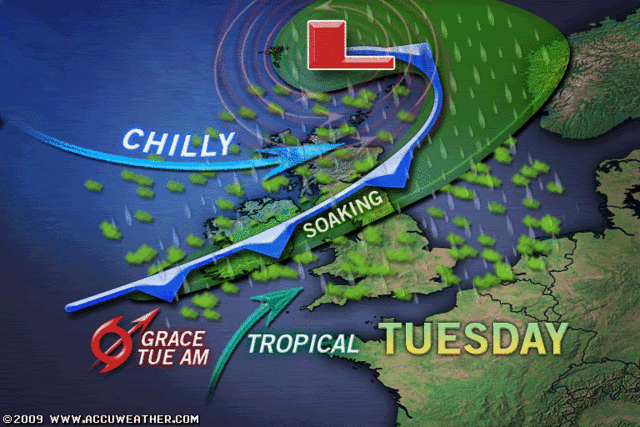
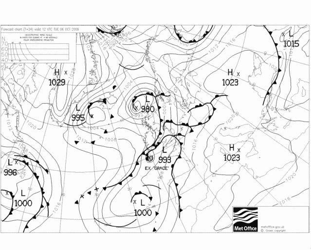
Here's the UKMET office forecast for tomorrow at 12Z, right around when Grace comes in. Notice it's "EX GRACE", meaning extratropical.
0 likes
-
Derek Ortt
Who is online
Users browsing this forum: No registered users and 82 guests