AdamFirst wrote:http://www.metoffice.gov.uk/weather/uk/radar/
British Isles Radar Loop...not a real high quality radar but still
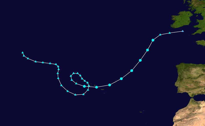
Thanks! MAybe not great, but it tells the story.
Moderator: S2k Moderators

AdamFirst wrote:http://www.metoffice.gov.uk/weather/uk/radar/
British Isles Radar Loop...not a real high quality radar but still

breeze wrote:Cryomaniac wrote: That still looks almost tropical, although looks are often deceiving. It's pretty warm and windy here in the East of England, looks like we'll get the rain tomorrow.
Met office says heavy rain for East Midlands from 19:05 - 22:00 Oct 6th - keep your umbrella handy, Cryomaniac!
http://www.metoffice.gov.uk/weather/uk/ ... nings.html
ozonepete wrote:Just amazing. Still has some tropical characteristics like banding into a center.


DanieleItalyRm wrote:Everybody tropical cyclones that had become in Extratropical had evident Extratropical characteristics.. but GRACE have still some evident tropical caracteristic:

DanieleItalyRm wrote:Everybody tropical cyclones that had become in Extratropical had evident Extratropical characteristics.. but GRACE have still some evident tropical characteristics:
DanieleItalyRm wrote:..Tropical Storm or at least a Subtropical Storm. The satellite presentation appears as if it is a Hurricane.
Kindly, we would like a small explanation of why 90L is just that, an invest and nothing more.
Warm Regards,
Jonathan Belles.
Weather Enthusiast and Future Meteorologist
Storm2k.org member
Respuesta:
Dear Jonathan Belles,
I tried to call the NHC without success. That's why I jumped on my bike to see what was going on.
When I arrived I met the staff in the pool room. They just ordered some pizza and some Johny Walker and were having a great time.
I told them about your e-mail and after drinking 3 cans of coffee they decided to give it a go. I pointed out the position and one of them answered: "There nothing there! " I advised him to take his glasses on as he can't see very well without.
Now everything is under control. Thank you!
Grece es parecida a otros tropical ciclones del Norte este atlántico ignorados:
unnamed 92L Jun.2009 50 knots (tropical storm)
unnamed Sept. 2008 50 knots (tropical storm)
unamed Jun. 2009 30 knots (tropical depression)
unnamed Nov.2004 45 knots (tropical storm)
unnamed Oct.1997 (tropical storm or hurricane)


Derek Ortt wrote:ozonepete wrote:Derek Ortt wrote:eyes are present routinely in tropical storms with winds of about 50KT. Usually, they are not visible due to cirrus overcast, but are on radar and microwave imagery
We don't have cirrus overcast here; thus, we could see the eye earlier
The key phrase you used is cirrus overcast, and the key word left out is "developing." We've all seen hurricanes weakening into a TS that keep their CLEAR eye. But has there ever been a tropical storm DEVELOPING into a hurricane that showed a CLEAR eye BEFORE it made hurricane? I've never seen one in all of the satellite image history we have and all of the storms I've followed. So if Grace was on the upswing, producing a CLEAR eye BEFORE the DEVELOPING TS became a hurricane would be a first. I defer to you on this - you are an expert and I admire your work. But if you have an example I would love to see it.
And of course, a DEVELOPING TS often has an "EYE" detectible by SSMI because the "eye" circulation it shows is a developing area of subsidence that forms from the lower levels up as the radius of maximum winds consolidates. In that DEVELOPMENT situation we'd always expect a cirrus canopy until the winds have reached a critical number (about 89mph) where the cirrus can clear out.
it is quite common to have an eye with this type of tropical cyclone prior to hurricane status
see Vince and Michael
Users browsing this forum: No registered users and 59 guests