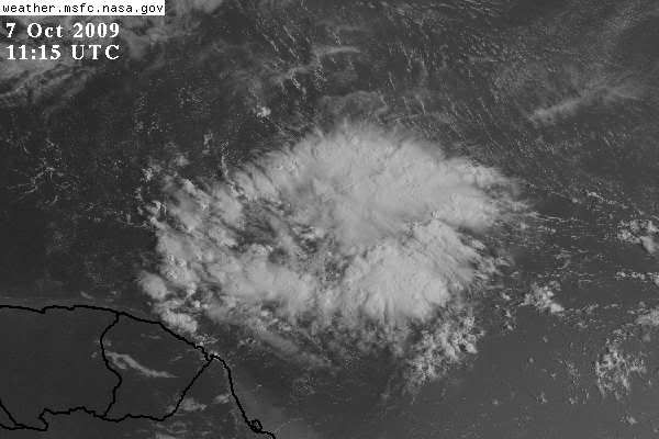
An Atlantic Ocean tropical wave is along 40w/41w to the south
of 10n moving west 15 kt. Widely scattered to scattered strong
showers and thunderstorms from 6n to 10n between 41w and 48w.
Look a little suspicious
Wave behind Henri
Moderator: S2k Moderators
Forum rules

The posts in this forum are NOT official forecasts and should not be used as such. They are just the opinion of the poster and may or may not be backed by sound meteorological data. They are NOT endorsed by any professional institution or STORM2K. For official information, please refer to products from the National Hurricane Center and National Weather Service.


-
jconsor
- Professional-Met

- Posts: 580
- Joined: Mon Jun 30, 2008 9:31 pm
- Location: Jerusalem, Israel
- Contact:
Re: Wave behind Henri
Yes, the tropical wave behind Henri at about 45W has flared up nicely tonight. Cyclonic turning is evident on sat loops and an ASCAT pass from 00Z (http://manati.orbit.nesdis.noaa.gov/ascat/). It also located right underneath an upper-level high.
Honestly, I think this wave has a better chance for long-term survival than Henri. It is quite far to the south now and is expected to continue WNW over the next few days, allowing it to avoid most of the TUTT-related shear, unlike Henri. However, it will still face some shear and dry air in the E. Caribbean due to strong upper level northeasterly winds circulating around an upper high centered near the Bahamas.
Two experimental WRF runs and an experimental MM5 run from Florida State University indicate gradual development as the system approaches the Windward and Leeward Islands.
http://weather.myfox...rf/wrf_slp.html
http://tempest.meas...._radar_d01.html
http://moe.met.fsu.edu/mm5/
0 likes
-
leanne_uk
- Tropical Storm

- Posts: 214
- Age: 43
- Joined: Fri Sep 04, 2009 4:38 pm
- Location: Loughborough countryside, Leicestershire, UK
Re: Wave behind Henri


Latest Sat images. Liking the look of this system and will be interesting to see how it handles the conditions out there
0 likes
-
cycloneye

- Admin

- Posts: 149517
- Age: 69
- Joined: Thu Oct 10, 2002 10:54 am
- Location: San Juan, Puerto Rico
Re: Wave behind Henri
TWOAT
TROPICAL WEATHER OUTLOOK
NWS TPC/NATIONAL HURRICANE CENTER MIAMI FL
800 AM EDT WED OCT 7 2009
FOR THE NORTH ATLANTIC...CARIBBEAN SEA AND THE GULF OF MEXICO...
THE NATIONAL HURRICANE CENTER IS ISSUING ADVISORIES ON TROPICAL
STORM HENRI...LOCATED ABOUT 460 MILES EAST OF THE NORTHERN
LEEWARD ISLANDS.
[b]SHOWERS AND THUNDERSTORMS HAVE INCREASED IN ASSOCIATION WITH A
TROPICAL WAVE LOCATED ABOUT 925 MILES EAST-SOUTHEAST OF THE
WINDWARD ISLANDS. DEVELOPMENT...IF ANY...OF THIS SYSTEM SHOULD BE
SLOW TO OCCUR AS IT MOVES TO THE WEST-NORTHWEST AT ABOUT 15 MPH.
THERE IS A LOW CHANCE...LESS THAN 30 PERCENT...OF THIS SYSTEM
BECOMING A TROPICAL CYCLONE DURING THE NEXT 48 HOURS.
ELSEWHERE...TROPICAL CYCLONE FORMATION IS NOT EXPECTED DURING THE
NEXT 48 HOURS.
PUBLIC ADVISORIES ON HENRI ARE ISSUED UNDER WMO HEADER WTNT35 KNHC
AND UNDER AWIPS HEADER MIATCPAT5. FORECAST/ADVISORIES ARE ISSUED
UNDER WMO HEADER WTNT25 KNHC AND UNDER AWIPS HEADER MIATCMAT5.
$$
FORECASTER BLAKE/PASCH
[/b]
0 likes
Visit the Caribbean-Central America Weather Thread where you can find at first post web cams,radars
and observations from Caribbean basin members Click Here
and observations from Caribbean basin members Click Here
-
Gustywind

- Category 5

- Posts: 12334
- Joined: Mon Sep 03, 2007 7:29 am
- Location: Baie-Mahault, GUADELOUPE
000
AXNT20 KNHC 071043
TWDAT
TROPICAL WEATHER DISCUSSION
NWS TPC/NATIONAL HURRICANE CENTER MIAMI FL
805 AM EDT WED OCT 07 2009
TROPICAL WEATHER DISCUSSION FOR NORTH AMERICA...CENTRAL
AMERICA...GULF OF MEXICO...CARIBBEAN SEA...NORTHERN SECTIONS
OF SOUTH AMERICA...AND ATLANTIC OCEAN TO THE AFRICAN COAST
FROM THE EQUATOR TO 32N. THE FOLLOWING INFORMATION IS BASED
ON SATELLITE IMAGERY...METEOROLOGICAL ANALYSIS...WEATHER
OBSERVATIONS...AND RADAR.
BASED ON 0600 UTC SURFACE ANALYSIS AND SATELLITE IMAGERY
THROUGH 1000 UTC.
...TROPICAL WAVES...
TROPICAL WAVE IS ALONG 45W S OF 10N MOVING W NEAR 15 KT.
SATELLITE IMAGERY INDICATES LOW-LEVEL CYCLONIC FLOW AROUND THE
WAVE AXIS. THE WAVE ALSO COINCIDES WITH A LOW AMPLITUDE DEEP
LAYER MOISTURE MAXIMUM OBSERVED IN TOTAL PRECIPITABLE WATER
IMAGERY. SCATTERED STRONG CONVECTION IS FROM 6N-12N BETWEEN
43W-48W. SCATTERED MODERATE/ISOLATED STRONG CONVECTION IS FROM
6N-11N BETWEEN 48W-52W.
$$
WALTON
0 likes

Re: Wave behind Henri
Looks decent, low shear, and a couple of models develop it. I´ve seen far more hopeless causes. Lesser Antilles should keep a weather-eye on this one.
0 likes
Re: Wave behind Henri
It's sort of expanding out and thinning.
Is there an MJO positive phase happening? The area seems to be turning on in tropical favorability.
I have a pet theory that the northern jet starts to descend and "pinch-off" the remaining tropical juice forcing it down into concentration in the formation latitudes for one last tropical burst in October.
0 likes


-
HURAKAN

- Professional-Met
- Posts: 46084
- Age: 39
- Joined: Thu May 20, 2004 4:34 pm
- Location: Key West, FL
- Contact:
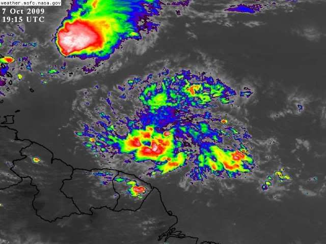
Loop: http://www.ssd.noaa.gov/goes/east/carb/flash-rgb.html
Convection needs to increase but you can see already a twist in the clouds as it moves north of west. Something to watch as it approaches the LA.
Convection needs to increase but you can see already a twist in the clouds as it moves north of west. Something to watch as it approaches the LA.
0 likes
-
cycloneye
- Admin
- Posts: 149517
- Age: 69
- Joined: Thu Oct 10, 2002 10:54 am
- Location: San Juan, Puerto Rico
Re: Wave behind Henri
TWOAT
TROPICAL WEATHER OUTLOOK
NWS TPC/NATIONAL HURRICANE CENTER MIAMI FL
200 PM EDT WED OCT 7 2009
FOR THE NORTH ATLANTIC...CARIBBEAN SEA AND THE GULF OF MEXICO...
THE NATIONAL HURRICANE CENTER IS ISSUING ADVISORIES ON WEAKENING
TROPICAL STORM HENRI...LOCATED ABOUT 375 MILES EAST OF THE NORTHERN
LEEWARD ISLANDS.
DISORGANIZED SHOWERS AND THUNDERSTORMS CONTINUE IN ASSOCIATION WITH
A TROPICAL WAVE LOCATED ABOUT 825 MILES EAST-SOUTHEAST OF THE
WINDWARD ISLANDS. DEVELOPMENT...IF ANY...OF THIS SYSTEM SHOULD BE
SLOW TO OCCUR AS IT MOVES TO THE WEST-NORTHWEST AT ABOUT 15 TO 20
MPH. THERE IS A LOW CHANCE...LESS THAN 30 PERCENT...OF THIS SYSTEM
BECOMING A TROPICAL CYCLONE DURING THE NEXT 48 HOURS.
ELSEWHERE...TROPICAL CYCLONE FORMATION IS NOT EXPECTED DURING THE
NEXT 48 HOURS.
$$
FORECASTER BLAKE/PASCH
0 likes
Visit the Caribbean-Central America Weather Thread where you can find at first post web cams,radars
and observations from Caribbean basin members Click Here
and observations from Caribbean basin members Click Here
-
Gustywind
- Category 5
- Posts: 12334
- Joined: Mon Sep 03, 2007 7:29 am
- Location: Baie-Mahault, GUADELOUPE
000
AXNT20 KNHC 071752
TWDAT
TROPICAL WEATHER DISCUSSION
NWS TPC/NATIONAL HURRICANE CENTER MIAMI FL
205 PM EDT WED OCT 07 2009
TROPICAL WEATHER DISCUSSION FOR NORTH AMERICA...CENTRAL
AMERICA...GULF OF MEXICO...CARIBBEAN SEA...NORTHERN SECTIONS
OF SOUTH AMERICA...AND ATLANTIC OCEAN TO THE AFRICAN COAST
FROM THE EQUATOR TO 32N. THE FOLLOWING INFORMATION IS BASED
ON SATELLITE IMAGERY...METEOROLOGICAL ANALYSIS...WEATHER
OBSERVATIONS...AND RADAR.
BASED ON 1200 UTC SURFACE ANALYSIS AND SATELLITE IMAGERY THROUGH
1715 UTC.
...TROPICAL WAVES...
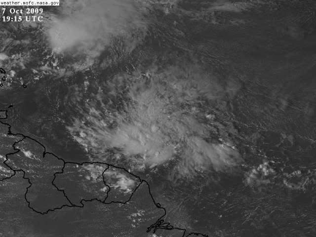
TROPICAL WAVE IS ALONG 48W S OF 11N MOVING W NEAR 20 KT. A 0900
UTC QUIKSCAT PASS INDICATED LOW-LEVEL CYCLONIC FLOW AROUND THE
WAVE AXIS. THE WAVE ALSO COINCIDES WITH A DEEP LAYER MOISTURE
MAXIMUM OBSERVED IN TOTAL PRECIPITABLE WATER IMAGERY. WIDELY
SCATTERED MODERATE CONVECTION IS FROM 6N-13N BETWEEN 44W-53W.
$$
LEWITSKY/HUFFMAN
AXNT20 KNHC 071752
TWDAT
TROPICAL WEATHER DISCUSSION
NWS TPC/NATIONAL HURRICANE CENTER MIAMI FL
205 PM EDT WED OCT 07 2009
TROPICAL WEATHER DISCUSSION FOR NORTH AMERICA...CENTRAL
AMERICA...GULF OF MEXICO...CARIBBEAN SEA...NORTHERN SECTIONS
OF SOUTH AMERICA...AND ATLANTIC OCEAN TO THE AFRICAN COAST
FROM THE EQUATOR TO 32N. THE FOLLOWING INFORMATION IS BASED
ON SATELLITE IMAGERY...METEOROLOGICAL ANALYSIS...WEATHER
OBSERVATIONS...AND RADAR.
BASED ON 1200 UTC SURFACE ANALYSIS AND SATELLITE IMAGERY THROUGH
1715 UTC.
...TROPICAL WAVES...
TROPICAL WAVE IS ALONG 48W S OF 11N MOVING W NEAR 20 KT. A 0900
UTC QUIKSCAT PASS INDICATED LOW-LEVEL CYCLONIC FLOW AROUND THE
WAVE AXIS. THE WAVE ALSO COINCIDES WITH A DEEP LAYER MOISTURE
MAXIMUM OBSERVED IN TOTAL PRECIPITABLE WATER IMAGERY. WIDELY
SCATTERED MODERATE CONVECTION IS FROM 6N-13N BETWEEN 44W-53W.
$$
LEWITSKY/HUFFMAN
0 likes

-
Tropicswatcher

- Tropical Depression

- Posts: 77
- Joined: Wed Jun 01, 2005 12:53 pm
- Location: San Juan, Puerto Rico
Re: Wave behind Henri
It's getting better organize. Already got the "cyclonic look'. Good antycyclone on top of it!
0 likes
-
cycloneye
- Admin
- Posts: 149517
- Age: 69
- Joined: Thu Oct 10, 2002 10:54 am
- Location: San Juan, Puerto Rico
Re: Wave behind Henri
Below is a discussion from Dr Jeff Master about the wave.
The tropical wave south of Henri, just off the coast of South America, has become more organized this afternoon. The thunderstorm activity has grown more concentrated near 8N 50W, with a hint of some low-level spiral banding starting to form. This wave is under about 10 knots of wind shear, but is too close to the Equator to be able to take advantage of the Earth's spin to help it spin up into a tropical depression very quickly. Also, the wave will suffer from interaction with the coast of South America on Thursday. NHC is giving this disturbance a low (less than 30% chance) or developing into a tropical depression by Friday.
0 likes
Visit the Caribbean-Central America Weather Thread where you can find at first post web cams,radars
and observations from Caribbean basin members Click Here
and observations from Caribbean basin members Click Here
-
Emmett_Brown

- Category 5
- Posts: 1433
- Joined: Wed Aug 24, 2005 9:10 pm
- Location: Sarasota FL
Re: Wave behind Henri
Starting to look invest-ish. Shear isn't much of a problem for this one. Land interaction with SA could slow development if it keeps on its current heading.
0 likes
Who is online
Users browsing this forum: No registered users and 103 guests