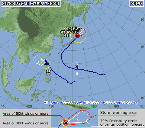
WPAC : TROPICAL STORM MELOR (20W)
Moderator: S2k Moderators
-
ozonepete
- Professional-Met

- Posts: 4743
- Joined: Mon Sep 07, 2009 3:23 pm
- Location: From Ozone Park, NYC / Now in Brooklyn, NY
Re: WPAC : SEVERE TROPICAL STORM MELOR (20W)
I saw reports that the highest wind recorded was 123 mph, but I don't know where. I assume at the coast south of Tokyo.
0 likes
- HURAKAN
- Professional-Met

- Posts: 46084
- Age: 39
- Joined: Thu May 20, 2004 4:34 pm
- Location: Key West, FL
- Contact:

WTPN34 PGTW 081500
MSGID/GENADMIN/NAVMARFCSTCEN PEARL HARBOR HI/JTWC//
SUBJ/TROPICAL CYCLONE WARNING//
RMKS/
1. EXTRATROPICAL STORM 20W (MELOR) WARNING NR 038
03 ACTIVE TROPICAL CYCLONES IN NORTHWESTPAC
MAX SUSTAINED WINDS BASED ON ONE-MINUTE AVERAGE
WIND RADII VALID OVER OPEN WATER ONLY
---
WARNING POSITION:
081200Z --- NEAR 40.2N 143.6E
MOVEMENT PAST SIX HOURS - 040 DEGREES AT 30 KTS
POSITION ACCURATE TO WITHIN 060 NM
POSITION BASED ON CENTER LOCATED BY SATELLITE
PRESENT WIND DISTRIBUTION:
MAX SUSTAINED WINDS - 045 KT, GUSTS 055 KT
WIND RADII VALID OVER OPEN WATER ONLY
EXTRATROPICAL
REPEAT POSIT: 40.2N 143.6E
---
FORECASTS:
12 HRS, VALID AT:
090000Z --- 43.1N 148.3E
MAX SUSTAINED WINDS - 040 KT, GUSTS 050 KT
WIND RADII VALID OVER OPEN WATER ONLY
EXTRATROPICAL
VECTOR TO 24 HR POSIT: 060 DEG/ 23 KTS
---
24 HRS, VALID AT:
091200Z --- 45.4N 154.0E
MAX SUSTAINED WINDS - 040 KT, GUSTS 050 KT
WIND RADII VALID OVER OPEN WATER ONLY
EXTRATROPICAL
---
REMARKS:
081500Z POSITION NEAR 40.9N 144.8E.
EXTRATROPICAL STORM 20W (MELOR), LOCATED APPROXIMATELY 115 NM
EAST OF MISAWA, JAPAN, HAS TRACKED NORTHEASTWARD AT 30 KNOTS OVER
THE PAST SIX HOURS. THE SYSTEM IS NO LONGER TROPICAL AND IS RAPIDLY
ACCELERATING DEEPER INTO THE MID-LATITUDES. THIS IS THE FINAL
WARNING ON THIS SYSTEM BY THE JOINT TYPHOON WARNING CENTER
(NAVMARFCSTCEN). THE SYSTEM WILL BE CLOSELY MONITORED FOR SIGNS
OF REGENERATION. MAXIMUM SIGNIFICANT WAVE HEIGHT AT 081200Z IS 18
FEET. REFER TO TROPICAL DEPRESSION 19W (PARMA) WARNINGS (WTPN33 PGTW)
FOR SIX-HOURLY UPDATES. REFER TO TROPICAL CYCLONE 21W (TWENTYONE)
WARNINGS (WTPN31 PGTW) FOR SIX-HOURLY UPDATES.//
NNNN
0 likes
- HURAKAN
- Professional-Met

- Posts: 46084
- Age: 39
- Joined: Thu May 20, 2004 4:34 pm
- Location: Key West, FL
- Contact:
ZCZC 464
WTPQ22 RJTD 081200
RSMC TROPICAL CYCLONE ADVISORY
NAME STS 0918 MELOR (0918)
ANALYSIS
PSTN 081200UTC 40.0N 143.6E FAIR
MOVE NE 28KT
PRES 980HPA
MXWD 060KT
GUST 085KT
50KT 120NM SOUTHEAST 100NM NORTHWEST
30KT 400NM SOUTHEAST 350NM NORTHWEST
FORECAST
24HF 091200UTC 44.1N 151.2E 85NM 70% EXTRATROPICAL LOW =
NNNN
0 likes
-
ozonepete
- Professional-Met

- Posts: 4743
- Joined: Mon Sep 07, 2009 3:23 pm
- Location: From Ozone Park, NYC / Now in Brooklyn, NY
Re: WPAC : SEVERE TROPICAL STORM MELOR (20W)
An initial assessment of how JMA and JTWC compared on the forecast track. i used the track forecasts from 2009-10-06 00Z.
The JMA had consolidated around a forecast for the center to go over the Kii peninsula, then over the western portion of the island well west of Tokyo in a north-northeast direction, not turning due NE until near the northern extent of the island. The JTWC had the track coming inland on Honshu just to the east of the Kii peninsula, then passing over or just west of Tokyo, and finally moving northeastward out to sea not far north of Tokyo.
The resulting track was almost exactly in between the two forecasts up until landfall. The center made landfall just east of the Kii peninsula, closer to the JTWC. After it made landfall, the JTWC did better on keeping the NE bend, and the JMA's forecast for the center to go more NNE and cross the extreme eastern Sea of Japan did not pan out.
I would say both did quite well, since the difference in their forecast tracks was less than 100 miles for the most part anyway.

0 likes
- vbhoutex
- Storm2k Executive

- Posts: 29145
- Age: 74
- Joined: Wed Oct 09, 2002 11:31 pm
- Location: Cypress, TX
- Contact:
Re: WPAC : TROPICAL STORM MELOR (20W)
I am going to throw out a question based on an email I received from ASLkahuna, part of which I have pasted here.
Any thoughts on this?
TY Melor now ET and the ET remnant could affect the West Coast after the weekend. October 12th in the Anniversary of the Columbus Day storm of 1962 so we do have to watch these typhoon remnants closely.
Any thoughts on this?
0 likes
- StormingB81
- S2K Supporter

- Posts: 5676
- Age: 44
- Joined: Thu Aug 27, 2009 1:45 am
- Location: Rockledge, Florida
- vbhoutex
- Storm2k Executive

- Posts: 29145
- Age: 74
- Joined: Wed Oct 09, 2002 11:31 pm
- Location: Cypress, TX
- Contact:
Re:
StormingB81 wrote:Say this stays tropical storm force. Can it make it to the west coast? Has a storm ever done that before?
I don't believe it can do that. What we would be dealing with is the remnant low of Melor I presume. Someone with more knowledge than I have can probably do a better explanation than I can. And as far as I know there has never been a TS approach the West Coast from the NW.
0 likes
- HURAKAN
- Professional-Met

- Posts: 46084
- Age: 39
- Joined: Thu May 20, 2004 4:34 pm
- Location: Key West, FL
- Contact:
ZCZC 818
WTPQ22 RJTD 090000
RSMC TROPICAL CYCLONE ADVISORY
NAME STS 0918 MELOR (0918)
ANALYSIS
PSTN 090000UTC 42.3N 147.7E FAIR
MOVE ENE 23KT
PRES 980HPA
MXWD 055KT
GUST 080KT
50KT 100NM NORTHEAST 80NM SOUTHWEST
30KT 500NM NORTHEAST 425NM SOUTHWEST
FORECAST
24HF 100000UTC 45.7N 157.9E 85NM 70% EXTRATROPICAL LOW =
NNNN
0 likes
-
ozonepete
- Professional-Met

- Posts: 4743
- Joined: Mon Sep 07, 2009 3:23 pm
- Location: From Ozone Park, NYC / Now in Brooklyn, NY
Re: Re:
vbhoutex wrote:StormingB81 wrote:Say this stays tropical storm force. Can it make it to the west coast? Has a storm ever done that before?
I don't believe it can do that. What we would be dealing with is the remnant low of Melor I presume. Someone with more knowledge than I have can probably do a better explanation than I can. And as far as I know there has never been a TS approach the West Coast from the NW.
OK. My professors at Penn State have noticed a trend for the remnants of a strong Typhoon affecting northeast Asia to come across the Pacific and move up into the Bering Strait, and then over Hudson Bay, causing very cool or cold air to eventually sink down into the northeastern U.S. about 7-10 days later. There's never been a typhoon coming across the Pacific and walloping the Pacific northwest since it can't survive as tropical. The famous 1962 storm formed, in part, from the reamins of a tropical storm in the CENTRAL PACIFIC, not any typhoon from east Asia.
Last edited by ozonepete on Fri Oct 09, 2009 8:24 am, edited 1 time in total.
0 likes
- brunota2003
- S2K Supporter

- Posts: 9476
- Age: 35
- Joined: Sat Jul 30, 2005 9:56 pm
- Location: Stanton, KY...formerly Havelock, NC
- Contact:
Here is a thread to cover the west coast US effects of this once powerful Typhoon:
viewtopic.php?f=24&t=106819
The thread mainly focuses on the San Fran Bay area, because I have fam and friends there, but feel free to include other effects as well!
viewtopic.php?f=24&t=106819
The thread mainly focuses on the San Fran Bay area, because I have fam and friends there, but feel free to include other effects as well!
0 likes
- wxmann_91
- Category 5

- Posts: 8007
- Age: 34
- Joined: Fri Jul 15, 2005 2:49 pm
- Location: Southern California
- Contact:
Re:
StormingB81 wrote:Say this stays tropical storm force. Can it make it to the west coast? Has a storm ever done that before?
This question is a bit vague.
Can it make it to the west coast as a tropical entity with TS force winds? Clearly, the answer is no, the westerlies and the baroclinicity are simply too strong at this latitude for a storm to remain tropical for too long.
Can the remnants of it make it to the west coast as a "storm" with TS force winds? Of course, and there are many precedents for this (the 1962 Columbus Day storm being the most infamous example). Ioke's extratropical remnants in 2006 blasted portions of AK. There is plenty of baroclinic energy up in this latitude for extratropical remnants of typhoons to not only maintain "TS-force" intensity but actually deepen (in some occasional instances). FWIW the latest ECMWF shows a ~972 mb low just west of the southern Oregon coast in a few days, with much of the energy derived from Melor.
0 likes
-
ozonepete
- Professional-Met

- Posts: 4743
- Joined: Mon Sep 07, 2009 3:23 pm
- Location: From Ozone Park, NYC / Now in Brooklyn, NY
Re: WPAC : TROPICAL STORM MELOR (20W)
0 likes
-
HurricaneBill
- Category 5

- Posts: 3419
- Joined: Sun Apr 11, 2004 5:51 pm
- Location: East Longmeadow, MA, USA
Re: Re:
ozonepete wrote: The famous 1962 storm formed, in part, from the reamins of a tropical storm in the CENTRAL PACIFIC, not any typhoon from east Asia.
Actually, the 1962 storm formed from the remnants of Typhoon Freda.

Freda's in the foreground. The other storm is Super Typhoon Emma.
0 likes
-
ozonepete
- Professional-Met

- Posts: 4743
- Joined: Mon Sep 07, 2009 3:23 pm
- Location: From Ozone Park, NYC / Now in Brooklyn, NY
Re: Re:
HurricaneBill wrote:ozonepete wrote: The famous 1962 storm formed, in part, from the reamins of a tropical storm in the CENTRAL PACIFIC, not any typhoon from east Asia.
Actually, the 1962 storm formed from the remnants of Typhoon Freda.
Freda's in the foreground. The other storm is Super Typhoon Emma.
Yes it was Freda, which apparently peaked at 115 mph. Sorry, I said tropical storm. But it was a central Pacific tropical cyclone, not an east Asian one. A lot of people think it originated in Asia.
0 likes
Who is online
Users browsing this forum: No registered users and 45 guests

