WPAC: SEVERE TROPICAL STORM LUPIT (22W)

Moderator: S2k Moderators

Message
Author
User avatar
theavocado
Professional-Met
Professional-Met
Posts: 162
Age: 49
Joined: Sun Mar 22, 2009 8:54 pm
Location: NOLA

Re: Re:

#321 Postby theavocado » Sun Oct 18, 2009 5:20 pm

ozonepete wrote: BTW, this is from the NHC site: LBAR is the NHC's implementation of the GFDL VICBAR model.


Which in itself is a terribly confusing statement. GFDL is both a nested model used to track cyclones and it's the name of the lab that developed the model (Geophysical Fluid Dynamics Laboratory). The model of that name is nested within GFS (GFDN is the same model nested within NOGAPS).

In this case, I think they are talking about the lab, because the model doesn't actually have fields in which to initialize a barotropic model. Presumably, NHC is running the VICBAR process with thier own fields as an initialization, and in this case it would be GFS.

For the record, WBAR uses the Harry Weber process, and not Victor Ooyama's, so they are not as closely related as GFDN and GFDL.
0 likes   

ozonepete
Professional-Met
Professional-Met
Posts: 4743
Joined: Mon Sep 07, 2009 3:23 pm
Location: From Ozone Park, NYC / Now in Brooklyn, NY

Re: Re:

#322 Postby ozonepete » Sun Oct 18, 2009 5:32 pm

theavocado wrote:
ozonepete wrote: BTW, this is from the NHC site: LBAR is the NHC's implementation of the GFDL VICBAR model.


Which in itself is a terribly confusing statement. GFDL is both a nested model used to track cyclones and it's the name of the lab that developed the model (Geophysical Fluid Dynamics Laboratory). The model of that name is nested within GFS (GFDN is the same model nested within NOGAPS).

In this case, I think they are talking about the lab, because the model doesn't actually have fields in which to initialize a barotropic model. Presumably, NHC is running the VICBAR process with thier own fields as an initialization, and in this case it would be GFS.

For the record, WBAR uses the Harry Weber process, and not Victor Ooyama's, so they are not as closely related as GFDN and GFDL.


Thanks for that, avocado. I appreciate your expertise. Although I had introductory lessons on the models, I never went back and studied all of the intricacies and differences. I really need to get moving with that - probably during the long cold winter that's fast approaching. :)
0 likes   

oaba09
S2K Supporter
S2K Supporter
Posts: 1496
Age: 38
Joined: Thu Oct 01, 2009 10:02 am
Location: Valenzuela, Philippines
Contact:

Re: WPAC: TYPHOON LUPIT (22W)

#323 Postby oaba09 » Sun Oct 18, 2009 5:52 pm

Should we expect any western movement anytime soon or is the NE movement still possible?....Is the trough still deep enough to prevent any W movement?
0 likes   

ozonepete
Professional-Met
Professional-Met
Posts: 4743
Joined: Mon Sep 07, 2009 3:23 pm
Location: From Ozone Park, NYC / Now in Brooklyn, NY

Re: WPAC: TYPHOON LUPIT (22W)

#324 Postby ozonepete » Sun Oct 18, 2009 6:33 pm

oaba09 wrote:Should we expect any western movement anytime soon or is the NE movement still possible?....Is the trough still deep enough to prevent any W movement?


All of the models except one still forecast a westward turn. But it was supposed to have turned by now and it hasn't; it's still moving northeastward. The longer it keeps going poleward, the more likely it is that Lupit may miss the Philippines to the north. But, and I know you're tired of hearing this, it's still too early to tell for sure. The JTWC forecast now has moved the passage of Lupit north or near the Luzon north coast all the way to Thursday morning your time. A lot can happen between now and then. Luckily you're gaining valuable time for the water levels to go down more. :)
0 likes   

User avatar
cycloneye
Admin
Admin
Posts: 145299
Age: 68
Joined: Thu Oct 10, 2002 10:54 am
Location: San Juan, Puerto Rico

Re: WPAC: TYPHOON LUPIT (22W)

#325 Postby cycloneye » Sun Oct 18, 2009 6:42 pm

ozonepete,as long the poleward motion continues,Taiwan increasinly gets into the fray right?
0 likes   
Visit the Caribbean-Central America Weather Thread where you can find at first post web cams,radars
and observations from Caribbean basin members Click Here

oaba09
S2K Supporter
S2K Supporter
Posts: 1496
Age: 38
Joined: Thu Oct 01, 2009 10:02 am
Location: Valenzuela, Philippines
Contact:

Re: WPAC: TYPHOON LUPIT (22W)

#326 Postby oaba09 » Sun Oct 18, 2009 6:48 pm

ozonepete wrote:
oaba09 wrote:Should we expect any western movement anytime soon or is the NE movement still possible?....Is the trough still deep enough to prevent any W movement?


All of the models except one still forecast a westward turn. But it was supposed to have turned by now and it hasn't; it's still moving northeastward. The longer it keeps going poleward, the more likely it is that Lupit may miss the Philippines to the north. But, and I know you're tired of hearing this, it's still too early to tell for sure. The JTWC forecast now has moved the passage of Lupit north or near the Luzon north coast all the way to Thursday morning your time. A lot can happen between now and then. Luckily you're gaining valuable time for the water levels to go down more. :)


Thank you!

Unfortunately, JMA's latest forecast has the system passing south of where JTWC predicted...If this happens, I can't even think of the disaster that wil hapen...
0 likes   

User avatar
theavocado
Professional-Met
Professional-Met
Posts: 162
Age: 49
Joined: Sun Mar 22, 2009 8:54 pm
Location: NOLA

Re: WPAC: TYPHOON LUPIT (22W)

#327 Postby theavocado » Sun Oct 18, 2009 6:59 pm

cycloneye wrote:ozonepete,as long the poleward motion continues,Taiwan increasinly gets into the fray right?


Yes and no. There is a large subtropical ridge over southern China, and if it can keep it's strength it could actually steer Lupit to the west southwest and still put Luzon in danger. If you look, most of the agencies are calling for this track to actually move slightly southward in the later forecast times.
0 likes   

oaba09
S2K Supporter
S2K Supporter
Posts: 1496
Age: 38
Joined: Thu Oct 01, 2009 10:02 am
Location: Valenzuela, Philippines
Contact:

Re: WPAC: TYPHOON LUPIT (22W)

#328 Postby oaba09 » Sun Oct 18, 2009 7:06 pm

theavocado wrote:
cycloneye wrote:ozonepete,as long the poleward motion continues,Taiwan increasinly gets into the fray right?


Yes and no. There is a large subtropical ridge over southern China, and if it can keep it's strength it could actually steer Lupit to the west southwest and still put Luzon in danger. If you look, most of the agencies are calling for this track to actually move slightly southward in the later forecast times.


That's the reason why we still need to be prepared.....What's the worst case scenario for the Philippines here?
0 likes   

User avatar
HURAKAN
Professional-Met
Professional-Met
Posts: 46086
Age: 38
Joined: Thu May 20, 2004 4:34 pm
Location: Key West, FL
Contact:

#329 Postby HURAKAN » Sun Oct 18, 2009 7:08 pm

Image

Image

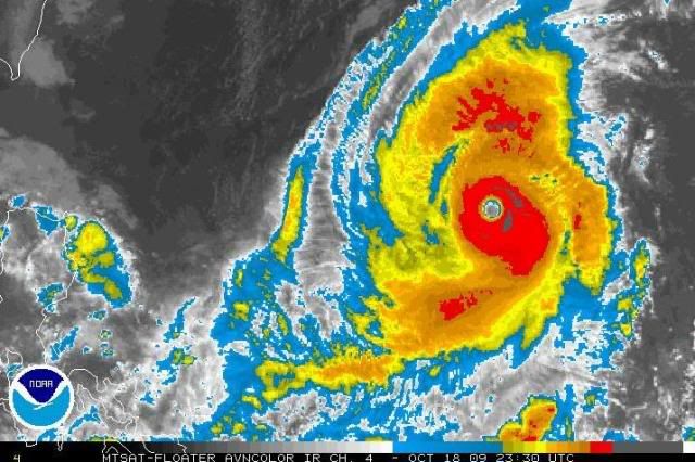
Very impressive
0 likes   

ozonepete
Professional-Met
Professional-Met
Posts: 4743
Joined: Mon Sep 07, 2009 3:23 pm
Location: From Ozone Park, NYC / Now in Brooklyn, NY

Re:

#330 Postby ozonepete » Sun Oct 18, 2009 7:30 pm

HURAKAN wrote:Very impressive


Totally agree. It doesn't have perfect symmetry, but the eye is very clear and beautifully shaped. I'm really impressed as well.

BTW, the last few images sure look like it's turning northwestward, although once again we have to wait due to track wobbles in a storm this intense. But since the orientation of the storm's convective core has shifted SE to NW as well, I'm getting a little more convinced.

Image
Last edited by ozonepete on Sun Oct 18, 2009 7:33 pm, edited 1 time in total.
0 likes   

User avatar
theavocado
Professional-Met
Professional-Met
Posts: 162
Age: 49
Joined: Sun Mar 22, 2009 8:54 pm
Location: NOLA

Re: WPAC: TYPHOON LUPIT (22W)

#331 Postby theavocado » Sun Oct 18, 2009 7:31 pm

oaba09 wrote:That's the reason why we still need to be prepared.....What's the worst case scenario for the Philippines here?


I can think of two really bad things that can happen:

1. The system maintains >100kts and makes a direct hit on Luzon and the winds and rain on the eastern side really do a lot of damage.

2. The system passes through the Strait of Luzon and strafes the northern coast with high winds, but since the flow won't be as effected, there will be significant upsloap winds on the WESTERN side of the island as the westerlies on the southern half of the system wrap around into the South China Sea. Since there will be no obstruction to the flow it could dump significant amounts of upslope precipitation on the northwest side of Luzon.

The posts in this forum are NOT official forecast and should not be used as such. They are just the opinion of the poster and may or may not be backed by sound meteorological data. They are NOT endorsed by any professional institution or storm2k.org. For official information, please refer to the local RSMC and PAGASA products.
0 likes   

User avatar
StormingB81
S2K Supporter
S2K Supporter
Posts: 5676
Age: 43
Joined: Thu Aug 27, 2009 1:45 am
Location: Rockledge, Florida

#332 Postby StormingB81 » Sun Oct 18, 2009 7:34 pm

your getting convinced of what?
0 likes   

oaba09
S2K Supporter
S2K Supporter
Posts: 1496
Age: 38
Joined: Thu Oct 01, 2009 10:02 am
Location: Valenzuela, Philippines
Contact:

Re: WPAC: TYPHOON LUPIT (22W)

#333 Postby oaba09 » Sun Oct 18, 2009 7:35 pm

theavocado wrote:
oaba09 wrote:That's the reason why we still need to be prepared.....What's the worst case scenario for the Philippines here?


I can think of two really bad things that can happen:

1. The system maintains >100kts and makes a direct hit on Luzon and the winds and rain on the eastern side really do a lot of damage.

2. The system passes through the Strait of Luzon and strafes the northern coast with high winds, but since the flow won't be as effected, there will be significant upsloap winds on the WESTERN side of the island as the westerlies on the southern half of the system wrap around into the South China Sea. Since there will be no obstruction to the flow it could dump significant amounts of upslope precipitation on the northwest side of Luzon.

The posts in this forum are NOT official forecast and should not be used as such. They are just the opinion of the poster and may or may not be backed by sound meteorological data. They are NOT endorsed by any professional institution or storm2k.org. For official information, please refer to the local RSMC and PAGASA products.


Thank you,

I just hope that JMA's forecast doesn't happen...
0 likes   

ozonepete
Professional-Met
Professional-Met
Posts: 4743
Joined: Mon Sep 07, 2009 3:23 pm
Location: From Ozone Park, NYC / Now in Brooklyn, NY

Re: WPAC: TYPHOON LUPIT (22W)

#334 Postby ozonepete » Sun Oct 18, 2009 7:36 pm

theavocado wrote:
cycloneye wrote:ozonepete,as long the poleward motion continues,Taiwan increasinly gets into the fray right?


Yes and no. There is a large subtropical ridge over southern China, and if it can keep it's strength it could actually steer Lupit to the west southwest and still put Luzon in danger. If you look, most of the agencies are calling for this track to actually move slightly southward in the later forecast times.


That's what I would say. The only catch is if Lupit takes a long time to turn westward, moves more slowly, and another shortwave erodes the ridge again, then Taiwan would be more of a target. But that is a small possibility right now.
Last edited by ozonepete on Sun Oct 18, 2009 7:42 pm, edited 1 time in total.
0 likes   

ozonepete
Professional-Met
Professional-Met
Posts: 4743
Joined: Mon Sep 07, 2009 3:23 pm
Location: From Ozone Park, NYC / Now in Brooklyn, NY

Re: WPAC: TYPHOON LUPIT (22W)

#335 Postby ozonepete » Sun Oct 18, 2009 7:39 pm

oaba09 wrote:
theavocado wrote:
oaba09 wrote:That's the reason why we still need to be prepared.....What's the worst case scenario for the Philippines here?


I can think of two really bad things that can happen:

1. The system maintains >100kts and makes a direct hit on Luzon and the winds and rain on the eastern side really do a lot of damage.

2. The system passes through the Strait of Luzon and strafes the northern coast with high winds, but since the flow won't be as effected, there will be significant upsloap winds on the WESTERN side of the island as the westerlies on the southern half of the system wrap around into the South China Sea. Since there will be no obstruction to the flow it could dump significant amounts of upslope precipitation on the northwest side of Luzon.

The posts in this forum are NOT official forecast and should not be used as such. They are just the opinion of the poster and may or may not be backed by sound meteorological data. They are NOT endorsed by any professional institution or storm2k.org. For official information, please refer to the local RSMC and PAGASA products.


Thank you,

I just hope that JMA's forecast doesn't happen...


I'm more inclined towards your number 2, avocado. And on Melor, although the difference was fairly small, JTWC did better on the track than JMA. (I'm aware that's only one case, BTW).
0 likes   

ozonepete
Professional-Met
Professional-Met
Posts: 4743
Joined: Mon Sep 07, 2009 3:23 pm
Location: From Ozone Park, NYC / Now in Brooklyn, NY

Re:

#336 Postby ozonepete » Sun Oct 18, 2009 7:42 pm

StormingB81 wrote:your getting convinced of what?


Sorry. That it's begining the turn to the west.
0 likes   

User avatar
cycloneye
Admin
Admin
Posts: 145299
Age: 68
Joined: Thu Oct 10, 2002 10:54 am
Location: San Juan, Puerto Rico

Re: WPAC: TYPHOON LUPIT (22W)

#337 Postby cycloneye » Sun Oct 18, 2009 7:46 pm

JMA 00 UTC Warning

Not good at all for Luzon.

TY 0920 (Lupit)
Issued at 00:40 UTC, 19 October 2009
<Analyses at 19/00 UTC>
Scale -
Intensity Very Strong
Center position N18°30'(18.5°)
E134°05'(134.1°)
Direction and speed of movement N Slowly
Central pressure 930hPa
Maximum wind speed near the center 50m/s(95kt)
Maximum wind gust speed 70m/s(135kt)
Area of 50kt winds or more Wide 200km(110NM)
Area of 30kt winds or more Wide 440km(240NM)

<Forecast for 20/00 UTC>
Intensity Very Strong
Center position of probability circle N19°05'(19.1°)
E130°40'(130.7°)
Direction and speed of movement W 15km/h(8kt)
Central pressure 930hPa
Maximum wind speed near the center 50m/s(95kt)
Maximum wind gust speed 70m/s(135kt)
Radius of probability circle 130km(70NM)
Storm warning area Wide 330km(180NM)

<Forecast for 21/00 UTC>
Intensity Very Strong
Center position of probability circle N19°00'(19.0°)
E126°25'(126.4°)
Direction and speed of movement W 20km/h(10kt)
Central pressure 930hPa
Maximum wind speed near the center 50m/s(95kt)
Maximum wind gust speed 70m/s(135kt)
Radius of probability circle 200km(110NM)
Storm warning area Wide 410km(220NM)

<Forecast for 22/00 UTC>
Intensity Strong
Center position of probability circle N17°50'(17.8°)
E121°35'(121.6°)
Direction and speed of movement W 20km/h(12kt)
Central pressure 945hPa
Maximum wind speed near the center 40m/s(80kt)
Maximum wind gust speed 60m/s(115kt)
Radius of probability circle 390km(210NM)
Storm warning area Wide 520km(280NM)

http://www.jma.go.jp/en/typh/

Image
0 likes   
Visit the Caribbean-Central America Weather Thread where you can find at first post web cams,radars
and observations from Caribbean basin members Click Here

oaba09
S2K Supporter
S2K Supporter
Posts: 1496
Age: 38
Joined: Thu Oct 01, 2009 10:02 am
Location: Valenzuela, Philippines
Contact:

Re: Re:

#338 Postby oaba09 » Sun Oct 18, 2009 7:47 pm

ozonepete wrote:
StormingB81 wrote:your getting convinced of what?


Sorry. That it's begining the turn to the west.


It is? I hope our gov't is prepared.....
0 likes   

User avatar
StormingB81
S2K Supporter
S2K Supporter
Posts: 5676
Age: 43
Joined: Thu Aug 27, 2009 1:45 am
Location: Rockledge, Florida

#339 Postby StormingB81 » Sun Oct 18, 2009 7:47 pm

I went on a phillipines website that should one path moving west then north to japan. could it come up this way? Ithought I saw that with all the stuff around us it couldnt come NW. SHould everyone jus tkeep an eye on this thing as it seems it is very unpredictable.
0 likes   

oaba09
S2K Supporter
S2K Supporter
Posts: 1496
Age: 38
Joined: Thu Oct 01, 2009 10:02 am
Location: Valenzuela, Philippines
Contact:

Re: WPAC: TYPHOON LUPIT (22W)

#340 Postby oaba09 » Sun Oct 18, 2009 7:50 pm

cycloneye wrote:JMA 00 UTC Warning

Not good at all for Luzon.

TY 0920 (Lupit)
Issued at 00:40 UTC, 19 October 2009
<Analyses at 19/00 UTC>
Scale -
Intensity Very Strong
Center position N18°30'(18.5°)
E134°05'(134.1°)
Direction and speed of movement N Slowly
Central pressure 930hPa
Maximum wind speed near the center 50m/s(95kt)
Maximum wind gust speed 70m/s(135kt)
Area of 50kt winds or more Wide 200km(110NM)
Area of 30kt winds or more Wide 440km(240NM)

<Forecast for 20/00 UTC>
Intensity Very Strong
Center position of probability circle N19°05'(19.1°)
E130°40'(130.7°)
Direction and speed of movement W 15km/h(8kt)
Central pressure 930hPa
Maximum wind speed near the center 50m/s(95kt)
Maximum wind gust speed 70m/s(135kt)
Radius of probability circle 130km(70NM)
Storm warning area Wide 330km(180NM)

<Forecast for 21/00 UTC>
Intensity Very Strong
Center position of probability circle N19°00'(19.0°)
E126°25'(126.4°)
Direction and speed of movement W 20km/h(10kt)
Central pressure 930hPa
Maximum wind speed near the center 50m/s(95kt)
Maximum wind gust speed 70m/s(135kt)
Radius of probability circle 200km(110NM)
Storm warning area Wide 410km(220NM)

<Forecast for 22/00 UTC>
Intensity Strong
Center position of probability circle N17°50'(17.8°)
E121°35'(121.6°)
Direction and speed of movement W 20km/h(12kt)
Central pressure 945hPa
Maximum wind speed near the center 40m/s(80kt)
Maximum wind gust speed 60m/s(115kt)
Radius of probability circle 390km(210NM)
Storm warning area Wide 520km(280NM)

http://www.jma.go.jp/en/typh/

Image


With this path, even metro manila is in trouble because of the sheer size of this typhoon...Im hoping for the best....
0 likes   


Return to “2009”

Who is online

Users browsing this forum: No registered users and 1 guest