WPAC: SEVERE TROPICAL STORM LUPIT (22W)
Moderator: S2k Moderators
-
cycloneye

- Admin

- Posts: 149298
- Age: 69
- Joined: Thu Oct 10, 2002 10:54 am
- Location: San Juan, Puerto Rico
Re: WPAC: TYPHOON LUPIT (22W)
0300z JTWC Warning=135kts
WTPN31 PGTW 190300
MSGID/GENADMIN/NAVMARFCSTCEN PEARL HARBOR HI/JTWC//
SUBJ/TROPICAL CYCLONE WARNING//
RMKS/
1. SUPER TYPHOON 22W (LUPIT) WARNING NR 021
01 ACTIVE TROPICAL CYCLONE IN NORTHWESTPAC
MAX SUSTAINED WINDS BASED ON ONE-MINUTE AVERAGE
WIND RADII VALID OVER OPEN WATER ONLY
---
WARNING POSITION:
190000Z --- NEAR 18.5N 134.0E
MOVEMENT PAST SIX HOURS - 340 DEGREES AT 05 KTS
POSITION ACCURATE TO WITHIN 025 NM
POSITION BASED ON CENTER LOCATED BY SATELLITE
PRESENT WIND DISTRIBUTION:
MAX SUSTAINED WINDS - 135 KT, GUSTS 165 KT
WIND RADII VALID OVER OPEN WATER ONLY
RADIUS OF 064 KT WINDS - 055 NM NORTHEAST QUADRANT
055 NM SOUTHEAST QUADRANT
055 NM SOUTHWEST QUADRANT
055 NM NORTHWEST QUADRANT
RADIUS OF 050 KT WINDS - 080 NM NORTHEAST QUADRANT
090 NM SOUTHEAST QUADRANT
085 NM SOUTHWEST QUADRANT
080 NM NORTHWEST QUADRANT
RADIUS OF 034 KT WINDS - 140 NM NORTHEAST QUADRANT
145 NM SOUTHEAST QUADRANT
145 NM SOUTHWEST QUADRANT
135 NM NORTHWEST QUADRANT
REPEAT POSIT: 18.5N 134.0E
---
FORECASTS:
12 HRS, VALID AT:
191200Z --- 19.3N 133.2E
MAX SUSTAINED WINDS - 135 KT, GUSTS 165 KT
WIND RADII VALID OVER OPEN WATER ONLY
RADIUS OF 064 KT WINDS - 050 NM NORTHEAST QUADRANT
050 NM SOUTHEAST QUADRANT
050 NM SOUTHWEST QUADRANT
050 NM NORTHWEST QUADRANT
RADIUS OF 050 KT WINDS - 080 NM NORTHEAST QUADRANT
085 NM SOUTHEAST QUADRANT
080 NM SOUTHWEST QUADRANT
080 NM NORTHWEST QUADRANT
RADIUS OF 034 KT WINDS - 140 NM NORTHEAST QUADRANT
140 NM SOUTHEAST QUADRANT
140 NM SOUTHWEST QUADRANT
135 NM NORTHWEST QUADRANT
VECTOR TO 24 HR POSIT: 290 DEG/ 06 KTS
---
24 HRS, VALID AT:
200000Z --- 19.7N 131.9E
MAX SUSTAINED WINDS - 130 KT, GUSTS 160 KT
WIND RADII VALID OVER OPEN WATER ONLY
RADIUS OF 064 KT WINDS - 045 NM NORTHEAST QUADRANT
045 NM SOUTHEAST QUADRANT
045 NM SOUTHWEST QUADRANT
050 NM NORTHWEST QUADRANT
RADIUS OF 050 KT WINDS - 075 NM NORTHEAST QUADRANT
080 NM SOUTHEAST QUADRANT
080 NM SOUTHWEST QUADRANT
075 NM NORTHWEST QUADRANT
RADIUS OF 034 KT WINDS - 135 NM NORTHEAST QUADRANT
135 NM SOUTHEAST QUADRANT
140 NM SOUTHWEST QUADRANT
140 NM NORTHWEST QUADRANT
VECTOR TO 36 HR POSIT: 275 DEG/ 08 KTS
---
36 HRS, VALID AT:
201200Z --- 19.8N 130.1E
MAX SUSTAINED WINDS - 130 KT, GUSTS 160 KT
WIND RADII VALID OVER OPEN WATER ONLY
RADIUS OF 064 KT WINDS - 045 NM NORTHEAST QUADRANT
045 NM SOUTHEAST QUADRANT
045 NM SOUTHWEST QUADRANT
045 NM NORTHWEST QUADRANT
RADIUS OF 050 KT WINDS - 075 NM NORTHEAST QUADRANT
075 NM SOUTHEAST QUADRANT
075 NM SOUTHWEST QUADRANT
075 NM NORTHWEST QUADRANT
RADIUS OF 034 KT WINDS - 135 NM NORTHEAST QUADRANT
135 NM SOUTHEAST QUADRANT
140 NM SOUTHWEST QUADRANT
135 NM NORTHWEST QUADRANT
VECTOR TO 48 HR POSIT: 265 DEG/ 11 KTS
---
EXTENDED OUTLOOK:
48 HRS, VALID AT:
210000Z --- 19.6N 127.8E
MAX SUSTAINED WINDS - 125 KT, GUSTS 150 KT
WIND RADII VALID OVER OPEN WATER ONLY
RADIUS OF 064 KT WINDS - 045 NM NORTHEAST QUADRANT
045 NM SOUTHEAST QUADRANT
045 NM SOUTHWEST QUADRANT
045 NM NORTHWEST QUADRANT
RADIUS OF 050 KT WINDS - 075 NM NORTHEAST QUADRANT
075 NM SOUTHEAST QUADRANT
075 NM SOUTHWEST QUADRANT
075 NM NORTHWEST QUADRANT
RADIUS OF 034 KT WINDS - 135 NM NORTHEAST QUADRANT
135 NM SOUTHEAST QUADRANT
135 NM SOUTHWEST QUADRANT
140 NM NORTHWEST QUADRANT
VECTOR TO 72 HR POSIT: 260 DEG/ 11 KTS
---
72 HRS, VALID AT:
220000Z --- 18.7N 123.4E
MAX SUSTAINED WINDS - 120 KT, GUSTS 145 KT
WIND RADII VALID OVER OPEN WATER ONLY
RADIUS OF 064 KT WINDS - 045 NM NORTHEAST QUADRANT
045 NM SOUTHEAST QUADRANT
045 NM SOUTHWEST QUADRANT
045 NM NORTHWEST QUADRANT
RADIUS OF 050 KT WINDS - 070 NM NORTHEAST QUADRANT
070 NM SOUTHEAST QUADRANT
070 NM SOUTHWEST QUADRANT
075 NM NORTHWEST QUADRANT
RADIUS OF 034 KT WINDS - 135 NM NORTHEAST QUADRANT
130 NM SOUTHEAST QUADRANT
135 NM SOUTHWEST QUADRANT
135 NM NORTHWEST QUADRANT
VECTOR TO 96 HR POSIT: 255 DEG/ 09 KTS
---
LONG RANGE OUTLOOK:
NOTE...ERRORS FOR TRACK HAVE AVERAGED NEAR 250 NM
ON DAY 4 AND 350 NM ON DAY 5... AND FOR INTENSITY
NEAR 20 KT EACH DAY.
---
96 HRS, VALID AT:
230000Z --- 17.6N 119.8E
MAX SUSTAINED WINDS - 095 KT, GUSTS 115 KT
WIND RADII VALID OVER OPEN WATER ONLY
VECTOR TO 120 HR POSIT: 270 DEG/ 10 KTS
---
120 HRS, VALID AT:
240000Z --- 17.7N 115.6E
MAX SUSTAINED WINDS - 100 KT, GUSTS 125 KT
WIND RADII VALID OVER OPEN WATER ONLY
---
REMARKS:
190300Z POSITION NEAR 18.7N 133.8E. SUPER TYPHOON (STY) 22W (LUPIT),
LOCATED APPROXIMATELY 785 NM EAST-NORTHEAST OF MANILA, PHILIPPINES,
HAS TRACKED NORTH-NORTHWESTWARD AT 05 KNOTS OVER THE PAST SIX HOURS.
STY 22W HAS STARTED TURNING BACK TOWARDS THE WEST AS A MIDLATITUDE
TROUGH HAS LIFTED OUT OF THE REGION AND THE SUBTROPICAL RIDGE HAS
STARTED TO BUILD IN. AS THE ENHANCED POLEWARD OUTFLOW FROM THE
TROUGH STARTS TO DROP OFF, THE SYSTEM WILL STRUGGLE TO RETAIN SUPER
TYPHOON INTENSITY AND WILL SLIGHTLY WEAKEN BEFORE MOVING INTO THE
VICINITY OF NORTHERN LUZON. NUMERICAL GUIDANCE IS IN EXCELLENT
AGREEMENT WITH THE TURN TO THE WEST AND A SLIGHTLY WEST-SOUTHWEST
TRACK AS THE SYSTEM MOVES TO THE SOUTH OF THE SUBTROPICAL RIDGE OVER
SOUTHEASTERN CHINA. THE NOTABLE EXCEPTION IS WBAR, WHICH CONTINUES
TO TRACK THE SYSTEM NORTHWARD INTO THE MIDLATITUDE FLOW. MAXIMUM
SIGNIFICANT WAVE HEIGHT AT 190000Z IS 32 FEET. NEXT WARNINGS AT
190900Z, 191500Z, 192100Z AND 200300Z.//
NNNN
0 likes
Visit the Caribbean-Central America Weather Thread where you can find at first post web cams,radars
and observations from Caribbean basin members Click Here
and observations from Caribbean basin members Click Here
-
ozonepete
- Professional-Met

- Posts: 4743
- Joined: Mon Sep 07, 2009 3:23 pm
- Location: From Ozone Park, NYC / Now in Brooklyn, NY
Re:
StormingB81 wrote:I went on a phillipines website that should one path moving west then north to japan. could it come up this way? Ithought I saw that with all the stuff around us it couldnt come NW. SHould everyone jus tkeep an eye on this thing as it seems it is very unpredictable.
I haven't seen any such forecast, and that's way too far off in the future. The Philippines (especially northern Luzon) have to get ready.
0 likes
-
ozonepete
- Professional-Met
- Posts: 4743
- Joined: Mon Sep 07, 2009 3:23 pm
- Location: From Ozone Park, NYC / Now in Brooklyn, NY
Re: WPAC: TYPHOON LUPIT (22W)
It is pretty clear it's making a turn now, and a fairly tight one. Also, this looks quite impressive to me right now. The central convective core and the eye are very impressive. I'm on board with 135 knots. Look at the CIMSS numbers:
Doesn't seem to have ingested any of the dry air, or whatever it did ingest wasn't enough to impede the convection. That's not a good sign if you want it to weaken.
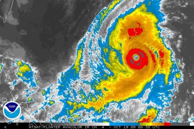
Code: Select all
                     UW - CIMSS
              ADVANCED DVORAK TECHNIQUE
                  ADT-Version 7.2.3
         Tropical Cyclone Intensity Algorithm

             ----- Current Analysis -----
     Date :  19 OCT 2009    Time : 003000 UTC
      Lat :   18:40:59 N     Lon :  133:54:50 E


                CI# /Pressure/ Vmax
                7.0 / 899.7mb/140.0kt


             Final T#  Adj T#  Raw T#
             (3hr avg)
                6.7     6.8     6.8
Doesn't seem to have ingested any of the dry air, or whatever it did ingest wasn't enough to impede the convection. That's not a good sign if you want it to weaken.
0 likes
-
metenthusiast

- Category 1

- Posts: 271
- Age: 48
- Joined: Sun Oct 18, 2009 1:09 am
- Location: Manila, Phllippines
- Contact:
Re: WPAC: TYPHOON LUPIT (22W)
ozonepete wrote:It is pretty clear it's making a turn now, and a fairly tight one. Also, this looks quite impressive to me right now. The central convective core and the eye are very impressive. I'm on board with 135 knots. Look at the CIMSS numbers:Code: Select all
                     UW - CIMSS
              ADVANCED DVORAK TECHNIQUE
                  ADT-Version 7.2.3
         Tropical Cyclone Intensity Algorithm

             ----- Current Analysis -----
     Date :  19 OCT 2009    Time : 003000 UTC
      Lat :   18:40:59 N     Lon :  133:54:50 E


                CI# /Pressure/ Vmax
                7.0 / 899.7mb/140.0kt


             Final T#  Adj T#  Raw T#
             (3hr avg)
                6.7     6.8     6.8
Doesn't seem to have ingested any of the dry air, or whatever it did ingest wasn't enough to impede the convection. That's not a good sign if you want it to weaken.
So it's really turning now? And that the tight turn you've mentioned got me a bit worried. Would that mean it could follow a deeper more SW path bringing it closer to central Luzon?
0 likes
-
metenthusiast
- Category 1
- Posts: 271
- Age: 48
- Joined: Sun Oct 18, 2009 1:09 am
- Location: Manila, Phllippines
- Contact:
Re:
oaba09 wrote:So this officially a Cat 5? What category will this be when it makes landfall..
It's a beautiful system(not as beautiful as rick)....It's just too bad that it has to hit land and cause massive devastation....
I think its already a Cat 5 and yes it's quite beautiful. I saw sat images of rick and was actually mesmerized by it. (I guess that does that for novice observers like me
0 likes
-
ozonepete
- Professional-Met
- Posts: 4743
- Joined: Mon Sep 07, 2009 3:23 pm
- Location: From Ozone Park, NYC / Now in Brooklyn, NY
Re: Re:
metenthusiast wrote:oaba09 wrote:So this officially a Cat 5? What category will this be when it makes landfall..
It's a beautiful system(not as beautiful as rick)....It's just too bad that it has to hit land and cause massive devastation....
I think its already a Cat 5 and yes it's quite beautiful. I saw sat images of rick and was actually mesmerized by it. (I guess that does that for novice observers like me)
Actually, NO, it's not a cat 5. Cat 5 means GREATER THAN than 155 mph or 135 knots. Since the JTWC has it at 135 knots (as cycloneye just posted) this is just slightly under cat 5. Remember that cat 1-5 is the Safir-Simpson scale, and that's not used in the WestPac. They just use typhoon and super typhoon, with super typhoon being greater than 130 knots or 150mph.
0 likes
-
metenthusiast
- Category 1
- Posts: 271
- Age: 48
- Joined: Sun Oct 18, 2009 1:09 am
- Location: Manila, Phllippines
- Contact:
Re: WPAC: TYPHOON LUPIT (22W)
I am watching this:
http://www.ssd.noaa.gov/mtsat/wpac/loop-ir4.html
ans it seems starting to make its move NW-ward. My questions is that would it be possible that it could turn on a more sharper angle than forecasted, bringing it on a more WSW-path towards Central Luzon?
http://www.ssd.noaa.gov/mtsat/wpac/loop-ir4.html
ans it seems starting to make its move NW-ward. My questions is that would it be possible that it could turn on a more sharper angle than forecasted, bringing it on a more WSW-path towards Central Luzon?
0 likes
-
ozonepete
- Professional-Met
- Posts: 4743
- Joined: Mon Sep 07, 2009 3:23 pm
- Location: From Ozone Park, NYC / Now in Brooklyn, NY
Re: WPAC: TYPHOON LUPIT (22W)
metenthusiast wrote:
So it's really turning now? And that the tight turn you've mentioned got me a bit worried. Would that mean it could follow a deeper more SW path bringing it closer to central Luzon?
No. A pretty tight turn was forecasted. The current forecast track still seems reasonable, which means northern Luzon has the most to worry about. And it's still 3 days away. A lot can change between now and then.
0 likes
-
metenthusiast
- Category 1
- Posts: 271
- Age: 48
- Joined: Sun Oct 18, 2009 1:09 am
- Location: Manila, Phllippines
- Contact:
Re: Re:
ozonepete wrote:metenthusiast wrote:oaba09 wrote:So this officially a Cat 5? What category will this be when it makes landfall..
It's a beautiful system(not as beautiful as rick)....It's just too bad that it has to hit land and cause massive devastation....
I think its already a Cat 5 and yes it's quite beautiful. I saw sat images of rick and was actually mesmerized by it. (I guess that does that for novice observers like me
Actually, NO, it's not a cat 5. Cat 5 means GREATER THAN than 155 mph or 135 knots. Since the JTWC has it at 135 knots (as cycloneye just posted) this is just slightly under cat 5. Remember that cat 1-5 is the Safir-Simpson scale, and that's not used in the WestPac. They just use typhoon and super typhoon, with super typhoon being greater than 130 knots or 150mph.
Oh... thanks, sir, for clarifying that to me.
0 likes


-
ozonepete
- Professional-Met
- Posts: 4743
- Joined: Mon Sep 07, 2009 3:23 pm
- Location: From Ozone Park, NYC / Now in Brooklyn, NY
Re:
HURAKAN wrote:
Beautiful storm
Wow! Thanks for that image, Hurakan. Look at the symmetry, and you can see mesovortices in the eye. Pretty much the rule that only a cat 4 or 5 can have those.
0 likes
-
metenthusiast
- Category 1
- Posts: 271
- Age: 48
- Joined: Sun Oct 18, 2009 1:09 am
- Location: Manila, Phllippines
- Contact:
Re: WPAC: TYPHOON LUPIT (22W)
ozonepete wrote:metenthusiast wrote:
So it's really turning now? And that the tight turn you've mentioned got me a bit worried. Would that mean it could follow a deeper more SW path bringing it closer to central Luzon?
No. A pretty tight turn was forecasted. The current forecast track still seems reasonable, which means northern Luzon has the most to worry about. And it's still 3 days away. A lot can change between now and then.
I just hope that changes would be for the better. And since it has started to make its turn (and probably eliminating the possibility of its turning away completely to the east or northeast), I also hope that it tracks higher so that it would lessen its effects on Luzon. (would it?)
But if the current forecast would prevail, and with a size like that, I think Metro Manila has something to worry about.
0 likes
-
oaba09
- S2K Supporter

- Posts: 1496
- Age: 39
- Joined: Thu Oct 01, 2009 10:02 am
- Location: Valenzuela, Philippines
- Contact:
Re: WPAC: TYPHOON LUPIT (22W)
metenthusiast wrote:ozonepete wrote:metenthusiast wrote:
So it's really turning now? And that the tight turn you've mentioned got me a bit worried. Would that mean it could follow a deeper more SW path bringing it closer to central Luzon?
No. A pretty tight turn was forecasted. The current forecast track still seems reasonable, which means northern Luzon has the most to worry about. And it's still 3 days away. A lot can change between now and then.
I just hope that changes would be for the better. And since it has started to make its turn (and probably eliminating the possibility of its turning away completely to the east or northeast), I also hope that it tracks higher so that it would lessen its effects on Luzon. (would it?)
But if the current forecast would prevail, and with a size like that, I think Metro Manila has something to worry about.
My thoughts too
0 likes
-
metenthusiast
- Category 1
- Posts: 271
- Age: 48
- Joined: Sun Oct 18, 2009 1:09 am
- Location: Manila, Phllippines
- Contact:
Re: Re:
oaba09 wrote:HURAKAN wrote:
Beautiful storm
HUGE storm
Yup, very large indeed. I think it's 905 km (490 nm) in size. That almost covers more than half of Luzon.
0 likes
-
metenthusiast
- Category 1
- Posts: 271
- Age: 48
- Joined: Sun Oct 18, 2009 1:09 am
- Location: Manila, Phllippines
- Contact:
Re: WPAC: TYPHOON LUPIT (22W)
oaba09 wrote:
My thoughts too
Indeed. When Ondoy (Ketsana) hit the metro (and its only a tropical storm when it hit, packing 55-75 kph winds) I was forced to cancel my dialysis treatment due to severe flooding. I have my treatment scheduled on Thursday. I just hope to God I am not forced to cancel that again...
0 likes
-
ozonepete
- Professional-Met
- Posts: 4743
- Joined: Mon Sep 07, 2009 3:23 pm
- Location: From Ozone Park, NYC / Now in Brooklyn, NY
Re: WPAC: TYPHOON LUPIT (22W)
Still 3 days until the first possible landfall. You just have to watch it and be prepared.
0 likes
Who is online
Users browsing this forum: No registered users and 27 guests