
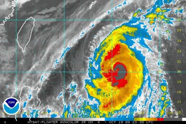
metenthusiast wrote:What does it mean? Is it bad or good?
Good, it's weakening
Moderator: S2k Moderators
ricmood wrote:Hoping it will be down to tropical storm by the time it hits land


CrazyC83 wrote:Probably quite generous. Weakening pretty fast, just like Rick is. I would guess about 90 kt.
(Don't underestimate it though - a Category 2 can still be extremely dangerous, Morakot was only a Cat 2 when it hit Taiwan)
Typhoon10 wrote:OzonePeter, read your latest post. Are you saying the conditions are changing to favour a more Northerly track for Lupit towards HongKong and storm to retain its strength?

leanne_uk wrote::uarrow: as always ozonepete, great work and very interesting points made. I think its showing signs of re strengthening too but i am an a novice at this and my knowledge is nothing more than basic. Conditions are becoming more favourable but its only going to become how apparent them changes are and how they will effect lupit over the next 8-12 hours and further beyond.
I think the typhoon reason this year has been incredibly interesting to monitor and have produced a few amazing systems but maybe ive paid it more attention due to the quiet atlantic season lol

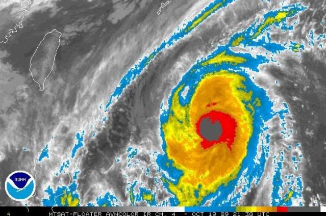
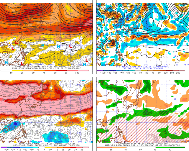
ozonepete wrote:The JTWC REALLY has to be more careful, especially with a strong typhoon that has a lot of people nervous. Look at this excerpt from their latest 192100 prognostic reasoning. They really have to be more careful...
REMARKS:
192100Z POSITION NEAR 19.9N 131.0E.
TYPHOON (TY) 22W (LUPIT), LOCATED APPROXIMATELY 675 NM EAST-NORTHEAST OF MANILA, PHILIPPINES, HAS RACKED WEST-NORTHWESTWARD AT 09 KNOTS OVER THE PAST SIX HOURS. THE CURRENT POSITION AND INTENSITY ESTIMATES ARE CONSISTENT WITH RECENT DVORAK SATELLITE FIXES FROM PGTW AND RJTD. TY 22W IS TRACKING EAST-NORTH EASTWARD UNDER THE STEERING INFLUENCE OF A SUBTROPICAL RIDGE EXTENSION TO THE NORTHEAST OF THE CYCLONE.
oaba09 wrote:ozonepete wrote:The JTWC REALLY has to be more careful, especially with a strong typhoon that has a lot of people nervous. Look at this excerpt from their latest 192100 prognostic reasoning. They really have to be more careful...
REMARKS:
192100Z POSITION NEAR 19.9N 131.0E.
TYPHOON (TY) 22W (LUPIT), LOCATED APPROXIMATELY 675 NM EAST-NORTHEAST OF MANILA, PHILIPPINES, HAS RACKED WEST-NORTHWESTWARD AT 09 KNOTS OVER THE PAST SIX HOURS. THE CURRENT POSITION AND INTENSITY ESTIMATES ARE CONSISTENT WITH RECENT DVORAK SATELLITE FIXES FROM PGTW AND RJTD. TY 22W IS TRACKING EAST-NORTH EASTWARD UNDER THE STEERING INFLUENCE OF A SUBTROPICAL RIDGE EXTENSION TO THE NORTHEAST OF THE CYCLONE.
That actually confused me the 1st time.................I only realized that it's a mistake after a couple times of reading it....
I think Lupit is starting to stabilize into a westward motion....what do you think?
Here's the link:
http://www.wunderground.com/wundermap/? ... fd=0&pix=0


ozonepete wrote:oaba09 wrote:ozonepete wrote:The JTWC REALLY has to be more careful, especially with a strong typhoon that has a lot of people nervous. Look at this excerpt from their latest 192100 prognostic reasoning. They really have to be more careful...
REMARKS:
192100Z POSITION NEAR 19.9N 131.0E.
TYPHOON (TY) 22W (LUPIT), LOCATED APPROXIMATELY 675 NM EAST-NORTHEAST OF MANILA, PHILIPPINES, HAS RACKED WEST-NORTHWESTWARD AT 09 KNOTS OVER THE PAST SIX HOURS. THE CURRENT POSITION AND INTENSITY ESTIMATES ARE CONSISTENT WITH RECENT DVORAK SATELLITE FIXES FROM PGTW AND RJTD. TY 22W IS TRACKING EAST-NORTH EASTWARD UNDER THE STEERING INFLUENCE OF A SUBTROPICAL RIDGE EXTENSION TO THE NORTHEAST OF THE CYCLONE.
That actually confused me the 1st time.................I only realized that it's a mistake after a couple times of reading it....
I think Lupit is starting to stabilize into a westward motion....what do you think?
Here's the link:
http://www.wunderground.com/wundermap/? ... fd=0&pix=0
Weather Underground is OK, but they are not comparable to the NHC, JTWC or JMA. I don't think their forecasts are very original - just a rehash of the better forecasts we get from the aforementioned.
Also, I don't see the westward motion yet at all. I just don't see it. West-northwest yes, but not west.
Users browsing this forum: No registered users and 19 guests

