Hurricane in Western Caribbean?

This is the general tropical discussion area. Anyone can take their shot at predicting a storms path.

Moderator: S2k Moderators

Forum rules

The posts in this forum are NOT official forecasts and should not be used as such. They are just the opinion of the poster and may or may not be backed by sound meteorological data. They are NOT endorsed by any professional institution or STORM2K. For official information, please refer to products from the National Hurricane Center and National Weather Service.

Help Support Storm2K
Message
Author
leanne_uk
Tropical Storm
Tropical Storm
Posts: 214
Age: 42
Joined: Fri Sep 04, 2009 4:38 pm
Location: Loughborough countryside, Leicestershire, UK

Re: Re:

#201 Postby leanne_uk » Mon Oct 19, 2009 7:27 pm

wxman57 wrote:
leanne_uk wrote:got our code yellow on this not suprisingly tho think we all expected that. Even tho conditions are favourable i am not holding my breath for a good development into a cane. You never know and models are supporting it happening but how often has that happened so far this season.
Its all a wait and see situation :)


How would it be "good" if it developed into a hurricane in the Caribbean, where it would almost certainly hit land and kill people?

I apologise using the term good in relation to a cane developing in an area where it could cause damage to anyones homes, business and lives. It was never intended in anyway to upset anyone nor cause offence and the fact it has been saw that way is like i said totally my fault for not wording my statement correctly. The development of systems, how and where they develop at any point in the year especially during the hurricane reason is what interests me and my wording was only based on watching what the system will do and watching development if any. I would never and have never wanted a system to develop and head towards land and people.
Again i do apologise for not wording my statement properly.
0 likes   

User avatar
Evil Jeremy
S2K Supporter
S2K Supporter
Posts: 5463
Age: 32
Joined: Mon Apr 10, 2006 2:10 pm
Location: Los Angeles, CA

Re:

#202 Postby Evil Jeremy » Mon Oct 19, 2009 7:30 pm

Derek Ortt wrote:and add a lot more work for me


Still though, its not as much work overall than in previous seasons lol.
0 likes   
Frances 04 / Jeanne 04 / Katrina 05 / Wilma 05 / Fay 08 / Debby 12 / Andrea 13 / Colin 16 / Hermine 16 / Matthew 16 / Irma 17

User avatar
cycloneye
Admin
Admin
Posts: 145327
Age: 68
Joined: Thu Oct 10, 2002 10:54 am
Location: San Juan, Puerto Rico

Re: Hurricane in Western Caribbean?

#203 Postby cycloneye » Mon Oct 19, 2009 7:38 pm

This will be a slow step by step proccess.First step,getting model support from more than one model.Second,it got a code yellow.The third step is getting invest status,but when that may occur is not known at this point.
0 likes   
Visit the Caribbean-Central America Weather Thread where you can find at first post web cams,radars
and observations from Caribbean basin members Click Here

User avatar
Macrocane
Category 5
Category 5
Posts: 4218
Age: 36
Joined: Sun May 24, 2009 5:35 pm
Location: El Salvador

Re: Re:

#204 Postby Macrocane » Mon Oct 19, 2009 7:39 pm

leanne_uk wrote: I apologise using the term good in relation to a cane developing in an area where it could cause damage to anyones homes, business and lives. It was never intended in anyway to upset anyone nor cause offence and the fact it has been saw that way is like i said totally my fault for not wording my statement correctly. The development of systems, how and where they develop at any point in the year especially during the hurricane reason is what interests me and my wording was only based on watching what the system will do and watching development if any. I would never and have never wanted a system to develop and head towards land and people.
Again i do apologise for not wording my statement properly.


Don't worry, I think some of us understood what you tried to say, but wxman57 gets always a little annoyed when people say that a hurricane looks good or that a hurricane is exciting, and I kind of agree with him because those words can be missundertood or hurt some people's sensitivity, so "interesting" is a better word to avoid confussions.
0 likes   

User avatar
MortisFL
Category 1
Category 1
Posts: 391
Age: 42
Joined: Mon Jul 21, 2003 9:01 am
Location: Sarasota, FL
Contact:

Re: Re:

#205 Postby MortisFL » Mon Oct 19, 2009 7:49 pm

wxman57 wrote:
leanne_uk wrote:got our code yellow on this not suprisingly tho think we all expected that. Even tho conditions are favourable i am not holding my breath for a good development into a cane. You never know and models are supporting it happening but how often has that happened so far this season.
Its all a wait and see situation :)


How would it be "good" if it developed into a hurricane in the Caribbean, where it would almost certainly hit land and kill people?


He said "good development"...not that it would be good for a storm to hit land and kill people.
0 likes   

User avatar
Ivanhater
Storm2k Moderator
Storm2k Moderator
Posts: 11161
Age: 38
Joined: Fri Jul 01, 2005 8:25 am
Location: Pensacola

Re: Hurricane in Western Caribbean?

#206 Postby Ivanhater » Mon Oct 19, 2009 8:00 pm

8-10 Day Ensemble mean. I really don't see this being driven in to Central America, but who knows

Image
0 likes   
Michael

User avatar
Blown Away
S2K Supporter
S2K Supporter
Posts: 10146
Joined: Wed May 26, 2004 6:17 am

Re: Hurricane in Western Caribbean?

#207 Postby Blown Away » Mon Oct 19, 2009 8:05 pm

Image
Image

I'm not seeing the "Low" down near 11.5N/82W, to me it seems there is a general cyclonic rotation around an area near 14N/82W, which is closer to the deeper convection. Is it just me? :double:
0 likes   
Hurricane Eye Experience: David 79, Irene 99, Frances 04, Jeanne 04, Wilma 05... EYE COMING MY WAY IN 2024…
Hurricane Brush Experience: Andrew 92, Erin 95, Floyd 99, Matthew 16, Irma 17, Ian 22, Nicole 22…

User avatar
Nimbus
Category 5
Category 5
Posts: 5300
Joined: Mon Jul 19, 2004 10:54 am

Re: Hurricane in Western Caribbean?

#208 Postby Nimbus » Mon Oct 19, 2009 8:26 pm

It is so cold in Florida after the front went through that I was tempted to drop my tropics folder for the season but this does look interesting. There have been some nasty late October storms like Mitch in 1998. This convection is right at the tail end of the front so if it does cut off it might head into Mexico before having much time to develop.
0 likes   

User avatar
cycloneye
Admin
Admin
Posts: 145327
Age: 68
Joined: Thu Oct 10, 2002 10:54 am
Location: San Juan, Puerto Rico

Re: Hurricane in Western Caribbean?

#209 Postby cycloneye » Mon Oct 19, 2009 8:47 pm

This pass was made this evening at 6:55 PM EDT but it missed the SW Caribbean area. :(

Image
0 likes   
Visit the Caribbean-Central America Weather Thread where you can find at first post web cams,radars
and observations from Caribbean basin members Click Here

User avatar
Ivanhater
Storm2k Moderator
Storm2k Moderator
Posts: 11161
Age: 38
Joined: Fri Jul 01, 2005 8:25 am
Location: Pensacola

Re: Hurricane in Western Caribbean?

#210 Postby Ivanhater » Mon Oct 19, 2009 8:51 pm

Image
0 likes   
Michael

User avatar
gatorcane
S2K Supporter
S2K Supporter
Posts: 23691
Age: 47
Joined: Sun Mar 13, 2005 3:54 pm
Location: Boca Raton, FL

#211 Postby gatorcane » Mon Oct 19, 2009 8:56 pm

If you look at the GFS vs. ECMWF this season as far as forecasting long-range syntopics out 7+ days, it does seem the ECMWF has a better track record. Seems the GFS has not seen big troughs in the long-range and has had a leftward bias if you ask me. Bill is a great example of GFS not seeing that trough over the Eastern CONUS in the long-range and had Bill heading west.....towards Florida. The ECMWF long before the GFS showed Bill recurving. In fact not one run of the ECMWF showed Bill heading west of 65W.

What's interesting is that the ECMWF for many runs now in a row, shows not only a tropical system but one that creeps slowly northward into an area of lower heights to the north. Wxman's charts clearly show just how different the GFS and ECMWF are with respect to the future of this area.

BTW, has anybody seen the 12Z UKMET? Looks like it sends this area into Central America and the EPAC. Right now, I think I'll bet against the ECMWF and go with the GFS/UKMET solution -- into Central America.

http://raleighwx.easternuswx.com/models ... tLoop.html
0 likes   

User avatar
Blown Away
S2K Supporter
S2K Supporter
Posts: 10146
Joined: Wed May 26, 2004 6:17 am

Re: Hurricane in Western Caribbean?

#212 Postby Blown Away » Mon Oct 19, 2009 9:16 pm

:uarrow:
I think if this system deepens it will respond more to the trough that will sweep through next week, the ECMWF solution. If the system stays shallow and weak it will go W, GFS.
0 likes   
Hurricane Eye Experience: David 79, Irene 99, Frances 04, Jeanne 04, Wilma 05... EYE COMING MY WAY IN 2024…
Hurricane Brush Experience: Andrew 92, Erin 95, Floyd 99, Matthew 16, Irma 17, Ian 22, Nicole 22…

User avatar
Ivanhater
Storm2k Moderator
Storm2k Moderator
Posts: 11161
Age: 38
Joined: Fri Jul 01, 2005 8:25 am
Location: Pensacola

Re: Hurricane in Western Caribbean?

#213 Postby Ivanhater » Mon Oct 19, 2009 9:30 pm

Looking at the Sat loop, it seems to be strengthening at a faster rate than the models were indicating. Still think it hold off on developing till later though

Image
0 likes   
Michael

jinftl
Category 5
Category 5
Posts: 4312
Joined: Tue Aug 31, 2004 4:47 pm
Location: fort lauderdale, fl

Re: Hurricane in Western Caribbean?

#214 Postby jinftl » Mon Oct 19, 2009 9:35 pm

A NOAA graphic that is prone to be overlooked....they are pegging the likelihood of development in this region as the highest....by a wide margin....than it has been all season...and well above climatolgic norms for the date. And that graphic is showing the odds of development in the next 24 hours....and what we are seeing here is clearly beyond the 24 hour time frame. Dr. Jeff Masters mentioned a 60% chance of a named system in this region in the next week in his blog this morning.

I know that is not saying alot given this season, but no one can deny what the potential of a favorable environment....which is forecast with a sharp drop in shear in the nw caribbean by the end of the week/weekend.....can mean in this region this time of year. History is abundantly clear. And given the tchp (tropical cyclone heat potential) being higher in this region than it has been since at least 2006 in this region at this time of year.....i don't feel i am an alarmist by saying this area needs to be monitored. Should we panic? Without a depression or ts, that would be nuts.

As always, probabilty is against anything significant developing....but someone's going to have to watch out if things defy 'the odds'. Could the season end with a bang? Ida hope that is not the case.

Think this couldn't be a U.S. threat?

Read the lastest NWS Miami Discussion about what might be steering any system in 5 or 6 days:

IN THE EXTENDED PERIOD THURSDAY THROUGH MONDAY, THE SURFACE RIDGE
WILL BEGIN TO SHIFT FARTHER EAST ON FRIDAY INTO THE WEEKEND AS THE
SHORT WAVE IN THE ROCKIES MOVES INTO THE EASTERN STATES AND ITS
ASSOCIATED COLD FRONT WILL APPROACH SOUTH FLORIDA LATE IN THE
WEEKEND. THE GFS WITH EACH SUCCESSIVE MODEL RUN HAS BEEN DEEPENING
THIS TROUGH MORE AGGRESSIVELY.

Latest NOAA graphic once again increases the probability of development:

Image

Image

Ivanhater wrote:Image
0 likes   

User avatar
CourierPR
Category 5
Category 5
Posts: 1335
Age: 71
Joined: Tue Aug 31, 2004 7:53 pm
Location: Pompano Beach, Florida

Re: Hurricane in Western Caribbean?

#215 Postby CourierPR » Mon Oct 19, 2009 9:55 pm

Local WSVN Met., Phil Ferro , just stated that strong upper level shear will keep the system in check. Comments anyone?
0 likes   

jinftl
Category 5
Category 5
Posts: 4312
Joined: Tue Aug 31, 2004 4:47 pm
Location: fort lauderdale, fl

Re: Hurricane in Western Caribbean?

#216 Postby jinftl » Mon Oct 19, 2009 10:00 pm

Nothing against Phil....but if Bryan Norcross said that, it would carry much more weight in my mind (Channel 7 is the station that tethered Alina Ramos....the sexiest tv met in america per maxim magazine....to a tree during hurricane wilma). Clearly the odds at this point....at any point...are against a memorable storm developing. But if Phil is right, is that a function of him knowing his stuff better than some tropical weather mets...or more a function of even a broken clock being wrong twice a day?

Dr. Jeff Masters, at least as of earlier today, would disagree with Phil's shear outlook...the key to all of this, is that we are not talking imminent development....more in the 5-7 day timeframe.

The thunderstorm activity associated with this large and complicated area of disturbed weather is disorganized and under 10 - 30 knots of wind shear, and any development over the next three days will be slow. However, by Friday, wind shear over the Western Caribbean is expected to drop significantly, and development of a tropical depression in the Western Caribbean becomes a more real possibility. Numerous runs over the past few days of all of our reliable global forecast models have shown a tropical depression developing in the Western Caribbean by early next week. The timing, location, and track of such a such a storm are all pretty hazy, but I think there is a 60% chance of a named storm forming in the Western Caribbean sometime in the next 10 days.
http://www.wunderground.com/blog/JeffMa ... rynum=1354

CourierPR wrote:Local WSVN Met., Phil Ferro , just stated that strong upper level shear will keep the system in check. Comments anyone?
0 likes   

User avatar
cycloneye
Admin
Admin
Posts: 145327
Age: 68
Joined: Thu Oct 10, 2002 10:54 am
Location: San Juan, Puerto Rico

Re: Hurricane in Western Caribbean?

#217 Postby cycloneye » Mon Oct 19, 2009 10:18 pm

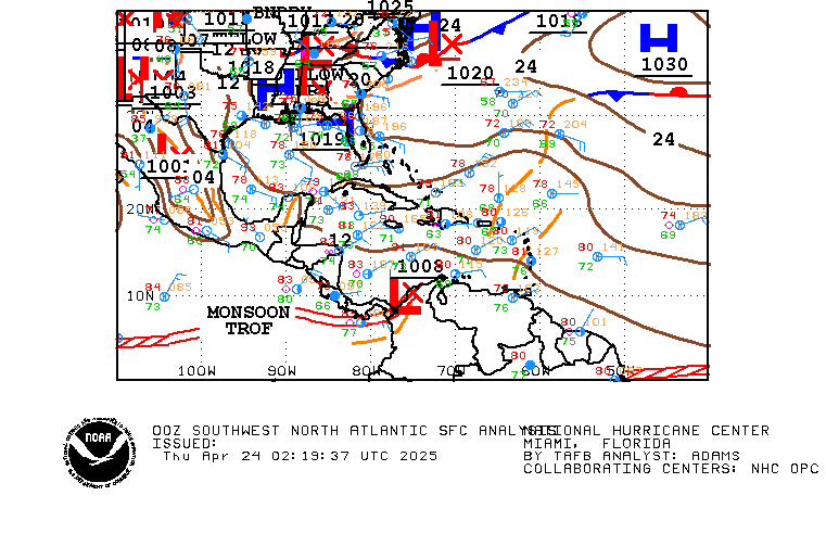
00z Surface Analysis by TAFB lowers the stationary low pressure to 1006 mbs.

Image
0 likes   
Visit the Caribbean-Central America Weather Thread where you can find at first post web cams,radars
and observations from Caribbean basin members Click Here

User avatar
AdamFirst
S2K Supporter
S2K Supporter
Posts: 2491
Age: 36
Joined: Thu Aug 14, 2008 10:54 am
Location: Port Saint Lucie, FL

#218 Postby AdamFirst » Mon Oct 19, 2009 10:27 pm

Local TV met here from NBC 5 (Steve Weagle) says that this has potential for development into this weekend...suggests it will be near Western Cuba at the time. I had no idea about it until now :double:
0 likes   
Dolphins Marlins Canes Golden Panthers HEAT
Andrew 1992 - Irene 1999 - Frances 2004 - Jeanne 2004 - Wilma 2005 - Fay 2008 - Isaac 2012 - Matthew 2016 - Irma 2017 - Dorian 2019 - Ian 2022 - Nicole 2022 - Milton 2024

User avatar
fci
S2K Supporter
S2K Supporter
Posts: 3324
Joined: Tue Sep 14, 2004 10:29 am
Location: Lake Worth, FL

Re:

#219 Postby fci » Mon Oct 19, 2009 11:04 pm

AdamFirst wrote:Local TV met here from NBC 5 (Steve Weagle) says that this has potential for development into this weekend...suggests it will be near Western Cuba at the time. I had no idea about it until now :double:


As Local Mets go, he is the best one we have and not known, IMO; to be an alarmist
0 likes   

Derek Ortt

#220 Postby Derek Ortt » Mon Oct 19, 2009 11:08 pm

didn't see the 18Z GFS posted (and I am not surprised). It showed no development at all, only a broad low
0 likes   


Return to “Talkin' Tropics”

Who is online

Users browsing this forum: NotSparta and 34 guests