http://www.jma.go.jp/en/typh/09205l.html
JMA has a new track and yet it has changed again. This one looks like it has it comming near Okinawa.
WPAC: SEVERE TROPICAL STORM LUPIT (22W)
Moderator: S2k Moderators
-
StormingB81

- S2K Supporter

- Posts: 5676
- Age: 44
- Joined: Thu Aug 27, 2009 1:45 am
- Location: Rockledge, Florida

Re: WPAC: TYPHOON LUPIT (22W)
well, maybe for now but the models seem to be all over the place. If Lupit does hit here I'll be able to document what happens and hopefully get video out in case we need immediate aid.
Jim
Jim
0 likes
-
StormingB81
- S2K Supporter
- Posts: 5676
- Age: 44
- Joined: Thu Aug 27, 2009 1:45 am
- Location: Rockledge, Florida
-
drdavisjr

- Category 1

- Posts: 428
- Age: 58
- Joined: Mon Oct 12, 2009 7:07 am
- Location: Marilao, Bulacan, Philippines
- Contact:
Re: WPAC: TYPHOON LUPIT (22W)
JTE50 wrote:well, maybe for now but the models seem to be all over the place. If Lupit does hit here I'll be able to document what happens and hopefully get video out in case we need immediate aid.
Jim
Good luck, Jim.
0 likes
Re:
StormingB81 wrote:JTE, If it turns from you are guys you going to heads to Tawain or Japan?
Sure, if I can get there but I doubt I would have time.
0 likes
-
drdavisjr
- Category 1
- Posts: 428
- Age: 58
- Joined: Mon Oct 12, 2009 7:07 am
- Location: Marilao, Bulacan, Philippines
- Contact:
Re: Re:
JTE50 wrote:StormingB81 wrote:JTE, If it turns from you are guys you going to heads to Tawain or Japan?
Sure, if I can get there but I doubt I would have time.
Are there alot of press agencies up there?
0 likes
-
Typhoon Hunter
- WesternPacificWeather.com

- Posts: 1222
- Joined: Wed Oct 11, 2006 11:37 am
- Location: Tokyo
- Contact:
Re: WPAC: TYPHOON LUPIT (22W)
CWB and JMA now forecasting Lupit to spare Luzon a landfall and ECMWF has done a complete about turn and also recurve Lupit east of Taiwan. It's only a matter of time before JTWC change their forecast dramatically too. They hinted at this in their latest reasoning.
Jim will be the only foreign press guy up there and he'll be in good position to document Lupit if it does come ashore.
Jim will be the only foreign press guy up there and he'll be in good position to document Lupit if it does come ashore.
0 likes
-
oaba09
- S2K Supporter
- Posts: 1496
- Age: 39
- Joined: Thu Oct 01, 2009 10:02 am
- Location: Valenzuela, Philippines
- Contact:
Re: WPAC: TYPHOON LUPIT (22W)
WTPN31 PGTW 210900
MSGID/GENADMIN/NAVMARFCSTCEN PEARL HARBOR HI/JTWC//
SUBJ/TROPICAL CYCLONE WARNING//
RMKS/
1. TYPHOON 22W (LUPIT) WARNING NR 030
01 ACTIVE TROPICAL CYCLONE IN NORTHWESTPAC
MAX SUSTAINED WINDS BASED ON ONE-MINUTE AVERAGE
WIND RADII VALID OVER OPEN WATER ONLY
---
WARNING POSITION:
210600Z --- NEAR 19.8N 126.3E
MOVEMENT PAST SIX HOURS - 245 DEGREES AT 07 KTS
POSITION ACCURATE TO WITHIN 060 NM
POSITION BASED ON CENTER LOCATED BY SATELLITE
PRESENT WIND DISTRIBUTION:
MAX SUSTAINED WINDS - 080 KT, GUSTS 100 KT
WIND RADII VALID OVER OPEN WATER ONLY
RADIUS OF 064 KT WINDS - 045 NM NORTHEAST QUADRANT
040 NM SOUTHEAST QUADRANT
040 NM SOUTHWEST QUADRANT
045 NM NORTHWEST QUADRANT
RADIUS OF 050 KT WINDS - 070 NM NORTHEAST QUADRANT
065 NM SOUTHEAST QUADRANT
065 NM SOUTHWEST QUADRANT
075 NM NORTHWEST QUADRANT
RADIUS OF 034 KT WINDS - 170 NM NORTHEAST QUADRANT
145 NM SOUTHEAST QUADRANT
160 NM SOUTHWEST QUADRANT
185 NM NORTHWEST QUADRANT
REPEAT POSIT: 19.8N 126.3E
---
FORECASTS:
12 HRS, VALID AT:
211800Z --- 19.3N 125.0E
MAX SUSTAINED WINDS - 085 KT, GUSTS 105 KT
WIND RADII VALID OVER OPEN WATER ONLY
RADIUS OF 064 KT WINDS - 045 NM NORTHEAST QUADRANT
040 NM SOUTHEAST QUADRANT
040 NM SOUTHWEST QUADRANT
045 NM NORTHWEST QUADRANT
RADIUS OF 050 KT WINDS - 075 NM NORTHEAST QUADRANT
065 NM SOUTHEAST QUADRANT
065 NM SOUTHWEST QUADRANT
075 NM NORTHWEST QUADRANT
RADIUS OF 034 KT WINDS - 175 NM NORTHEAST QUADRANT
155 NM SOUTHEAST QUADRANT
165 NM SOUTHWEST QUADRANT
185 NM NORTHWEST QUADRANT
VECTOR TO 24 HR POSIT: 255 DEG/ 05 KTS
---
24 HRS, VALID AT:
220600Z --- 19.0N 123.9E
MAX SUSTAINED WINDS - 090 KT, GUSTS 110 KT
WIND RADII VALID OVER OPEN WATER ONLY
RADIUS OF 064 KT WINDS - 045 NM NORTHEAST QUADRANT
040 NM SOUTHEAST QUADRANT
040 NM SOUTHWEST QUADRANT
045 NM NORTHWEST QUADRANT
RADIUS OF 050 KT WINDS - 080 NM NORTHEAST QUADRANT
070 NM SOUTHEAST QUADRANT
070 NM SOUTHWEST QUADRANT
080 NM NORTHWEST QUADRANT
RADIUS OF 034 KT WINDS - 180 NM NORTHEAST QUADRANT
160 NM SOUTHEAST QUADRANT
170 NM SOUTHWEST QUADRANT
190 NM NORTHWEST QUADRANT
VECTOR TO 36 HR POSIT: 250 DEG/ 05 KTS
---
36 HRS, VALID AT:
221800Z --- 18.7N 123.0E
MAX SUSTAINED WINDS - 090 KT, GUSTS 110 KT
WIND RADII VALID OVER OPEN WATER ONLY
RADIUS OF 064 KT WINDS - 045 NM NORTHEAST QUADRANT
040 NM SOUTHEAST QUADRANT
040 NM SOUTHWEST QUADRANT
045 NM NORTHWEST QUADRANT
RADIUS OF 050 KT WINDS - 080 NM NORTHEAST QUADRANT
070 NM SOUTHEAST QUADRANT
070 NM SOUTHWEST QUADRANT
080 NM NORTHWEST QUADRANT
RADIUS OF 034 KT WINDS - 180 NM NORTHEAST QUADRANT
160 NM SOUTHEAST QUADRANT
170 NM SOUTHWEST QUADRANT
190 NM NORTHWEST QUADRANT
VECTOR TO 48 HR POSIT: 255 DEG/ 04 KTS
---
EXTENDED OUTLOOK:
48 HRS, VALID AT:
230600Z --- 18.5N 122.2E
MAX SUSTAINED WINDS - 080 KT, GUSTS 100 KT
WIND RADII VALID OVER OPEN WATER ONLY
RADIUS OF 064 KT WINDS - 045 NM NORTHEAST QUADRANT
040 NM SOUTHEAST QUADRANT
030 NM SOUTHWEST QUADRANT
045 NM NORTHWEST QUADRANT
RADIUS OF 050 KT WINDS - 075 NM NORTHEAST QUADRANT
065 NM SOUTHEAST QUADRANT
050 NM SOUTHWEST QUADRANT
075 NM NORTHWEST QUADRANT
RADIUS OF 034 KT WINDS - 170 NM NORTHEAST QUADRANT
150 NM SOUTHEAST QUADRANT
135 NM SOUTHWEST QUADRANT
180 NM NORTHWEST QUADRANT
VECTOR TO 72 HR POSIT: 265 DEG/ 03 KTS
---
72 HRS, VALID AT:
240600Z --- 18.4N 121.1E
MAX SUSTAINED WINDS - 070 KT, GUSTS 085 KT
WIND RADII VALID OVER OPEN WATER ONLY
RADIUS OF 064 KT WINDS - 035 NM NORTHEAST QUADRANT
035 NM SOUTHEAST QUADRANT
035 NM SOUTHWEST QUADRANT
035 NM NORTHWEST QUADRANT
RADIUS OF 050 KT WINDS - 065 NM NORTHEAST QUADRANT
050 NM SOUTHEAST QUADRANT
040 NM SOUTHWEST QUADRANT
065 NM NORTHWEST QUADRANT
RADIUS OF 034 KT WINDS - 160 NM NORTHEAST QUADRANT
140 NM SOUTHEAST QUADRANT
140 NM SOUTHWEST QUADRANT
170 NM NORTHWEST QUADRANT
VECTOR TO 96 HR POSIT: 265 DEG/ 02 KTS
---
LONG RANGE OUTLOOK:
NOTE...ERRORS FOR TRACK HAVE AVERAGED NEAR 250 NM
ON DAY 4 AND 350 NM ON DAY 5... AND FOR INTENSITY
NEAR 20 KT EACH DAY.
---
96 HRS, VALID AT:
250600Z --- 18.3N 120.1E
MAX SUSTAINED WINDS - 060 KT, GUSTS 075 KT
WIND RADII VALID OVER OPEN WATER ONLY
VECTOR TO 120 HR POSIT: 265 DEG/ 03 KTS
---
120 HRS, VALID AT:
260600Z --- 18.2N 118.8E
MAX SUSTAINED WINDS - 065 KT, GUSTS 080 KT
WIND RADII VALID OVER OPEN WATER ONLY
---
REMARKS:
210900Z POSITION NEAR 19.7N 126.0E.
TYPHOON (TY) 22W (LUPIT), LOCATED APPROXIMATELY 430 NM NORTHEAST OF
MANILA, PHILIPPINES, HAS TRACKED WEST-SOUTHWESTWARD AT 07 KNOTS OVER
THE PAST SIX HOURS. THE CURRENT POSITION IS BASED ON ANIMATED
MULTISPECTRAL IMAGERY AND THE CURRENT INTENSITY ESTIMATE OF 80 KNOTS
IS CONSISTENT WITH DVORAK T-NUMBER VALUES FROM PGTW, RJTD, AND KNES.
TY 22W IS TRACKING UNDER THE STEERING INFLUENCE OF A SUBTROPICAL
RIDGE EXTENSION TO THE NORTH. THE INTERNAL STRUCTURE OF THE TYPHOON
HAS NOT YET FULLY RECOVERED AFTER CONTENDING WITH A SLOT OF DRIER,
MORE STABLE AIR AND UNDERGOING AN EYEWALL REPLACEMENT CYCLE. THE
TRACK FORECAST FOR TY 22W HAS BECOME MORE UNCERTAIN DUE TO A SPLIT IN
THE NUMERICAL MODEL GUIDANCE. ONE SET OF MODEL SOLUTIONS, INCLUDING
THE WBAR, TCLAPS, AND GFS, DEPICTS A POLEWARD RECURVATURE. A SECOND
SET OF SOLUTIONS, INCLUDING THE ECMWF, JGSM, AND UKMET, SHOWS THE
TYPHOON CONTINUING WESTWARD AS THE SUBTROPICAL STEERING RIDGE TO THE
NORTHWEST REMAINS THE PRIMARY STEERING MECHANISM. THIS SECOND SET OF
SOLUTIONS IS SUPPORTED BY ANALYSIS OF BOTH A PERSISTENT SUBTROPICAL
RIDGE TO THE WEST-NORTHWEST OF TY 22W AND A ZONAL UPSTREAM
MIDLATITUDE FLOW PATTERN. THUS, THE CURRENT FORECAST TRACK FAVORS
THESE WESTWARD-RUNNING MODEL SOLUTIONS. HOWEVER, A SIGNIFICANT SHIFT
IN THE FORECAST MAY BE NECESSARY IF MODEL GUIDANCE AND SYNOPTIC
FEATURES SHIFT IN FAVOR OF THE SLOWER MOTION SCENARIO. LOW VERTICAL
WIND SHEAR AND FAVORABLE OCEAN HEAT CONTENT ARE EXPECTED TO SUPPORT
SOME INTENSIFICATION THROUGH TAU 48, WHEN THE STORM CIRCULATION WILL
BEGIN TO INTERACT WITH TERRAIN OVER NORTHERN LUZON. AS THE WEAKENED
CYCLONE REEMERGES OVER WATER BY TAU 96, FAVORABLY HIGH OCEAN HEAT
CONTENT AND GOOD UPPER LEVEL CONDITIONS SHOULD SUPPORT GRADUAL
REINTENSIFICATION. MAXIMUM SIGNIFICANT WAVE HEIGHT AT 210600Z IS 33
FEET. NEXT WARNINGS AT 211500Z, 212100Z, 220300Z AND 220900Z.//
NNNN
0 likes
-
oaba09
- S2K Supporter
- Posts: 1496
- Age: 39
- Joined: Thu Oct 01, 2009 10:02 am
- Location: Valenzuela, Philippines
- Contact:
Re: WPAC: TYPHOON LUPIT (22W)
JTE50 wrote:well, maybe for now but the models seem to be all over the place. If Lupit does hit here I'll be able to document what happens and hopefully get video out in case we need immediate aid.
Jim
I have a feeling that Lupit will spare aparri.....
0 likes
-
oaba09
- S2K Supporter
- Posts: 1496
- Age: 39
- Joined: Thu Oct 01, 2009 10:02 am
- Location: Valenzuela, Philippines
- Contact:
Re: WPAC: TYPHOON LUPIT (22W)
LATEST FROM PAGASA(pretty similar w/ JTWC)

Typhoon "RAMIL" has maintained its strength as it approaches Northern Luzon.
Location of Center:
(as of 4:00 p.m.) 455 km East Northeast of Aparri, Cagayan
Coordinates: 19.7°N, 126.2°E
Strength: Maximum sustained winds of 175 kph near center
and gustiness of up to 210 kph
Movement: West Southwest at 15 kph
Forecast Positions/Outlook: Thursday afternoon:
130 km East of Aparri, Cagayan or at
230 km East Northeast of Laoag City
Friday afternoon:
vicinity of Laoag City
Saturday afternoon:
165 km West of Laoag City
0 likes
-
drdavisjr
- Category 1
- Posts: 428
- Age: 58
- Joined: Mon Oct 12, 2009 7:07 am
- Location: Marilao, Bulacan, Philippines
- Contact:
Re: WPAC: TYPHOON LUPIT (22W)
oaba09 wrote:JTE50 wrote:well, maybe for now but the models seem to be all over the place. If Lupit does hit here I'll be able to document what happens and hopefully get video out in case we need immediate aid.
Jim
I have a feeling that Lupit will spare aparri.....
I hope, but the storm is still south of forecast track. If it keeps on current track, it would landfall closer to tuguegarao city than aparri. Maybe my eyes are playing tricks on me
0 likes
-
oaba09
- S2K Supporter
- Posts: 1496
- Age: 39
- Joined: Thu Oct 01, 2009 10:02 am
- Location: Valenzuela, Philippines
- Contact:
Re: WPAC: TYPHOON LUPIT (22W)
drdavisjr wrote:oaba09 wrote:JTE50 wrote:well, maybe for now but the models seem to be all over the place. If Lupit does hit here I'll be able to document what happens and hopefully get video out in case we need immediate aid.
Jim
I have a feeling that Lupit will spare aparri.....
I hope, but the storm is still south of forecast track. If it keeps on current track, it would landfall closer to tuguegarao city than aparri. Maybe my eyes are playing tricks on me
Again, the next couple of hours are very critical....We could be looking at a very different path tomorrow morning
0 likes
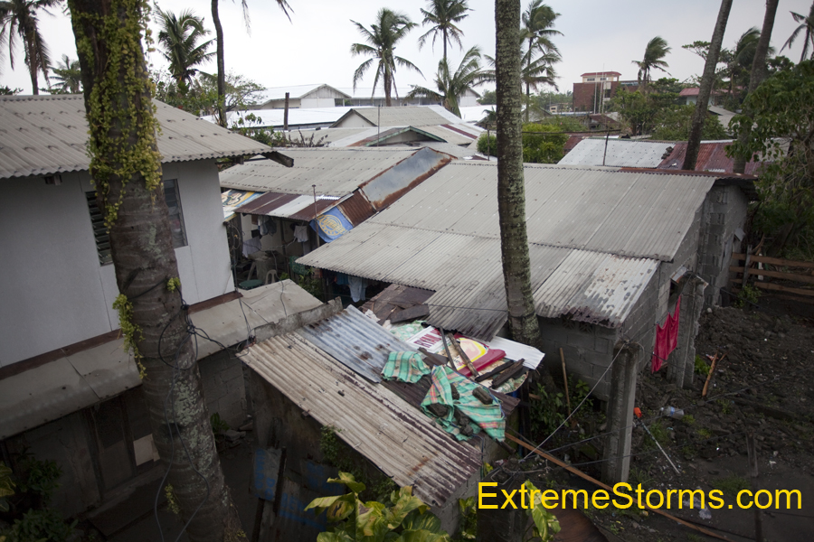
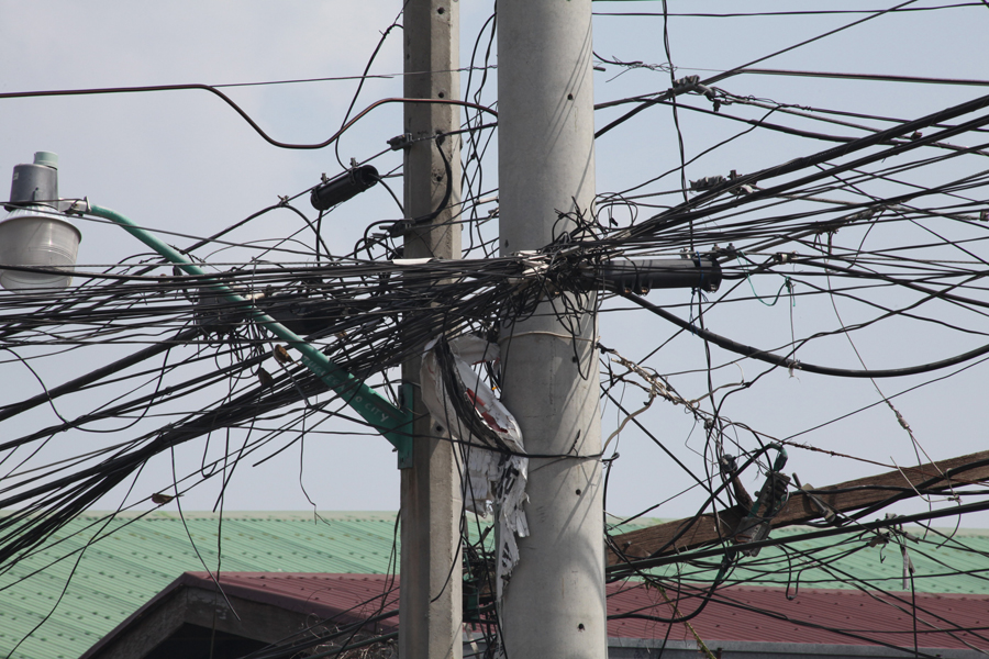
Re: WPAC: TYPHOON LUPIT (22W)
Pics I shot on the way in to Aparri, Philippines yesterday. They rushing to dry the rice on the hot road before Lupit floods the rice patties. View outside my 1 star motel room - and I'm very happy to have a room too! A typical power pole and the main mode of transportation - a 2-cycle modified scooter that smokes like crazy. Costs only 8 pesos to ride. 1 dollar = 46 pesos.


0 likes
-
drdavisjr
- Category 1
- Posts: 428
- Age: 58
- Joined: Mon Oct 12, 2009 7:07 am
- Location: Marilao, Bulacan, Philippines
- Contact:
Re: WPAC: TYPHOON LUPIT (22W)
oaba09 wrote:Again, the next couple of hours are very critical....We could be looking at a very different path tomorrow morning
Very true...I hope so.
0 likes
Re:
oaba09 wrote:^That modified scooter is called a tricycle....Yes, almost all the power poles are like that....WELCOME TO THE PHILIPPINES!!!
Thanks! Yes, the tricycles are very efficient! I'll have some video of the big waves that I shot in a few hours at http://www.weatherzine.net/blog/
That's as soon as Jeff walkes up in Florida and edits it.
0 likes
-
drdavisjr
- Category 1
- Posts: 428
- Age: 58
- Joined: Mon Oct 12, 2009 7:07 am
- Location: Marilao, Bulacan, Philippines
- Contact:
Re: Re:
JTE50 wrote:oaba09 wrote:^That modified scooter is called a tricycle....Yes, almost all the power poles are like that....WELCOME TO THE PHILIPPINES!!!
Thanks! Yes, the tricycles are very efficient! I'll have some video of the big waves that I shot in a few hours at http://www.weatherzine.net/blog/
That's as soon as Jeff walkes up in Florida and edits it.
Nice Wordpress Blog...
0 likes
-
drdavisjr
- Category 1
- Posts: 428
- Age: 58
- Joined: Mon Oct 12, 2009 7:07 am
- Location: Marilao, Bulacan, Philippines
- Contact:
Re: WPAC: TYPHOON LUPIT (22W)
Sorry, I'm a web developer, so 1st I notice the site and layout and THEN its contents 
0 likes
Who is online
Users browsing this forum: No registered users and 16 guests