For the first time JTWC track at 0300z misses Luzon!!.
WTPN31 PGTW 220300
MSGID/GENADMIN/NAVMARFCSTCEN PEARL HARBOR HI/JTWC//
SUBJ/TROPICAL CYCLONE WARNING//
RMKS/
1. TYPHOON 22W (LUPIT) WARNING NR 033
01 ACTIVE TROPICAL CYCLONE IN NORTHWESTPAC
MAX SUSTAINED WINDS BASED ON ONE-MINUTE AVERAGE
WIND RADII VALID OVER OPEN WATER ONLY
---
WARNING POSITION:
220000Z --- NEAR 18.9N 124.8E
MOVEMENT PAST SIX HOURS - 245 DEGREES AT 05 KTS
POSITION ACCURATE TO WITHIN 040 NM
POSITION BASED ON CENTER LOCATED BY SATELLITE
PRESENT WIND DISTRIBUTION:
MAX SUSTAINED WINDS - 080 KT, GUSTS 100 KT
WIND RADII VALID OVER OPEN WATER ONLY
RADIUS OF 064 KT WINDS - 045 NM NORTHEAST QUADRANT
040 NM SOUTHEAST QUADRANT
040 NM SOUTHWEST QUADRANT
045 NM NORTHWEST QUADRANT
RADIUS OF 050 KT WINDS - 070 NM NORTHEAST QUADRANT
065 NM SOUTHEAST QUADRANT
065 NM SOUTHWEST QUADRANT
075 NM NORTHWEST QUADRANT
RADIUS OF 034 KT WINDS - 145 NM NORTHEAST QUADRANT
175 NM SOUTHEAST QUADRANT
160 NM SOUTHWEST QUADRANT
185 NM NORTHWEST QUADRANT
REPEAT POSIT: 18.9N 124.8E
---
FORECASTS:
12 HRS, VALID AT:
221200Z --- 18.7N 124.3E
MAX SUSTAINED WINDS - 080 KT, GUSTS 100 KT
WIND RADII VALID OVER OPEN WATER ONLY
RADIUS OF 064 KT WINDS - 040 NM NORTHEAST QUADRANT
035 NM SOUTHEAST QUADRANT
035 NM SOUTHWEST QUADRANT
040 NM NORTHWEST QUADRANT
RADIUS OF 050 KT WINDS - 065 NM NORTHEAST QUADRANT
060 NM SOUTHEAST QUADRANT
060 NM SOUTHWEST QUADRANT
070 NM NORTHWEST QUADRANT
RADIUS OF 034 KT WINDS - 130 NM NORTHEAST QUADRANT
150 NM SOUTHEAST QUADRANT
140 NM SOUTHWEST QUADRANT
160 NM NORTHWEST QUADRANT
VECTOR TO 24 HR POSIT: 250 DEG/ 02 KTS
---
24 HRS, VALID AT:
230000Z --- 18.6N 124.0E
MAX SUSTAINED WINDS - 085 KT, GUSTS 105 KT
WIND RADII VALID OVER OPEN WATER ONLY
RADIUS OF 064 KT WINDS - 040 NM NORTHEAST QUADRANT
035 NM SOUTHEAST QUADRANT
035 NM SOUTHWEST QUADRANT
040 NM NORTHWEST QUADRANT
RADIUS OF 050 KT WINDS - 065 NM NORTHEAST QUADRANT
060 NM SOUTHEAST QUADRANT
060 NM SOUTHWEST QUADRANT
065 NM NORTHWEST QUADRANT
RADIUS OF 034 KT WINDS - 130 NM NORTHEAST QUADRANT
140 NM SOUTHEAST QUADRANT
135 NM SOUTHWEST QUADRANT
150 NM NORTHWEST QUADRANT
VECTOR TO 36 HR POSIT: 255 DEG/ 02 KTS
---
36 HRS, VALID AT:
231200Z --- 18.5N 123.6E
MAX SUSTAINED WINDS - 085 KT, GUSTS 105 KT
WIND RADII VALID OVER OPEN WATER ONLY
RADIUS OF 064 KT WINDS - 035 NM NORTHEAST QUADRANT
035 NM SOUTHEAST QUADRANT
035 NM SOUTHWEST QUADRANT
035 NM NORTHWEST QUADRANT
RADIUS OF 050 KT WINDS - 060 NM NORTHEAST QUADRANT
060 NM SOUTHEAST QUADRANT
060 NM SOUTHWEST QUADRANT
065 NM NORTHWEST QUADRANT
RADIUS OF 034 KT WINDS - 130 NM NORTHEAST QUADRANT
135 NM SOUTHEAST QUADRANT
130 NM SOUTHWEST QUADRANT
140 NM NORTHWEST QUADRANT
VECTOR TO 48 HR POSIT: 270 DEG/ 02 KTS
---
EXTENDED OUTLOOK:
48 HRS, VALID AT:
240000Z --- 18.5N 123.1E
MAX SUSTAINED WINDS - 085 KT, GUSTS 105 KT
WIND RADII VALID OVER OPEN WATER ONLY
RADIUS OF 064 KT WINDS - 035 NM NORTHEAST QUADRANT
035 NM SOUTHEAST QUADRANT
035 NM SOUTHWEST QUADRANT
035 NM NORTHWEST QUADRANT
RADIUS OF 050 KT WINDS - 060 NM NORTHEAST QUADRANT
060 NM SOUTHEAST QUADRANT
060 NM SOUTHWEST QUADRANT
060 NM NORTHWEST QUADRANT
RADIUS OF 034 KT WINDS - 130 NM NORTHEAST QUADRANT
130 NM SOUTHEAST QUADRANT
125 NM SOUTHWEST QUADRANT
135 NM NORTHWEST QUADRANT
VECTOR TO 72 HR POSIT: 280 DEG/ 01 KTS
---
72 HRS, VALID AT:
250000Z --- 18.6N 122.6E
MAX SUSTAINED WINDS - 080 KT, GUSTS 100 KT
WIND RADII VALID OVER OPEN WATER ONLY
RADIUS OF 064 KT WINDS - 030 NM NORTHEAST QUADRANT
030 NM SOUTHEAST QUADRANT
030 NM SOUTHWEST QUADRANT
030 NM NORTHWEST QUADRANT
RADIUS OF 050 KT WINDS - 055 NM NORTHEAST QUADRANT
055 NM SOUTHEAST QUADRANT
055 NM SOUTHWEST QUADRANT
055 NM NORTHWEST QUADRANT
RADIUS OF 034 KT WINDS - 125 NM NORTHEAST QUADRANT
120 NM SOUTHEAST QUADRANT
120 NM SOUTHWEST QUADRANT
130 NM NORTHWEST QUADRANT
VECTOR TO 96 HR POSIT: 295 DEG/ 01 KTS
---
LONG RANGE OUTLOOK:
NOTE...ERRORS FOR TRACK HAVE AVERAGED NEAR 250 NM
ON DAY 4 AND 350 NM ON DAY 5... AND FOR INTENSITY
NEAR 20 KT EACH DAY.
---
96 HRS, VALID AT:
260000Z --- 18.8N 122.1E
MAX SUSTAINED WINDS - 075 KT, GUSTS 090 KT
WIND RADII VALID OVER OPEN WATER ONLY
VECTOR TO 120 HR POSIT: 300 DEG/ 01 KTS
---
120 HRS, VALID AT:
270000Z --- 19.1N 121.6E
MAX SUSTAINED WINDS - 075 KT, GUSTS 090 KT
WIND RADII VALID OVER OPEN WATER ONLY
---
REMARKS:
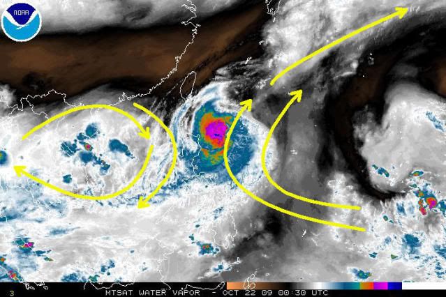
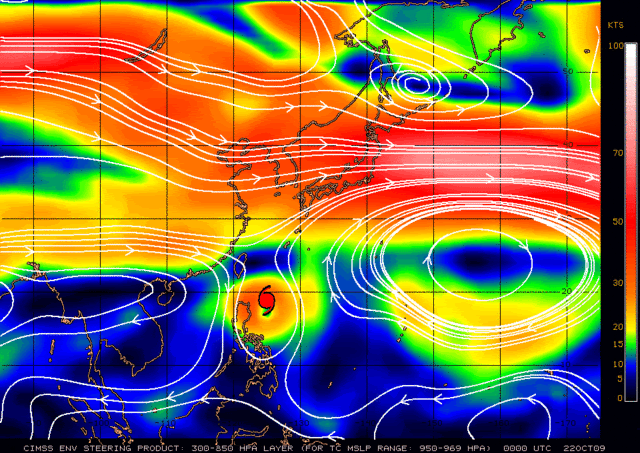
220300Z POSITION NEAR 18.9N 124.7E. TYPHOON 22W (LUPIT), LOCATED
APPROXIMATELY 340 NM NORTHEAST OF MANILA, PHILIPPINES, HAS TRACKED
WEST-SOUTHWESTWARD AT 05 KNOTS OVER THE PAST SIX HOURS. THE SYSTEM
REMAINS IN A WEAK STEERING ENVIRONMENT TRANSITIONING BETWEEN THE
SUBTROPICAL RIDGE (STR) TO THE EAST AND THE STR TO THE WEST.
ANALYSIS SHOWS NORTHWESTERLY FLOW BEGINNING TO WEAKEN THE WESTERN
RIDGE WHICH MAY ALLOW FOR THE STR TO THE EAST TO BECOME THE DOMINANT
INFLUENCE. NUMERICAL MODEL GUIDANCE HAS BEEN ERRATIC AND CURRENTLY
OVERWHELMINGLY FAVORS A POLEWARD TURN BY TAU 24. HOWEVER, CURRENT
ENVIRONMENTAL ANALYSIS OF THE REGION DOES NOT REVEAL A CLEAR PICTURE
OF THE SYNOPTIC STEERING FLOW. IT IS LIKELY THAT THE SYSTEM WILL
REMAIN IN A WEAK ENVIRONMENT THROUGH THE NEXT FEW DAYS. MAXIMUM
SIGNIFICANT WAVE HEIGHT AT 220000Z IS 30 FEET. NEXT WARNINGS AT
220900Z, 221500Z, 222100Z AND 230300Z.//