ATL : INVEST 94L
Moderator: S2k Moderators

-
lrak

- S2K Supporter

- Posts: 1770
- Age: 59
- Joined: Thu Jun 21, 2007 2:48 pm
- Location: Corpus Christi, TX
Re: ATL : INVEST 94L
0 likes
AKA karl
Also
Personal Forecast Disclaimer:
My posts on this forum are NOT official forecast and should not be used as such. My posts are my basic observations and are definitely not backed by any "well some" meteorological knowledge. For official information, please refer to the NHC and NWS products.
Also
Personal Forecast Disclaimer:
My posts on this forum are NOT official forecast and should not be used as such. My posts are my basic observations and are definitely not backed by any "well some" meteorological knowledge. For official information, please refer to the NHC and NWS products.
-
cycloneye

- Admin

- Posts: 149462
- Age: 69
- Joined: Thu Oct 10, 2002 10:54 am
- Location: San Juan, Puerto Rico
Re: ATL : INVEST 94L
lrak wrote:http://www.nhc.noaa.gov/gtwo/gtwo_atl_sub.shtml?area1#contents
still yellow?
Even if the invest has been deactivated,they continue to monitor it and if it starts to show signs of organization,they will upgrade to code orange and the invest is reactivated. But lets not jump ahead and wait and see what happens.
0 likes
Visit the Caribbean-Central America Weather Thread where you can find at first post web cams,radars
and observations from Caribbean basin members Click Here
and observations from Caribbean basin members Click Here
-
lrak
- S2K Supporter
- Posts: 1770
- Age: 59
- Joined: Thu Jun 21, 2007 2:48 pm
- Location: Corpus Christi, TX
Re: ATL : INVEST 94L
Whoops, I need to read a few pages back, I got lost 
0 likes
AKA karl
Also
Personal Forecast Disclaimer:
My posts on this forum are NOT official forecast and should not be used as such. My posts are my basic observations and are definitely not backed by any "well some" meteorological knowledge. For official information, please refer to the NHC and NWS products.
Also
Personal Forecast Disclaimer:
My posts on this forum are NOT official forecast and should not be used as such. My posts are my basic observations and are definitely not backed by any "well some" meteorological knowledge. For official information, please refer to the NHC and NWS products.
-
cycloneye
- Admin
- Posts: 149462
- Age: 69
- Joined: Thu Oct 10, 2002 10:54 am
- Location: San Juan, Puerto Rico
Re: ATL : INVEST 94L
Below is the 00z surface analysis by TAFB.The SW Caribbean low is forecast to stay almost stationary just off the Nicaraguan coast.

http://www.nhc.noaa.gov/marine_forecasts.shtml
http://www.nhc.noaa.gov/marine_forecasts.shtml
0 likes
Visit the Caribbean-Central America Weather Thread where you can find at first post web cams,radars
and observations from Caribbean basin members Click Here
and observations from Caribbean basin members Click Here
-
weatherwindow

- Category 4

- Posts: 904
- Joined: Mon Sep 20, 2004 9:48 am
- Location: key west/ft lauderdale
Re: ATL : INVEST 94L
http://www.nhc.noaa.gov/tafb_latest/atlsfc72_latestBW_sm3.gif......TAFB continues to hang on to the low and moves it nw into the nw carib at the 72hr mark... ahead of a slowing trough over fla... imo it rates our continued interest......rich
0 likes
-
cycloneye
- Admin
- Posts: 149462
- Age: 69
- Joined: Thu Oct 10, 2002 10:54 am
- Location: San Juan, Puerto Rico
Re: ATL : INVEST 94L
TROPICAL WEATHER OUTLOOK
NWS TPC/NATIONAL HURRICANE CENTER MIAMI FL
800 AM EDT THU OCT 22 2009
FOR THE NORTH ATLANTIC...CARIBBEAN SEA AND THE GULF OF MEXICO...
DISORGANIZED CLOUDINESS AND SHOWERS OVER THE SOUTHWESTERN CARIBBEAN
SEA ARE ASSOCIATED WITH A NEARLY-STATIONARY AREA OF LOW PRESSURE.
THERE IS A LOW CHANCE...LESS THAN 30 PERCENT...OF THIS SYSTEM
BECOMING A TROPICAL CYCLONE DURING THE NEXT 48 HOURS.
CLOUDINESS AND SHOWERS OVER PORTIONS OF THE BAHAMAS AND THE ADJACENT
ATLANTIC ARE ASSOCIATED WITH AN UPPER-LEVEL TROUGH AND THE REMNANTS
OF A COLD FRONT. UPPER-LEVEL WINDS ARE EXPECTED TO REMAIN
UNFAVORABLE FOR SIGNIFICANT DEVELOPMENT DURING THE NEXT COUPLE OF
DAYS WHILE THE SYSTEM DRIFTS WESTWARD. THERE IS A LOW CHANCE...
LESS THAN 30 PERCENT...OF THIS SYSTEM BECOMING A TROPICAL OR
SUBTROPICAL CYCLONE DURING THE NEXT 48 HOURS.
ELSEWHERE...TROPICAL CYCLONE FORMATION IS NOT EXPECTED DURING THE
NEXT 48 HOURS.
$$
FORECASTER AVILA
0 likes
Visit the Caribbean-Central America Weather Thread where you can find at first post web cams,radars
and observations from Caribbean basin members Click Here
and observations from Caribbean basin members Click Here
-
Evil Jeremy

- S2K Supporter
- Posts: 5463
- Age: 32
- Joined: Mon Apr 10, 2006 2:10 pm
- Location: Los Angeles, CA
Re: ATL : INVEST 94L
Looks like Avila forgot to copy/paste the parts about the conditions in the area and the rain to nearby areas lol. Either way, this is still looking bad this morning.
0 likes
Frances 04 / Jeanne 04 / Katrina 05 / Wilma 05 / Fay 08 / Debby 12 / Andrea 13 / Colin 16 / Hermine 16 / Matthew 16 / Irma 17
-
wxman57

- Moderator-Pro Met

- Posts: 23174
- Age: 68
- Joined: Sat Jun 21, 2003 8:06 pm
- Location: Houston, TX (southwest)
Re: ATL : INVEST 94L
I'm encouraged by what I see this morning. Was just a tad more concerned last night when I saw that little vortex near 12.9N/79.5W. But today, convection is focused back in the east Pacific, and I think that's where anything will develop out of this. Still no model support for development in the west Caribbean. GFS still tries to spin up a weak low then dissipates it.
It's something to keep an eye on until it's gone, but I'm not too concerned about it at this point.
It's something to keep an eye on until it's gone, but I'm not too concerned about it at this point.
0 likes
-
MGC

- S2K Supporter
- Posts: 5940
- Joined: Sun Mar 23, 2003 9:05 pm
- Location: Pass Christian MS, or what is left.
Re: ATL : INVEST 94L
Yep, looks like the action has shifted to EPAC....they can keep it. If it does spin we'll have to watch for a crossover......MGC
0 likes
-
Blown Away

- S2K Supporter
- Posts: 10253
- Joined: Wed May 26, 2004 6:17 am
Re: ATL : INVEST 94L
Still looks pathetic, but there is still a little rotation and convection around the low located rate on the coast. The EPAC convection looked good earlier this morning, but that is starting to fade. I'm looking on the visible today for the MLC that was spotted just off the coast in one of the last visible shots yesterday.
0 likes
Hurricane Eye Experience: David 79, Irene 99, Frances 04, Jeanne 04, Wilma 05… Hurricane Brush Experience: Andrew 92, Erin 95, Floyd 99, Matthew 16, Irma 17, Ian 22, Nicole 22…


Re: ATL : INVEST 94L
The convection looks much better on the EPAC side today. The only thing is seems to be missing is the convergence.

0 likes
-
cycloneye
- Admin
- Posts: 149462
- Age: 69
- Joined: Thu Oct 10, 2002 10:54 am
- Location: San Juan, Puerto Rico
Re: ATL : INVEST 94L
Below is todays discussion of the SW Caribbean area by Dr Jeff Masters.He still insists that a TD will form in the next ten days.
Posted by: JeffMasters, 1:49 PM GMT on October 22, 2009
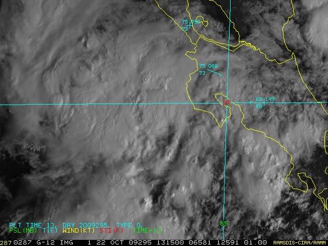
A broad 1009 mb low pressure area is over the Southwest Caribbean near 12N 83W, off the coast of Nicaragua. This low, in combination with an upper-level trough of low pressure, is generating some disorganized heavy thunderstorm activity over the Western Caribbean and Central America. A second 1008 mb low pressure area is over the Pacific Ocean near the coast of Costa Rica. The two lows appear to be competing with each other, with the result that the organization of the thunderstorm activity over the region is less than yesterday's. Recent satellite loops show little change in the areal coverage or intensity of the thunderstorms this morning. NHC designated this disturbance Invest 94L on Tuesday, but is no longer issuing model products for it. This morning's QuikSCAT pass missed the Western Caribbean, but last night's pass showed no signs of a surface circulation. Wind shear is moderate, about 10 - 20 knots, and there is a deep layer of high moisture over the entire Western Caribbean, so we still need to keep an eye on this disturbance. NHC is giving 94L a low (less than 30% chance) of developing into a tropical depression by Saturday. No models predict development of this system over the next seven days, but I'll continue to give a medium (30 - 50% chance) that a Western Caribbean tropical depression will form sometime in the next ten days.
0 likes
Visit the Caribbean-Central America Weather Thread where you can find at first post web cams,radars
and observations from Caribbean basin members Click Here
and observations from Caribbean basin members Click Here
-
Evil Jeremy
- S2K Supporter
- Posts: 5463
- Age: 32
- Joined: Mon Apr 10, 2006 2:10 pm
- Location: Los Angeles, CA
Re: ATL : INVEST 94L
cycloneye wrote:Below is todays discussion of the SW Caribbean area by Dr Jeff Masters.He still insists that a TD will form in the next ten days.Posted by: JeffMasters, 1:49 PM GMT on October 22, 2009
A broad 1009 mb low pressure area is over the Southwest Caribbean near 12N 83W, off the coast of Nicaragua. This low, in combination with an upper-level trough of low pressure, is generating some disorganized heavy thunderstorm activity over the Western Caribbean and Central America. A second 1008 mb low pressure area is over the Pacific Ocean near the coast of Costa Rica. The two lows appear to be competing with each other, with the result that the organization of the thunderstorm activity over the region is less than yesterday's. Recent satellite loops show little change in the areal coverage or intensity of the thunderstorms this morning. NHC designated this disturbance Invest 94L on Tuesday, but is no longer issuing model products for it. This morning's QuikSCAT pass missed the Western Caribbean, but last night's pass showed no signs of a surface circulation. Wind shear is moderate, about 10 - 20 knots, and there is a deep layer of high moisture over the entire Western Caribbean, so we still need to keep an eye on this disturbance. NHC is giving 94L a low (less than 30% chance) of developing into a tropical depression by Saturday. No models predict development of this system over the next seven days, but I'll continue to give a medium (30 - 50% chance) that a Western Caribbean tropical depression will form sometime in the next ten days.
Jeff is very optimistic about this forming in the long term. I don't see anything coming out of this disturbance, on either side of land, in the short term or long term. It does look like there is a circulation forming with the epac part of the disturbance, but I expect it to poof out, just like yesterday.
0 likes
Frances 04 / Jeanne 04 / Katrina 05 / Wilma 05 / Fay 08 / Debby 12 / Andrea 13 / Colin 16 / Hermine 16 / Matthew 16 / Irma 17
Re: ATL : INVEST 94L
Just like yesterday there looks like there is a small MLC off the Nicaraguan coast, you can see some of the lower clouds being pulled in that direction. If the EPAC can develop some inflow it should kill this off though...

0 likes

Re: ATL : INVEST 94L
I have a feeling that even if it did stay in the Caribbean the 2009 conditions would have dried it out.
Frank 2 wins. 2009 is not a normal season as far as looking at the satellite image and predicting development.
Toast.
Frank 2 wins. 2009 is not a normal season as far as looking at the satellite image and predicting development.
Toast.
0 likes
-
cycloneye
- Admin
- Posts: 149462
- Age: 69
- Joined: Thu Oct 10, 2002 10:54 am
- Location: San Juan, Puerto Rico
Re: ATL : INVEST 94L
No changes in the 12z surface analysis from the past ones.Still the duo lows in the same places.
0 likes
Visit the Caribbean-Central America Weather Thread where you can find at first post web cams,radars
and observations from Caribbean basin members Click Here
and observations from Caribbean basin members Click Here
Re: ATL : INVEST 94L
Sanibel wrote:I have a feeling that even if it did stay in the Caribbean the 2009 conditions would have dried it out.
Frank 2 wins. 2009 is not a normal season as far as looking at the satellite image and predicting development.
Toast.
Yeah, while we were looking at some puffy cumulonimbus clouds over Panama, somebody in the Pacific flipped the switch on http://www.longpaddock.qld.gov.au/SeasonalClimateOutlook/SouthernOscillationIndex/30DaySOIValues/
Code: Select all
  16-Oct-2009    1012.50   1011.50    -12.19     -1.25     -1.60
  17-Oct-2009    1009.51   1011.70    -32.75     -2.96     -2.06
  18-Oct-2009    1008.19   1011.70    -41.26     -4.79     -2.55
  19-Oct-2009    1008.76   1012.10    -40.16     -6.21     -2.93
  20-Oct-2009    1010.43   1012.55    -32.30     -7.32     -3.28
  21-Oct-2009    1011.07   1012.70    -29.14     -8.48     -3.61
  22-Oct-2009    1011.96   1012.80    -24.05     -9.71     -3.84
That is some serious SOI, the Nino is going to be cranking the jet.
0 likes

Re: ATL : INVEST 94L
Convection seems to be increasing off the east coast of Nic today. Latest 200 mb upper level winds look favorable for development in the NW caribbean sea in 3-5 days as a small upper level high builds in. Anything that does develop looks to be steered up into the eastern GOM along the west coast of FL by Tuesday or Wednesday next week.

0 likes
Who is online
Users browsing this forum: No registered users and 14 guests