
ATL : INVEST 94L
Moderator: S2k Moderators
-
Evil Jeremy

- S2K Supporter

- Posts: 5463
- Age: 32
- Joined: Mon Apr 10, 2006 2:10 pm
- Location: Los Angeles, CA
Re: ATL : INVEST 94L
Lower level convergence increasing in the Caribbean, and convection is popping in that area. Meanwhile, the epac part of the disturbance is fading out again, just like yesterday.
0 likes
Frances 04 / Jeanne 04 / Katrina 05 / Wilma 05 / Fay 08 / Debby 12 / Andrea 13 / Colin 16 / Hermine 16 / Matthew 16 / Irma 17


-
Blown Away

- S2K Supporter
- Posts: 10253
- Joined: Wed May 26, 2004 6:17 am
Re: ATL : INVEST 94L
0 likes
Hurricane Eye Experience: David 79, Irene 99, Frances 04, Jeanne 04, Wilma 05… Hurricane Brush Experience: Andrew 92, Erin 95, Floyd 99, Matthew 16, Irma 17, Ian 22, Nicole 22…
-
cycloneye

- Admin

- Posts: 149275
- Age: 69
- Joined: Thu Oct 10, 2002 10:54 am
- Location: San Juan, Puerto Rico
Re: ATL : INVEST 94L

0 likes
Visit the Caribbean-Central America Weather Thread where you can find at first post web cams,radars
and observations from Caribbean basin members Click Here
and observations from Caribbean basin members Click Here

-
cycloneye
- Admin
- Posts: 149275
- Age: 69
- Joined: Thu Oct 10, 2002 10:54 am
- Location: San Juan, Puerto Rico
Re: ATL : INVEST 94L - Models
12z CMC animation.Bullish once again.
http://moe.met.fsu.edu/cgi-bin/cmctc2.c ... =Animation
12z GFS trys to form something in Western Caribbean and moves it into the GOM but is very weak.
http://moe.met.fsu.edu/cgi-bin/gfstc2.c ... =Animation
http://moe.met.fsu.edu/cgi-bin/cmctc2.c ... =Animation
12z GFS trys to form something in Western Caribbean and moves it into the GOM but is very weak.
http://moe.met.fsu.edu/cgi-bin/gfstc2.c ... =Animation
0 likes
Visit the Caribbean-Central America Weather Thread where you can find at first post web cams,radars
and observations from Caribbean basin members Click Here
and observations from Caribbean basin members Click Here
-
cycloneye
- Admin
- Posts: 149275
- Age: 69
- Joined: Thu Oct 10, 2002 10:54 am
- Location: San Juan, Puerto Rico
Re: ATL : INVEST 94L
TROPICAL WEATHER OUTLOOK
NWS TPC/NATIONAL HURRICANE CENTER MIAMI FL
200 PM EDT THU OCT 22 2009
FOR THE NORTH ATLANTIC...CARIBBEAN SEA AND THE GULF OF MEXICO...
CLOUDINESS AND SHOWERS OVER THE SOUTHWESTERN CARIBBEAN SEA ARE
ASSOCIATED WITH A NEARLY-STATIONARY AREA OF LOW PRESSURE JUST OFF
THE EAST COAST OF NICARAGUA. FURTHER DEVELOPMENT...IF ANY...WILL
BE SLOW TO OCCUR. THERE IS A LOW CHANCE...LESS THAN 30 PERCENT...OF
THIS SYSTEM BECOMING A TROPICAL CYCLONE DURING THE NEXT 48 HOURS.
ELSEWHERE...TROPICAL CYCLONE FORMATION IS NOT EXPECTED DURING THE
NEXT 48 HOURS.
$$
FORECASTER AVILA
0 likes
Visit the Caribbean-Central America Weather Thread where you can find at first post web cams,radars
and observations from Caribbean basin members Click Here
and observations from Caribbean basin members Click Here
-
Blown Away
- S2K Supporter
- Posts: 10253
- Joined: Wed May 26, 2004 6:17 am
Re: ATL : INVEST 94L
The timing makes better sense to me I just could not see a system sitting down there for 10+ days like some of the previous models were showing. I believe the low is finally on the move drifting towards the ENE.
0 likes
Hurricane Eye Experience: David 79, Irene 99, Frances 04, Jeanne 04, Wilma 05… Hurricane Brush Experience: Andrew 92, Erin 95, Floyd 99, Matthew 16, Irma 17, Ian 22, Nicole 22…
-
Ivanhater

- Storm2k Moderator

- Posts: 11221
- Age: 39
- Joined: Fri Jul 01, 2005 8:25 am
- Location: Pensacola
Re: ATL : INVEST 94L - Models
12z Ukmet, develops a closed low in the gulf somewhat, which is interesting from this conservative model. Models still sniffing this out down there, with the Canadian the strongest

0 likes
Michael

-
cycloneye
- Admin
- Posts: 149275
- Age: 69
- Joined: Thu Oct 10, 2002 10:54 am
- Location: San Juan, Puerto Rico
Re: ATL : INVEST 94L
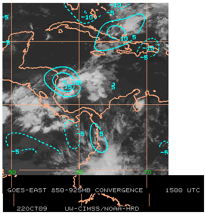
Low level convergence has increased in the area.
0 likes
Visit the Caribbean-Central America Weather Thread where you can find at first post web cams,radars
and observations from Caribbean basin members Click Here
and observations from Caribbean basin members Click Here
Re: ATL : INVEST 94L
The remnant front jacked-up vertically and plunged all the way down to 94L and is inhibiting it. Crazy.
0 likes
-
wxman57

- Moderator-Pro Met

- Posts: 23172
- Age: 68
- Joined: Sat Jun 21, 2003 8:06 pm
- Location: Houston, TX (southwest)
Re: ATL : INVEST 94L
Ivanhater wrote:Surprised no one showed the 12z CMC
http://moe.met.fsu.edu/tcgengifs/cmc/20 ... /slp20.png
GFS shows something similar, though it doesn't depict a closed low. Basically, the two models appear to be showing some moisture moving out of the Caribbean along a cold front in at least a moderate shear environment. That does look likely, but the system wouldn't likely be a TC.
0 likes
-
cycloneye
- Admin
- Posts: 149275
- Age: 69
- Joined: Thu Oct 10, 2002 10:54 am
- Location: San Juan, Puerto Rico
Re: ATL : INVEST 94L
The 18z surface analysis,shows no changes.

0 likes
Visit the Caribbean-Central America Weather Thread where you can find at first post web cams,radars
and observations from Caribbean basin members Click Here
and observations from Caribbean basin members Click Here

Re: ATL : INVEST 94L
The vorticity of 94L is moving ENE like blown_away pointed out it won't be an issue for Florida because is now entrained into the old frontal zone.Tomorrow it should be in the Central Caribbean.
0 likes
-
cycloneye
- Admin
- Posts: 149275
- Age: 69
- Joined: Thu Oct 10, 2002 10:54 am
- Location: San Juan, Puerto Rico
Re: ATL : INVEST 94L
TROPICAL WEATHER OUTLOOK
NWS TPC/NATIONAL HURRICANE CENTER MIAMI FL
800 PM EDT THU OCT 22 2009
FOR THE NORTH ATLANTIC...CARIBBEAN SEA AND THE GULF OF MEXICO...
CLOUDINESS AND DISORGANIZED SHOWERS OVER THE SOUTHWESTERN CARIBBEAN
SEA ARE ASSOCIATED WITH A NEARLY-STATIONARY AREA OF LOW PRESSURE
JUST OFF THE EAST COAST OF NICARAGUA. FURTHER DEVELOPMENT OF THIS
SYSTEM... IF ANY...SHOULD BE SLOW TO OCCUR. THERE IS A LOW
CHANCE...LESS THAN 30 PERCENT...OF THIS SYSTEM BECOMING A TROPICAL
CYCLONE DURING THE NEXT 48 HOURS.
SHOWER AND THUNDERSTORM ACTIVITY OVER PORTIONS OF THE EASTERN
BAHAMAS AND THE ADJACENT SOUTHWESTERN ATLANTIC OCEAN IS PRIMARILY
ASSOCIATED WITH THE REMNANTS OF A COLD FRONT. THIS ACTIVITY IS
FORECAST TO MOVE SLOWLY WEST-NORTHWESTWARD WITH NO SIGNIFICANT
DEVELOPMENT. THERE IS A LOW CHANCE...LESS THAN 30 PERCENT...OF THIS
SYSTEM BECOMING A TROPICAL OR SUBTROPICAL CYCLONE DURING THE NEXT
48 HOURS.
ELSEWHERE...TROPICAL CYCLONE FORMATION IS NOT EXPECTED DURING THE
NEXT 48 HOURS.
$$
FORECASTER PASCH/ROBERTS
0 likes
Visit the Caribbean-Central America Weather Thread where you can find at first post web cams,radars
and observations from Caribbean basin members Click Here
and observations from Caribbean basin members Click Here
-
tolakram
- Admin
- Posts: 20179
- Age: 62
- Joined: Sun Aug 27, 2006 8:23 pm
- Location: Florence, KY (name is Mark)
Re: ATL : INVEST 94L
Pretty colors....

0 likes
M a r k
- - - - -
Join us in chat: Storm2K Chatroom Invite. Android and IOS apps also available.
The posts in this forum are NOT official forecasts and should not be used as such. Posts are NOT endorsed by any professional institution or STORM2K.org. For official information and forecasts, please refer to NHC and NWS products.

-
CourierPR

- Category 5

- Posts: 1336
- Age: 72
- Joined: Tue Aug 31, 2004 7:53 pm
- Location: Pompano Beach, Florida
Re: ATL : INVEST 94L
Actually, the low is stationary off the coast of Nicaragua, as stated by the NHC. If you look carefully at the satellite loop you can see it. Don't focus on the mass of convection east of the low.boca wrote:The vorticity of 94L is moving ENE like blown_away pointed out it won't be an issue for Florida because is now entrained into the old frontal zone.Tomorrow it should be in the Central Caribbean.
0 likes
-
gatorcane

- S2K Supporter
- Posts: 23708
- Age: 48
- Joined: Sun Mar 13, 2005 3:54 pm
- Location: Boca Raton, FL
Re: ATL : INVEST 94L
CourierPR wrote:Actually, the low is stationary off the coast of Nicaragua, as stated by the NHC. If you look carefully at the satellite loop you can see it. Don't focus on the mass of convection east of the low.boca wrote:The vorticity of 94L is moving ENE like blown_away pointed out it won't be an issue for Florida because is now entrained into the old frontal zone.Tomorrow it should be in the Central Caribbean.
Exactly, well said. Still development chances continue to dwindle it would seem.
Last edited by gatorcane on Thu Oct 22, 2009 8:38 pm, edited 1 time in total.
0 likes
Who is online
Users browsing this forum: No registered users and 43 guests