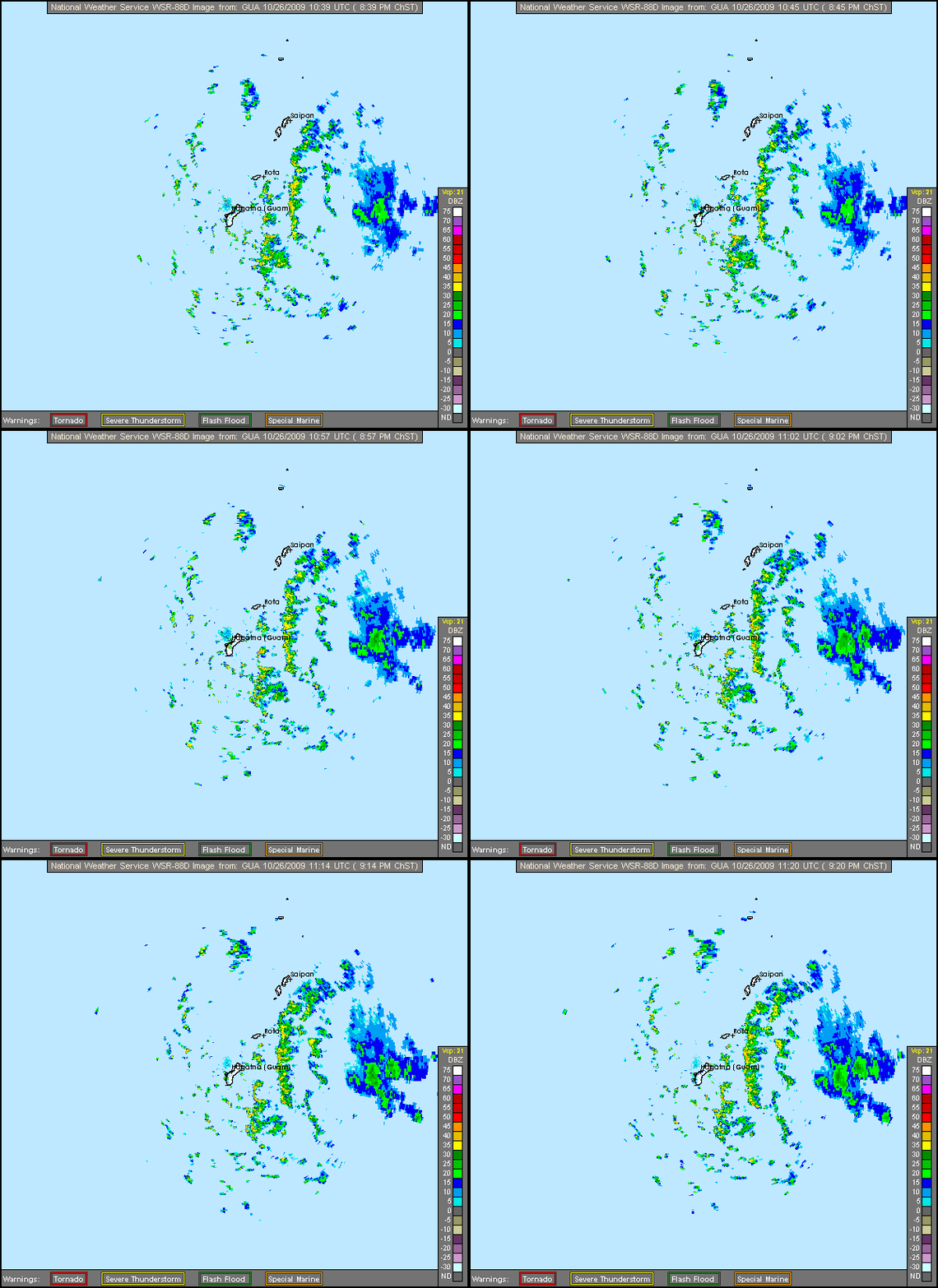
WPAC : TROPICAL DEPRESSION MIRINAE (23W)

Moderator: S2k Moderators

Message
Author
User avatar
ManilaTC
WesternPacificWeather.com
Posts: 593
Age: 47
Joined: Mon Oct 26, 2009 5:13 am
Location: Mandaluyong City, Philippines
Contact:

Re: WPAC : TROPICAL DEPRESSION 23W

#181 Postby ManilaTC » Mon Oct 26, 2009 6:03 am

dexterlabio wrote:Wow. I thought I'm the only one who can recall those two. The names Reming, Seniang and Xangxane (the int'l name) is already known by most of us to be related in 2006 typhoon season.

Hey, it's been 15 years since I had an encounter with a typhoon's eye. The trees outside were all shaking then the environment was at peace suddenly. I tried to look out my window to see if that is already the eye, because if not then maybe the typhoon weakened surprisingly. However, I saw the sky was almost clear, with some clouds on top, I just couldn't describe it any more better. That was the time that I had STY Rosing (Angela) eye to eye :wink:


How about an extended eyewall experience? Milenyo caught me on the road, going to work with all its blazing fury.
0 likes   
The above post is NOT official and should not be used as such. It is my opinion and may or may not be backed by sound meteorological data. It is not endorsed by any professional institution or storm2k.org. Please refer to your official national weather agency.

WEB http://goo.gl/JDiKXB | FB https://goo.gl/N5sIle | @ManilaTC

oaba09
S2K Supporter
S2K Supporter
Posts: 1496
Age: 38
Joined: Thu Oct 01, 2009 10:02 am
Location: Valenzuela, Philippines
Contact:

Re: WPAC : TROPICAL DEPRESSION 23W

#182 Postby oaba09 » Mon Oct 26, 2009 6:03 am

ClarkEligue wrote:
dexterlabio wrote:Wow. I thought I'm the only one who can recall those two. The names Reming, Seniang and Xangxane (the int'l name) is already known by most of us to be related in 2006 typhoon season.

Hey, it's been 15 years since I had an encounter with a typhoon's eye. The trees outside were all shaking then the environment was at peace suddenly. I tried to look out my window to see if that is already the eye, because if not then maybe the typhoon weakened surprisingly. However, I saw the sky was almost clear, with some clouds on top, I just couldn't describe it any more better. That was the time that I had STY Rosing (Angela) eye to eye :wink:


How about an extended eyewall experience? Milenyo caught me on the road, going to work with all its blazing fury.


Why did you go to work knowing that metro will get a direct hit?
0 likes   

User avatar
ManilaTC
WesternPacificWeather.com
Posts: 593
Age: 47
Joined: Mon Oct 26, 2009 5:13 am
Location: Mandaluyong City, Philippines
Contact:

Re: WPAC : TROPICAL DEPRESSION 23W

#183 Postby ManilaTC » Mon Oct 26, 2009 6:10 am

oaba09 wrote:
ClarkEligue wrote:
dexterlabio wrote:Wow. I thought I'm the only one who can recall those two. The names Reming, Seniang and Xangxane (the int'l name) is already known by most of us to be related in 2006 typhoon season.

Hey, it's been 15 years since I had an encounter with a typhoon's eye. The trees outside were all shaking then the environment was at peace suddenly. I tried to look out my window to see if that is already the eye, because if not then maybe the typhoon weakened surprisingly. However, I saw the sky was almost clear, with some clouds on top, I just couldn't describe it any more better. That was the time that I had STY Rosing (Angela) eye to eye :wink:


How about an extended eyewall experience? Milenyo caught me on the road, going to work with all its blazing fury.


Why did you go to work knowing that metro will get a direct hit?


I work in a BPO, and knowing the schedule adherence strictness.
I had to go to work.

I tried to get ahead of it, but got caught in the eyewall...
Although I was prepared to go out...
(My clothes were in a plastic bag, and I was only wearing shorts and sandals... )
I was expecting a battle, and it was a battle I got much like what the storm chasers experience in the US
when you view their videos

It was an experience I will never forget.
Last edited by ManilaTC on Mon Oct 26, 2009 6:12 am, edited 1 time in total.
0 likes   
The above post is NOT official and should not be used as such. It is my opinion and may or may not be backed by sound meteorological data. It is not endorsed by any professional institution or storm2k.org. Please refer to your official national weather agency.

WEB http://goo.gl/JDiKXB | FB https://goo.gl/N5sIle | @ManilaTC

dexterlabio
Category 5
Category 5
Posts: 3468
Joined: Sat Oct 24, 2009 11:50 pm

Re: WPAC : TROPICAL DEPRESSION 23W

#184 Postby dexterlabio » Mon Oct 26, 2009 6:11 am

ClarkEligue wrote:
dexterlabio wrote:Wow. I thought I'm the only one who can recall those two. The names Reming, Seniang and Xangxane (the int'l name) is already known by most of us to be related in 2006 typhoon season.

Hey, it's been 15 years since I had an encounter with a typhoon's eye. The trees outside were all shaking then the environment was at peace suddenly. I tried to look out my window to see if that is already the eye, because if not then maybe the typhoon weakened surprisingly. However, I saw the sky was almost clear, with some clouds on top, I just couldn't describe it any more better. That was the time that I had STY Rosing (Angela) eye to eye :wink:


How about an extended eyewall experience? Milenyo caught me on the road, going to work with all its blazing fury.


My eyewall experience with Rosing is like a nightmare. It feels like you're not comfortable with your home, like if it is going to endure the strong winds. I saw continuous gusts of wind with some rain in my window. No one dared to go out, and I think even one person would be taken away by its force. Milenyo was also intense, but not as intense as Rosing.
0 likes   
Personal Forecast Disclaimer:
The posts in this forum are NOT official forecast and should not be used as such. They are just the opinion of the poster and may or may not be backed by sound meteorological data. They are NOT endorsed by any professional institution or storm2k.org. For official information, please refer to the NHC and NWS products.

ricmood

Re: WPAC : TROPICAL DEPRESSION 23W

#185 Postby ricmood » Mon Oct 26, 2009 6:13 am

0 likes   

User avatar
HURAKAN
Professional-Met
Professional-Met
Posts: 46086
Age: 38
Joined: Thu May 20, 2004 4:34 pm
Location: Key West, FL
Contact:

Re: WPAC : TROPICAL DEPRESSION 23W

#186 Postby HURAKAN » Mon Oct 26, 2009 6:14 am

Image

WTPN32 PGTW 260900
MSGID/GENADMIN/NAVMARFCSTCEN PEARL HARBOR HI/JTWC//
SUBJ/TROPICAL CYCLONE WARNING//
RMKS/
1. TROPICAL DEPRESSION 23W (TWENTYTHREE) WARNING NR 002
02 ACTIVE TROPICAL CYCLONES IN NORTHWESTPAC
MAX SUSTAINED WINDS BASED ON ONE-MINUTE AVERAGE
WIND RADII VALID OVER OPEN WATER ONLY
---
WARNING POSITION:
260600Z --- NEAR 12.7N 149.9E
MOVEMENT PAST SIX HOURS - 290 DEGREES AT 15 KTS
POSITION ACCURATE TO WITHIN 060 NM
POSITION BASED ON CENTER LOCATED BY SATELLITE
PRESENT WIND DISTRIBUTION:
MAX SUSTAINED WINDS - 030 KT, GUSTS 040 KT
WIND RADII VALID OVER OPEN WATER ONLY
REPEAT POSIT: 12.7N 149.9E
---
FORECASTS:
12 HRS, VALID AT:
261800Z --- 13.4N 147.3E
MAX SUSTAINED WINDS - 035 KT, GUSTS 045 KT
WIND RADII VALID OVER OPEN WATER ONLY
VECTOR TO 24 HR POSIT: 285 DEG/ 14 KTS
---
24 HRS, VALID AT:
270600Z --- 14.1N 144.6E
MAX SUSTAINED WINDS - 045 KT, GUSTS 055 KT
WIND RADII VALID OVER OPEN WATER ONLY
RADIUS OF 034 KT WINDS - 050 NM NORTHEAST QUADRANT
045 NM SOUTHEAST QUADRANT
050 NM SOUTHWEST QUADRANT
055 NM NORTHWEST QUADRANT
VECTOR TO 36 HR POSIT: 280 DEG/ 14 KTS
---
36 HRS, VALID AT:
271800Z --- 14.5N 141.8E
MAX SUSTAINED WINDS - 055 KT, GUSTS 070 KT
WIND RADII VALID OVER OPEN WATER ONLY
RADIUS OF 050 KT WINDS - 025 NM NORTHEAST QUADRANT
025 NM SOUTHEAST QUADRANT
025 NM SOUTHWEST QUADRANT
025 NM NORTHWEST QUADRANT
RADIUS OF 034 KT WINDS - 080 NM NORTHEAST QUADRANT
070 NM SOUTHEAST QUADRANT
075 NM SOUTHWEST QUADRANT
085 NM NORTHWEST QUADRANT
VECTOR TO 48 HR POSIT: 275 DEG/ 14 KTS
---
EXTENDED OUTLOOK:
48 HRS, VALID AT:
280600Z --- 14.7N 138.9E
MAX SUSTAINED WINDS - 065 KT, GUSTS 080 KT
WIND RADII VALID OVER OPEN WATER ONLY
RADIUS OF 050 KT WINDS - 040 NM NORTHEAST QUADRANT
035 NM SOUTHEAST QUADRANT
035 NM SOUTHWEST QUADRANT
040 NM NORTHWEST QUADRANT
RADIUS OF 034 KT WINDS - 100 NM NORTHEAST QUADRANT
095 NM SOUTHEAST QUADRANT
095 NM SOUTHWEST QUADRANT
105 NM NORTHWEST QUADRANT
VECTOR TO 72 HR POSIT: 275 DEG/ 12 KTS
---
72 HRS, VALID AT:
290600Z --- 14.9N 133.8E
MAX SUSTAINED WINDS - 075 KT, GUSTS 090 KT
WIND RADII VALID OVER OPEN WATER ONLY
RADIUS OF 064 KT WINDS - 025 NM NORTHEAST QUADRANT
025 NM SOUTHEAST QUADRANT
025 NM SOUTHWEST QUADRANT
025 NM NORTHWEST QUADRANT
RADIUS OF 050 KT WINDS - 050 NM NORTHEAST QUADRANT
045 NM SOUTHEAST QUADRANT
045 NM SOUTHWEST QUADRANT
050 NM NORTHWEST QUADRANT
RADIUS OF 034 KT WINDS - 115 NM NORTHEAST QUADRANT
105 NM SOUTHEAST QUADRANT
110 NM SOUTHWEST QUADRANT
120 NM NORTHWEST QUADRANT
VECTOR TO 96 HR POSIT: 270 DEG/ 12 KTS
---
LONG RANGE OUTLOOK:
NOTE...ERRORS FOR TRACK HAVE AVERAGED NEAR 250 NM
ON DAY 4 AND 350 NM ON DAY 5... AND FOR INTENSITY
NEAR 20 KT EACH DAY.
---
96 HRS, VALID AT:
300600Z --- 14.8N 128.9E
MAX SUSTAINED WINDS - 090 KT, GUSTS 110 KT
WIND RADII VALID OVER OPEN WATER ONLY
VECTOR TO 120 HR POSIT: 265 DEG/ 12 KTS
---
120 HRS, VALID AT:
310600Z --- 14.4N 123.9E
MAX SUSTAINED WINDS - 100 KT, GUSTS 125 KT
WIND RADII VALID OVER OPEN WATER ONLY
---
REMARKS:
260900Z POSITION NEAR 12.9N 149.3E.
TROPICAL DEPRESSION (TD) 23W (TWENTYTHREE), LOCATED APPROXIMATELY 290
NM EAST OF GUAM, HAS TRACKED WEST-NORTHWESTWARD AT 15 KNOTS OVER THE
PAST SIX HOURS. ANIMATED MULTISPECTRAL IMAGERY SHOWS MULTIPLE BANDS
CONSOLIDATING TOWARDS A LOW LEVEL CIRCULATION CENTER THAT IS
DIFFICULT TO PINPOINT DUE TO OVERCAST DEEP CONVECTION. THE CURRENT
INTENSITY IS BASED ON DVORAK ESTIMATE FROM PGTW. UPPER LEVEL ANALYSIS
INDICATES THE SYSTEM IS JUST SOUTH OF THE SUBTROPICAL RIDGE AXIS IN
AN AREA OF LOW VERTICAL WIND SHEAR. ANIMATED WATER VAPOR IMAGERY
SHOWS A GOOD POLEWARD OUTFLOW ENHANCED BY THE TROPICAL UPPER
TROPOSPHERIC TROUGH TO THE NORTHEAST. TD 23W IS TRACKING ALONG THE
SOUTHERN PERIPHERY OF A LOW- TO MID-LEVEL SUBTROPICAL RIDGE TO THE
NORTH. IT IS EXPECTED TO CONTINUE ALONG THIS TRAJECTORY THROUGHOUT
THE FORECAST PERIOD AND GRADUALLY INTENSIFY, PEAKING AT THE EXTENDED
TAUS AS IT DRIFTS ACROSS THE WARMER WATERS OF THE PHILIPPINE SEA. THE
MINIMAL NUMERIC GUIDANCE THAT IS AVAILABLE SUPPORTS THIS TRACK
FORECAST WITH WBAR AS THE RIGHTMOST OUTLIER. EGRR IS LEFT OF THE PACK
FAVORING A MORE WESTWARD TRACK. THIS FORECAST IS LEFT OF CONSENSUS.
MAXIMUM SIGNIFICANT WAVE HEIGHT AT 260600Z IS 11 FEET. NEXT WARNINGS
AT 261500Z, 262100Z, 270300Z AND 270900Z.//
NNNN
0 likes   

User avatar
HURAKAN
Professional-Met
Professional-Met
Posts: 46086
Age: 38
Joined: Thu May 20, 2004 4:34 pm
Location: Key West, FL
Contact:

#187 Postby HURAKAN » Mon Oct 26, 2009 6:15 am

Image

Latest
0 likes   

User avatar
cycloneye
Admin
Admin
Posts: 145277
Age: 68
Joined: Thu Oct 10, 2002 10:54 am
Location: San Juan, Puerto Rico

Re: WPAC : TROPICAL DEPRESSION 23W

#188 Postby cycloneye » Mon Oct 26, 2009 6:16 am


Moving WNW,the projected path.
0 likes   
Visit the Caribbean-Central America Weather Thread where you can find at first post web cams,radars
and observations from Caribbean basin members Click Here

dexterlabio
Category 5
Category 5
Posts: 3468
Joined: Sat Oct 24, 2009 11:50 pm

Re: WPAC : TROPICAL DEPRESSION 23W

#189 Postby dexterlabio » Mon Oct 26, 2009 6:16 am

Okay, back with TD 23W. Latest sat images show that its circulation is somewhat concentrated on its north. If you look at the euro models, you will notice that this system's circulation is largely extended on the north. It seems to be like that for me. I dunno how to interpret these models in the first place, but the way they represented this system is huge in the extended forecasts. Does it mean that TD23W will also have a huge circulation?
0 likes   
Personal Forecast Disclaimer:
The posts in this forum are NOT official forecast and should not be used as such. They are just the opinion of the poster and may or may not be backed by sound meteorological data. They are NOT endorsed by any professional institution or storm2k.org. For official information, please refer to the NHC and NWS products.

User avatar
HURAKAN
Professional-Met
Professional-Met
Posts: 46086
Age: 38
Joined: Thu May 20, 2004 4:34 pm
Location: Key West, FL
Contact:

#190 Postby HURAKAN » Mon Oct 26, 2009 6:16 am

JMA

TROPICAL DEPRESSION 1002 HPA AT 13N 150E WNW 15 KT
0 likes   

dexterlabio
Category 5
Category 5
Posts: 3468
Joined: Sat Oct 24, 2009 11:50 pm

Re: WPAC : TROPICAL DEPRESSION 23W

#191 Postby dexterlabio » Mon Oct 26, 2009 6:18 am

cycloneye wrote:


Moving WNW,the projected path.


It moved WNW a while ago but for now, it seems to be tracking a bit westwards, still w/ a north forward motion.
0 likes   
Personal Forecast Disclaimer:
The posts in this forum are NOT official forecast and should not be used as such. They are just the opinion of the poster and may or may not be backed by sound meteorological data. They are NOT endorsed by any professional institution or storm2k.org. For official information, please refer to the NHC and NWS products.

User avatar
HURAKAN
Professional-Met
Professional-Met
Posts: 46086
Age: 38
Joined: Thu May 20, 2004 4:34 pm
Location: Key West, FL
Contact:

#192 Postby HURAKAN » Mon Oct 26, 2009 6:26 am

Image


000
WTPQ32 PGUM 260939
TCPPQ2

BULLETIN
TROPICAL DEPRESSION 23W ADVISORY NUMBER 2
NATIONAL WEATHER SERVICE TIYAN GU WP232009
800 PM CHST MON OCT 26 2009

...TROPICAL DEPRESSION 23W CONTINUES TOWARD THE MARIANAS...

A TROPICAL STORM WARNING IS NOW IN EFFECT FOR ROTA...TINIAN AND
SAIPAN.

A TROPICAL STORM WATCH REMAINS IN EFFECT FOR GUAM.

A TROPICAL STORM WARNING MEANS THAT TROPICAL-STORM FORCE WINDS OF 39
MPH OR HIGHER ARE EXPECTED IN THE NEXT 24 HOURS.

A TROPICAL STORM WATCH MEANS THAT TROPICAL-STORM FORCE WINDS OF 39
MPH OR HIGHER ARE POSSIBLE IN THE NEXT 24 HOURS.

AT 700 PM CHST...0900Z...THE CENTER OF TROPICAL DEPRESSION 23W WAS
LOCATED NEAR LATITUDE 12.0 DEGREES NORTH AND LONGITUDE 148.9 DEGREES
EAST.

THIS IS ABOUT 295 MILES EAST-SOUTHEAST OF GUAM AND
300 MILES SOUTHEAST OF SAIPAN.

TROPICAL DEPRESSION 23W IS MOVING WEST AT 17 MPH. THIS GENERAL
MOTION IS EXPECTED TO CONTINUE OVER THE NEXT 24 HOURS WITH A SLIGHT
TURN TO THE WEST-NORTHWEST. ON THE CURRENT FORECAST TRACK...TROPICAL
DEPRESSION 23W IS EXPECTED TO PASS BETWEEN GUAM AND ROTA ON TUESDAY
AFTERNOON.

MAXIMUM SUSTAINED WINDS ARE 35 MPH. TROPICAL DEPRESSION 23W IS
EXPECTED TO INTENSIFY AND MAY BECOME A TROPICAL STORM WITHIN THE
NEXT 12 HOURS.

REPEATING THE 700 PM CHST POSITION...12.0 DEGREES NORTH LATITUDE AND
148.9 DEGREES EAST LONGITUDE...MOVING WEST AT 17 MPH WITH MAXIMUM
SUSTAINED WINDS OF 35 MPH.

AN INTERMEDIATE ADVISORY WILL BE ISSUED BY THE NATIONAL WEATHER
SERVICE AT 11 PM CHST FOLLOWED BY THE NEXT SCHEDULED ADVISORY AT 2
AM CHST TUESDAY.

$$

STANKO/EDSON
0 likes   

User avatar
cycloneye
Admin
Admin
Posts: 145277
Age: 68
Joined: Thu Oct 10, 2002 10:54 am
Location: San Juan, Puerto Rico

Re: WPAC : TROPICAL DEPRESSION 23W

#193 Postby cycloneye » Mon Oct 26, 2009 6:28 am

0 likes   
Visit the Caribbean-Central America Weather Thread where you can find at first post web cams,radars
and observations from Caribbean basin members Click Here

User avatar
HURAKAN
Professional-Met
Professional-Met
Posts: 46086
Age: 38
Joined: Thu May 20, 2004 4:34 pm
Location: Key West, FL
Contact:

#194 Postby HURAKAN » Mon Oct 26, 2009 6:34 am

Image

Latest
0 likes   

oaba09
S2K Supporter
S2K Supporter
Posts: 1496
Age: 38
Joined: Thu Oct 01, 2009 10:02 am
Location: Valenzuela, Philippines
Contact:

#195 Postby oaba09 » Mon Oct 26, 2009 6:35 am

jtwc's forecast seems to be accurate so far......
0 likes   

dexterlabio
Category 5
Category 5
Posts: 3468
Joined: Sat Oct 24, 2009 11:50 pm

Re: WPAC : TROPICAL DEPRESSION 23W

#196 Postby dexterlabio » Mon Oct 26, 2009 6:54 am

i'll be coming back tomorrow night or wednesday. haha. as of now, the forecast is becoming consistent. still, there might be some changes as the days go by...
0 likes   
Personal Forecast Disclaimer:
The posts in this forum are NOT official forecast and should not be used as such. They are just the opinion of the poster and may or may not be backed by sound meteorological data. They are NOT endorsed by any professional institution or storm2k.org. For official information, please refer to the NHC and NWS products.

User avatar
ManilaTC
WesternPacificWeather.com
Posts: 593
Age: 47
Joined: Mon Oct 26, 2009 5:13 am
Location: Mandaluyong City, Philippines
Contact:

Re: WPAC : TROPICAL DEPRESSION 23W

#197 Postby ManilaTC » Mon Oct 26, 2009 7:12 am

Will keep tabs on this storm.

Once the JMA takes 23W as a TS, forecast tracks will then show up from all the agencies.
I usually make my own tracks from them :D

Will post em here.

This could be a big one, as the Philippine Sea is conducive for Rapid Intensification.

A candidate for the 5th Super Typhoon of the year after Choi-wan, Parma(Pepeng), Melor(Quedan) and Lupit(Ramil).
0 likes   
The above post is NOT official and should not be used as such. It is my opinion and may or may not be backed by sound meteorological data. It is not endorsed by any professional institution or storm2k.org. Please refer to your official national weather agency.

WEB http://goo.gl/JDiKXB | FB https://goo.gl/N5sIle | @ManilaTC

User avatar
drdavisjr
Category 1
Category 1
Posts: 428
Age: 57
Joined: Mon Oct 12, 2009 7:07 am
Location: Marilao, Bulacan, Philippines
Contact:

Re:

#198 Postby drdavisjr » Mon Oct 26, 2009 7:26 am

oaba09 wrote:jtwc's forecast seems to be accurate so far......


after all the craziness with the tracks of parma and lupit, there is bound to be a storm that follows the forecast.

scary huh...
0 likes   

User avatar
cycloneye
Admin
Admin
Posts: 145277
Age: 68
Joined: Thu Oct 10, 2002 10:54 am
Location: San Juan, Puerto Rico

Re: WPAC : TROPICAL DEPRESSION 23W

#199 Postby cycloneye » Mon Oct 26, 2009 7:32 am

000
WTPQ82 PGUM 261136
HLSPQ2

URGENT - IMMEDIATE BROADCAST REQUESTED
TROPICAL DEPRESSION 23W LOCAL STATEMENT
NATIONAL WEATHER SERVICE TIYAN GU
936 PM CHST MON OCT 26 2009

...TROPICAL DEPRESSION 23W CONTINUES TOWARD THE MARIANAS...

.AREAS AFFECTED...
THIS LOCAL STATEMENT PROVIDES INFORMATION AND RECOMMENDED ACTIONS
FOR PEOPLE AND MARINE INTERESTS IN THE MARIANAS AND SURROUNDING
WATERS OUT TO 40 NM.

.WATCHES/WARNINGS...
A TROPICAL STORM WARNING IS IN EFFECT FOR ROTA...TINIAN AND
SAIPAN AND SURROUNDING WATERS OUT TO 40 NM.

A TROPICAL STORM WATCH CONTINUES FOR GUAM AND SURROUNDING WATERS
OUT TO 40 NM.

.STORM INFORMATION...
AT 7 PM CHST...THE CENTER OF TROPICAL DEPRESSION 23W WAS LOCATED
NEAR 12.0 DEGREES NORTH LATITUDE AND 148.9 DEGREES EAST LONGITUDE.
TROPICAL DEPRESSION 23W WAS MOVING WEST AT 17 MPH AND HAD MAXIMUM
SUSTAINED WINDS OF 35 MPH.

.SITUATION OVERVIEW...
TROPICAL DEPRESSION 23W CONTINUES TO APPROACH THE MARIANAS.
TROPICAL STORM FORCE DAMAGING WINDS AND HEAVY RAINS ARE EXPECTED TO
ACCOMPANY 23W AS IT INTENSIFIES INTO A STORM.

.PRECAUTIONARY/PREPAREDNESS ACTIONS...
FOR THOSE UNDER A WARNING...NOW IS THE TIME TO RUSH TO COMPLETION
PREPARATIONS FOR THE PROTECTION OF LIFE AND PROPERTY. PEOPLE AT
PORTS...DOCKS...AND MARINAS...URGENTLY COMPLETE PRESCRIBED
PREPARATIONS ACCORDING TO YOUR EMERGENCY OPERATIONS PLAN FOR
TROPICAL CYCLONES. IF YOU LIVE ON A BOAT...MAKE FINAL PREPARATIONS
FOR SECURING YOUR CRAFT. FOR THOSE UNDER A WATCH...CONTINUE WITH
YOUR PREPARATIONS AND LISTEN FOR POSSIBLE WARNINGS. REGARDING ANY
COASTAL WATERS UNDER A WATCH...SMALL CRAFT SHOULD RETURN TO PORT
OR SEEK SAFE HARBOR. DETERMINE THE BEST STRATEGY FOR SECURING YOUR
CRAFT. CLOSELY MONITOR NOAA WEATHER RADIO OR OTHER LOCAL NEWS
OUTLETS FOR OFFICIAL STORM INFORMATION. LISTEN FOR POSSIBLE
CHANGES TO THE FORECAST. FOR ADDITIONAL PRECAUTIONARY AND
PREPAREDNESS INFORMATION... PLEASE REFER TO THE DETAILED
RECOMMENDATIONS RELATIVE TO YOUR LOCATION AS FURTHER DESCRIBED BY
YOUR LOCAL NATIONAL WEATHER SERVICE OFFICE AND LOCAL EMERGENCY
MANAGEMENT.

&&

.NEXT UPDATE...
THE NEXT LOCAL STATEMENT WILL BE ISSUED BY THE NATIONAL WEATHER
SERVICE IN TIYAN AROUND 3 AM CHST TUESDAY...OR SOONER IF
CONDITIONS WARRANT.

GUZ001-PMZ151-271145-
/X.CON.PGUM.TR.A.0005.000000T0000Z-000000T0000Z/
GUAM-GUAM COASTAL WATERS-
936 PM CHST MON OCT 26 2009

...TROPICAL STORM WATCH REMAINS IN EFFECT...

...PRECAUTIONARY/PREPAREDNESS ACTIONS...
STAY INFORMED AND LISTEN FOR POSSIBLE CHANGES TO THE FORECAST.
PREPARATIONS FOR THIS STORM SHOULD BE MADE AS SOON AS POSSIBLE.

&&

...WINDS...
TROPICAL STORM FORCE WINDS OF AROUND 40 MPH ARE POSSIBLE TUESDAY
AND TUESDAY EVENING AS 23W MOVES THROUGH THE MARIANAS. NORTHWEST
WINDS TUESDAY SHOULD BACK TOWARD THE SOUTH BY TUESDAY NIGHT.

...STORM SURGE AND STORM TIDE...
A STORM SURGE OF ABOUT ONE FOOT ABOVE HIGH TIDE IS POSSIBLE. SURF
WILL BE HAZARDOUS ON WINDWARD EXPOSURES.

...OTHER STORM EFFECTS...
LOCALLY HEAVY RAINFALL OF 1 TO 3 INCHES IS POSSIBLE THROUGH
TUESDAY NIGHT.

$$

GUZ002-PMZ152-271145-
/X.UPG.PGUM.TR.A.0005.000000T0000Z-000000T0000Z/
/X.NEW.PGUM.TR.W.0004.091026T1136Z-000000T0000Z/
ROTA-ROTA COASTAL WATERS-
936 PM CHST MON OCT 26 2009

...TROPICAL STORM WARNING IN EFFECT...

...PRECAUTIONARY/PREPAREDNESS ACTIONS...
FINAL PREPARATIONS TO PROTECT LIFE AND PROPERTY SHOULD BE
COMPLETED BEFORE CONDITIONS DETERIORATE. THE ONSET OF GUSTY WINDS
AND HEAVY RAINS CAN CAUSE OUTSIDE ACTIVITIES TO BECOME DANGEROUS.
SECURE LOOSE OUTDOOR OBJECTS WHICH CAN BE BLOWN AROUND. IF YOU
LIVE IN A TIN-ROOF HOME...LEAVE IT FOR MORE SUBSTANTIAL SHELTER.
BOAT OWNERS AND CAPTAINS OF SMALL CRAFT SHOULD RUSH TO COMPLETION
THE SECURING OF THEIR CRAFT.

&&

...WINDS...
TROPICAL STORM FORCE WINDS OF 45 TO 50 MPH OR MORE ARE POSSIBLE
EARLY TUESDAY AFTERNOON WITH TROPICAL FORCE WINDS REMAINING
INTO TUESDAY EVENING AS 23W MOVES THROUGH THE AREA. NORTH WINDS
TUESDAY SHOULD VEER TO THE SOUTH BY TUESDAY NIGHT.

...STORM SURGE AND STORM TIDE...
A STORM SURGE OF ABOUT ONE TO TWO FEET ABOVE HIGH TIDE IS
POSSIBLE. SURF WILL BE HAZARDOUS ON WINDWARD EXPOSURES.

...OTHER STORM EFFECTS...
LOCALLY HEAVY RAINFALL OF 3 TO 6 INCHES IS POSSIBLE THROUGH
TUESDAY NIGHT.

$$

GUZ003-004-PMZ153-154-271145-
/X.UPG.PGUM.TR.A.0005.000000T0000Z-000000T0000Z/
/X.NEW.PGUM.TR.W.0004.091026T1136Z-000000T0000Z/
TINIAN-SAIPAN-TINIAN COASTAL WATERS-SAIPAN COASTAL WATERS-
936 PM CHST MON OCT 26 2009

...TROPICAL STORM WARNING IN EFFECT...

...PRECAUTIONARY/PREPAREDNESS ACTIONS...
FINAL PREPARATIONS TO PROTECT LIFE AND PROPERTY SHOULD BE
COMPLETED BEFORE CONDITIONS DETERIORATE. THE ONSET OF GUSTY WINDS
AND HEAVY RAINS CAN CAUSE OUTSIDE ACTIVITIES TO BECOME DANGEROUS.
SECURE LOOSE OUTDOOR OBJECTS WHICH CAN BE BLOWN AROUND. IF YOU
LIVE IN A TIN-ROOF HOME...LEAVE IT FOR MORE SUBSTANTIAL SHELTER.
BOAT OWNERS AND CAPTAINS OF SMALL CRAFT SHOULD RUSH TO COMPLETION
THE SECURING OF THEIR CRAFT.

&&

...WINDS...
TROPICAL STORM FORCE WINDS OF 35 TO 40 MPH OR MORE ARE POSSIBLE
TUESDAY BEFORE NOON THROUGH TUESDAY EVENING AS 23W MOVES THROUGH
THE MARIANAS. EAST WINDS WILL PERSIST THROUGH TUESDAY WITH LITTLE
CHANGE IN DIRECTION BEFORE DECREASING BELOW TROPICAL STORM FORCE
WINDS AFTER MIDNIGHT.

...STORM SURGE AND STORM TIDE...
A STORM SURGE OF ABOUT ONE TO TWO FEET ABOVE HIGH TIDE IS POSSIBLE.
SURF WILL BE HAZARDOUS ON WINDWARD EXPOSURES.

...OTHER STORM EFFECTS...
LOCALLY HEAVY RAINFALL OF 2 TO 5 INCHES IS POSSIBLE THROUGH
TUESDAY NIGHT.

0 likes   
Visit the Caribbean-Central America Weather Thread where you can find at first post web cams,radars
and observations from Caribbean basin members Click Here

User avatar
JTE50
Category 1
Category 1
Posts: 336
Age: 67
Joined: Mon Jul 21, 2008 10:48 am
Location: Pensacola
Contact:

Re: WPAC : TROPICAL DEPRESSION 23W

#200 Postby JTE50 » Mon Oct 26, 2009 7:39 am

We are getting heavy rains from TD23 now. I went out to pick up a pizza and you could tell this wasn't the usual passing shower. Some street flooding already. I thought I was getting a cold from the Lupit adventure in the Philippines but TD23 has me all fired up. I'll be good to go filming tomorrow.
0 likes   


Return to “2009”

Who is online

Users browsing this forum: No registered users and 0 guests