SPC has us under a Slight Risk as well...

DAY 3 CONVECTIVE OUTLOOK
NWS STORM PREDICTION CENTER NORMAN OK
0214 AM CDT TUE OCT 27 2009
VALID 291200Z - 301200Z
...THERE IS A SLGT RISK OF SVR TSTMS FROM CNTRL TX TO SRN MO...
...CNTRL TX...NEWD TO SRN MO...
UPPER TROUGH OVER THE SRN/CNTRL ROCKIES IS EXPECTED TO SHIFT EAST
INTO THE PLAINS DURING THE DAY3 PERIOD...THOUGH NOT AS A UNIFIED
LONG WAVE TROUGH BUT RATHER IN SEVERAL PIECES. ONE
SIGNIFICANT...AND LIKELY PRIMARY...UPPER CIRCULATION CENTER WILL
EJECT NEWD ACROSS CO INTO SD WITH SOME VARIANCE NOTED AMONG THE
LATEST SHORT RANGE MODEL GUIDANCE. A SECONDARY PIECE OF ENERGY WILL
EMERGE OVER FAR WEST TX LATE WITHIN THE BASE OF THE LONGER WAVE.
THIS SECONDARY SHORTWAVE WILL TRY TO INDUCE A WAVE ALONG SRN
PORTIONS OF THE COLD FRONT...MOST LIKELY ALONG THE LOWER RIO GRANDE
VALLEY BEFORE SHIFTING OFFSHORE. GIVEN THE BI-MODAL STRUCTURE OF
THIS EJECTING SYSTEM THERE ARE SOME NUANCES THAT WILL BE IMPOSSIBLE
TO ASCERTAIN THREE DAYS IN ADVANCE...NAMELY CONVECTIVE INFLUENCES
FROM DAY2 ACTIVITY AND ULTIMATE STORM MODE. OF PARTICULAR CONCERN
IS THE OVERALL MOISTURE INCREASE EXPECTED AHEAD OF COLD FRONT.
MODELS ARE IN GENERAL AGREEMENT THAT A LARGE SWATH OF 60+ SFC DEW
POINTS...70+ ACROSS PARTS OF TX/LA...WILL BE OBSERVED ACROSS THE
WARM SECTOR WHERE STRONGER H5 FLOW WILL OVERSPREAD A
MARGINAL-MODESTLY UNSTABLE AIRMASS. GIVEN THAT DEEP LAYER SHEAR IS
FORECAST TO BE STRONG...ANY STORMS THAT MANAGE TO DEVELOP EITHER
ALONG THE COLD FRONT...OR PERHAPS IMMEDIATELY AHEAD OF WIND
SHIFT...COULD PRODUCE SEVERE DAMAGING WIND GUSTS OR PERHAPS EVEN
ISOLATED TORNADOES. NWD EXTENT OF SEVERE RISK WILL BE LIMITED BY
MOISTURE RETURN NEEDED FOR SFC-BASED BUOYANCY.
..DARROW.. 10/27/2009
Morning e-mail from Jeff...
Small break before area is under the gun again Wed PM-Fri
Upper storm system from yesterday is clearing the area this morning with gusty NW winds and low clouds left behind. Clouds should erode quickly this morning leaving sunny skies and pleasant conditions. It will be very short lived as big changes return on Wed.
Powerful upper trough develops over the 4 corners over the next 24 hours resulting in impressive surface low pressure formation over the plains. Strong jet stream dynamics develop over TX with 40-50kt low level jet developing Wed afternoon below a nearly 140kt southern branch jet arching out of the SW US. Tremendous wind energy will come to bear over the state and this system…in addition to excessive rainfall looks to have a fairly high severe weather threat as well.
Moisture will make a rapid return Wed PM as the low level jet cranks up over the W Gulf. PWS near .4-.6 inches this morning rebound toward another 2.0 inch event by late Wed. Given aggressive moisture return Wed PM we will not be able to keep convection in check as lift begins to overspread the region from the approaching upper trough and very favorable upper air dynamics. Expect to see scattered thunderstorms develop by Wed late afternoon/evening and move inland off the western Gulf within low level warm air advection regime. This will continue all day Thursday with rounds of thunderstorms moving inland within the warm sector. Given low level wind shear profiles expected to be in place Thursday across the warm sector some of these cells may develop supercell structures and low level mesocyclones resulting in tornado formation.
Cold front slams into this very moist warm sector Thursday night with another slow moving squall line episode likely. GFS continues to slow this boundary over the area and produces some concerning rainfall amounts Thursday night/Friday morning. Pattern supports the slowing of the boundary and cell training in a near saturated air mass. Threat for excessive flooding rainfall will be high and with grounds now completely saturated significant run-off will be generated into already swollen and flooding creeks and rivers.
May see the boundary slip off the coast early Friday morning as convective outflows move it Gulfward. Upper trough lags back to the west with moisture being pulled up and over the cool dome at the surface with rain continuing into at least midday Friday and possibly Friday evening under increasing cold air advection at the surface.
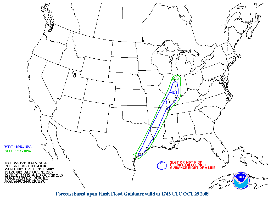
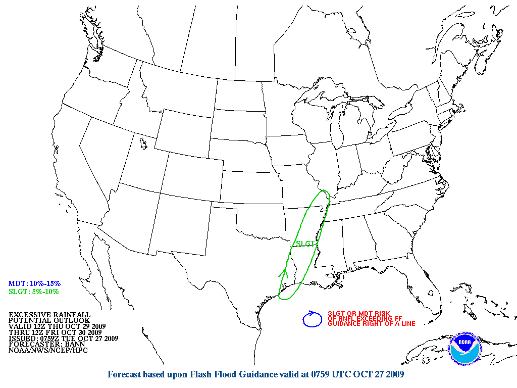
Flash Flood Watch will likely be issued Wed or early Thursday for this next event. Widespread 1-3 inches is likely with isolated amounts of 4-6 inches. Would not be surprised if a few 8 inch amounts occurred given the longer duration of the event and tremendous moisture in place. All severe modes will be possible with this system also given the strong wind energy that will be in place. Tornado threat will be increasing across the returning warm sector Wed PM into Thursday with hail/wind threat along the squall line Thursday night/Friday morning.
Hydro:
Rainfall yesterday on top of downstream moving flood waves is resulting in additional rises on area rivers bringing them closer to flood stage. Upstream flood gate operations on the Brazos and Trinity basins will result in downstream rises along with non-flood control lakes passing through the run-off from the rains of the past several weeks.
Trinity River:
Minor flooding is in progress both above and below Lake Livingston as upstream run-off moves downstream. Operations at Lake Livingston will send more water downstream toward Liberty toward the end of the week with minor to moderate flooding to continue.
Brazos River:
Inflows from the Navasota River and Little River will result in rises on the middle and lower Brazos basin this week. While rises are expected the river is forecast to remain below flood stage at all forecast points.
Navasota River:
The river is rising and will rise to near flood stage late this week into this weekend and hold.
Tres Palacios River:
River is near flood stage this morning, but should crest and begin to fall today.
Lavaca/Navidad Rivers:
Rises are in progress on these rivers, but should remain below flood stage
Colorado River:
Upstream heavy rains above the Highland Lakes should be contained into the flood control pool at Lake Travis. Run-off below Lake Travis will result in a rise on the lower Colorado River, but the river should remain below flood stage.
Guadalupe River:
Rises on the middle part of the basin will translate downstream. Bloomington is already above flood stage and is forecast to fall and then rise back above flood stage toward the end of the week. The forecast at Victoria is are a rise to above action stage, but not flood stage toward the end of the week, but there is a good amount of water coming downstream and given the QPF for the end of the week flooding on the lower Guadalupe River looks likely.
Rainfall Thursday-Friday will be widespread with high basin wide averages leading to additional run-off and likely additional river increases.


 my Cowboys