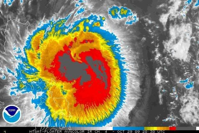
WPAC : TROPICAL DEPRESSION MIRINAE (23W)

Moderator: S2k Moderators

Message
Author
User avatar
breeze
Category 5
Category 5
Posts: 9110
Age: 62
Joined: Sat Feb 08, 2003 4:55 pm
Location: Lawrenceburg, TN

Re: WPAC : TYPHOON MIRINAE (23W)=Metro Manila under Signal 2

#1141 Postby breeze » Thu Oct 29, 2009 5:04 pm

dexterlabio wrote:
cebuboy wrote:
dexterlabio wrote:i woke up this morning to prepare for school, then i heard in the radio that it is signal#2 here in metro manila. wow. mirinae is becoming closer... and larger, seeing the latest satellite image of mirinae, it has very large amount of rainfall. looks like we have to get ready for both the rains and winds O_O scary as halloween...

Classes are not suspended, work will continue, people seems not prepared. :(


yeah. i think the hype is on the coming halloween, and not on the coming howler O_O i am watching the local news and they are featuring halloween stuff, not about the storm. i wonder if the people are aware that this typhoon exists and is threatening their place.


That's so unfortunate - I was hoping the warnings would be all over the news by now!
0 likes   

ozonepete
Professional-Met
Professional-Met
Posts: 4743
Joined: Mon Sep 07, 2009 3:23 pm
Location: From Ozone Park, NYC / Now in Brooklyn, NY

Re: WPAC : TYPHOON MIRINAE (23W)=Metro Manila under Signal 2

#1142 Postby ozonepete » Thu Oct 29, 2009 5:05 pm

cebuboy wrote:Just sad to know, after our nation suffers a lot of typhoon casualties this year and is still looks acceptable. It is not normal to me.


Yes. I would be very nervous but cautious and careful and level-headed at this point.
0 likes   

oaba09
S2K Supporter
S2K Supporter
Posts: 1496
Age: 38
Joined: Thu Oct 01, 2009 10:02 am
Location: Valenzuela, Philippines
Contact:

#1143 Postby oaba09 » Thu Oct 29, 2009 5:11 pm

It was just on the news................signal #2 means there are no classes for the high school and grade school level....signal #3 means that there are no classes up to the college level.............currently polilio island is at signal #3 while metro manila is at signal #2
0 likes   

dexterlabio
Category 5
Category 5
Posts: 3468
Joined: Sat Oct 24, 2009 11:50 pm

Re: WPAC : TYPHOON MIRINAE (23W)=Metro Manila under Signal #2

#1144 Postby dexterlabio » Thu Oct 29, 2009 5:12 pm

just wanted to share this. i asked my neighbors on their plans for the all saint's day, and they said that they will visit the cemetery tomorrow and come back sunday night. after hearing that, i realized that people are not informed still about the coming storm.
0 likes   
Personal Forecast Disclaimer:
The posts in this forum are NOT official forecast and should not be used as such. They are just the opinion of the poster and may or may not be backed by sound meteorological data. They are NOT endorsed by any professional institution or storm2k.org. For official information, please refer to the NHC and NWS products.

ozonepete
Professional-Met
Professional-Met
Posts: 4743
Joined: Mon Sep 07, 2009 3:23 pm
Location: From Ozone Park, NYC / Now in Brooklyn, NY

Re: Re:

#1145 Postby ozonepete » Thu Oct 29, 2009 5:13 pm

dexterlabio wrote:
HURAKAN wrote:Image

Wow, look at the outflow


what does that indicate? i thought it already reached its peak winds, but the latest observations is that the typhoon's outflow is "improving" with huge convection, but i am not sure if it will intensify still.


I doubt it can get much stronger at all. The center of strongest thunderstorms is still not symmetrical (circular) enough at all, and the eye just can't seem to form. It is beginning to interact with land as well, and that will disrupt it further. It should come ashore as a bordeline cat 1/ cat 2 at about 80-90 knots and cross Manila as a cat 1, roughly. My best guess.

Image

The posts in this forum are NOT official forecast and should not be used as such. They are just the opinion of the poster and may or may not be backed by sound meteorological data. They are NOT endorsed by any professional institution or storm2k.org. For official information, please refer to the NHC and NWS products.
0 likes   

cebuboy
Tropical Depression
Tropical Depression
Posts: 94
Joined: Wed Sep 30, 2009 5:29 am
Location: Cebu, Philippines

Re: WPAC : TYPHOON MIRINAE (23W)=Metro Manila under Signal 2

#1146 Postby cebuboy » Thu Oct 29, 2009 5:14 pm

ozonepete wrote:
cebuboy wrote:Just sad to know, after our nation suffers a lot of typhoon casualties this year and is still looks acceptable. It is not normal to me.


Yes. I would be very nervous but cautious and careful and level-headed at this point.

Just see the news. Looks like only relief goods are being prepared, not the safety of the people. Makati buildings are tall, people in slum and near rivers should evacuate to Makati business district and occupy building. Sounds so crazy government action but it saves peoples lives. I also see schools are being used as evacuation areas here and is also flooded and can be flooded again.
0 likes   

neil40
Tropical Low
Tropical Low
Posts: 17
Joined: Thu Oct 29, 2009 4:59 pm

Re: WPAC : TYPHOON MIRINAE (23W)=Metro Manila under Signal #2

#1147 Postby neil40 » Thu Oct 29, 2009 5:25 pm

Good Morning...I'm new here...

Since the wrath of Ketsana, I became more interested in the latest weather forecast for the Philippines. Most of the time when visit the websites of TSR or Hurricane zone, it will give me the chills whenever I see a low pressure area forming in the Western North Pacific area and moving westward. S2k really helped me a lot to partially accept the reality that the Philippines is always, or most of the time, at the frontline of typhoons from WNPAC area.

I hope the present system that is about to enter Luzon will weaken to minimize the damage on our country. We're still expecting around 3-4 storms/typhoons before the year ends.

To the Storm Chasers, be safe. God bless us all
0 likes   

oaba09
S2K Supporter
S2K Supporter
Posts: 1496
Age: 38
Joined: Thu Oct 01, 2009 10:02 am
Location: Valenzuela, Philippines
Contact:

#1148 Postby oaba09 » Thu Oct 29, 2009 5:25 pm

Still moving WSW at this moment.........
0 likes   

dexterlabio
Category 5
Category 5
Posts: 3468
Joined: Sat Oct 24, 2009 11:50 pm

Re: Re:

#1149 Postby dexterlabio » Thu Oct 29, 2009 5:32 pm

ozonepete wrote:
dexterlabio wrote:
HURAKAN wrote:Image

Wow, look at the outflow


what does that indicate? i thought it already reached its peak winds, but the latest observations is that the typhoon's outflow is "improving" with huge convection, but i am not sure if it will intensify still.


I doubt it can get much stronger at all. The center of strongest thunderstorms is still not symmetrical (circular) enough at all, and the eye just can't seem to form. It is beginning to interact with land as well, and that will disrupt it further. It should come ashore as a bordeline cat 1/ cat 2 at about 80-90 knots and cross Manila as a cat 1, roughly. My best guess.

Image

The posts in this forum are NOT official forecast and should not be used as such. They are just the opinion of the poster and may or may not be backed by sound meteorological data. They are NOT endorsed by any professional institution or storm2k.org. For official information, please refer to the NHC and NWS products.


i hope so. even a mere tropical depression is enough for us here in metro manila. some areas are still submerged in water after ketsana dumped enormous amounts of rainfall. stronger winds will be another burden for us.
0 likes   
Personal Forecast Disclaimer:
The posts in this forum are NOT official forecast and should not be used as such. They are just the opinion of the poster and may or may not be backed by sound meteorological data. They are NOT endorsed by any professional institution or storm2k.org. For official information, please refer to the NHC and NWS products.

oaba09
S2K Supporter
S2K Supporter
Posts: 1496
Age: 38
Joined: Thu Oct 01, 2009 10:02 am
Location: Valenzuela, Philippines
Contact:

#1150 Postby oaba09 » Thu Oct 29, 2009 5:33 pm

It seems to be losing some of it's convection........
0 likes   

User avatar
breeze
Category 5
Category 5
Posts: 9110
Age: 62
Joined: Sat Feb 08, 2003 4:55 pm
Location: Lawrenceburg, TN

Re: WPAC : TYPHOON MIRINAE (23W)=Metro Manila under Signal #2

#1151 Postby breeze » Thu Oct 29, 2009 5:34 pm

neil40 wrote:Good Morning...I'm new here...

Since the wrath of Ketsana, I became more interested in the latest weather forecast for the Philippines. Most of the time when visit the websites of TSR or Hurricane zone, it will give me the chills whenever I see a low pressure area forming in the Western North Pacific area and moving westward. S2k really helped me a lot to partially accept the reality that the Philippines is always, or most of the time, at the frontline of typhoons from WNPAC area.

I hope the present system that is about to enter Luzon will weaken to minimize the damage on our country. We're still expecting around 3-4 storms/typhoons before the year ends.

To the Storm Chasers, be safe. God bless us all


I welcome you to Storm2K, neil40.
0 likes   

ozonepete
Professional-Met
Professional-Met
Posts: 4743
Joined: Mon Sep 07, 2009 3:23 pm
Location: From Ozone Park, NYC / Now in Brooklyn, NY

Re: WPAC : TYPHOON MIRINAE (23W)=Metro Manila under Signal #2

#1152 Postby ozonepete » Thu Oct 29, 2009 5:41 pm

neil40 wrote:Good Morning...I'm new here...

Since the wrath of Ketsana, I became more interested in the latest weather forecast for the Philippines. Most of the time when visit the websites of TSR or Hurricane zone, it will give me the chills whenever I see a low pressure area forming in the Western North Pacific area and moving westward. S2k really helped me a lot to partially accept the reality that the Philippines is always, or most of the time, at the frontline of typhoons from WNPAC area.

I hope the present system that is about to enter Luzon will weaken to minimize the damage on our country. We're still expecting around 3-4 storms/typhoons before the year ends.

To the Storm Chasers, be safe. God bless us all


Welcome! :)
0 likes   

dexterlabio
Category 5
Category 5
Posts: 3468
Joined: Sat Oct 24, 2009 11:50 pm

Re: WPAC : TYPHOON MIRINAE (23W)=Metro Manila under Signal #2

#1153 Postby dexterlabio » Thu Oct 29, 2009 5:42 pm

neil40 wrote:Good Morning...I'm new here...

Since the wrath of Ketsana, I became more interested in the latest weather forecast for the Philippines. Most of the time when visit the websites of TSR or Hurricane zone, it will give me the chills whenever I see a low pressure area forming in the Western North Pacific area and moving westward. S2k really helped me a lot to partially accept the reality that the Philippines is always, or most of the time, at the frontline of typhoons from WNPAC area.

I hope the present system that is about to enter Luzon will weaken to minimize the damage on our country. We're still expecting around 3-4 storms/typhoons before the year ends.

To the Storm Chasers, be safe. God bless us all


hello :) i am also a newbie here. i assure you, there are many things to learn from these awesome guys around here.
0 likes   
Personal Forecast Disclaimer:
The posts in this forum are NOT official forecast and should not be used as such. They are just the opinion of the poster and may or may not be backed by sound meteorological data. They are NOT endorsed by any professional institution or storm2k.org. For official information, please refer to the NHC and NWS products.

neil40
Tropical Low
Tropical Low
Posts: 17
Joined: Thu Oct 29, 2009 4:59 pm

#1154 Postby neil40 » Thu Oct 29, 2009 5:45 pm

Thanks, Breeze!

I have one question, this may sound very elementary but I have not heard a single crack or rumble of Thunder for quite sometime now... Is there any explanation on this?
0 likes   

User avatar
breeze
Category 5
Category 5
Posts: 9110
Age: 62
Joined: Sat Feb 08, 2003 4:55 pm
Location: Lawrenceburg, TN

Re:

#1155 Postby breeze » Thu Oct 29, 2009 5:47 pm

neil40 wrote:Thanks, Breeze!

I have one question, this may sound very elementary but I have not heard a single crack or rumble of Thunder for quite sometime now... Is there any explanation on this?


I'm going to let ozonepete answer that....:wink:
0 likes   

User avatar
cycloneye
Admin
Admin
Posts: 145309
Age: 68
Joined: Thu Oct 10, 2002 10:54 am
Location: San Juan, Puerto Rico

Re: WPAC : TYPHOON MIRINAE (23W)=Metro Manila under Signal #2

#1156 Postby cycloneye » Thu Oct 29, 2009 5:48 pm

Are there any radars in the Phillippines that we can see how the rainbands are closing in on SouthCentral Luzon?
0 likes   
Visit the Caribbean-Central America Weather Thread where you can find at first post web cams,radars
and observations from Caribbean basin members Click Here

neil40
Tropical Low
Tropical Low
Posts: 17
Joined: Thu Oct 29, 2009 4:59 pm

#1157 Postby neil40 » Thu Oct 29, 2009 5:49 pm

Thanks, dexterlabio!

Yup,I know this site will be a source of interesting facts about the changing weather patterns globally
0 likes   

Derek Ortt

#1158 Postby Derek Ortt » Thu Oct 29, 2009 5:53 pm

you get nice weather surrounding a TC due to subsiding air
0 likes   

neil40
Tropical Low
Tropical Low
Posts: 17
Joined: Thu Oct 29, 2009 4:59 pm

#1159 Postby neil40 » Thu Oct 29, 2009 5:56 pm

Thanks, ozonpete!

I hope you can help me with the very elementary question I asked breeze earlier. :D
0 likes   

dexterlabio
Category 5
Category 5
Posts: 3468
Joined: Sat Oct 24, 2009 11:50 pm

Re: WPAC : TYPHOON MIRINAE (23W)=Metro Manila under Signal #2

#1160 Postby dexterlabio » Thu Oct 29, 2009 5:59 pm

cycloneye wrote:Are there any radars in the Phillippines that we can see how the rainbands are closing in on SouthCentral Luzon?


i'm not sure, but PAGASA has this feature of showing the latest images of the storm. try going to http://www.pagasa.dost.gov.ph
Last edited by dexterlabio on Thu Oct 29, 2009 6:00 pm, edited 1 time in total.
0 likes   
Personal Forecast Disclaimer:
The posts in this forum are NOT official forecast and should not be used as such. They are just the opinion of the poster and may or may not be backed by sound meteorological data. They are NOT endorsed by any professional institution or storm2k.org. For official information, please refer to the NHC and NWS products.


Return to “2009”

Who is online

Users browsing this forum: No registered users and 4 guests