WPAC : TROPICAL DEPRESSION MIRINAE (23W)

Moderator: S2k Moderators

Message
Author
User avatar
cycloneye
Admin
Admin
Posts: 145307
Age: 68
Joined: Thu Oct 10, 2002 10:54 am
Location: San Juan, Puerto Rico

Re: WPAC : TYPHOON MIRINAE (23W)=Metro Manila under Signal #2

#1201 Postby cycloneye » Thu Oct 29, 2009 8:08 pm

JMA 00 UTC Warning

Track is WSW.May reach Bay of Bengal if it gets favorable conditions.

TY 0921 (Mirinae)
Issued at 00:40 UTC, 30 October 2009
<Analyses at 30/00 UTC>
Scale -
Intensity Strong
Center position N15°20'(15.3°)
E125°40'(125.7°)
Direction and speed of movement W 35km/h(19kt)
Central pressure 960hPa
Maximum wind speed near the center 40m/s(75kt)
Maximum wind gust speed 55m/s(105kt)
Area of 50kt winds or more Wide 110km(60NM)
Area of 30kt winds or more N370km(200NM)
S220km(120NM)

<Forecast for 31/00 UTC>
Intensity -
Center position of probability circle N14°40'(14.7°)
E121°00'(121.0°)
Direction and speed of movement W 20km/h(11kt)
Central pressure 980hPa
Maximum wind speed near the center 30m/s(55kt)
Maximum wind gust speed 40m/s(80kt)
Radius of probability circle 140km(75NM)
Storm warning area Wide 190km(100NM)

<Forecast for 01/00 UTC>
Intensity -
Center position of probability circle N14°25'(14.4°)
E116°05'(116.1°)
Direction and speed of movement W 20km/h(12kt)
Central pressure 980hPa
Maximum wind speed near the center 30m/s(55kt)
Maximum wind gust speed 40m/s(80kt)
Radius of probability circle 260km(140NM)
Storm warning area Wide 310km(170NM)

<Forecast for 02/00 UTC>
Intensity -
Center position of probability circle N13°25'(13.4°)
E110°35'(110.6°)
Direction and speed of movement W 25km/h(14kt)
Central pressure 980hPa
Maximum wind speed near the center 30m/s(55kt)
Maximum wind gust speed 40m/s(80kt)
Radius of probability circle 390km(210NM)
Storm warning area Wide 440km(240NM)

Image
0 likes   
Visit the Caribbean-Central America Weather Thread where you can find at first post web cams,radars
and observations from Caribbean basin members Click Here

oaba09
S2K Supporter
S2K Supporter
Posts: 1496
Age: 38
Joined: Thu Oct 01, 2009 10:02 am
Location: Valenzuela, Philippines
Contact:

Re: Re:

#1202 Postby oaba09 » Thu Oct 29, 2009 8:08 pm

ozonepete wrote:
oaba09 wrote:moving westwards now.....
Looks west-southwest to me.


It seems to have gained latitude based on JTWC

TPPN10 PGTW 300019

A. TYPHOON 23W (MIRINAE)

B. 29/2330Z

C. 15.3N

D. 125.5E

E. THREE/MTSAT

F. T5.0/5.0/S0.0/24HRS STT: S0.0/06HRS

G. IR/EIR/VIS/MSI

H. REMARKS: 15A/PBO TIGHTLY CURVED BAND/BANDING EYE/ANMTN. SEEMS
CDO PATTERN MAY BE TRANSITIONING TO EYE PATTERN. USED BANDING
EYE TECHNIQUE TO DETERMINE DT WITH AVG WIDTH > 1.25 DEG. NO
ADJUSTMENTS WERE MADE TO CF. MET AND PT ALSO 5.0. DBO DT.

I. ADDITIONAL POSITIONS:
29/2134Z 15.2N 126.6E SSMI


BRANDON
0 likes   

jinftl
Category 5
Category 5
Posts: 4312
Joined: Tue Aug 31, 2004 4:47 pm
Location: fort lauderdale, fl

Re: WPAC : TYPHOON MIRINAE (23W)=Metro Manila under Signal #2

#1203 Postby jinftl » Thu Oct 29, 2009 8:14 pm

radius of tropicl storm force winds (yellow) and hurricane force winds (red):

Image
0 likes   

ozonepete
Professional-Met
Professional-Met
Posts: 4743
Joined: Mon Sep 07, 2009 3:23 pm
Location: From Ozone Park, NYC / Now in Brooklyn, NY

Re: Re:

#1204 Postby ozonepete » Thu Oct 29, 2009 8:18 pm

oaba09 wrote:
ozonepete wrote:
oaba09 wrote:moving westwards now.....
Looks west-southwest to me.


It seems to have gained latitude based on JTWC

TPPN10 PGTW 300019

A. TYPHOON 23W (MIRINAE)

B. 29/2330Z

C. 15.3N

D. 125.5E

E. THREE/MTSAT

F. T5.0/5.0/S0.0/24HRS STT: S0.0/06HRS

G. IR/EIR/VIS/MSI

H. REMARKS: 15A/PBO TIGHTLY CURVED BAND/BANDING EYE/ANMTN. SEEMS
CDO PATTERN MAY BE TRANSITIONING TO EYE PATTERN. USED BANDING
EYE TECHNIQUE TO DETERMINE DT WITH AVG WIDTH > 1.25 DEG. NO
ADJUSTMENTS WERE MADE TO CF. MET AND PT ALSO 5.0. DBO DT.

I. ADDITIONAL POSITIONS:
29/2134Z 15.2N 126.6E SSMI


BRANDON


I think that was a wobble, oaba09.
0 likes   

rednas
Tropical Wave
Tropical Wave
Posts: 3
Joined: Thu Oct 29, 2009 8:05 pm

Re: WPAC : TYPHOON MIRINAE (23W)=Metro Manila under Signal #2

#1205 Postby rednas » Thu Oct 29, 2009 8:22 pm

Here is what it looks like here in Cainta, Rizal:

Image

Image

Image

As you can see, the sun is still shining. If Ketsana or Lupit didn't happen this would just be another storm for me and I wouldn't be scared.
Last edited by rednas on Thu Oct 29, 2009 8:33 pm, edited 1 time in total.
0 likes   

oaba09
S2K Supporter
S2K Supporter
Posts: 1496
Age: 38
Joined: Thu Oct 01, 2009 10:02 am
Location: Valenzuela, Philippines
Contact:

Re: Re:

#1206 Postby oaba09 » Thu Oct 29, 2009 8:23 pm

ozonepete wrote:
I think that was a wobble, oaba09.


I see.....I really need to learn how to differentiate between a wobble and an actual movement :D
0 likes   

User avatar
Aslkahuna
Professional-Met
Professional-Met
Posts: 4550
Joined: Thu Feb 06, 2003 5:00 pm
Location: Tucson, AZ
Contact:

Re: WPAC : TYPHOON MIRINAE (23W)=Metro Manila under Signal #2

#1207 Postby Aslkahuna » Thu Oct 29, 2009 8:27 pm

30/1800Z would be 0200 Saturday as the RP is 16 hours ahead of Greenwich with midnight at 1600Z. A lot of the convection is on the south side of the storm so the Bicol region would not be a place to be headed for right now.

Steve
0 likes   

ozonepete
Professional-Met
Professional-Met
Posts: 4743
Joined: Mon Sep 07, 2009 3:23 pm
Location: From Ozone Park, NYC / Now in Brooklyn, NY

Re: WPAC : TYPHOON MIRINAE (23W)=Metro Manila under Signal #2

#1208 Postby ozonepete » Thu Oct 29, 2009 8:29 pm

This is making a last desparate attempt to form a clean eye all the way through to the top, and it might succeed briefly, but it's basically out of time. Land interaction is already underway. Although the stongest convection (grey/black on MTSAT IR) has died out again, I would expect some of it to come back on and off. This is going to dump an awful lot of rain, so I'm glad it's moving really fast.

I'd say the center will go over Quezon City and north metro Manila. I would guess at about 75-80KT in the middle of Friday night/Saturday morning.

The posts in this forum are NOT official forecast and should not be used as such. They are just the opinion of the poster and may or may not be backed by sound meteorological data. They are NOT endorsed by any professional institution or storm2k.org. For official information, please refer to the NHC and NWS products.
0 likes   

User avatar
breeze
Category 5
Category 5
Posts: 9110
Age: 62
Joined: Sat Feb 08, 2003 4:55 pm
Location: Lawrenceburg, TN

Re: WPAC : TYPHOON MIRINAE (23W)=Metro Manila under Signal #2

#1209 Postby breeze » Thu Oct 29, 2009 8:30 pm

Welcome, rednas, and thanks for posting those photos.
0 likes   

jinftl
Category 5
Category 5
Posts: 4312
Joined: Tue Aug 31, 2004 4:47 pm
Location: fort lauderdale, fl

Re: Re:

#1210 Postby jinftl » Thu Oct 29, 2009 8:30 pm

This is the time....approaching land...that a wobble here and wobble there can mean the difference between a direct hit and missing the worst of the core for any one location

oaba09 wrote:
ozonepete wrote:
I think that was a wobble, oaba09.


I see.....I really need to learn how to differentiate between a wobble and an actual movement :D
0 likes   

oaba09
S2K Supporter
S2K Supporter
Posts: 1496
Age: 38
Joined: Thu Oct 01, 2009 10:02 am
Location: Valenzuela, Philippines
Contact:

#1211 Postby oaba09 » Thu Oct 29, 2009 8:34 pm

Sun is visible right now...calm before the storm.......
0 likes   

ozonepete
Professional-Met
Professional-Met
Posts: 4743
Joined: Mon Sep 07, 2009 3:23 pm
Location: From Ozone Park, NYC / Now in Brooklyn, NY

Re: Re:

#1212 Postby ozonepete » Thu Oct 29, 2009 8:34 pm

oaba09 wrote:
ozonepete wrote:
I think that was a wobble, oaba09.


I see.....I really need to learn how to differentiate between a wobble and an actual movement :D


Good luck and keep at it. Some of us have been doing it for years and still get fooled a lot. :)
0 likes   

dexterlabio
Category 5
Category 5
Posts: 3468
Joined: Sat Oct 24, 2009 11:50 pm

Re: WPAC : TYPHOON MIRINAE (23W)=Metro Manila under Signal #2

#1213 Postby dexterlabio » Thu Oct 29, 2009 8:40 pm

i can see no eye forming. but jtwc reports that there's a transition of cdo to eye pattern. i wonder how will that affect anything. by the way, the sun shines very bright again over here in quezon city. haha. people around here began wondering why a storm signal is up.
0 likes   
Personal Forecast Disclaimer:
The posts in this forum are NOT official forecast and should not be used as such. They are just the opinion of the poster and may or may not be backed by sound meteorological data. They are NOT endorsed by any professional institution or storm2k.org. For official information, please refer to the NHC and NWS products.

User avatar
cycloneye
Admin
Admin
Posts: 145307
Age: 68
Joined: Thu Oct 10, 2002 10:54 am
Location: San Juan, Puerto Rico

Re: WPAC : TYPHOON MIRINAE (23W)=Metro Manila under Signal #2

#1214 Postby cycloneye » Thu Oct 29, 2009 8:40 pm

Aslkahuna wrote:30/1800Z would be 0200 Saturday as the RP is 16 hours ahead of Greenwich with midnight at 1600Z. A lot of the convection is on the south side of the storm so the Bicol region would not be a place to be headed for right now.

Steve


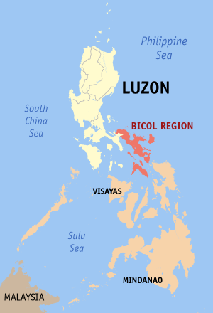
Steve,where is Bicol located,near Manila?
0 likes   
Visit the Caribbean-Central America Weather Thread where you can find at first post web cams,radars
and observations from Caribbean basin members Click Here

oaba09
S2K Supporter
S2K Supporter
Posts: 1496
Age: 38
Joined: Thu Oct 01, 2009 10:02 am
Location: Valenzuela, Philippines
Contact:

Re: WPAC : TYPHOON MIRINAE (23W)=Metro Manila under Signal #2

#1215 Postby oaba09 » Thu Oct 29, 2009 8:42 pm

cycloneye wrote:
Aslkahuna wrote:30/1800Z would be 0200 Saturday as the RP is 16 hours ahead of Greenwich with midnight at 1600Z. A lot of the convection is on the south side of the storm so the Bicol region would not be a place to be headed for right now.

Steve


Steve,where is Bicol located,near Manila?


Bicol is located at the southeastern most portion of luzon island

Image
0 likes   

dexterlabio
Category 5
Category 5
Posts: 3468
Joined: Sat Oct 24, 2009 11:50 pm

Re:

#1216 Postby dexterlabio » Thu Oct 29, 2009 8:47 pm

HURAKAN wrote:Image

Powerful eye


do you think there will be an eye visible before touching down to luzon? it's core is still some 300 or 400 kms away from its target (northern quezon-metro manila), and i am afraid that some things might occur unexpectedly O_O we are going to the mall to buy flashlights, preparing for a wide blackout that may happen when mirinae reached our area.
0 likes   
Personal Forecast Disclaimer:
The posts in this forum are NOT official forecast and should not be used as such. They are just the opinion of the poster and may or may not be backed by sound meteorological data. They are NOT endorsed by any professional institution or storm2k.org. For official information, please refer to the NHC and NWS products.

dataclese
Tropical Low
Tropical Low
Posts: 11
Joined: Thu Oct 29, 2009 3:21 pm

Re: WPAC : TYPHOON MIRINAE (23W)=Metro Manila under Signal #2

#1217 Postby dataclese » Thu Oct 29, 2009 8:50 pm

This is a nice link. Camera that pans the waterfront in Manila every once in a while and shows several recent loops:

http://www.earthtv.com/en/camera-locati ... owntown-en
0 likes   

User avatar
breeze
Category 5
Category 5
Posts: 9110
Age: 62
Joined: Sat Feb 08, 2003 4:55 pm
Location: Lawrenceburg, TN

Re: WPAC : TYPHOON MIRINAE (23W)=Metro Manila under Signal #2

#1218 Postby breeze » Thu Oct 29, 2009 8:53 pm

dataclese wrote:This is a nice link. Camera that pans the waterfront in Manila every once in a while and shows several recent loops:

http://www.earthtv.com/en/camera-locati ... owntown-en


Thanks! I've been on Google for over an hour trying to find a decent webcam view.
0 likes   

ozonepete
Professional-Met
Professional-Met
Posts: 4743
Joined: Mon Sep 07, 2009 3:23 pm
Location: From Ozone Park, NYC / Now in Brooklyn, NY

Re: WPAC : TYPHOON MIRINAE (23W)=Metro Manila under Signal #2

#1219 Postby ozonepete » Thu Oct 29, 2009 8:56 pm

dataclese wrote:This is a nice link. Camera that pans the waterfront in Manila every once in a while and shows several recent loops:

http://www.earthtv.com/en/camera-locati ... owntown-en


Very cool! Thanks.
0 likes   

ozonepete
Professional-Met
Professional-Met
Posts: 4743
Joined: Mon Sep 07, 2009 3:23 pm
Location: From Ozone Park, NYC / Now in Brooklyn, NY

Re: Re:

#1220 Postby ozonepete » Thu Oct 29, 2009 8:59 pm

dexterlabio wrote:
HURAKAN wrote:Image

Powerful eye


do you think there will be an eye visible before touching down to luzon? it's core is still some 300 or 400 kms away from its target (northern quezon-metro manila), and i am afraid that some things might occur unexpectedly O_O we are going to the mall to buy flashlights, preparing for a wide blackout that may happen when mirinae reached our area.


I posted a little while ago and said there may an eye visible on conventional satellite briefly in the next few hours but it looks like it's too late. This is already interacting with land which stop any strengthening and more than likely will weaken it some.
Last edited by ozonepete on Thu Oct 29, 2009 9:01 pm, edited 1 time in total.
0 likes   


Return to “2009”

Who is online

Users browsing this forum: No registered users and 6 guests