

This seems a longshot, but the CMC, GFS and EURO all show some sort of cutoff low forming at the end of a digging trough in the central Atlantic in the 4-5 day period.
Canadian at 4 days
http://moe.met.fsu.edu/cgi-bin/cmctc2.c ... hour=096hr
Canadian at 5 days
http://moe.met.fsu.edu/cgi-bin/cmctc2.c ... hour=120hr
GFS at 5 days
http://moe.met.fsu.edu/cgi-bin/gfstc2.c ... hour=120hr
My bet is no tropical development, but no one ever was harmed from keeping an eye out.
Possible tropical/subtropical development in central Atlanti
Moderator: S2k Moderators
Forum rules

The posts in this forum are NOT official forecasts and should not be used as such. They are just the opinion of the poster and may or may not be backed by sound meteorological data. They are NOT endorsed by any professional institution or STORM2K. For official information, please refer to products from the National Hurricane Center and National Weather Service.
-
wxman57

- Moderator-Pro Met

- Posts: 23172
- Age: 68
- Joined: Sat Jun 21, 2003 8:06 pm
- Location: Houston, TX (southwest)
Re: Possible tropical/subtropical development in central Atlanti
Looks like a big upper low with a surface reflection in a high-shear environment. With what the NHC has named these days, who knows...
0 likes

Re: Possible tropical/subtropical development in central Atlanti
From Dr. Jeff Master's blog today:
...a non-tropical low pressure system is expected to develop in the middle-Atlantic on Monday, and may spend enough time over water to acquire some tropical characteristics and become Subtropical Storm Ida
http://www.wunderground.com/blog/JeffMa ... rynum=1365
...a non-tropical low pressure system is expected to develop in the middle-Atlantic on Monday, and may spend enough time over water to acquire some tropical characteristics and become Subtropical Storm Ida
http://www.wunderground.com/blog/JeffMa ... rynum=1365
0 likes


-
cycloneye

- Admin

- Posts: 149276
- Age: 69
- Joined: Thu Oct 10, 2002 10:54 am
- Location: San Juan, Puerto Rico
Re: Possible tropical/subtropical development in central Atlanti
That low is starting to take shape in the Northcentral Atlantic.The question is if it will have time to make the transition to subtropical before it moves north to northeastward.

0 likes
Visit the Caribbean-Central America Weather Thread where you can find at first post web cams,radars
and observations from Caribbean basin members Click Here
and observations from Caribbean basin members Click Here
-
wxman57
- Moderator-Pro Met
- Posts: 23172
- Age: 68
- Joined: Sat Jun 21, 2003 8:06 pm
- Location: Houston, TX (southwest)
Re: Possible tropical/subtropical development in central Atlanti
No, the question is whether the NHC is going to name another occluded low either out in the middle of the ocean or by the Azores. Such lows would never have been named in the past.
0 likes


-
cycloneye
- Admin
- Posts: 149276
- Age: 69
- Joined: Thu Oct 10, 2002 10:54 am
- Location: San Juan, Puerto Rico
Re: Possible tropical/subtropical development in central Atlanti
TROPICAL WEATHER OUTLOOK
NWS TPC/NATIONAL HURRICANE CENTER MIAMI FL
200 PM EDT SAT OCT 31 2009
FOR THE NORTH ATLANTIC...CARIBBEAN SEA AND THE GULF OF MEXICO...
A NON-TROPICAL GALE CENTER IS LOCATED ABOUT 750 MILES EAST-SOUTHEAST
OF BERMUDA. TRANSITION OF THIS LOW INTO A SUBTROPICAL CYCLONE
APPEARS UNLIKELY AT THIS TIME. THERE IS A LOW CHANCE...LESS THAN
30 PERCENT...OF THIS SYSTEM BECOMING A SUBTROPICAL CYCLONE AS IT
MOVES NORTHWESTWARD TO NORTHWARD DURING THE NEXT 48 HOURS.
TROPICAL CYCLONE FORMATION IS NOT EXPECTED DURING THE NEXT 48 HOURS.
$$
FORECASTER PASCH/CANGIALOSI
0 likes
Visit the Caribbean-Central America Weather Thread where you can find at first post web cams,radars
and observations from Caribbean basin members Click Here
and observations from Caribbean basin members Click Here
-
cycloneye
- Admin
- Posts: 149276
- Age: 69
- Joined: Thu Oct 10, 2002 10:54 am
- Location: San Juan, Puerto Rico
Re: Possible tropical/subtropical development in central Atlanti
TROPICAL WEATHER OUTLOOK
NWS TPC/NATIONAL HURRICANE CENTER MIAMI FL
800 PM EDT SAT OCT 31 2009
FOR THE NORTH ATLANTIC...CARIBBEAN SEA AND THE GULF OF MEXICO...
A NON-TROPICAL GALE CENTER IS LOCATED ABOUT 850 MILES EAST-SOUTHEAST
OF BERMUDA. THIS LOW COULD SLOWLY ACQUIRE SOME SUBTROPICAL
CHARACTERISTICS AS IT BEGINS TO MOVE NORTHWESTWARD AND THEN
NORTHWARD OVER THE NEXT COUPLE OF DAYS. THERE IS A LOW CHANCE...
LESS THAN 30 PERCENT...OF THIS SYSTEM BECOMING A SUBTROPICAL CYCLONE
DURING THE NEXT 48 HOURS.
ELSEWHERE...TROPICAL OR SUBTROPICAL CYCLONE FORMATION IS NOT
EXPECTED DURING THE NEXT 48 HOURS.
$$
FORECASTER BRENNAN
0 likes
Visit the Caribbean-Central America Weather Thread where you can find at first post web cams,radars
and observations from Caribbean basin members Click Here
and observations from Caribbean basin members Click Here


-
cycloneye
- Admin
- Posts: 149276
- Age: 69
- Joined: Thu Oct 10, 2002 10:54 am
- Location: San Juan, Puerto Rico
Re: Possible tropical/subtropical development in central Atlanti
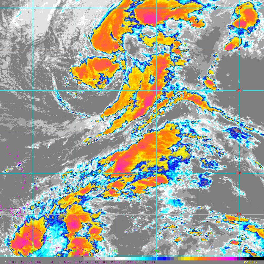
Floater 1 is over it.


0 likes
Visit the Caribbean-Central America Weather Thread where you can find at first post web cams,radars
and observations from Caribbean basin members Click Here
and observations from Caribbean basin members Click Here
-
cycloneye
- Admin
- Posts: 149276
- Age: 69
- Joined: Thu Oct 10, 2002 10:54 am
- Location: San Juan, Puerto Rico
Re: Possible tropical/subtropical development in central Atlanti
TROPICAL WEATHER OUTLOOK
NWS TPC/NATIONAL HURRICANE CENTER MIAMI FL
700 AM EST SUN NOV 1 2009
FOR THE NORTH ATLANTIC...CARIBBEAN SEA AND THE GULF OF MEXICO...
A NON-TROPICAL GALE CENTER IS LOCATED ABOUT 700 MILES EAST
OF BERMUDA. THIS LOW HAS THE POTENTIAL TO ACQUIRE SOME SUBTROPICAL
CHARACTERISTICS OVER THE NEXT COUPLE OF DAYS AS IT MOVES
NORTHWESTWARD AND THEN NORTHWARD. THERE IS A LOW CHANCE...LESS THAN
30 PERCENT...OF THIS SYSTEM BECOMING A SUBTROPICAL CYCLONE DURING
THE NEXT 48 HOURS. FOR ADDITIONAL INFORMATION ON THIS SYSTEM...
REFER TO HIGH SEAS FORECASTS ISSUED BY THE NATIONAL WEATHER SERVICE
UNDER AWIPS HEADER NFDHSFAT1 AND WMO HEADER FZNT01 KWBC.
ELSEWHERE...TROPICAL OR SUBTROPICAL CYCLONE FORMATION IS NOT
EXPECTED DURING THE NEXT 48 HOURS.
$$
FORECASTER BLAKE
0 likes
Visit the Caribbean-Central America Weather Thread where you can find at first post web cams,radars
and observations from Caribbean basin members Click Here
and observations from Caribbean basin members Click Here
-
cycloneye
- Admin
- Posts: 149276
- Age: 69
- Joined: Thu Oct 10, 2002 10:54 am
- Location: San Juan, Puerto Rico
Re: Possible tropical/subtropical development in central Atlanti
Thread is locked as is invest 96L.Continue the discussions about this system at the 96L thread at Active Storms forum.
0 likes
Visit the Caribbean-Central America Weather Thread where you can find at first post web cams,radars
and observations from Caribbean basin members Click Here
and observations from Caribbean basin members Click Here
Who is online
Users browsing this forum: IsabelaWeather and 211 guests