TROPICAL WEATHER OUTLOOK
NWS TPC/NATIONAL HURRICANE CENTER MIAMI FL
700 PM EST MON NOV 2 2009
FOR THE NORTH ATLANTIC...CARIBBEAN SEA AND THE GULF OF MEXICO...
SHOWER AND THUNDERSTORM ACTIVITY ASSOCIATED WITH A TROUGH OF LOW
PRESSURE IN THE EXTREME SOUTHWESTERN CARIBBEAN SEA HAS CHANGED
LITTLE IN ORGANIZATION OVER THE PAST FEW HOURS. SOME SLOW
DEVELOPMENT IS POSSIBLE AS THIS SYSTEM MOVES VERY LITTLE OVER THE
NEXT COUPLE OF DAYS. THERE IS A LOW CHANCE...LESS THAN 30
PERCENT...OF THIS SYSTEM BECOMING A TROPICAL CYCLONE DURING THE
NEXT 48 HOURS.
ELSEWHERE...TROPICAL CYCLONE FORMATION IS NOT EXPECTED DURING THE
NEXT 48 HOURS.
$$
FORECASTER BERG
Development in the SW Caribbean?
Moderator: S2k Moderators
Forum rules

The posts in this forum are NOT official forecasts and should not be used as such. They are just the opinion of the poster and may or may not be backed by sound meteorological data. They are NOT endorsed by any professional institution or STORM2K. For official information, please refer to products from the National Hurricane Center and National Weather Service.
-
cycloneye

- Admin

- Posts: 149772
- Age: 69
- Joined: Thu Oct 10, 2002 10:54 am
- Location: San Juan, Puerto Rico
Re: Development in the SW Caribbean?
0 likes
Visit the Caribbean-Central America Weather Thread where you can find at first post web cams,radars
and observations from Caribbean basin members Click Here
and observations from Caribbean basin members Click Here
Re: Development in the SW Caribbean?
I take the weak bluff comment back. This has the best spin of anything yet in that area. But 2009 has had a knack of teasing and "poof"!
0 likes
-
cycloneye
- Admin
- Posts: 149772
- Age: 69
- Joined: Thu Oct 10, 2002 10:54 am
- Location: San Juan, Puerto Rico
Re: Development in the SW Caribbean?

0 likes
Visit the Caribbean-Central America Weather Thread where you can find at first post web cams,radars
and observations from Caribbean basin members Click Here
and observations from Caribbean basin members Click Here
-
gatorcane

- S2K Supporter

- Posts: 23708
- Age: 48
- Joined: Sun Mar 13, 2005 3:54 pm
- Location: Boca Raton, FL
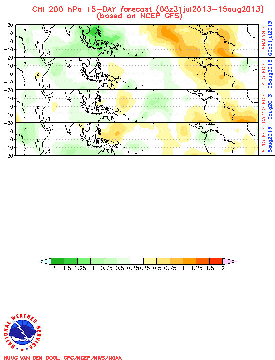
The 40-day chi shows rising air across much of the Atlantic basin, at least for the next couple of weeks, then the pattern switches to more sinking air towards the end of November. This graphic helps support some WCAR development over the next couple of weeks. Also, it's interesting to note the general synoptics for the Eastern GOM, WCAR, through Florida and the Bahamas is very late summer-like still, and this region has still not seen the usual season-ending cold front penetrate through yet (albeit a cold front did make it through roughly 2 weeks ago but its duration was ephemeral at best).
http://www.cpc.ncep.noaa.gov/products/p ... JO/gfs.gif
Looking at the model guidance tonight shows several models are on board for some development of this system. Generally, looking at the consensus shows slow development followed by a slow drift to the North or NNW over the next week. It wouldn't surprise me if the low pressure manages to brush the coastline of Nicaragua/Honduras or move over land for sometime before entering the WCAR somewhere east of Belize. Then in the WCAR some development could happen out ahead of a frontal system sweeping through the Central and Eastern CONUS out about 7-10 days from now.
0 likes
-
Derek Ortt
-
Ivanhater

- Storm2k Moderator

- Posts: 11222
- Age: 39
- Joined: Fri Jul 01, 2005 8:25 am
- Location: Pensacola
Re: Development in the SW Caribbean?
Looking at the models, it seems to split the low pressure area, with one emerging off the yucatan heading north in the gulf. So I don't think this area there now is necessarily what the models are developing.
0 likes
Michael
-
wxman57

- Moderator-Pro Met

- Posts: 23176
- Age: 68
- Joined: Sat Jun 21, 2003 8:06 pm
- Location: Houston, TX (southwest)
Re:
Derek Ortt wrote:seems like it is organizing somewhat this evening with convection increasing near the strong mid level spin
Kind of surprised this is not yet an NHC invest yet given the spin, increasing convection, and model support. However, if the current trends continue, it probably will be one tomorrow
Surface obs indicated an LLC this afternoon. Deepening convection tonight could tighten it up and we could have a TD tomorrow. I agree, where's the invest? I expect code orange on the next update by the NHC.
0 likes

-
wxman57
- Moderator-Pro Met
- Posts: 23176
- Age: 68
- Joined: Sat Jun 21, 2003 8:06 pm
- Location: Houston, TX (southwest)
Re: Development in the SW Caribbean?
Ivanhater wrote:Looking at the models, it seems to split the low pressure area, with one emerging off the yucatan heading north in the gulf. So I don't think this area there now is necessarily what the models are developing.
That's the low that the Canadian develops. The GFS and EC move some energy/vorticity out of the East Pac northward to the Yucatan where they develop a second low. I think that this second low is probably bogus. The SW Caribbean is where to watch.
Note: 00Z GFS drops the 2nd Yucatan low. Let's see if/when EC does the same.
0 likes
-
Derek Ortt
-
Evil Jeremy

- S2K Supporter
- Posts: 5463
- Age: 32
- Joined: Mon Apr 10, 2006 2:10 pm
- Location: Los Angeles, CA
Re: Development in the SW Caribbean?
Wow, where did this one come from? Really, this just popped out of nowhere! Looking at this, it should be an invest yesterday. I think it will be upgraded to Orange in an hour (and should be invested within the hour). A couple weeks ago we spent most of a week following the will it/won't it drama of an invest in this area, but this just came out of no where. Being in South Florida, should I be concerned?
0 likes
Frances 04 / Jeanne 04 / Katrina 05 / Wilma 05 / Fay 08 / Debby 12 / Andrea 13 / Colin 16 / Hermine 16 / Matthew 16 / Irma 17

Re: Development in the SW Caribbean?
Evil Jeremy wrote:Wow, where did this one come from? Really, this just popped out of nowhere! Looking at this, it should be an invest yesterday. I think it will be upgraded to Orange in an hour (and should be invested within the hour). A couple weeks ago we spent most of a week following the will it/won't it drama of an invest in this area, but this just came out of no where. Being in South Florida, should I be concerned?
I would be concerned since its developing and its south of Florida. This time of year its usually going to move north most of the time. Their are exceptions though.
Last edited by boca on Tue Nov 03, 2009 12:29 am, edited 1 time in total.
0 likes
Re: Development in the SW Caribbean?
This looks like a depression already with the banding structure which is developing. This isn't even an invest yet.
http://metofis.rsmas.miami.edu/~dortt/s ... 1_loop.gif
http://metofis.rsmas.miami.edu/~dortt/s ... 1_loop.gif
0 likes
-
SouthFLTropics

- Category 5

- Posts: 4258
- Age: 50
- Joined: Thu Aug 14, 2003 8:04 am
- Location: Port St. Lucie, Florida
Re: Development in the SW Caribbean?
boca wrote:This looks like a depression already with the banding structure which is developing. This isn't even an invest yet.
http://metofis.rsmas.miami.edu/~dortt/s ... 1_loop.gif
Maybe they are afraid they are going to jinx it...Given the way the season has gone as soon as they label it an invest it will die off. That being said, I don't like the look of a possible developing system to the South of FLA this time of year, especially with all of the untapped heat content in the Western Caribbean.
SFT
0 likes
Fourth Generation Florida Native
Personal Storm History: David 79, Andrew 92, Erin 95, Floyd 99, Irene 99, Frances 04, Jeanne 04, Wilma 05, Matthew 16, Irma 17, Ian 22, Nicole 22, Milton 24
Personal Storm History: David 79, Andrew 92, Erin 95, Floyd 99, Irene 99, Frances 04, Jeanne 04, Wilma 05, Matthew 16, Irma 17, Ian 22, Nicole 22, Milton 24
-
Derek Ortt
-
cycloneye
- Admin
- Posts: 149772
- Age: 69
- Joined: Thu Oct 10, 2002 10:54 am
- Location: San Juan, Puerto Rico
Re: Development in the SW Caribbean?
The ECMWF continues to show a tropical storm comming out of Western Caribbean and entering the GOM.Here is the loop of the 00z run.
http://www.ecmwf.int/products/forecasts ... 00!!!step/
http://www.ecmwf.int/products/forecasts ... 00!!!step/
0 likes
Visit the Caribbean-Central America Weather Thread where you can find at first post web cams,radars
and observations from Caribbean basin members Click Here
and observations from Caribbean basin members Click Here
-
wxman57
- Moderator-Pro Met
- Posts: 23176
- Age: 68
- Joined: Sat Jun 21, 2003 8:06 pm
- Location: Houston, TX (southwest)
Re: Development in the SW Caribbean?
Convection diminished in the past 6 hours. Most of the spin you're seeing is aloft, but surface obs did indicate a weak LLC yesterday. Euro doesn't really develop a closed low, neither does the Canadian now, though the Canadian still tries to bring something across into the BoC from the Pacific.
0 likes
-
cycloneye
- Admin
- Posts: 149772
- Age: 69
- Joined: Thu Oct 10, 2002 10:54 am
- Location: San Juan, Puerto Rico
Re: Development in the SW Caribbean?
Code Orange
TROPICAL WEATHER OUTLOOK
NWS TPC/NATIONAL HURRICANE CENTER MIAMI FL
700 AM EST TUE NOV 3 2009
FOR THE NORTH ATLANTIC...CARIBBEAN SEA AND THE GULF OF MEXICO...
A WEAK AREA OF SURFACE LOW PRESSURE HAS FORMED JUST EAST OF COSTA
RICA IN THE EXTREME SOUTHWESTERN CARIBBEAN SEA. ALTHOUGH SHOWER
ACTIVITY REMAINS DISORGANIZED...UPPER-LEVEL WINDS ARE FAVORABLE FOR
SOME CONTINUED DEVELOPMENT OVER THE NEXT COUPLE OF DAYS AS THE
SYSTEM REMAINS NEARLY STATIONARY. THERE IS A MEDIUM CHANCE...30 TO
50 PERCENT...OF THIS SYSTEM BECOMING A TROPICAL CYCLONE DURING THE
NEXT 48 HOURS.
ELSEWHERE...TROPICAL CYCLONE FORMATION IS NOT EXPECTED DURING THE
NEXT 48 HOURS.
$$
FORECASTER FRANKLIN
0 likes
Visit the Caribbean-Central America Weather Thread where you can find at first post web cams,radars
and observations from Caribbean basin members Click Here
and observations from Caribbean basin members Click Here
-
gatorcane
- S2K Supporter
- Posts: 23708
- Age: 48
- Joined: Sun Mar 13, 2005 3:54 pm
- Location: Boca Raton, FL
The 00Z GFS moves it slowly NNW towards the WCAR and Yucatan area over the next week. Seems reasonable to me and that is what I am going with as far as where it heads.
http://www.nco.ncep.noaa.gov/pmb/nwprod ... n_168l.gif
http://www.nco.ncep.noaa.gov/pmb/nwprod ... n_168l.gif
0 likes
-
cycloneye
- Admin
- Posts: 149772
- Age: 69
- Joined: Thu Oct 10, 2002 10:54 am
- Location: San Juan, Puerto Rico
Re: Development in the SW Caribbean?
Is invest 97L so the thread is locked.Go to active storms forum to continue the discussions at the 97L thread.Link to 97L thread below.
viewtopic.php?f=59&t=106963&p=1939513#p1939513
viewtopic.php?f=59&t=106963&p=1939513#p1939513
0 likes
Visit the Caribbean-Central America Weather Thread where you can find at first post web cams,radars
and observations from Caribbean basin members Click Here
and observations from Caribbean basin members Click Here
Who is online
Users browsing this forum: Google [Bot], Google Adsense [Bot], hurricanes1234, NotSparta and 143 guests