
ATL : TROPICAL DEPRESSION IDA
Moderator: S2k Moderators
-
cycloneye

- Admin

- Posts: 149214
- Age: 69
- Joined: Thu Oct 10, 2002 10:54 am
- Location: San Juan, Puerto Rico
Re: ATL : TROPICAL STORM IDA Update=Winds increased to 65 mph
I dont think Ida will do like what Jeanne in 1980 did but anything can happen as the tropics many times offer surprises.
0 likes
Visit the Caribbean-Central America Weather Thread where you can find at first post web cams,radars
and observations from Caribbean basin members Click Here
and observations from Caribbean basin members Click Here

-
ozonepete
- Professional-Met

- Posts: 4743
- Joined: Mon Sep 07, 2009 3:23 pm
- Location: From Ozone Park, NYC / Now in Brooklyn, NY
Re:
CrazyC83 wrote:It seems to be moving north-northwest at the moment based on the two fixes. It might just run the Cabo Gracios region, which is pretty flat.
Good point. Both you and macrocane pointed out that the eastern region is actually not mountainous and is in fact very flat. So we have to watch the track. Any more northward motion could keep it from crossing the mountains at all...
Just edited to say I meant the good point was about the terrain, not the direction.
Last edited by ozonepete on Wed Nov 04, 2009 6:23 pm, edited 2 times in total.
0 likes


Re: ATL : TROPICAL STORM IDA
This reminds me to Humberto and Lorenzo forming and intensifying into hurricanes very close to land and in a rapid way, though Ida is still not a hurricane I wouldn't be surprised if it is upgraded on the next full advisory.
0 likes
-
cycloneye
- Admin
- Posts: 149214
- Age: 69
- Joined: Thu Oct 10, 2002 10:54 am
- Location: San Juan, Puerto Rico
Re: ATL : TROPICAL STORM IDA - Models
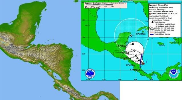
18z GFDL is more east than the 12z run.Run ends just south of Western tip of Cuba.
757
WHXX04 KWBC 042320
CHGQLM
ATTENTION...NATIONAL HURRICANE CENTER
NCEP COUPLED GFDL HURRICANE MODEL FORECAST MADE FOR
TROPICAL STORM IDA 11L
INITIAL TIME 18Z NOV 4
DISCLAIMER ... THIS INFORMATION IS PROVIDED AS GUIDANCE. IT
REQUIRES INTERPRETATION BY HURRICANE SPECIALISTS AND SHOULD
NOT BE CONSIDERED AS A FINAL PRODUCT. PLEASE SEE THE TPC/NHC
OFFICIAL FORECAST.
FORECAST STORM POSITION
HOUR LATITUDE LONGITUDE HEADING/SPEED(KT)
0 11.8 82.3 300./ 5.0
6 11.9 82.3 9./ 1.2
12 12.0 82.3 340./ 1.5
18 12.1 82.2 47./ 1.7
24 12.7 82.0 15./ 5.9
30 13.1 82.2 342./ 4.3
36 13.4 82.0 33./ 3.3
42 14.2 81.9 7./ 7.7
48 14.7 81.9 0./ 5.4
54 15.2 81.8 12./ 4.7
60 15.5 81.7 17./ 3.8
66 16.2 81.5 16./ 7.4
72 16.8 81.5 357./ 5.6
78 17.2 81.6 342./ 4.3
84 17.6 81.9 323./ 4.6
90 18.0 82.0 345./ 4.5
96 18.7 82.4 331./ 7.1
102 19.0 82.5 336./ 3.1
108 19.8 82.7 350./ 8.8
114 20.6 83.1 330./ 8.5
120 21.3 83.6 324./ 8.5
126 21.8 84.0 323./ 6.2
0 likes
Visit the Caribbean-Central America Weather Thread where you can find at first post web cams,radars
and observations from Caribbean basin members Click Here
and observations from Caribbean basin members Click Here
-
ozonepete
- Professional-Met
- Posts: 4743
- Joined: Mon Sep 07, 2009 3:23 pm
- Location: From Ozone Park, NYC / Now in Brooklyn, NY
Re:
Aric Dunn wrote:hehe.. Always a surprise in November..
likely be a hurricane by morning.. well let me rephrase they will likely upgrade by morning, could be a hurricane as early as 11pm
It has to do it by 2AM. It will be too close to land or on land by tomorrow morning.
0 likes
-
attallaman
Re: ATL : TROPICAL STORM IDA - Models
I just checked my email and I received one from the NHC about a system down south. I haven't been back here in awhile, is this the forum discussing the system the NHC is talking about? One of the TV stations in NOLA last night mentioned something possibly developing in the BOC. What's the water temps running now in the GOM since cooler weather has made it's way into my region? Tropics have been quiet this year and as far as I'm concerned they can continue to remain quiet. What's forecasted out of this system, a big rain event for someone in the GOM region or are chances for further development not that great?
0 likes
-
HouTXmetro

- Category 5

- Posts: 3949
- Joined: Sun Jun 13, 2004 6:00 pm
- Location: District of Columbia, USA
Re: ATL : TROPICAL STORM IDA - Models
ROCK wrote:Ivanhater wrote:18z GFS, keeps Ida offshore
also closing off something off of Texas?....96hr heading toward the Yucatan.

Jeff Lindner and local mets were discussing something potentially forming in BOC and moving towards Texas/Louisiana.
Last edited by HouTXmetro on Wed Nov 04, 2009 6:26 pm, edited 1 time in total.
0 likes
[Disclaimer: My Amateur Opinion, please defer to your local authorities or the NHC for Guidance.]


-
Ivanhater

- Storm2k Moderator

- Posts: 11221
- Age: 39
- Joined: Fri Jul 01, 2005 8:25 am
- Location: Pensacola
Re:
gatorcane wrote::uarrow:
One thing to watch for. The models that have it more left certainly do not have Ida as strong as it is now and Ida is definitely deepending pretty quickly at the moment....so we could see some models shift back to the right like the GFDL did here to join the ECMWF/UKMET
In this case Gator, seems that there will be a blocking high preventing any turn to the east like climo would suggest. Still have time for the longrange to work out.
Notice the gfdl run keeps it offshore as well, like the gfs run? That is interesting
0 likes
Michael
Re: ATL : TROPICAL STORM IDA
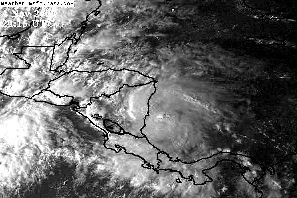
For the first time this year that black IR might mean something besides making a fool of me for pointing it out:

0 likes
-
cycloneye
- Admin
- Posts: 149214
- Age: 69
- Joined: Thu Oct 10, 2002 10:54 am
- Location: San Juan, Puerto Rico
Re: ATL : TROPICAL STORM IDA - Models
Holy cow!!! A cat 5 in Western Caribbean in this 18z GFDL run 
http://moe.met.fsu.edu/cgi-bin/gfdltc2. ... =Animation

http://moe.met.fsu.edu/cgi-bin/gfdltc2. ... =Animation
0 likes
Visit the Caribbean-Central America Weather Thread where you can find at first post web cams,radars
and observations from Caribbean basin members Click Here
and observations from Caribbean basin members Click Here
Re:
gatorcane wrote:The 18Z GFDL goes crazy with Ida taking it to major hurricanes strength in the NW Caribbean south of Western tip of Cuba...with winds of 140 knots.
Ignore GFDL. It's on probation this year. Only use it with storms with an eye.
0 likes
-
wxman57

- Moderator-Pro Met

- Posts: 23170
- Age: 68
- Joined: Sat Jun 21, 2003 8:06 pm
- Location: Houston, TX (southwest)
Re: ATL : TROPICAL STORM IDA
Sanibel wrote:For the first time this year that black IR might mean something besides making a fool of me for pointing it out:
http://www.ssd.noaa.gov/goes/flt/t2/avn-l.jpg

0 likes
Who is online
Users browsing this forum: No registered users and 11 guests