ATL : TROPICAL DEPRESSION IDA
Moderator: S2k Moderators
-
Evil Jeremy

- S2K Supporter

- Posts: 5463
- Age: 32
- Joined: Mon Apr 10, 2006 2:10 pm
- Location: Los Angeles, CA
Re: ATL : TROPICAL STORM IDA
I smell a hurricane warning on the horizon. As well as an upgrade to hurricane. It looks like one, and it looks like it is getting stronger. Anyways, I am watching intently here in South Florida. I am not worrying about anything yet, but this could be a potential player for us down the road.
0 likes
Frances 04 / Jeanne 04 / Katrina 05 / Wilma 05 / Fay 08 / Debby 12 / Andrea 13 / Colin 16 / Hermine 16 / Matthew 16 / Irma 17


Re: ATL : TROPICAL STORM IDA
We've had intermittent rains since 5 hours ago, they're not heavy showers just a nice rain but things could change depending on how the system on EPAC and Ida move. We're receiving moisture from both systems, if Ida moves into northwestern Caribbean and the low in the Pacific moves closer to Central America we would have a scenario very similar to Stan wich is not good. I like rainy days but not in excess.
0 likes
-
Derek Ortt
-
Dean4Storms
- S2K Supporter
- Posts: 6358
- Age: 63
- Joined: Sun Aug 31, 2003 1:01 pm
- Location: Miramar Bch. FL
-
Blown Away

- S2K Supporter
- Posts: 10253
- Joined: Wed May 26, 2004 6:17 am
Re: ATL : TROPICAL STORM IDA
Evil Jeremy wrote:I smell a hurricane warning on the horizon. As well as an upgrade to hurricane. It looks like one, and it looks like it is getting stronger. Anyways, I am watching intently here in South Florida. I am not worrying about anything yet, but this could be a potential player for us down the road.
Yep, Ida projected to be in the Yucatan Channel in 5 days. Climatology should give Ida an easterly component to the track after day 5. Difficult to say on intensity, but the NHC has Ida strengthening slightly from day 4 to 5. I wouldn't mind a moderate TS racing across SFL ahead of a trough followed by some cool air.
0 likes
Hurricane Eye Experience: David 79, Irene 99, Frances 04, Jeanne 04, Wilma 05… Hurricane Brush Experience: Andrew 92, Erin 95, Floyd 99, Matthew 16, Irma 17, Ian 22, Nicole 22…
-
HurricaneBelle

- S2K Supporter
- Posts: 1209
- Joined: Sun Aug 27, 2006 6:12 pm
- Location: Clearwater, FL
Re: ATL : TROPICAL STORM IDA - Models
Blown_away wrote:18Z GFDL, I know it's highly and hopefully unlikely, but I'm amazed to see a Cat 5 model in November.

Those projected winds are aloft. This would translate to Cat 4 winds at the surface.
0 likes
-
Dean4Storms
- S2K Supporter
- Posts: 6358
- Age: 63
- Joined: Sun Aug 31, 2003 1:01 pm
- Location: Miramar Bch. FL
Re: ATL : TROPICAL STORM IDA - Models
Blown_away wrote:18Z GFDL, I know it's highly and hopefully unlikely, but I'm amazed to see a Cat 5 model in November.
So you are "Blown away"??
0 likes
-
lrak

- S2K Supporter
- Posts: 1770
- Age: 59
- Joined: Thu Jun 21, 2007 2:48 pm
- Location: Corpus Christi, TX
Re: ATL : TROPICAL STORM IDA
http://magicseaweed.com/Bob-Hall-Pier-Surf-Report/361/
check out the surf forecast, 10 FEET, I hope the jetties can hold it. Also those wave and wind models are wacked on this site, it looks like the storm will do a loop dee loop and hit S. Florida.
Texas ain't got surf.
http://magicseaweed.com/photoLab/viewPh ... toId=76323
check out the surf forecast, 10 FEET, I hope the jetties can hold it. Also those wave and wind models are wacked on this site, it looks like the storm will do a loop dee loop and hit S. Florida.
Texas ain't got surf.
http://magicseaweed.com/photoLab/viewPh ... toId=76323
0 likes
AKA karl
Also
Personal Forecast Disclaimer:
My posts on this forum are NOT official forecast and should not be used as such. My posts are my basic observations and are definitely not backed by any "well some" meteorological knowledge. For official information, please refer to the NHC and NWS products.
Also
Personal Forecast Disclaimer:
My posts on this forum are NOT official forecast and should not be used as such. My posts are my basic observations and are definitely not backed by any "well some" meteorological knowledge. For official information, please refer to the NHC and NWS products.

-
HurricaneBelle
- S2K Supporter
- Posts: 1209
- Joined: Sun Aug 27, 2006 6:12 pm
- Location: Clearwater, FL
Re: ATL : TROPICAL STORM IDA
10PM advisory info (55 KT):
TROPICAL STORM CENTER LOCATED NEAR 12.5N 83.1W AT 05/0300Z
POSITION ACCURATE WITHIN 15 NM
PRESENT MOVEMENT TOWARD THE NORTHWEST OR 315 DEGREES AT 6 KT
ESTIMATED MINIMUM CENTRAL PRESSURE 995 MB
MAX SUSTAINED WINDS 55 KT WITH GUSTS TO 65 KT.
TROPICAL STORM CENTER LOCATED NEAR 12.5N 83.1W AT 05/0300Z
POSITION ACCURATE WITHIN 15 NM
PRESENT MOVEMENT TOWARD THE NORTHWEST OR 315 DEGREES AT 6 KT
ESTIMATED MINIMUM CENTRAL PRESSURE 995 MB
MAX SUSTAINED WINDS 55 KT WITH GUSTS TO 65 KT.
0 likes
-
cycloneye

- Admin

- Posts: 149744
- Age: 69
- Joined: Thu Oct 10, 2002 10:54 am
- Location: San Juan, Puerto Rico
Re: ATL : TROPICAL STORM IDA - Advisories
000
WTNT31 KNHC 050233
TCPAT1
BULLETIN
TROPICAL STORM IDA ADVISORY NUMBER 3
NWS TPC/NATIONAL HURRICANE CENTER MIAMI FL AL112009
1000 PM EST WED NOV 04 2009
...IDA APPROACHING THE EAST COAST OF NICARAGUA...
A HURRICANE WATCH IS IN EFFECT FOR THE EASTERN COAST OF NICARAGUA
FROM BLUEFIELDS NORTHWARD TO THE HONDURAS/NICARAGUA BORDER.
A HURRICANE WATCH MEANS THAT HURRICANE CONDITIONS ARE
POSSIBLE WITHIN THE WATCH AREA...GENERALLY WITHIN 36 HOURS.
A TROPICAL STORM WARNING REMAINS IN EFFECT FOR THE ENTIRE EASTERN
COAST OF NICARAGUA.
A TROPICAL STORM WARNING MEANS THAT TROPICAL STORM CONDITIONS ARE
EXPECTED SOMEWHERE WITHIN THE WARNING AREA WITHIN 24 HOURS.
AT 10 PM EST...0300 UTC...THE GOVERNMENT OF COLOMBIA HAS
DISCONTINUED THE TROPICAL STORM WARNING FOR THE ISLANDS OF SAN
ANDRES AND PROVIDENCIA.
FOR STORM INFORMATION SPECIFIC TO YOUR AREA...PLEASE MONITOR
PRODUCTS ISSUED BY YOUR NATIONAL METEOROLOGICAL SERVICE.
AT 1000 PM EST...0300 UTC...THE CENTER OF TROPICAL STORM IDA WAS
LOCATED NEAR LATITUDE 12.5 NORTH...LONGITUDE 83.1 WEST OR ABOUT 60
MILES... 95 KM...NORTHEAST OF BLUEFIELDS NICARAGUA.
IDA IS MOVING TOWARD THE NORTHWEST NEAR 7 MPH...11 KM/HR...AND A
GRADUAL TURN TO THE NORTH-NORTHWEST WITH A DECREASE IN FORWARD
SPEED IS EXPECTED DURING THE NEXT DAY OR TWO. ON THE FORECAST
TRACK...IDA SHOULD MAKE LANDFALL ALONG THE EAST COAST OF NICARAGUA
EARLY THURSDAY.
MAXIMUM SUSTAINED WINDS ARE NEAR 65 MPH...100 KM/HR...WITH HIGHER
GUSTS. SOME STRENGTHENING IS POSSIBLE...AND IDA COULD APPROACH
HURRICANE INTENSITY BEFORE MAKING LANDFALL.
TROPICAL STORM FORCE WINDS EXTEND OUTWARD UP TO 50 MILES...85 KM
FROM THE CENTER.
ESTIMATED MINIMUM CENTRAL PRESSURE IS 995 MB...29.38 INCHES.
IDA IS EXPECTED TO PRODUCE TOTAL RAINFALL ACCUMULATIONS OF 5 TO 7
INCHES OVER SAN ANDRES ISLAND WITH MAXIMUM AMOUNTS OF 12 INCHES
POSSIBLE. RAINFALL ACCUMULATIONS OF 15 TO 20 INCHES ARE EXPECTED
OVER EASTERN NICARAGUA AND EASTERN HONDURAS WITH MAXIMUM AMOUNTS OF
25 INCHES POSSIBLE. THESE RAINS COULD PRODUCE LIFE-THREATENING
FLASH FLOOD AND MUD SLIDES.
A STORM SURGE COULD RAISE WATER LEVELS BY AS MUCH AS 3 FEET ABOVE
GROUND LEVEL ALONG THE EAST COAST OF NICARAGUA...WITH LARGE AND
DANGEROUS BATTERING WAVES...NEAR AND TO THE NORTH OF WHERE THE
CENTER OF IDA MAKES LANDFALL.
...SUMMARY OF 1000 PM EST INFORMATION...
LOCATION...12.5N 83.1W
MAXIMUM SUSTAINED WINDS...65 MPH
PRESENT MOVEMENT...NORTHWEST OR 315 DEGREES AT 7 MPH
MINIMUM CENTRAL PRESSURE...995 MB
AN INTERMEDIATE ADVISORY WILL BE ISSUED BY THE NATIONAL HURRICANE
CENTER AT 100 AM EST FOLLOWED BY THE NEXT COMPLETE ADVISORY AT 400
AM EST.
$$
FORECASTER PASCH/ROBERTS
--------------------------------------------------------------------------------
000
WTNT41 KNHC 050235
TCDAT1
TROPICAL STORM IDA DISCUSSION NUMBER 3
NWS TPC/NATIONAL HURRICANE CENTER MIAMI FL AL112009
1000 PM EST WED NOV 04 2009
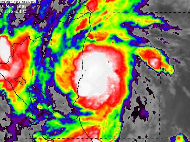
SINCE THE LAST AIRCRAFT PENETRATION OF THE STORM...THE CLOUD PATTERN
OF IDA HAS REMAINED WELL ORGANIZED WITH A PROMINENT COLD-TOPPED CDO
AND SOME BANDING FEATURES OVER THE NORTHERN SEMICIRCLE. A RECENT
SSMIS OVERPASS REVEALED A BANDING-TYPE EYE IN MICROWAVE IMAGERY.
DVORAK INTENSITY ESTIMATES WERE 45 KT FROM TAFB AND SAB BUT THESE
ARE CONSTRAINED BY THE RULES OF THE TECHNIQUE. BASED ON THE
EARLIER AIRCRAFT DATA AND CURRENT ORGANIZATION OF THE SYSTEM...THE
CURRENT INTENSITY IS ESTIMATED TO BE 55 KT. THE UPPER-LEVEL
OUTFLOW IS WELL DEFINED AND THERE REMAINS A SHORT PERIOD PRIOR TO
LANDFALL FOR IDA TO STRENGTHEN A LITTLE MORE. RAPID WEAKENING IS
LIKELY WHEN THE CYCLONE INTERACTS WITH THE MOUNTAINOUS TERRAIN OF
CENTRAL AMERICA. IDA IS PROJECTED TO MOVE BACK OVER THE WATERS OF
THE CARIBBEAN SEA IN ABOUT 3 DAYS. THE INTENSITY FORECAST IN THE
LATTER PART OF THE PERIOD IS HIGHLY UNCERTAIN...HOWEVER...BECAUSE
IT IS NOT CLEAR WHETHER THE TROPICAL CYCLONE WILL SURVIVE ITS
TRANSIT OVER LAND.
THE ESTIMATED INITIAL MOTION IS NOW NORTHWESTWARD OR 315/6. IDA IS
BEING STEERED BY THE FLOW BETWEEN A WEAK RIDGE OVER THE
NORTH-CENTRAL CARIBBEAN SEA AND A WEAK TROUGH OVER THE SOUTHWESTERN
GULF OF MEXICO. AS THE RIDGE BUILDS NORTHWARD OVER THE NEXT FEW
DAYS...THE TROPICAL CYCLONE SHOULD GRADUALLY TURN TOWARD THE
NORTH-NORTHWEST. MOST OF THE TRACK MODELS ARE IN FAIR AGREEMENT ON
A GENERAL NORTHWARD OR NORTH-NORTHWESTWARD MOTION...BUT VARY
SIGNIFICANTLY IN FORWARD SPEED. THE OFFICIAL FORECAST IS A BLEND
OF THE MODEL CONSENSUS AND THE PREVIOUS NHC TRACK.
THE BIGGEST IMPACT OF THIS SLOW-MOVING SYSTEM WILL LIKELY BE
LIFE-THREATENING FLASH FLOODS AND MUD SLIDES CAUSED BY EXTREMELY
HEAVY RAINS.
FORECAST POSITIONS AND MAX WINDS
INITIAL 05/0300Z 12.5N 83.1W 55 KT
12HR VT 05/1200Z 12.9N 83.6W 60 KT...INLAND
24HR VT 06/0000Z 13.5N 84.0W 40 KT...INLAND
36HR VT 06/1200Z 14.3N 84.4W 30 KT...INLAND
48HR VT 07/0000Z 15.1N 84.6W 25 KT...INLAND
72HR VT 08/0000Z 17.0N 85.0W 35 KT...OVER WATER
96HR VT 09/0000Z 19.5N 85.5W 40 KT
120HR VT 10/0000Z 21.5N 86.5W 45 KT
$$
FORECASTER PASCH/ROBERTS
WTNT31 KNHC 050233
TCPAT1
BULLETIN
TROPICAL STORM IDA ADVISORY NUMBER 3
NWS TPC/NATIONAL HURRICANE CENTER MIAMI FL AL112009
1000 PM EST WED NOV 04 2009
...IDA APPROACHING THE EAST COAST OF NICARAGUA...
A HURRICANE WATCH IS IN EFFECT FOR THE EASTERN COAST OF NICARAGUA
FROM BLUEFIELDS NORTHWARD TO THE HONDURAS/NICARAGUA BORDER.
A HURRICANE WATCH MEANS THAT HURRICANE CONDITIONS ARE
POSSIBLE WITHIN THE WATCH AREA...GENERALLY WITHIN 36 HOURS.
A TROPICAL STORM WARNING REMAINS IN EFFECT FOR THE ENTIRE EASTERN
COAST OF NICARAGUA.
A TROPICAL STORM WARNING MEANS THAT TROPICAL STORM CONDITIONS ARE
EXPECTED SOMEWHERE WITHIN THE WARNING AREA WITHIN 24 HOURS.
AT 10 PM EST...0300 UTC...THE GOVERNMENT OF COLOMBIA HAS
DISCONTINUED THE TROPICAL STORM WARNING FOR THE ISLANDS OF SAN
ANDRES AND PROVIDENCIA.
FOR STORM INFORMATION SPECIFIC TO YOUR AREA...PLEASE MONITOR
PRODUCTS ISSUED BY YOUR NATIONAL METEOROLOGICAL SERVICE.
AT 1000 PM EST...0300 UTC...THE CENTER OF TROPICAL STORM IDA WAS
LOCATED NEAR LATITUDE 12.5 NORTH...LONGITUDE 83.1 WEST OR ABOUT 60
MILES... 95 KM...NORTHEAST OF BLUEFIELDS NICARAGUA.
IDA IS MOVING TOWARD THE NORTHWEST NEAR 7 MPH...11 KM/HR...AND A
GRADUAL TURN TO THE NORTH-NORTHWEST WITH A DECREASE IN FORWARD
SPEED IS EXPECTED DURING THE NEXT DAY OR TWO. ON THE FORECAST
TRACK...IDA SHOULD MAKE LANDFALL ALONG THE EAST COAST OF NICARAGUA
EARLY THURSDAY.
MAXIMUM SUSTAINED WINDS ARE NEAR 65 MPH...100 KM/HR...WITH HIGHER
GUSTS. SOME STRENGTHENING IS POSSIBLE...AND IDA COULD APPROACH
HURRICANE INTENSITY BEFORE MAKING LANDFALL.
TROPICAL STORM FORCE WINDS EXTEND OUTWARD UP TO 50 MILES...85 KM
FROM THE CENTER.
ESTIMATED MINIMUM CENTRAL PRESSURE IS 995 MB...29.38 INCHES.
IDA IS EXPECTED TO PRODUCE TOTAL RAINFALL ACCUMULATIONS OF 5 TO 7
INCHES OVER SAN ANDRES ISLAND WITH MAXIMUM AMOUNTS OF 12 INCHES
POSSIBLE. RAINFALL ACCUMULATIONS OF 15 TO 20 INCHES ARE EXPECTED
OVER EASTERN NICARAGUA AND EASTERN HONDURAS WITH MAXIMUM AMOUNTS OF
25 INCHES POSSIBLE. THESE RAINS COULD PRODUCE LIFE-THREATENING
FLASH FLOOD AND MUD SLIDES.
A STORM SURGE COULD RAISE WATER LEVELS BY AS MUCH AS 3 FEET ABOVE
GROUND LEVEL ALONG THE EAST COAST OF NICARAGUA...WITH LARGE AND
DANGEROUS BATTERING WAVES...NEAR AND TO THE NORTH OF WHERE THE
CENTER OF IDA MAKES LANDFALL.
...SUMMARY OF 1000 PM EST INFORMATION...
LOCATION...12.5N 83.1W
MAXIMUM SUSTAINED WINDS...65 MPH
PRESENT MOVEMENT...NORTHWEST OR 315 DEGREES AT 7 MPH
MINIMUM CENTRAL PRESSURE...995 MB
AN INTERMEDIATE ADVISORY WILL BE ISSUED BY THE NATIONAL HURRICANE
CENTER AT 100 AM EST FOLLOWED BY THE NEXT COMPLETE ADVISORY AT 400
AM EST.
$$
FORECASTER PASCH/ROBERTS
--------------------------------------------------------------------------------
000
WTNT41 KNHC 050235
TCDAT1
TROPICAL STORM IDA DISCUSSION NUMBER 3
NWS TPC/NATIONAL HURRICANE CENTER MIAMI FL AL112009
1000 PM EST WED NOV 04 2009
SINCE THE LAST AIRCRAFT PENETRATION OF THE STORM...THE CLOUD PATTERN
OF IDA HAS REMAINED WELL ORGANIZED WITH A PROMINENT COLD-TOPPED CDO
AND SOME BANDING FEATURES OVER THE NORTHERN SEMICIRCLE. A RECENT
SSMIS OVERPASS REVEALED A BANDING-TYPE EYE IN MICROWAVE IMAGERY.
DVORAK INTENSITY ESTIMATES WERE 45 KT FROM TAFB AND SAB BUT THESE
ARE CONSTRAINED BY THE RULES OF THE TECHNIQUE. BASED ON THE
EARLIER AIRCRAFT DATA AND CURRENT ORGANIZATION OF THE SYSTEM...THE
CURRENT INTENSITY IS ESTIMATED TO BE 55 KT. THE UPPER-LEVEL
OUTFLOW IS WELL DEFINED AND THERE REMAINS A SHORT PERIOD PRIOR TO
LANDFALL FOR IDA TO STRENGTHEN A LITTLE MORE. RAPID WEAKENING IS
LIKELY WHEN THE CYCLONE INTERACTS WITH THE MOUNTAINOUS TERRAIN OF
CENTRAL AMERICA. IDA IS PROJECTED TO MOVE BACK OVER THE WATERS OF
THE CARIBBEAN SEA IN ABOUT 3 DAYS. THE INTENSITY FORECAST IN THE
LATTER PART OF THE PERIOD IS HIGHLY UNCERTAIN...HOWEVER...BECAUSE
IT IS NOT CLEAR WHETHER THE TROPICAL CYCLONE WILL SURVIVE ITS
TRANSIT OVER LAND.
THE ESTIMATED INITIAL MOTION IS NOW NORTHWESTWARD OR 315/6. IDA IS
BEING STEERED BY THE FLOW BETWEEN A WEAK RIDGE OVER THE
NORTH-CENTRAL CARIBBEAN SEA AND A WEAK TROUGH OVER THE SOUTHWESTERN
GULF OF MEXICO. AS THE RIDGE BUILDS NORTHWARD OVER THE NEXT FEW
DAYS...THE TROPICAL CYCLONE SHOULD GRADUALLY TURN TOWARD THE
NORTH-NORTHWEST. MOST OF THE TRACK MODELS ARE IN FAIR AGREEMENT ON
A GENERAL NORTHWARD OR NORTH-NORTHWESTWARD MOTION...BUT VARY
SIGNIFICANTLY IN FORWARD SPEED. THE OFFICIAL FORECAST IS A BLEND
OF THE MODEL CONSENSUS AND THE PREVIOUS NHC TRACK.
THE BIGGEST IMPACT OF THIS SLOW-MOVING SYSTEM WILL LIKELY BE
LIFE-THREATENING FLASH FLOODS AND MUD SLIDES CAUSED BY EXTREMELY
HEAVY RAINS.
FORECAST POSITIONS AND MAX WINDS
INITIAL 05/0300Z 12.5N 83.1W 55 KT
12HR VT 05/1200Z 12.9N 83.6W 60 KT...INLAND
24HR VT 06/0000Z 13.5N 84.0W 40 KT...INLAND
36HR VT 06/1200Z 14.3N 84.4W 30 KT...INLAND
48HR VT 07/0000Z 15.1N 84.6W 25 KT...INLAND
72HR VT 08/0000Z 17.0N 85.0W 35 KT...OVER WATER
96HR VT 09/0000Z 19.5N 85.5W 40 KT
120HR VT 10/0000Z 21.5N 86.5W 45 KT
$$
FORECASTER PASCH/ROBERTS
0 likes
Visit the Caribbean-Central America Weather Thread where you can find at first post web cams,radars
and observations from Caribbean basin members Click Here
and observations from Caribbean basin members Click Here
-
ozonepete
- Professional-Met

- Posts: 4743
- Joined: Mon Sep 07, 2009 3:23 pm
- Location: From Ozone Park, NYC / Now in Brooklyn, NY
Re: ATL : TROPICAL STORM IDA
Blown_away wrote:ozonepete wrote:Moving more north and intensifying more than forecast. Not good.
Looks like a solid slow WNW movement to me?
More NW than WNW
0 likes
-
Derek Ortt
-
Ivanhater

- Storm2k Moderator

- Posts: 11222
- Age: 39
- Joined: Fri Jul 01, 2005 8:25 am
- Location: Pensacola
Re: ATL : TROPICAL STORM IDA
JB'S thoughts
WEDNESDAY 7 PM
DOUBLE TROUBLE IN THE TROPICS.
Ida is officially recognized as a storm. Obviously at 996 mb with the first recon it had been a storm for a while, but you knew that from this morning.
The first problem for the US is not even being analyzed by TPC. The disturbed area in the southern gulf. This should feedback, and named or not produce gales and heavy rain over the northern gulf in the northwest gulf and into the Louisiana coastal waters Saturday and Sunday. Whether this gets named or not, its a problem and the first one.
However its Ida that could be a big problem. I dont think it goes nearly as far inland as TPC has it on their forecast, but stays near or off the coast of central America as it comes north. Waiting for Ida is the northwest caribbean and water that has the most heat potential in the western hemisphere. So this could develop in to a major hurricane and be in the gulf next week.
A slow moving storm in the gulf would weaken before landfall. In the last 30 years Jeanne in 1980 and Kate in 1985 are hurricanes in the gulf in November. Jeanne never made landfall as cold air entered the storm and weakened it. Kate was a cat 3 that hit as s 1.5. But storms in the gulf have to move fast as upwelling and cooler air from the troughs that would cause it to move toward the coast anyway would weaken it. If they stall, then it would spread out an weakens to a large powerful non tropical storm with a large area of gales but the focus of fury would fall apart.
The interesting thing is that these storms are at the "front" of what may be the start of winter... that after they go by, the weather turns to winter in a distinct way.. Since its later in the year than in other cases like this, we may simply start winter over the east once these goes by.
ciao for now *****
0 likes
Michael
-
lrak
- S2K Supporter
- Posts: 1770
- Age: 59
- Joined: Thu Jun 21, 2007 2:48 pm
- Location: Corpus Christi, TX
Re: ATL : TROPICAL STORM IDA
Looks like its heading inland to me  West bound, then north
http://www.ssd.noaa.gov/goes/flt/t2/loop-bd.html
http://www.ssd.noaa.gov/goes/flt/t2/loop-bd.html
0 likes
AKA karl
Also
Personal Forecast Disclaimer:
My posts on this forum are NOT official forecast and should not be used as such. My posts are my basic observations and are definitely not backed by any "well some" meteorological knowledge. For official information, please refer to the NHC and NWS products.
Also
Personal Forecast Disclaimer:
My posts on this forum are NOT official forecast and should not be used as such. My posts are my basic observations and are definitely not backed by any "well some" meteorological knowledge. For official information, please refer to the NHC and NWS products.
-
cycloneye
- Admin
- Posts: 149744
- Age: 69
- Joined: Thu Oct 10, 2002 10:54 am
- Location: San Juan, Puerto Rico
Re: ATL : TROPICAL STORM IDA

0 likes
Visit the Caribbean-Central America Weather Thread where you can find at first post web cams,radars
and observations from Caribbean basin members Click Here
and observations from Caribbean basin members Click Here
-
lrak
- S2K Supporter
- Posts: 1770
- Age: 59
- Joined: Thu Jun 21, 2007 2:48 pm
- Location: Corpus Christi, TX
Re: ATL : TROPICAL STORM IDA
http://weather.noaa.gov/weather/current/MHPL.html
Pressures are way high just to the north, so why is it going to go north? Big amature question there.
Pressures are way high just to the north, so why is it going to go north? Big amature question there.
0 likes
AKA karl
Also
Personal Forecast Disclaimer:
My posts on this forum are NOT official forecast and should not be used as such. My posts are my basic observations and are definitely not backed by any "well some" meteorological knowledge. For official information, please refer to the NHC and NWS products.
Also
Personal Forecast Disclaimer:
My posts on this forum are NOT official forecast and should not be used as such. My posts are my basic observations and are definitely not backed by any "well some" meteorological knowledge. For official information, please refer to the NHC and NWS products.
Re: ATL : TROPICAL STORM IDA
55 kt? Based on microwave and IR I would say 60 kt, though there are no direct observations to confirm that intensity.
0 likes
-
ozonepete
- Professional-Met
- Posts: 4743
- Joined: Mon Sep 07, 2009 3:23 pm
- Location: From Ozone Park, NYC / Now in Brooklyn, NY
Re: ATL : TROPICAL STORM IDA
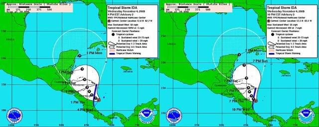
Here's the comparison of the 4PM track to the 10PM track. Clearly nudging it to the right. BTW, that last position update doesn't look very smooth in terms of the whole path, does it? That tells us that there's a trough coming into the Gulf that can't be well timed yet.
Last edited by ozonepete on Wed Nov 04, 2009 9:58 pm, edited 1 time in total.
0 likes
-
gatorcane

- S2K Supporter
- Posts: 23708
- Age: 48
- Joined: Sun Mar 13, 2005 3:54 pm
- Location: Boca Raton, FL
Interesting that that last discussion did not mention the GFDL at all in the intensity discussion. I guess they would want to see some more runs of the GFDL first.
Last edited by gatorcane on Wed Nov 04, 2009 9:59 pm, edited 2 times in total.
0 likes
Who is online
Users browsing this forum: No registered users and 75 guests