Panhandle is too far north and will have the high shear overhead.
ATL : TROPICAL DEPRESSION IDA
Moderator: S2k Moderators
-
gatorcane

- S2K Supporter

- Posts: 23708
- Age: 48
- Joined: Sun Mar 13, 2005 3:54 pm
- Location: Boca Raton, FL
Panhandle is too far north and will have the high shear overhead.
Last edited by gatorcane on Wed Nov 04, 2009 11:25 pm, edited 1 time in total.
0 likes

-
ozonepete
- Professional-Met

- Posts: 4743
- Joined: Mon Sep 07, 2009 3:23 pm
- Location: From Ozone Park, NYC / Now in Brooklyn, NY
Re: ATL : TROPICAL STORM IDA
Kludge wrote:If you're reading this thread with any thoughts about a November tropical storm strike on the US coast, then you have earned an "F" on your climatology course for this simester. El Nino is playing with your mind. You're bored ...so this looks fascinating.
And yes, I'm here posting... so I'm guilty on all counts. But it was fun to get a spike at the end of the season...
See you in '10.
You spelled "semester" wrong. Keep hitting the books.
0 likes

Re: ATL : TROPICAL STORM IDA
Ida is a small storm, so it would not surprise me if it becomes a hurricane. The last time we had an El Nino season in 2006, no storms formed in November, let alone in October. More reason to say never say never.
0 likes
-
cycloneye

- Admin

- Posts: 149744
- Age: 69
- Joined: Thu Oct 10, 2002 10:54 am
- Location: San Juan, Puerto Rico
Re: ATL : TROPICAL STORM IDA
Ok,before the thread converts into a personal chat room,I say,lets stay on the topic of Ida,thank you.
0 likes
Visit the Caribbean-Central America Weather Thread where you can find at first post web cams,radars
and observations from Caribbean basin members Click Here
and observations from Caribbean basin members Click Here
-
ozonepete
- Professional-Met
- Posts: 4743
- Joined: Mon Sep 07, 2009 3:23 pm
- Location: From Ozone Park, NYC / Now in Brooklyn, NY
Re: ATL : TROPICAL STORM IDA
cycloneye wrote:Ok,before the thread converts into a personal chat room,I say,lets stay on the topic of Ida,thank you.
Thanks, cycloneye. Sorry.
0 likes
-
HurricaneBill
- Category 5

- Posts: 3419
- Joined: Sun Apr 11, 2004 5:51 pm
- Location: East Longmeadow, MA, USA
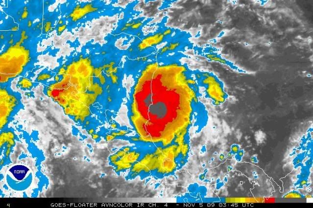
Re:
HURAKAN wrote:
Ida means business
Is that an eye or an island in the center of the darkest convection?
0 likes
-
Tampa Bay Hurricane

- Category 5
- Posts: 5597
- Age: 38
- Joined: Fri Jul 22, 2005 7:54 pm
- Location: St. Petersburg, FL
Re: ATL : TROPICAL STORM IDA
ozonepete wrote:Kludge wrote:If you're reading this thread with any thoughts about a November tropical storm strike on the US coast, then you have earned an "F" on your climatology course for this simester. El Nino is playing with your mind. You're bored ...so this looks fascinating.
And yes, I'm here posting... so I'm guilty on all counts. But it was fun to get a spike at the end of the season...
See you in '10.
You spelled "semester" wrong. Keep hitting the books.
That's the problem with age. I hit the books so hard that my fingers became flatttened, and my keystrokes became skewed. Stand by... it might happen to you.
Don't get me wrong... I wi$hcast that Ida will come up towards the CONUS with low winds and gentle rains, as an interesting anomaly. Just wanting to be pragmatic is all...
0 likes
-
ozonepete
- Professional-Met
- Posts: 4743
- Joined: Mon Sep 07, 2009 3:23 pm
- Location: From Ozone Park, NYC / Now in Brooklyn, NY
Re: ATL : TROPICAL STORM IDA
Kludge wrote:ozonepete wrote:Kludge wrote:If you're reading this thread with any thoughts about a November tropical storm strike on the US coast, then you have earned an "F" on your climatology course for this simester. El Nino is playing with your mind. You're bored ...so this looks fascinating.
0 likes
-
cycloneye
- Admin
- Posts: 149744
- Age: 69
- Joined: Thu Oct 10, 2002 10:54 am
- Location: San Juan, Puerto Rico
Re: ATL : TROPICAL STORM IDA
Kludge wrote:ozonepete wrote:Kludge wrote:If you're reading this thread with any thoughts about a November tropical storm strike on the US coast, then you have earned an "F" on your climatology course for this simester. El Nino is playing with your mind. You're bored ...so this looks fascinating.
And yes, I'm here posting... so I'm guilty on all counts. But it was fun to get a spike at the end of the season...
See you in '10.
You spelled "semester" wrong. Keep hitting the books.
That's the problem with age. I hit the books so hard that my fingers became flatttened, and my keystrokes became skewed. Stand by... it might happen to you.
Don't get me wrong... I wi$hcast that Ida will come up towards the CONUS with low winds and gentle rains, as an interesting anomaly. Just wanting to be pragmatic is all...
Please for the second time stop.Lets go to the topic in hand.
0 likes
Visit the Caribbean-Central America Weather Thread where you can find at first post web cams,radars
and observations from Caribbean basin members Click Here
and observations from Caribbean basin members Click Here
-
ozonepete
- Professional-Met
- Posts: 4743
- Joined: Mon Sep 07, 2009 3:23 pm
- Location: From Ozone Park, NYC / Now in Brooklyn, NY
Re: ATL : TROPICAL STORM IDA
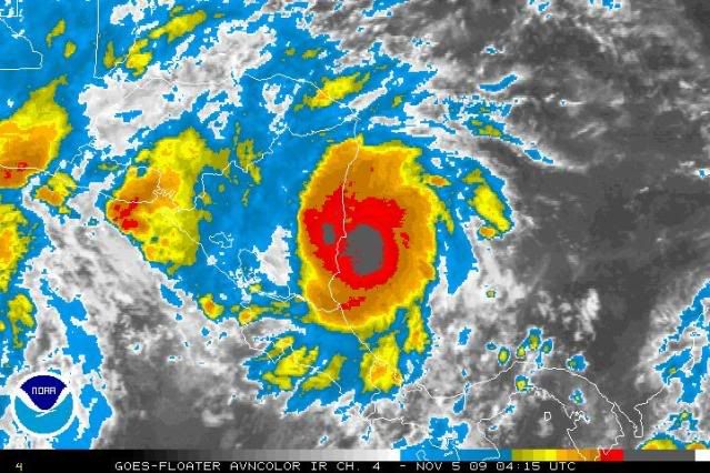
Very close to shore now. But still elongated south to north. The track forecast is really challenging and really interesting.
0 likes
-
ozonepete
- Professional-Met
- Posts: 4743
- Joined: Mon Sep 07, 2009 3:23 pm
- Location: From Ozone Park, NYC / Now in Brooklyn, NY
Re: ATL : TROPICAL STORM IDA
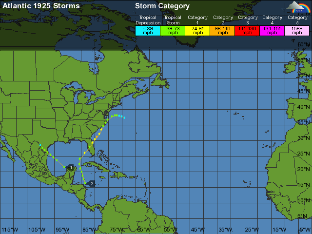
BTW, I think the track from WU above is right, but I believe it was the fourth storm, not the second. Anyway, here are the coordinates of that late November-early December hurricane that went up the U.S. east coast in 1925:
Hurricane 4 (11/27 - 12/05)
1925 Storm Archive — Current Tropical Activity
Click the map below to change the zoom level.
Tracking Map
Date: Time: Lat: Lon: Wind(mph): Pressure: Storm Type:
11/27 00 GMT 20.2 85.9 35 0 Tropical Depression
11/27 06 GMT 20.1 85.8 35 0 Tropical Depression
11/27 12 GMT 20.0 85.7 40 0 Tropical Storm
11/27 18 GMT 19.9 85.6 40 0 Tropical Storm
11/28 00 GMT 19.8 85.4 40 0 Tropical Storm
11/28 06 GMT 19.7 85.2 40 0 Tropical Storm
11/28 12 GMT 19.5 85.0 40 0 Tropical Storm
11/28 18 GMT 19.3 84.7 40 0 Tropical Storm
11/29 00 GMT 19.1 84.2 40 0 Tropical Storm
11/29 06 GMT 19.0 83.7 40 0 Tropical Storm
11/29 12 GMT 19.0 83.5 40 0 Tropical Storm
11/29 18 GMT 19.3 83.7 40 0 Tropical Storm
11/30 00 GMT 19.9 84.1 40 0 Tropical Storm
11/30 06 GMT 20.8 84.6 45 0 Tropical Storm
11/30 12 GMT 22.0 84.7 50 0 Tropical Storm
11/30 18 GMT 23.7 84.3 60 0 Tropical Storm
12/01 00 GMT 25.5 83.0 75 0 Category 1 Hurricane
12/01 06 GMT 27.5 81.5 70 0 Extratropical Storm
12/01 12 GMT 29.0 80.5 75 0 Extratropical Storm
12/01 18 GMT 30.0 79.5 85 0 Extratropical Storm
12/02 00 GMT 31.0 78.7 90 0 Extratropical Storm
12/02 06 GMT 32.0 78.1 85 0 Extratropical Storm
12/02 12 GMT 33.3 77.5 80 0 Extratropical Storm
12/02 18 GMT 34.4 76.9 75 980 Extratropical Storm
12/03 00 GMT 35.5 76.2 70 0 Extratropical Storm
12/03 06 GMT 36.5 75.4 70 0 Extratropical Storm
12/03 12 GMT 37.2 74.5 65 0 Extratropical Storm
12/03 18 GMT 37.7 73.5 65 0 Extratropical Storm
12/04 00 GMT 37.9 72.4 60 0 Extratropical Storm
12/04 06 GMT 37.8 71.2 60 0 Extratropical Storm
12/04 12 GMT 37.6 70.0 50 0 Extratropical Storm
12/04 18 GMT 37.2 69.0 50 0 Extratropical Storm
12/05 00 GMT 36.8 68.2 45 0 Extratropical Storm
12/05 06 GMT 36.4 67.7 40 0 Extratropical Storm
12/05 12 GMT 36.0 67.5 35 0 Extratropical Storm
0 likes


-
cycloneye
- Admin
- Posts: 149744
- Age: 69
- Joined: Thu Oct 10, 2002 10:54 am
- Location: San Juan, Puerto Rico
Re: ATL : TROPICAL STORM IDA
boca wrote:It doesn't look like Ida is moving at all.
Agree.If is moving,its doing it like crawling like zig-zag.
0 likes
Visit the Caribbean-Central America Weather Thread where you can find at first post web cams,radars
and observations from Caribbean basin members Click Here
and observations from Caribbean basin members Click Here
Re: ATL : TROPICAL STORM IDA
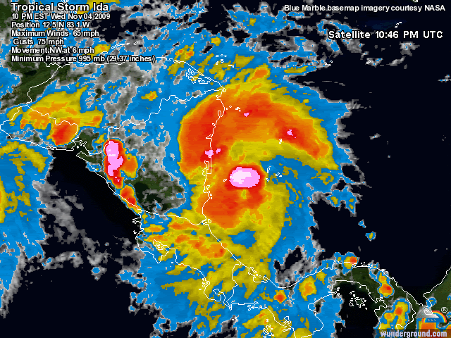
If Ida moves this slow over land it will most likely be a goner.I read in another form that JB thinks that Ida will stay off shore. I disagree with that.With the high over the Central Caribbean it should move NW inland,but because of the forward speed I'll be surprised if it survives.
0 likes
-
cycloneye
- Admin
- Posts: 149744
- Age: 69
- Joined: Thu Oct 10, 2002 10:54 am
- Location: San Juan, Puerto Rico
Re: ATL : TROPICAL STORM IDA - Models
00z GFDL mantains Ida away from land.Ends run at the western tip of Cuba.Cat 5 again as it had at the 18z run? Find out shortly.
WHXX04 KWBC 050520
CHGQLM
ATTENTION...NATIONAL HURRICANE CENTER
NCEP COUPLED GFDL HURRICANE MODEL FORECAST MADE FOR
TROPICAL STORM IDA 11L
INITIAL TIME 0Z NOV 5
DISCLAIMER ... THIS INFORMATION IS PROVIDED AS GUIDANCE. IT
REQUIRES INTERPRETATION BY HURRICANE SPECIALISTS AND SHOULD
NOT BE CONSIDERED AS A FINAL PRODUCT. PLEASE SEE THE TPC/NHC
OFFICIAL FORECAST.
FORECAST STORM POSITION
HOUR LATITUDE LONGITUDE HEADING/SPEED(KT)
0 12.3 82.8 315./ 6.0
6 12.1 82.8 176./ 1.4
12 12.5 82.5 38./ 4.9
18 13.1 82.5 0./ 5.8
24 13.4 82.7 328./ 3.2
30 13.8 82.6 11./ 3.8
36 14.0 82.3 54./ 4.0
42 14.5 82.3 0./ 5.5
48 15.1 81.9 33./ 6.7
54 15.7 81.9 6./ 6.1
60 16.3 81.7 15./ 6.1
66 16.8 81.6 8./ 4.9
72 17.3 81.8 343./ 5.6
78 17.7 82.2 317./ 5.3
84 18.1 82.4 333./ 4.2
90 19.0 82.8 334./ 9.8
96 19.3 83.2 307./ 5.0
102 20.1 83.6 334./ 8.5
108 20.7 84.1 320./ 7.8
114 21.2 84.4 330./ 6.3
120 21.9 84.7 341./ 6.9
126 22.5 84.9 336./ 6.4
0 likes
Visit the Caribbean-Central America Weather Thread where you can find at first post web cams,radars
and observations from Caribbean basin members Click Here
and observations from Caribbean basin members Click Here
Who is online
Users browsing this forum: No registered users and 68 guests