ATL : TROPICAL DEPRESSION IDA
Moderator: S2k Moderators
-
AdamFirst

- S2K Supporter

- Posts: 2490
- Age: 36
- Joined: Thu Aug 14, 2008 10:54 am
- Location: Port Saint Lucie, FL
Re: ATL : TROPICAL STORM IDA
Looks like it's hugging the coast like in the GFDL model run.
0 likes
Dolphins Marlins Canes Golden Panthers HEAT
Andrew 1992 - Irene 1999 - Frances 2004 - Jeanne 2004 - Wilma 2005 - Fay 2008 - Isaac 2012 - Matthew 2016 - Irma 2017 - Dorian 2019 - Ian 2022 - Nicole 2022 - Milton 2024
Andrew 1992 - Irene 1999 - Frances 2004 - Jeanne 2004 - Wilma 2005 - Fay 2008 - Isaac 2012 - Matthew 2016 - Irma 2017 - Dorian 2019 - Ian 2022 - Nicole 2022 - Milton 2024
-
ozonepete
- Professional-Met

- Posts: 4743
- Joined: Mon Sep 07, 2009 3:23 pm
- Location: From Ozone Park, NYC / Now in Brooklyn, NY
Re: ATL : TROPICAL STORM IDA
PTrackerLA wrote:It could be a dry slot but it gives the illusion that the LLC is trying to move more inland while the convection is spread more North.
Just the center showing up because convection is decreasing rapidly due to friction. There is little to no shear so there shouldn't be any decoupling.
0 likes
-
cycloneye

- Admin

- Posts: 149755
- Age: 69
- Joined: Thu Oct 10, 2002 10:54 am
- Location: San Juan, Puerto Rico
Re: ATL : TROPICAL STORM IDA
ozonepete,is it moving 320 degrees as the latest bams have or is going more than that?
0 likes
Visit the Caribbean-Central America Weather Thread where you can find at first post web cams,radars
and observations from Caribbean basin members Click Here
and observations from Caribbean basin members Click Here

Re: ATL : TROPICAL STORM IDA - Models
The 12Z GFS and NOGAPs are strange runs in that they stall the system in the GOM and move it south and southwest. I think its more likely looking at the dynamical models and climatology that Ida will simply turn NE, start to accerlerate, and transition to a extratropical cyclone ahead of the massive high building down from the central US.
0 likes
-
Bocadude85

- Category 5

- Posts: 2991
- Age: 39
- Joined: Mon Apr 18, 2005 2:20 pm
- Location: Honolulu,Hi
Re: ATL : TROPICAL STORM IDA
tolakram wrote:Goes data selector link
http://wwwghcc.msfc.nasa.gov/cgi-bin/ge ... mframes=10Code: Select all
http://wwwghcc.msfc.nasa.gov/cgi-bin/get-goes?satellite=GOES-E%20HURRICANE&lat=15&lon=-85&info=vis&zoom=1&width=3000&height=2000&type=Animation&numframes=10
Looks to be weakening fairly rapidly.
0 likes

-
vbhoutex

- Storm2k Executive
- Posts: 29150
- Age: 74
- Joined: Wed Oct 09, 2002 11:31 pm
- Location: Cypress, TX
- Contact:
Re: ATL : TROPICAL STORM IDA
I'm on a comp away from the house so I don't have as many resources available, but it sure looks to me like Ida is stalled and/or moving more W at this time. If this continues(and actually is happening) it will be hard for Ida to survive her trip across Nicaragua if she even makes it out of Nicaragua. Of course the big problem with this scenario is the increaed probability of flooding rains and landslides. JMHO
0 likes
Skywarn, C.E.R.T.
Please click below to donate to STORM2K to help with the expenses of keeping the site going:

Please click below to donate to STORM2K to help with the expenses of keeping the site going:
-
CourierPR

- Category 5
- Posts: 1336
- Age: 72
- Joined: Tue Aug 31, 2004 7:53 pm
- Location: Pompano Beach, Florida
Re: ATL : TROPICAL STORM IDA
The circulation pattern appears to be lifting north, so I don't think its moving west.
0 likes
-
cycloneye
- Admin
- Posts: 149755
- Age: 69
- Joined: Thu Oct 10, 2002 10:54 am
- Location: San Juan, Puerto Rico
Re: ATL : TROPICAL STORM IDA
For the members who may not know the directions in numbers,here is a graphic and the numbers.
http://climate.umn.edu/snow_fence/Compo ... table3.htm

http://climate.umn.edu/snow_fence/Compo ... table3.htm
Code: Select all
Cardinal Direction Degree Direction

N
 348.75 - 11.25

NNE
 11.25 - 33.75

NE
 33.75 - 56.25

ENE
 56.25 - 78.75

E
 78.75 - 101.25

ESE
 101.25 - 123.75

SE
 123.75 - 146.25

SSE
 146.25 - 168.75

S
 168.75 - 191.25

SSW
 191.25 - 213.75

SW
 213.75 - 236.25

WSW
 236.25 - 258.75

W
 258.75 - 281.25

WNW
 281.25 - 303.75

NW
 303.75 - 326.25

NNW
 326.25 - 348.75
0 likes
Visit the Caribbean-Central America Weather Thread where you can find at first post web cams,radars
and observations from Caribbean basin members Click Here
and observations from Caribbean basin members Click Here
-
ozonepete
- Professional-Met
- Posts: 4743
- Joined: Mon Sep 07, 2009 3:23 pm
- Location: From Ozone Park, NYC / Now in Brooklyn, NY
Re: ATL : TROPICAL STORM IDA
cycloneye wrote:ozonepete,is it moving 320 degrees as the latest bams have or is going more than that?
I was just trying to get a fix and that's exactly what it looks like right now - 320 degrees. I thought it might be more northerly but it's not from what I can tell. Also, it's getting easier to track now because the waning convection has caused enough high clouds to clear that we can see the center.
It also looks like it's moving along now, i.e. it's no longer stationary.
Last edited by ozonepete on Thu Nov 05, 2009 3:20 pm, edited 1 time in total.
0 likes
-
cycloneye
- Admin
- Posts: 149755
- Age: 69
- Joined: Thu Oct 10, 2002 10:54 am
- Location: San Juan, Puerto Rico
Re: ATL : TROPICAL STORM IDA
It also looks like it's moving along now.
Means less time over land.
0 likes
Visit the Caribbean-Central America Weather Thread where you can find at first post web cams,radars
and observations from Caribbean basin members Click Here
and observations from Caribbean basin members Click Here
-
AJC3

- Admin
- Posts: 4156
- Age: 62
- Joined: Tue Aug 31, 2004 7:04 pm
- Location: Ballston Spa, New York
- Contact:
Re: ATL : TROPICAL STORM IDA - Models
ronjon wrote:The 12Z GFS and NOGAPs are strange runs in that they stall the system in the GOM and move it south and southwest. I think its more likely looking at the dynamical models and climatology that Ida will simply turn NE, start to accerlerate, and transition to a extratropical cyclone ahead of the massive high building down from the central US.
I think what solutions such as these are showing (or at the very least implying) is that there is the possibility of conditions becoming so hostile west of Florida as to decapitate the system, leaving a remnant low level circulation behind to drift toward the southwest (or thereabouts) steered by the large surface-H85 ridge to the north. When you think about it, it's not all that strange or far-fetched.
0 likes
-
ozonepete
- Professional-Met
- Posts: 4743
- Joined: Mon Sep 07, 2009 3:23 pm
- Location: From Ozone Park, NYC / Now in Brooklyn, NY
Re: ATL : TROPICAL STORM IDA
cycloneye wrote:It also looks like it's moving along now.
Means less time over land.
Right. I'm also in the camp that thinks this will survive the overland trip, as long as it stays on or near the NHC track. As Jeff MAsters noted, 5 of the 6 storms in the past that took a similar track over Nicaragua survived and intensified. That's pretty good odds. And this one had, and still has, very good structure. Since friction, at first, only kills the core of winds at the surface, and there's no mountains there, the MLC can survive quite a while. And this MLC looks to be surviving fine for now. We will see.
0 likes

Re: ATL : TROPICAL STORM IDA - Models
deltadog03 wrote:As much as I hate to say it, I think the euro is on crack. Its trying to split out all that energy btwn IDA and the thing in the SW gom right now. I don't see that happening, but it is the euro.
it is the EURO and when it latches on to a certain scenario I am hugging it.
0 likes
Re: ATL : TROPICAL STORM IDA - Models
AJC3 wrote:ronjon wrote:The 12Z GFS and NOGAPs are strange runs in that they stall the system in the GOM and move it south and southwest. I think its more likely looking at the dynamical models and climatology that Ida will simply turn NE, start to accerlerate, and transition to a extratropical cyclone ahead of the massive high building down from the central US.
I think what solutions such as these are showing (or at the very least implying) is that there is the possibility of conditions becoming so hostile west of Florida as to decapitate the system, leaving a remnant low level circulation behind to drift toward the southwest (or thereabouts) steered by the large surface-H85 ridge to the north. When you think about it, it's not all that strange or far-fetched.
I totally agreement with this scenario....
0 likes


-
wxman57

- Moderator-Pro Met

- Posts: 23175
- Age: 68
- Joined: Sat Jun 21, 2003 8:06 pm
- Location: Houston, TX (southwest)
Re: ATL : TROPICAL STORM IDA
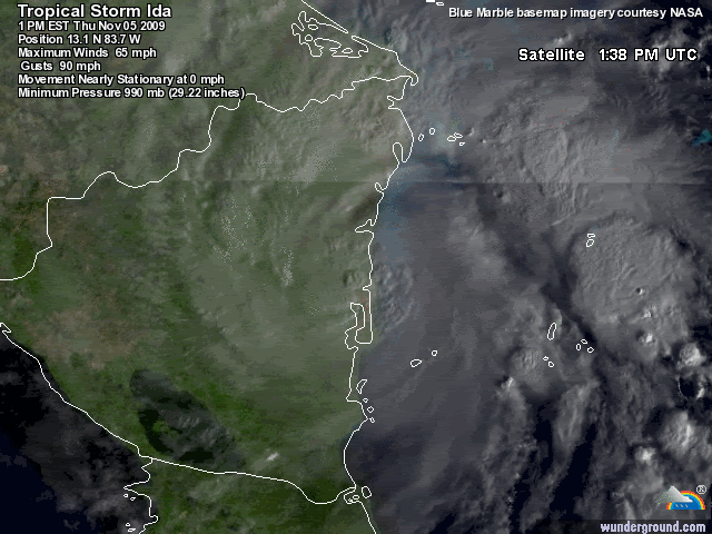
I can't see any NW movement on a 5-hr satellite loop. Center COULD be a little west of the heavier convection near 13.3N/84W. If that's it, it's moving nearly due north (very short term movement). Certainly appears to be weakening rapidly. Have a few observation sites on the coast of Nicaragua. One 70 miles north and one 70 miles south of the storm. Both reporting 15kts or less. So Ida still has a tiny wind field.
I think it'll survive the interaction with land. My track takes it toward Tampa bay Wednesday evening. In most cases like this, though, the storm tracks right of the forecast. Latest GFDL points it toward the SW FL peninsula with that NE hook at the end. I don't see it tracking NE right after passing Honduras as the GFDL forecasts, though.
I think it'll survive the interaction with land. My track takes it toward Tampa bay Wednesday evening. In most cases like this, though, the storm tracks right of the forecast. Latest GFDL points it toward the SW FL peninsula with that NE hook at the end. I don't see it tracking NE right after passing Honduras as the GFDL forecasts, though.
0 likes
Re: ATL : TROPICAL STORM IDA
wxman57 wrote:I can't see any NW movement on a 5-hr satellite loop. Center COULD be a little west of the heavier convection near 13.3N/84W. If that's it, it's moving nearly due north (very short term movement). Certainly appears to be weakening rapidly. Have a few observation sites on the coast of Nicaragua. One 70 miles north and one 70 miles south of the storm. Both reporting 15kts or less. So Ida still has a tiny wind field.
I think it'll survive the interaction with land. My track takes it toward Tampa bay Wednesday evening. In most cases like this, though, the storm tracks right of the forecast. Latest GFDL points it toward the SW FL peninsula with that NE hook at the end. I don't see it tracking NE right after passing Honduras as the GFDL forecasts, though.
What about the EURO that are looking eerily similar run after run yesterday and today? Conditions in the GOM will be highly unfavorable aloft...
0 likes

I totally agree I think this will end up quite a bit further east then most models are suggesting past 72-96hrs, GFDL doesn't look that bad bar as you say the NE jog.
As for the system, that dry slot really is making inroads so weakening is surely happening, probably down to about 55mph now I'd suspect.
As for the system, that dry slot really is making inroads so weakening is surely happening, probably down to about 55mph now I'd suspect.
0 likes
Personal Forecast Disclaimer:
The posts in this forum are NOT official forecast and should not be used as such. They are just the opinion of the poster and may or may not be backed by sound meteorological data. They are NOT endorsed by any professional institution or storm2k.org. For official information, please refer to the NHC and NWS products
The posts in this forum are NOT official forecast and should not be used as such. They are just the opinion of the poster and may or may not be backed by sound meteorological data. They are NOT endorsed by any professional institution or storm2k.org. For official information, please refer to the NHC and NWS products
-
cycloneye
- Admin
- Posts: 149755
- Age: 69
- Joined: Thu Oct 10, 2002 10:54 am
- Location: San Juan, Puerto Rico
Re: ATL : TROPICAL STORM IDA - Advisories
000
WTNT31 KNHC 052038
TCPAT1
BULLETIN
TROPICAL STORM IDA ADVISORY NUMBER 6
NWS TPC/NATIONAL HURRICANE CENTER MIAMI FL AL112009
400 PM EST THU NOV 05 2009
...IDA CONTINUES TO WEAKEN...HEAVY RAINFALL STILL THE PRIMARY
CONCERN...
A TROPICAL STORM WARNING REMAINS IN EFFECT FOR THE EAST COAST OF
NICARAGUA FROM BLUEFIELDS NORTHWARD TO THE HONDURAS/NICARAGUA
BORDER.
AT 4 PM EST...2100 UTC...THE GOVERNMENT OF HONDURAS HAS ISSUED A
TROPICAL STORM WATCH FOR THE NORTHEAST COAST OF HONDURAS FROM LIMON
EASTWARD TO THE HONDURAS/NICARAGUA BORDER. A TROPICAL STORM WATCH
MEANS THAT TROPICAL STORM CONDITIONS ARE POSSIBLE WITHIN THE WATCH
AREA...GENERALLY WITHIN 36 HOURS.
INTERESTS ELSEWHERE IN HONDURAS SHOULD MONITOR THE PROGRESS OF IDA.
FOR STORM INFORMATION SPECIFIC TO YOUR AREA...PLEASE MONITOR
PRODUCTS ISSUED BY YOUR NATIONAL METEOROLOGICAL SERVICE.
AT 400 PM EST...2100 UTC...THE CENTER OF TROPICAL STORM IDA WAS
LOCATED NEAR LATITUDE 13.3 NORTH...LONGITUDE 83.7 WEST OR ABOUT 50
MILES... 85 KM...SOUTH-SOUTHWEST OF PUERTO CABEZAS NICARAGUA AND
ABOUT 90 MILES...145 KM...NORTH OF BLUEFIELDS NICARAGUA.
IDA IS MOVING TOWARD THE NORTH-NORTHWEST NEAR 3 MPH...6 KM/HR. A
TURN TOWARD THE NORTH AT A SLIGHTLY FASTER FORWARD SPEED IS EXPECTED
TONIGHT OR FRIDAY. ON THE FORECAST TRACK...THE CENTER OF IDA WILL
MOVE ACROSS NORTHEASTERN NICARAGUA AND EASTERN HONDURAS DURING THE
NEXT DAY OR SO. THE TROPICAL CYCLONE IS FORECAST TO EMERGE OVER
THE NORTHWESTERN CARIBBEAN SEA EARLY SATURDAY.
MAXIMUM SUSTAINED WINDS HAVE DECREASED TO NEAR 60 MPH...95
KM/HR...WITH HIGHER GUSTS. ADDITIONAL WEAKENING IS EXPECTED AND
IDA IS FORECAST TO WEAKEN TO A TROPICAL DEPRESSION ON FRIDAY. SOME
RESTRENGTHENING IS POSSIBLE AFTER IDA EMERGES OVER THE NORTHWESTERN
CARIBBEAN SEA ON SATURDAY.
TROPICAL STORM FORCE WINDS EXTEND OUTWARD UP TO 70 MILES...110 KM
FROM THE CENTER.
ESTIMATED MINIMUM CENTRAL PRESSURE IS 990 MB...29.23 INCHES.
IDA IS EXPECTED TO PRODUCE TOTAL RAINFALL ACCUMULATIONS OF 5 TO 7
INCHES ALONG THE COASTS OF EASTERN HONDURAS AND NICARAGUA...AND THE
ISLANDS OFF THE COAST OF NICARAGUA WITH MAXIMUM AMOUNTS OF 12
INCHES POSSIBLE. MAXIMUM RAINFALL ACCUMULATIONS OF 15 TO 20 INCHES
ARE POSSIBLE OVER REGIONS OF ELEVATED TERRAIN IN HONDURAS AND
NICARAGUA. THESE RAINS COULD PRODUCE LIFE-THREATENING FLASH FLOODS
AND MUD SLIDES.
HIGHER-THAN-NORMAL WATER LEVELS ALONG PORTIONS OF THE EAST COAST OF
NICARAGUA SHOULD CONTINUE TO DECREASE TONIGHT.
...SUMMARY OF 400 PM EST INFORMATION...
LOCATION...13.3N 83.7W
MAXIMUM SUSTAINED WINDS...60 MPH
PRESENT MOVEMENT...NORTH-NORTHWEST OR 330 DEGREES AT 3 MPH
MINIMUM CENTRAL PRESSURE...990 MB
AN INTERMEDIATE ADVISORY WILL BE ISSUED BY THE NATIONAL HURRICANE
CENTER AT 700 PM EST FOLLOWED BY THE NEXT COMPLETE ADVISORY AT 1000
PM EST.
$$
FORECASTER BROWN/BLAKE
TROPICAL STORM IDA DISCUSSION NUMBER 6
NWS TPC/NATIONAL HURRICANE CENTER MIAMI FL AL112009
400 PM EST THU NOV 05 2009
THE SATELLITE PRESENTATION OF IDA HAS GRADUALLY DEGRADED SINCE IT
MADE LANDFALL THIS MORNING...AND THE INITIAL INTENSITY HAS BEEN
LOWERED TO 50 KT.
IDA APPEARS TO HAVE SLOWED AND TURNED MORE NORTH-NORTHWESTWARD WITH
AN INITIAL MOTION ESTIMATE OF 330/3. THE FORECAST REASONING HAS
NOT CHANGED SINCE THIS MORNING AND THE TRACK GUIDANCE REMAINS IN
REASONABLY GOOD AGREEMENT ON A NORTH-NORTHWESTWARD TO NORTHWARD
MOTION DURING THE NEXT COUPLE DAYS. THE GUIDANCE HAS SHIFTED A
LITTLE EASTWARD AND IS A LITTLE FASTER DURING THE FIRST 48 HOURS.
AFTER THAT...THE MODELS SHOW A GENERAL NORTH-NORTHWESTWARD TRACK
INTO THE SOUTHERN GULF OF MEXICO. THERE REMAINS A LARGE SPREAD IN
THE GUIDANCE AFTER 72 HOURS. THE GFDL AND GFS ARE ALONG THE EASTERN
SIDE OF THE GUIDANCE ENVELOPE...WHILE THE NOGAPS IS ALONG THE
WESTERN EDGE. THE OFFICIAL FORECAST IS NEAR THE MIDDLE THE
ENVELOPE...BUT REMAINS A LITTLE SLOWER THAN THE MODEL CONSENSUS.
IDA SHOULD CONTINUE TO WEAKEN AS IT MOVES OVER NORTHEASTERN
NICARAGUA AND EASTERN HONDURAS DURING THE NEXT DAY OR SO. SOME
RESTRENGTHENING IS FORECAST AFTER THE CENTER EMERGES INTO THE
NORTHWEST CARIBBEAN SEA. HOWEVER...CONDITIONS DO NOT APPEAR TO BE
EXTREMELY FAVORABLE FOR INTENSIFICATION AS UPPER-LEVEL SOUTHWESTERLY
WINDS ARE EXPECTED TO PRODUCE MODERATE SHEAR OVER THE SYSTEM.
LATER IN THE PERIOD WESTERLY WINDS BECOME QUITE STRONG AND SHOULD
ARREST FURTHER STRENGTHENING. THERE REMAINS A LARGE DEGREE OF
UNCERTAINTY IN THE LONGER-RANGE FORECAST...SINCE IDA MAY NOT
SURVIVE ITS PASSAGE OVER LAND.
THE BIGGEST IMPACT OF THIS SLOW-MOVING SYSTEM DURING THE NEXT COUPLE
OF DAYS WILL LIKELY BE LIFE-THREATENING FLASH FLOODS AND MUD SLIDES
CAUSED BY EXTREMELY HEAVY RAIN OVER PORTIONS OF NICARAGUA AND
HONDURAS.
FORECAST POSITIONS AND MAX WINDS
INITIAL 05/2100Z 13.3N 83.7W 50 KT
12HR VT 06/0600Z 13.9N 83.9W 40 KT...INLAND
24HR VT 06/1800Z 14.9N 84.1W 30 KT...INLAND
36HR VT 07/0600Z 16.0N 84.3W 35 KT...OVER WATER
48HR VT 07/1800Z 17.1N 84.6W 40 KT
72HR VT 08/1800Z 19.6N 85.7W 45 KT
96HR VT 09/1800Z 22.5N 87.0W 45 KT
120HR VT 10/1800Z 25.0N 87.0W 45 KT
$$
FORECASTER BROWN
0 likes
Visit the Caribbean-Central America Weather Thread where you can find at first post web cams,radars
and observations from Caribbean basin members Click Here
and observations from Caribbean basin members Click Here
Who is online
Users browsing this forum: No registered users and 75 guests