ATL : TROPICAL DEPRESSION IDA

Moderator: S2k Moderators

Message
Author
User avatar
HURAKAN
Professional-Met
Professional-Met
Posts: 46086
Age: 38
Joined: Thu May 20, 2004 4:34 pm
Location: Key West, FL
Contact:

Re: ATL : TROPICAL STORM IDA

#821 Postby HURAKAN » Thu Nov 05, 2009 8:46 pm

Bocadude85 wrote:Im not sure that there will be much left of Ida once she emerges into the Gulf of Honduras


Loop: http://rammb.cira.colostate.edu/ramsdis ... _floater_2

The structure still looks good
0 likes   

Dean4Storms
S2K Supporter
S2K Supporter
Posts: 6358
Age: 62
Joined: Sun Aug 31, 2003 1:01 pm
Location: Miramar Bch. FL

#822 Postby Dean4Storms » Thu Nov 05, 2009 8:48 pm

Do the GFDL or HWRF take SST's into account in their solutions?
0 likes   

RideMass
Tropical Wave
Tropical Wave
Posts: 2
Joined: Thu Nov 05, 2009 8:23 pm

Re: ATL : TROPICAL STORM IDA

#823 Postby RideMass » Thu Nov 05, 2009 8:48 pm

Hey guys,

Long time lurker first time poster. These storms have really interested me since I was young and I am glad I stumbled into this site while following the unfortunate onslaught of Typhoons in the Philippines. Anyways, I will be eager to follow this storm and hope to learn a lot from the many knowledgeable people this site seems to have.
0 likes   

User avatar
gone2beach
S2K Supporter
S2K Supporter
Posts: 70
Joined: Wed Aug 27, 2008 1:20 pm
Location: Long Beach, MS

#824 Postby gone2beach » Thu Nov 05, 2009 8:50 pm

Prediction for overnight low here is 48*, and the water felt pretty darned cool tonight, too...didn't have a thermometer with me to check the acutal temp.
0 likes   

Dean4Storms
S2K Supporter
S2K Supporter
Posts: 6358
Age: 62
Joined: Sun Aug 31, 2003 1:01 pm
Location: Miramar Bch. FL

#825 Postby Dean4Storms » Thu Nov 05, 2009 8:53 pm

Ida should have plenty of structure left once she re-emerges back into the Carib. and with low shear and high SST's still in place she should ramp back up fairly quickly IMO. Also, with her hugging the coast and staying out of the mountains her LLC should still be present albeit much weaker.
0 likes   

User avatar
jdray
Category 3
Category 3
Posts: 853
Joined: Tue Aug 31, 2004 10:07 pm
Location: NE Florida

Re: ATL : TROPICAL STORM IDA - Models

#826 Postby jdray » Thu Nov 05, 2009 8:54 pm

Ivanhater wrote:18z HWRf aiming for central Florida Panhandle

Image


Thats more the big bend area, nice NE movement at the end of that model.
The models are seeing a front moving in (normal this time of year) so that if Ida survives and grows, wherever she makes it into the GOM, those E and NE of her should keep an eye out.
0 likes   

User avatar
Evil Jeremy
S2K Supporter
S2K Supporter
Posts: 5463
Age: 32
Joined: Mon Apr 10, 2006 2:10 pm
Location: Los Angeles, CA

#827 Postby Evil Jeremy » Thu Nov 05, 2009 8:55 pm

Convection continues to fire on the northern side of the LCC. This new convection burst, however small, might be able to keep this as a TS through the next advisory. Not to mention the fact that the storm still appears to be well organized.

http://www.ssd.noaa.gov/goes/flt/t2/loop-wv.html
0 likes   
Frances 04 / Jeanne 04 / Katrina 05 / Wilma 05 / Fay 08 / Debby 12 / Andrea 13 / Colin 16 / Hermine 16 / Matthew 16 / Irma 17

User avatar
cycloneye
Admin
Admin
Posts: 145332
Age: 68
Joined: Thu Oct 10, 2002 10:54 am
Location: San Juan, Puerto Rico

Re: ATL : TROPICAL STORM IDA

#828 Postby cycloneye » Thu Nov 05, 2009 9:00 pm

RideMass wrote:Hey guys,

Long time lurker first time poster. These storms have really interested me since I was young and I am glad I stumbled into this site while following the unfortunate onslaught of Typhoons in the Philippines. Anyways, I will be eager to follow this storm and hope to learn a lot from the many knowledgeable people this site seems to have.


Welcome to storm2k.Great to have another new member of the growing number of Phillipine friends on the site.We look forward to your participation.
0 likes   
Visit the Caribbean-Central America Weather Thread where you can find at first post web cams,radars
and observations from Caribbean basin members Click Here

RideMass
Tropical Wave
Tropical Wave
Posts: 2
Joined: Thu Nov 05, 2009 8:23 pm

Re: ATL : TROPICAL STORM IDA

#829 Postby RideMass » Thu Nov 05, 2009 9:10 pm

cycloneye wrote:
RideMass wrote:Hey guys,

Long time lurker first time poster. These storms have really interested me since I was young and I am glad I stumbled into this site while following the unfortunate onslaught of Typhoons in the Philippines. Anyways, I will be eager to follow this storm and hope to learn a lot from the many knowledgeable people this site seems to have.


Welcome to storm2k.Great to have another new member of the growing number of Phillipine friends on the site.We look forward to your participation.


Thanks for the welcome, though not from the Philippines, born and raised in Massachusetts. Obviously I haven't experienced tropical storms too often, but my interest grew in them after taking a few college Meteorology courses. Seems like i found a good place as there is a ton of information on this site. :D
0 likes   

ozonepete
Professional-Met
Professional-Met
Posts: 4743
Joined: Mon Sep 07, 2009 3:23 pm
Location: From Ozone Park, NYC / Now in Brooklyn, NY

Re: ATL : TROPICAL STORM IDA

#830 Postby ozonepete » Thu Nov 05, 2009 9:26 pm

dolebot_Broward_NW wrote:
convection has been refiring north of the LCC for the past couple of hours.


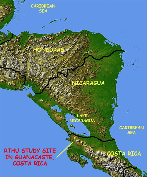
I wonder how much of that is orographically enhanced: I know the atlantic side is mostly plains, but where she seems to be firing is in the mildly high mountains in the center of the country.

Image


That has to be mostly orographic lifting. As the warm humid air coming from the east and northeast pushes up against the mountains it has nowhere to go but up. The moisture in the rising air condenses into big thunderstorms.

Sorry I missed part of your post. You were right to think it's orographic.
Last edited by ozonepete on Thu Nov 05, 2009 9:31 pm, edited 1 time in total.
0 likes   

ozonepete
Professional-Met
Professional-Met
Posts: 4743
Joined: Mon Sep 07, 2009 3:23 pm
Location: From Ozone Park, NYC / Now in Brooklyn, NY

Re: ATL : TROPICAL STORM IDA

#831 Postby ozonepete » Thu Nov 05, 2009 9:28 pm

RideMass wrote:Hey guys,

Long time lurker first time poster. These storms have really interested me since I was young and I am glad I stumbled into this site while following the unfortunate onslaught of Typhoons in the Philippines. Anyways, I will be eager to follow this storm and hope to learn a lot from the many knowledgeable people this site seems to have.


Welcome!
0 likes   

User avatar
Ivanhater
Storm2k Moderator
Storm2k Moderator
Posts: 11161
Age: 38
Joined: Fri Jul 01, 2005 8:25 am
Location: Pensacola

Re: ATL : TROPICAL STORM IDA - Models

#832 Postby Ivanhater » Thu Nov 05, 2009 9:33 pm

Image
0 likes   
Michael

ozonepete
Professional-Met
Professional-Met
Posts: 4743
Joined: Mon Sep 07, 2009 3:23 pm
Location: From Ozone Park, NYC / Now in Brooklyn, NY

Re: ATL : TROPICAL STORM IDA

#833 Postby ozonepete » Thu Nov 05, 2009 9:36 pm

I guess we all have the suspicion that the NHC will nudge the immediate track a little further east again.
0 likes   

User avatar
cycloneye
Admin
Admin
Posts: 145332
Age: 68
Joined: Thu Oct 10, 2002 10:54 am
Location: San Juan, Puerto Rico

Re: ATL : TROPICAL DEPRESSION IDA - Advisories

#834 Postby cycloneye » Thu Nov 05, 2009 9:39 pm

000
WTNT31 KNHC 060236
TCPAT1
BULLETIN
TROPICAL DEPRESSION IDA ADVISORY NUMBER 7
NWS TPC/NATIONAL HURRICANE CENTER MIAMI FL AL112009
1000 PM EST THU NOV 05 2009

...IDA WEAKENS TO A DEPRESSION...FLOOD THREAT CONTINUES...

AT 1000 PM EST...0300 UTC...THE GOVERNMENT OF NICARAGUA HAS
DISCONTINUED THE TROPICAL STORM WARNING FOR THE EAST COAST OF
NICARAGUA FROM BLUEFIELDS NORTHWARD TO THE HONDURAS/NICARAGUA
BORDER.

A TROPICAL STORM WATCH IS IN EFFECT FOR THE NORTHEAST COAST OF
HONDURAS FROM LIMON EASTWARD TO THE HONDURAS/NICARAGUA BORDER. A
TROPICAL STORM WATCH MEANS THAT TROPICAL STORM CONDITIONS ARE
POSSIBLE WITHIN THE WATCH AREA...GENERALLY WITHIN 36 HOURS.

INTERESTS ELSEWHERE IN HONDURAS SHOULD MONITOR THE PROGRESS OF IDA.

FOR STORM INFORMATION SPECIFIC TO YOUR AREA...PLEASE MONITOR
PRODUCTS ISSUED BY YOUR NATIONAL METEOROLOGICAL SERVICE.

AT 1000 PM EST...0300 UTC...THE CENTER OF TROPICAL DEPRESSION IDA
WAS LOCATED NEAR LATITUDE 13.8 NORTH...LONGITUDE 84.1 WEST OR ABOUT
50 MILES... 80 KM...WEST-SOUTHWEST OF PUERTO CABEZAS NICARAGUA.

THE DEPRESSION IS MOVING TOWARD THE NORTH-NORTHWEST NEAR 5 MPH. A
TURN TOWARD THE NORTH AT A SLIGHTLY FASTER FORWARD SPEED IS EXPECTED
ON FRIDAY. ON THE FORECAST TRACK...THE CENTER OF IDA WILL MOVE
ACROSS NORTHEASTERN NICARAGUA AND EASTERN HONDURAS DURING THE
NEXT DAY OR SO. THE TROPICAL CYCLONE IS FORECAST TO EMERGE OVER
THE NORTHWESTERN CARIBBEAN SEA EARLY SATURDAY.

MAXIMUM SUSTAINED WINDS HAVE DECREASED TO NEAR 35 MPH...55
KM/HR...WITH HIGHER GUSTS. ADDITIONAL WEAKENING IS EXPECTED
TONIGHT AND FRIDAY AS IDA MOVES OVER LAND. SOME RESTRENGTHENING IS
LIKELY AFTER IDA EMERGES OVER THE NORTHWESTERN CARIBBEAN SEA ON
SATURDAY.

ESTIMATED MINIMUM CENTRAL PRESSURE IS 1004 MB...29.65 INCHES.

IDA IS EXPECTED TO PRODUCE TOTAL RAINFALL ACCUMULATIONS OF 5 TO 7
INCHES ALONG THE COASTS OF EASTERN HONDURAS AND NICARAGUA...AND THE
ISLANDS OFF THE COAST OF NICARAGUA WITH MAXIMUM AMOUNTS OF 12
INCHES POSSIBLE. MAXIMUM RAINFALL ACCUMULATIONS OF 15 TO 20 INCHES
ARE POSSIBLE OVER REGIONS OF ELEVATED TERRAIN IN HONDURAS AND
NICARAGUA. THESE RAINS COULD PRODUCE LIFE-THREATENING FLASH FLOODS
AND MUD SLIDES.

...SUMMARY OF 1000 PM EST INFORMATION...
LOCATION...13.8N 84.1W
MAXIMUM SUSTAINED WINDS...35 MPH
PRESENT MOVEMENT...NORTH-NORTHWEST OR 330 DEGREES AT 5 MPH
MINIMUM CENTRAL PRESSURE...1004 MB

AN INTERMEDIATE ADVISORY WILL BE ISSUED BY THE NATIONAL HURRICANE
CENTER AT 100 AM EST FOLLOWED BY THE NEXT COMPLETE ADVISORY AT 400
AM EST.

$$
FORECASTER PASCH/ROBERTS

000
WTNT41 KNHC 060241
TCDAT1
TROPICAL DEPRESSION IDA DISCUSSION NUMBER 7
NWS TPC/NATIONAL HURRICANE CENTER MIAMI FL AL112009
1000 PM EST THU NOV 05 2009

SURFACE OBSERVATIONS AND CONVENTIONAL SATELLITE IMAGERY INDICATE
THAT IDA HAS WEAKENED TO A TROPICAL DEPRESSION. WHAT REMAINS OF THE
DIMINISHING DEEP CONVECTION IS CURRENTLY CONFINED TO NORTHWEST AND
NORTHEAST QUADRANTS. SOME FURTHER WEAKENING IS LIKELY DURING THE
NEXT 12 TO 24 HOURS AS IDA CONTINUES ON A GENERAL NORTHWARD TRACK
OVER NORTHEASTERN NICARAGUA AND EASTERN HONDURAS. AROUND THE 36
HOUR PERIOD...THE CYCLONE SHOULD EMERGE OVER THE NORTHWEST
CARIBBEAN SEA AND...ASSUMING THE CIRCULATION IS NOT TOO SEVERELY
DISRUPTED BY ITS PASSAGE OVER LAND...THE SYSTEM SHOULD RESTRENGTHEN
INTO A TROPICAL STORM. HOWEVER...THE GLOBAL MODELS INDICATE ONLY A
MARGINALLY FAVORABLE UPPER-LEVEL WIND ENVIRONMENT OVER THE
REGION...WHICH SHOULD CURTAIL SIGNIFICANT INTENSIFICATION AS IDA
HEADS IN THE GENERAL DIRECTION OF THE YUCATAN CHANNEL. AFTER IDA
ENTERS THE SOUTHERN GULF OF MEXICO....THE INTENSITY FORECAST IS
HIGHLY UNCERTAIN. THE LARGE-SCALE MODELS ALL AGREE ON AN
INCREASINGLY STRONG VERTICAL SHEAR ENVIRONMENT DEVELOPING OVER THE
GULF OF MEXICO TOWARD THE END OF THE FORECAST PERIOD. THE GFDL AND
HWRF MODELS...PARTICULARLY THE FORMER...SHOW SIGNIFICANT
INTENSIFICATION OF IDA IN THE LATTER PART OF THE PERIOD. IT SHOULD
BE RECALLED HOWEVER THAT THESE MODELS HAVE BEEN KNOWN TO HAVE A
HIGH BIAS IN STRONGLY SHEARED ENVIRONMENTS...AS WAS THE CASE WITH
TROPICAL STORMS DANNY...ERIKA...AND HENRI OF THIS YEAR.
CONSEQUENTLY...THE OFFICIAL WIND SPEED FORECAST LEANS MORE TOWARD
THE WEAKER LGEM AND SHIPS PREDICTIONS.

THE INITIAL MOTION IS ESTIMATED TO BE 330/4...WITHIN THE SOUTHERLY
STEERING FLOW ON THE WEST SIDE OF A WEAK MID-LEVEL RIDGE. WITH THE
EXCEPTION OF FORWARD SPEED DISPARITIES...THE GLOBAL AND REGIONAL
MODELS CONTINUE TO INDICATE A GENERAL NORTH TO NORTH-NORTHWESTWARD
MOTION INTO THE CENTRAL GULF OF MEXICO OVER THE NEXT 4 DAYS.
AROUND THE END OF THE PERIOD...MOST OF THE TRACK GUIDANCE SHOWS A
TURN TO THE RIGHT AS IDA BEGINS TO INTERACT WITH THE WESTERLIES.
THE OFFICIAL FORECAST HAS CHANGED LITTLE FROM THE PREVIOUS ONE AND
IS CLOSE TO THE MODEL CONSENSUS.

THE BIGGEST IMPACT OF THIS SLOW-MOVING SYSTEM DURING THE NEXT DAY OR
SO WILL LIKELY BE LIFE-THREATENING FLASH FLOODS AND MUD SLIDES
CAUSED BY EXTREMELY HEAVY RAIN OVER PORTIONS OF NICARAGUA AND
HONDURAS.

FORECAST POSITIONS AND MAX WINDS

INITIAL 06/0300Z 13.8N 84.1W 30 KT
12HR VT 06/1200Z 14.4N 84.1W 25 KT...INLAND
24HR VT 07/0000Z 15.4N 84.2W 25 KT...INLAND
36HR VT 07/1200Z 16.6N 84.5W 35 KT...OVER WATER
48HR VT 08/0000Z 17.7N 85.0W 40 KT
72HR VT 09/0000Z 20.3N 86.2W 45 KT
96HR VT 10/0000Z 23.0N 87.5W 45 KT
120HR VT 11/0000Z 26.0N 87.0W 45 KT

$$
FORECASTER PASCH/ROBERTS


0 likes   
Visit the Caribbean-Central America Weather Thread where you can find at first post web cams,radars
and observations from Caribbean basin members Click Here

User avatar
cycloneye
Admin
Admin
Posts: 145332
Age: 68
Joined: Thu Oct 10, 2002 10:54 am
Location: San Juan, Puerto Rico

Re: ATL : TROPICAL DEPRESSION IDA

#835 Postby cycloneye » Thu Nov 05, 2009 9:40 pm

...SUMMARY OF 1000 PM EST INFORMATION...
LOCATION...13.8N 84.1W
MAXIMUM SUSTAINED WINDS...35 MPH
PRESENT MOVEMENT...NORTH-NORTHWEST OR 330 DEGREES AT 5 MPH
MINIMUM CENTRAL PRESSURE...1004 MB
0 likes   
Visit the Caribbean-Central America Weather Thread where you can find at first post web cams,radars
and observations from Caribbean basin members Click Here

User avatar
gatorcane
S2K Supporter
S2K Supporter
Posts: 23691
Age: 47
Joined: Sun Mar 13, 2005 3:54 pm
Location: Boca Raton, FL

#836 Postby gatorcane » Thu Nov 05, 2009 9:41 pm

From the 10PM EST advisory. I think there is little debate on this. It is going to restrengthen when it gets back over water. Question is how much not if

SOME RESTRENGTHENING IS
LIKELY AFTER IDA EMERGES OVER THE NORTHWESTERN CARIBBEAN SEA ON
SATURDAY.
0 likes   

User avatar
Macrocane
Category 5
Category 5
Posts: 4218
Age: 36
Joined: Sun May 24, 2009 5:35 pm
Location: El Salvador

Re: ATL : TROPICAL STORM IDA

#837 Postby Macrocane » Thu Nov 05, 2009 9:43 pm

El Salvador government declared "green alert" this morning due to the influence of Ida and the disturbance on EPAC. The national meteorological agency is forecasting that 96-E will come closer to Guatemala/El Salvador coasts and with the possible re-strengthening of Ida heavy rains are expected, both systems will help to place the ITCZ just off our coast so we'll have a lot of moisture entering from the Pacific, this type of scenarios are usual on september and october but not in november. Yesterday here in the city where I live the accumulated precipitation was about 30 mm (1.2 inches) and the highest accumaltion in the country was 62 mm (2.44 inches), the forecasters are expecting ammounts of 100 mm on saturday (4 inches) and that could produce landslides and flooding. Right now we've experiencing moderate rainfall and if you look at IR convection is not strong, that's typicall in this cases, convection doen't need to be strong to produce precipitation.
0 likes   

User avatar
cycloneye
Admin
Admin
Posts: 145332
Age: 68
Joined: Thu Oct 10, 2002 10:54 am
Location: San Juan, Puerto Rico

Re: ATL : TROPICAL DEPRESSION IDA

#838 Postby cycloneye » Thu Nov 05, 2009 9:44 pm

Image
0 likes   
Visit the Caribbean-Central America Weather Thread where you can find at first post web cams,radars
and observations from Caribbean basin members Click Here

User avatar
CourierPR
Category 5
Category 5
Posts: 1335
Age: 71
Joined: Tue Aug 31, 2004 7:53 pm
Location: Pompano Beach, Florida

Re: ATL : TROPICAL STORM IDA

#839 Postby CourierPR » Thu Nov 05, 2009 9:45 pm

ozonepete wrote:I guess we all have the suspicion that the NHC will nudge the immediate track a little further east again.

According to what I see on satellite, there appears to be a more northerly component to Ida's track. If this continues, I would think the NHC would adjust the track.
0 likes   

User avatar
Evil Jeremy
S2K Supporter
S2K Supporter
Posts: 5463
Age: 32
Joined: Mon Apr 10, 2006 2:10 pm
Location: Los Angeles, CA

#840 Postby Evil Jeremy » Thu Nov 05, 2009 9:49 pm

The NHC now forecasts Ida to move back open water possibility late tomorrow night rather than on Saturday. That seems more likely as Ida continues to head north, faster than previously expected (though still slowly).
0 likes   
Frances 04 / Jeanne 04 / Katrina 05 / Wilma 05 / Fay 08 / Debby 12 / Andrea 13 / Colin 16 / Hermine 16 / Matthew 16 / Irma 17


Return to “2009”

Who is online

Users browsing this forum: No registered users and 11 guests