ATL : TROPICAL DEPRESSION IDA
Moderator: S2k Moderators

Re: ATL : TROPICAL DEPRESSION IDA
She's down (to a td) but not out. And it does seem that she could be back over water before tomorrow morning. But isn't there a possibility of shear when it emerges over water, so full regeneration might not happen, hm.
0 likes
-
cycloneye

- Admin

- Posts: 149760
- Age: 69
- Joined: Thu Oct 10, 2002 10:54 am
- Location: San Juan, Puerto Rico
Re: ATL : TROPICAL DEPRESSION IDA - Models
06z HWRF has a cat 2 in the NW Caribbean,but weakens it to a strong tropical storm in the SE GOM.
http://moe.met.fsu.edu/cgi-bin/hwrftc2. ... =Animation
06z GFDL is a little more realistic with the intensity as it does not bomb to a cat 5,but still is high as it goes to a high end cat 2.
http://moe.met.fsu.edu/cgi-bin/gfdltc2. ... =Animation
http://moe.met.fsu.edu/cgi-bin/hwrftc2. ... =Animation
06z GFDL is a little more realistic with the intensity as it does not bomb to a cat 5,but still is high as it goes to a high end cat 2.
http://moe.met.fsu.edu/cgi-bin/gfdltc2. ... =Animation
0 likes
Visit the Caribbean-Central America Weather Thread where you can find at first post web cams,radars
and observations from Caribbean basin members Click Here
and observations from Caribbean basin members Click Here
-
CourierPR

- Category 5

- Posts: 1336
- Age: 72
- Joined: Tue Aug 31, 2004 7:53 pm
- Location: Pompano Beach, Florida
Re: ATL : TROPICAL DEPRESSION IDA
Ida appears as if her circulation will be over water a lot sooner than previously forecasted. I don't think we'll have to wait until tomorrow morning. I also think regeneration will occur- to what magnitude remains uncertain.
0 likes
-
cycloneye
- Admin
- Posts: 149760
- Age: 69
- Joined: Thu Oct 10, 2002 10:54 am
- Location: San Juan, Puerto Rico
Re: ATL : TROPICAL DEPRESSION IDA - Advisories
000
WTNT31 KNHC 061148
TCPAT1
BULLETIN
TROPICAL DEPRESSION IDA INTERMEDIATE ADVISORY NUMBER 8A
NWS TPC/NATIONAL HURRICANE CENTER MIAMI FL AL112009
700 AM EST FRI NOV 06 2009
...IDA APPROACHING THE HONDURAS/NICARAGUA BORDER...
A TROPICAL STORM WATCH IS IN EFFECT FOR THE NORTHEAST COAST OF
HONDURAS FROM LIMON EASTWARD TO THE HONDURAS/NICARAGUA BORDER. A
TROPICAL STORM WATCH MEANS THAT TROPICAL STORM CONDITIONS ARE
POSSIBLE WITHIN THE WATCH AREA...GENERALLY WITHIN 36 HOURS.
INTERESTS ELSEWHERE IN HONDURAS SHOULD MONITOR THE PROGRESS OF IDA.
FOR STORM INFORMATION SPECIFIC TO YOUR AREA...PLEASE MONITOR
PRODUCTS ISSUED BY YOUR NATIONAL METEOROLOGICAL SERVICE.
AT 700 AM EST...1200 UTC...THE CENTER OF TROPICAL DEPRESSION IDA WAS
LOCATED NEAR LATITUDE 14.6 NORTH...LONGITUDE 84.2 WEST OR ABOUT 65
MILES...105 KM...WEST-SOUTHWEST OF CABO GRACIAS A DIOS ON THE
NICARAGUA/HONDURAS BORDER.
THE DEPRESSION IS MOVING TOWARD THE NORTH NEAR 6 MPH...10 KM/HR.
THIS GENERAL MOTION IS EXPECTED TO CONTINUE WITH A SLIGHT INCREASE
IN FORWARD SPEED OVER THE NEXT COUPLE OF DAYS. ON THE FORECAST
TRACK...THE CENTER OF IDA WILL MOVE ACROSS EASTERN HONDURAS TODAY
AND EMERGE OVER THE NORTHWESTERN CARIBBEAN SEA TONIGHT OR EARLY
SATURDAY.
MAXIMUM SUSTAINED WINDS REMAIN NEAR 35 MPH...55 KM/HR...WITH HIGHER
GUSTS. SOME ADDITIONAL WEAKENING IS POSSIBLE TODAY AS THE CENTER OF
IDA REMAINS OVER LAND. SOME RESTRENGTHENING IS LIKELY AFTER IDA
EMERGES OVER THE NORTHWESTERN CARIBBEAN SEA TONIGHT OR EARLY
SATURDAY.
THE ESTIMATED MINIMUM CENTRAL PRESSURE IS 1005 MB...29.68 INCHES.
IDA IS EXPECTED TO PRODUCE TOTAL RAINFALL ACCUMULATIONS OF 5 TO 7
INCHES ALONG THE COASTS OF EASTERN HONDURAS AND NICARAGUA...AND THE
ISLANDS OFF THE COAST OF NICARAGUA WITH MAXIMUM AMOUNTS OF 12
INCHES POSSIBLE. MAXIMUM RAINFALL ACCUMULATIONS OF 15 TO 20 INCHES
ARE POSSIBLE OVER REGIONS OF ELEVATED TERRAIN IN HONDURAS AND
NICARAGUA. THESE RAINS COULD PRODUCE LIFE-THREATENING FLASH FLOODS
AND MUD SLIDES.
...SUMMARY OF 700 AM EST INFORMATION...
LOCATION...14.6N 84.2W
MAXIMUM SUSTAINED WINDS...35 MPH
PRESENT MOVEMENT...NORTH OR 350 DEGREES AT 6 MPH
MINIMUM CENTRAL PRESSURE...1005 MB
THE NEXT ADVISORY WILL BE ISSUED BY THE NATIONAL HURRICANE CENTER AT
1000 AM EST.
$$
FORECASTER CANGIALOSI/BRENNAN/BLAKE
0 likes
Visit the Caribbean-Central America Weather Thread where you can find at first post web cams,radars
and observations from Caribbean basin members Click Here
and observations from Caribbean basin members Click Here
-
cycloneye
- Admin
- Posts: 149760
- Age: 69
- Joined: Thu Oct 10, 2002 10:54 am
- Location: San Juan, Puerto Rico
Re: ATL : TROPICAL DEPRESSION IDA
...SUMMARY OF 700 AM EST INFORMATION...
LOCATION...14.6N 84.2W
MAXIMUM SUSTAINED WINDS...35 MPH
PRESENT MOVEMENT...NORTH OR 350 DEGREES AT 6 MPH
MINIMUM CENTRAL PRESSURE...1005 MB
LOCATION...14.6N 84.2W
MAXIMUM SUSTAINED WINDS...35 MPH
PRESENT MOVEMENT...NORTH OR 350 DEGREES AT 6 MPH
MINIMUM CENTRAL PRESSURE...1005 MB
0 likes
Visit the Caribbean-Central America Weather Thread where you can find at first post web cams,radars
and observations from Caribbean basin members Click Here
and observations from Caribbean basin members Click Here


-
cycloneye
- Admin
- Posts: 149760
- Age: 69
- Joined: Thu Oct 10, 2002 10:54 am
- Location: San Juan, Puerto Rico
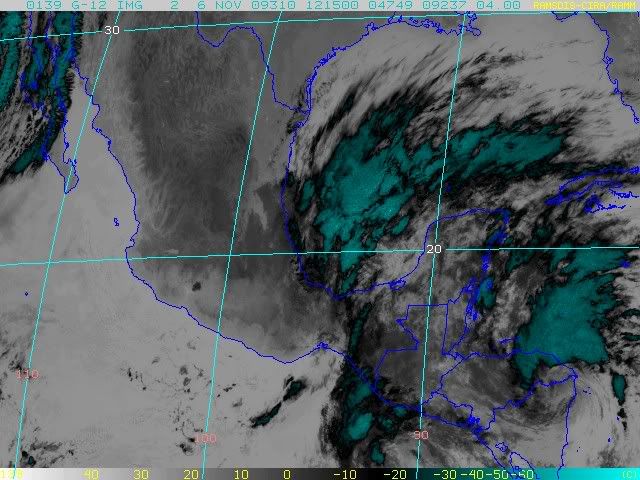
Re: ATL : TROPICAL DEPRESSION IDA
Strong low level convergence.

0 likes
Visit the Caribbean-Central America Weather Thread where you can find at first post web cams,radars
and observations from Caribbean basin members Click Here
and observations from Caribbean basin members Click Here
-
cycloneye
- Admin
- Posts: 149760
- Age: 69
- Joined: Thu Oct 10, 2002 10:54 am
- Location: San Juan, Puerto Rico
Re:
artist wrote:abyone have the latest euro?
The 00z EURO doesnt show a bonifide TC but some energy in the GOM.
http://www.ecmwf.int/products/forecasts ... 00!!!step/
0 likes
Visit the Caribbean-Central America Weather Thread where you can find at first post web cams,radars
and observations from Caribbean basin members Click Here
and observations from Caribbean basin members Click Here


-
cycloneye
- Admin
- Posts: 149760
- Age: 69
- Joined: Thu Oct 10, 2002 10:54 am
- Location: San Juan, Puerto Rico
Re: ATL : TROPICAL DEPRESSION IDA
From the Melbourne NWS discussion.I found it interesting as it talks about all the players involved.
http://www.srh.noaa.gov/productview.php ... MLB&max=31
EXTENDED...ALL EYES WILL BE ON IDA AS SHE IS EXPECTED TO EMERGE
OVER THE NORTHWESTERN CARIBBEAN SEA EARLY SAT WITH SOME
RESTRENGTHENING POSSIBLE ACCORDING TO CURRENT THINKING. GIVEN THE
DEGREE OF UNCERTAINTY WITH IDA AS SHE MAKES HER PLAY ON THE GULF
OF MEXICO EARLY NEXT WEEK...THE LOCAL EXTENDED FORECAST IS
SOMEWHAT UP IN THE AIR. TUE MORN SHOULD FIND IDA MOVING TOWARD THE
OPEN WATERS OF THE GULF. THE GFS FAVORS A TRACK TENDENCY WHICH
APPROACHES THE FLORIDA PENINSULA DURING WED WITH A TIGHTENING
GRADIENT AND MOSITURE INCREASE OVER THE FORECAST AREA BEGINNING
TUE. THIS IS AN AGGRESSIVE SOLUTION...WHICH COULD FURTHER SUPPORT
ONGOING LOCAL MARINE HAZARDS...ALONG WITH THE THREAT OF SOME
HEAVY RAIN AND ISOLATED TORNADOES. IN CONTRAST...THIS IS NOT
EXACTLY HOW THE ECMWF SEES IT AS IT KEEPS IDA (REMNANTS/MOISTURE)
LESS ORGANIZED AND FARTHER WEST...UNTIL A SHORT WAVE SNATCHES HER
UP TO ADVECT SIGNIFICANT TROPICAL MOISTURE OVER THE REGION BY WED.
THUS...A BLENDED SOLUTION IS PREFERRED AND IS MORE IN LINE WITH
THE OFFICIAL FORECAST ANYWAY. CONSEQUENTLY...PRUDENCE DEMANDS AN
INCREASE IN RAIN CHANCES AND A SOMEWHAT STIFFENING OF THE WIND
FIELD TO SET UP THE TREND. BY WED...A FRONTAL BOUNDARY IS PROGGED
TO BE DRAPED ACROSS NORTH FLORIDA WITH BULLISH HIGH PRESSURE
OVERSPREADING THE EASTERN CONUS. THIS WILL WORK TO KEEP IDA
SHUNTED SOUTH AND FROM ACQUIRING LATITUDE. THE COMMON SENSE THEME
IS A STIFF AND CONTINUED ONSHORE FLOW.
http://www.srh.noaa.gov/productview.php ... MLB&max=31
0 likes
Visit the Caribbean-Central America Weather Thread where you can find at first post web cams,radars
and observations from Caribbean basin members Click Here
and observations from Caribbean basin members Click Here
-
O Town
- S2K Supporter

- Posts: 5205
- Age: 52
- Joined: Wed Sep 07, 2005 9:37 pm
- Location: Orlando, Florida 28°35'35"N 81°22'55"W
Re: ATL : TROPICAL DEPRESSION IDA
Here's some climatology for you guys.
All hurricanes in the month of November cat.1 or higher in the Caribbean area.

All hurricanes in the month of November cat.1 or higher in the Caribbean area.

0 likes
#ORLANDOSTRONG
-
jlauderdal
- S2K Supporter
- Posts: 7240
- Joined: Wed May 19, 2004 5:46 am
- Location: NE Fort Lauderdale
- Contact:
Re: ATL : TROPICAL DEPRESSION IDA
O Town wrote:Here's some climatology for you guys.
All hurricanes in the month of November cat.1 or higher in the Caribbean area.
the theme of that is it can go anywhere
0 likes
-
cycloneye
- Admin
- Posts: 149760
- Age: 69
- Joined: Thu Oct 10, 2002 10:54 am
- Location: San Juan, Puerto Rico
Re: ATL : TROPICAL DEPRESSION IDA - Recon
Will they fly tonight as it will emerge earlier than what they were expecting? We will find out later this morning at the plan of the day.
0 likes
Visit the Caribbean-Central America Weather Thread where you can find at first post web cams,radars
and observations from Caribbean basin members Click Here
and observations from Caribbean basin members Click Here

Re: ATL : TROPICAL DEPRESSION IDA
getting very close to be off shore.
I am really stumped as to the NHC forecast cone. With the fronts coming down now, it just doesn't make sense it would get that far north. Is it just me? I would think htey would at least lean right a little more so if this survives there can be some planning going on.

I am really stumped as to the NHC forecast cone. With the fronts coming down now, it just doesn't make sense it would get that far north. Is it just me? I would think htey would at least lean right a little more so if this survives there can be some planning going on.
0 likes
-
gatorcane

- S2K Supporter
- Posts: 23708
- Age: 48
- Joined: Sun Mar 13, 2005 3:54 pm
- Location: Boca Raton, FL
Looking at the latest 06Z model consensus the NHC cone is now to the left by day 5. I do expect the NHC to bend the 3-5 day cone more right (probably next advisory). The west coast of FL would be at the highest risk so needs close watching. But I'm hopeful shear will rip it apart before it can get to the West Coast of FL. If it makes a run anywhere further north one would think shear would get it first looking at the 200MB flow by day 5 across the Northern GOM, not to mention the SSTs are way to cool in the northern GOM to support a hurricane or even a strong tropical storm.

Last edited by gatorcane on Fri Nov 06, 2009 7:59 am, edited 1 time in total.
0 likes

Re: ATL : TROPICAL DEPRESSION IDA
Ida still looks healthy for a tropical cyclone that has been over land for 24 hours, like I said a couple of days ago, inflow from the Pacific was going to be cut but moisture from the Caribbean was going to help Ida to survive. The first visible shows a well defined circulation, naked but at least better defined than that of "Damny" ... I mean Danny 
0 likes
Re: ATL : TROPICAL DEPRESSION IDA
Macrocane wrote:Ida still looks healthy for a tropical cyclone that has been over land for 24 hours, like I said a couple of days ago, inflow from the Pacific was going to be cut but moisture from the Caribbean was going to help Ida to survive. The first visible shows a well defined circulation, naked but at least better defined than that of "Damny" ... I mean Danny
how's your rain been?
0 likes
Who is online
Users browsing this forum: No registered users and 95 guests