ATL : TROPICAL DEPRESSION IDA
Moderator: S2k Moderators
-
Weatherboy1

- Category 5

- Posts: 1190
- Age: 50
- Joined: Mon Jul 05, 2004 1:50 pm
- Location: Jupiter/Sarasota, FL
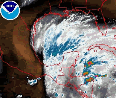
One other thing -- Ida appears to already be moving due N or perhaps even a bit E of N. Extrapolating current motion suggests this thing only has another 6-8 hours over land, which means a re-emergence into the NW Caribbean this afternoon. And that means this thing could have more time to strengthen. I still believe it will ultimately get sheared right back down to maybe a strong TS before it makes landfall (likely on the W coast of FL somewhere, in my opinion). But it's possible we could get up to Cat 1 or Cat 2 strength if she gets out over water as soon as it appears she will.
0 likes
-
Aric Dunn
- Category 5
- Posts: 21238
- Age: 43
- Joined: Sun Sep 19, 2004 9:58 pm
- Location: Ready for the Chase.
- Contact:
Considering it has a little faster motion and slightly to the right of the forecast track and that it should emerge off the coast in the next 6 hours vs. 24hrs from the last advisory. Ida will have more time under a good upper environment overnight tonight and tomorrow for some significant strengthening. this faster motion also plays a role in the long term as it will likely be at a slightly higher latitude which would allow the trough to pick it up rather than being left behind as the most of the models are hinting at. Also a stronger system would also be more likely to turn more easterly sooner which also leads to a higher chance the trough will pick it up. next thing to wait for is if this present motions continues..
0 likes

-
ozonepete
- Professional-Met

- Posts: 4743
- Joined: Mon Sep 07, 2009 3:23 pm
- Location: From Ozone Park, NYC / Now in Brooklyn, NY
Re: ATL : TROPICAL DEPRESSION IDA
The center is almost level with the 18Z forecast point and once again east of the forecast point. This will definitely be over the water by late afternoon.
0 likes
-
wxman57

- Moderator-Pro Met

- Posts: 23175
- Age: 68
- Joined: Sat Jun 21, 2003 8:06 pm
- Location: Houston, TX (southwest)
Re: ATL : TROPICAL DEPRESSION IDA
I estimate the center to be at 14.8N/84W as of 14Z. It has another 60 miles to the north before it reaches the water. Track will be right of NHC's. I still think the west-central FL Peninsula for U.S. landfall, maybe near Tampa. Probably a very sheared TS by then.
0 likes
-
gatorcane

- S2K Supporter

- Posts: 23708
- Age: 48
- Joined: Sun Mar 13, 2005 3:54 pm
- Location: Boca Raton, FL
Re: ATL : TROPICAL DEPRESSION IDA
wxman57 wrote:I estimate the center to be at 14.8N/84W as of 14Z. It has another 60 miles to the north before it reaches the water. Track will be right of NHC's. I still think the west-central FL Peninsula for U.S. landfall, maybe near Tampa. Probably a very sheared TS by then.
Agree with that forecast 100%. Also SSTs in the EGOM are not that warm really especially north of Tampa Bay's lattitude, only in the SE GOM so wouldn't expect a significant system in the EGOM.
0 likes

Yep I agree with that, I'm thinking between 50-60kts at landfall, though I actually think it will reach hurricane status again before shear starts to really ramp up.
Going to be very wet regardless in Florida whatever occurs!
Going to be very wet regardless in Florida whatever occurs!
0 likes
Personal Forecast Disclaimer:
The posts in this forum are NOT official forecast and should not be used as such. They are just the opinion of the poster and may or may not be backed by sound meteorological data. They are NOT endorsed by any professional institution or storm2k.org. For official information, please refer to the NHC and NWS products
The posts in this forum are NOT official forecast and should not be used as such. They are just the opinion of the poster and may or may not be backed by sound meteorological data. They are NOT endorsed by any professional institution or storm2k.org. For official information, please refer to the NHC and NWS products
Re: ATL : TROPICAL DEPRESSION IDA - Models
The EURO is very good at seeing the upper air pattern well in advance. This last run brings Ida's left overs into the GOM then pushes whats left SW. Sheared mess no doubt. 6z GFS showed this as well. Her LLC might get pushed SW while her moisture gets ejected over FL with the trof.
Hopefully that'll be the extent of it, but I'm getting a quesy feeling in my gizzard (perhaps it was that third chili dog - it did taste a little funny)...
LOL
P.S. Seriously, though, best to keep an eye on this (here in South Florida) just to make sure that nothing catches us off guard - my concern is that, per a couple of models earlier this morning, Ida might make a sharp right turn ahead of the trough - as a hurricane - and cross South Florida...
That would catch many people off guard...
0 likes
-
ozonepete
- Professional-Met
- Posts: 4743
- Joined: Mon Sep 07, 2009 3:23 pm
- Location: From Ozone Park, NYC / Now in Brooklyn, NY
Re: ATL : TROPICAL DEPRESSION IDA
wxman57 wrote:I estimate the center to be at 14.8N/84W as of 14Z. It has another 60 miles to the north before it reaches the water. Track will be right of NHC's. I still think the west-central FL Peninsula for U.S. landfall, maybe near Tampa. Probably a very sheared TS by then.
That's exactly where I pinned it. With 60 miles to go, the most it can take to get offshore is 10 hours so around 9PM tonight at the latest. If it's moving faster (which think it is) it will obviously be out this afternoon. At 10mph it would be out at 3PM.
Also, I still think anywhere from Pensacola to Sarasota. Too early to tell. But I am thinking a little more about Tampa now.
0 likes
-
Evil Jeremy

- S2K Supporter
- Posts: 5463
- Age: 32
- Joined: Mon Apr 10, 2006 2:10 pm
- Location: Los Angeles, CA
I think that this could regain hurricane status, especially if it comes out sooner than forecast. I think a west Florida coast landfall is very likely. I would say from Ft. Myers through the big bend area is the prime area for a direct hit from a moderate strength, but heavy rain inducing Tropical Storm.
0 likes
Frances 04 / Jeanne 04 / Katrina 05 / Wilma 05 / Fay 08 / Debby 12 / Andrea 13 / Colin 16 / Hermine 16 / Matthew 16 / Irma 17
-
AdamFirst

- S2K Supporter
- Posts: 2490
- Age: 36
- Joined: Thu Aug 14, 2008 10:54 am
- Location: Port Saint Lucie, FL
This northeast wobble is making a huge difference.
The early GFDL models have been spot on, except for intensity.
The early GFDL models have been spot on, except for intensity.
0 likes
Dolphins Marlins Canes Golden Panthers HEAT
Andrew 1992 - Irene 1999 - Frances 2004 - Jeanne 2004 - Wilma 2005 - Fay 2008 - Isaac 2012 - Matthew 2016 - Irma 2017 - Dorian 2019 - Ian 2022 - Nicole 2022 - Milton 2024
Andrew 1992 - Irene 1999 - Frances 2004 - Jeanne 2004 - Wilma 2005 - Fay 2008 - Isaac 2012 - Matthew 2016 - Irma 2017 - Dorian 2019 - Ian 2022 - Nicole 2022 - Milton 2024
-
Evil Jeremy
- S2K Supporter
- Posts: 5463
- Age: 32
- Joined: Mon Apr 10, 2006 2:10 pm
- Location: Los Angeles, CA
Re: ATL : TROPICAL DEPRESSION IDA - Models
Frank2 wrote:That would catch many people off guard...
Eh, I am sure the FL media will make sure people know waaaaaaaaaay in advance lol.
0 likes
Frances 04 / Jeanne 04 / Katrina 05 / Wilma 05 / Fay 08 / Debby 12 / Andrea 13 / Colin 16 / Hermine 16 / Matthew 16 / Irma 17
Perhaps, but with the weekend upon us and many snowbird boaters already down here for the season (also in the Keys and in Southwest Florida), that could be a real problem for many, since Ida was not even mentioned this morning (outside of the normal weather segments, due to yesterday's breaking news in Texas)...
We'll see what the 18Z model runs show, though Derek mentioned that most are now agreeing on the sheared TC scenario - we'll see...
Frank
We'll see what the 18Z model runs show, though Derek mentioned that most are now agreeing on the sheared TC scenario - we'll see...
Frank
0 likes
It'll be interesting to see whether it takes that NNW/NW bend back that the models/NHC expect, I think it won't be quite so obvious as they expect, I think only a slight bend back west before a turn to the NE. Much depends on how long it takes the core to get back, as others have said Isadore took a long while to get it back. Still I personally think this has a fair chance of making hurricane status.
0 likes
Personal Forecast Disclaimer:
The posts in this forum are NOT official forecast and should not be used as such. They are just the opinion of the poster and may or may not be backed by sound meteorological data. They are NOT endorsed by any professional institution or storm2k.org. For official information, please refer to the NHC and NWS products
The posts in this forum are NOT official forecast and should not be used as such. They are just the opinion of the poster and may or may not be backed by sound meteorological data. They are NOT endorsed by any professional institution or storm2k.org. For official information, please refer to the NHC and NWS products
Something to watch Frank, as others have said with these sorts of set-ups the models tend to be too far west and the system ends up being further east then expected.
0 likes
Personal Forecast Disclaimer:
The posts in this forum are NOT official forecast and should not be used as such. They are just the opinion of the poster and may or may not be backed by sound meteorological data. They are NOT endorsed by any professional institution or storm2k.org. For official information, please refer to the NHC and NWS products
The posts in this forum are NOT official forecast and should not be used as such. They are just the opinion of the poster and may or may not be backed by sound meteorological data. They are NOT endorsed by any professional institution or storm2k.org. For official information, please refer to the NHC and NWS products
-
gatorcane
- S2K Supporter
- Posts: 23708
- Age: 48
- Joined: Sun Mar 13, 2005 3:54 pm
- Location: Boca Raton, FL
Re:
Frank2 wrote:Perhaps, but with the weekend upon us and many snowbird boaters already down here for the season (also in the Keys and in Southwest Florida), that could be a real problem for many, since Ida was not even mentioned this morning (outside of the normal weather segments, due to yesterday's breaking news in Texas)...
We'll see what the 18Z model runs show, though Derek mentioned that most are now agreeing on the sheared TC scenario - we'll see...
Frank
Well we'll see what the models do but hopefully it will just be a sheared mess towards peninsula florida.
0 likes
-
tolakram
- Admin

- Posts: 20187
- Age: 62
- Joined: Sun Aug 27, 2006 8:23 pm
- Location: Florence, KY (name is Mark)
Re: ATL : TROPICAL DEPRESSION IDA
http://wwwghcc.msfc.nasa.gov/cgi-bin/ge ... mframes=10
Code: Select all
http://wwwghcc.msfc.nasa.gov/cgi-bin/get-goes?satellite=GOES-E%20HURRICANE&lat=17&lon=-85&info=vis&zoom=1&width=3000&height=2000&type=Animation&numframes=10
0 likes
M a r k
- - - - -
Join us in chat: Storm2K Chatroom Invite. Android and IOS apps also available.
The posts in this forum are NOT official forecasts and should not be used as such. Posts are NOT endorsed by any professional institution or STORM2K.org. For official information and forecasts, please refer to NHC and NWS products.
-
brunota2003

- S2K Supporter
- Posts: 9476
- Age: 35
- Joined: Sat Jul 30, 2005 9:56 pm
- Location: Stanton, KY...formerly Havelock, NC
- Contact:
-
wxman57
- Moderator-Pro Met
- Posts: 23175
- Age: 68
- Joined: Sat Jun 21, 2003 8:06 pm
- Location: Houston, TX (southwest)
Re: ATL : TROPICAL DEPRESSION IDA
ozonepete wrote:... snip...
Also, I still think anywhere from Pensacola to Sarasota. Too early to tell. But I am thinking a little more about Tampa now.
It would have to cross the jet core to hit Pensacola, so probably not that far west.
0 likes
Who is online
Users browsing this forum: No registered users and 74 guests