ATL : TROPICAL DEPRESSION IDA
Moderator: S2k Moderators
-
Aric Dunn
- Category 5

- Posts: 21238
- Age: 43
- Joined: Sun Sep 19, 2004 9:58 pm
- Location: Ready for the Chase.
- Contact:
Re:
gatorcane wrote:the latest shear map may be decreasing but it looks like shear is increasing some over Ida to me. What does everybody think?
if you toggle the the images between the last few back and forth you can see the southern edge of the 15kts retreating north ever so slightly every 3 hours.
0 likes
Re: ATL : TROPICAL DEPRESSION IDA - Models
Thanks Jay, good to see you around. 
In regards to my previous post on the Euro.... to add:
CMC is doing the same thing...
http://www.meteo.psu.edu/~gadomski/CMCT ... cloop.html
So is the NOGAPS..
http://www.meteo.psu.edu/~gadomski/NGPT ... sloop.html
GFS and UKmet are more on the north and then loop back south track.
It is really clear that the truth is going to show in the next 24hrs on whether or not IDA crosses over to the Yucatan "at it's base" to join the other disturbance..... We will see i guess... I don't see it happening right now.
0 likes
-
Derek Ortt
-
Aric Dunn
- Category 5

- Posts: 21238
- Age: 43
- Joined: Sun Sep 19, 2004 9:58 pm
- Location: Ready for the Chase.
- Contact:
Re:
Derek Ortt wrote:I actually see an anti-cyclone building over Ida, albeit a very small one
The main problem with the convection at the present time is that the southern side has downslope flow off of the mountains. This may need to get 100 miles into the Carib before this really takes off
yeah it needs to get a little farther away for sure.. but the signs are already starting ..
0 likes
Re: ATL : TROPICAL DEPRESSION IDA - Models
Per the HPC, apparently the Euro has been persistent in this Bay of Campeche low and there exists some evidence supporting this model. If the Bay of Campeche low develops, though, I'd lean towards anticipating Ida to shear-out owing to the non-tropical low's dominance. The models might be merging the two systems and showing (perhaps correctly) a hybrid scenario unfolding. Though, still, I am skeptical of some of the intensities I'm seeing.
- Jay
South Florida
- Jay
South Florida
0 likes
- cycloneye
- Admin

- Posts: 149225
- Age: 69
- Joined: Thu Oct 10, 2002 10:54 am
- Location: San Juan, Puerto Rico
Re: ATL : TROPICAL DEPRESSION IDA
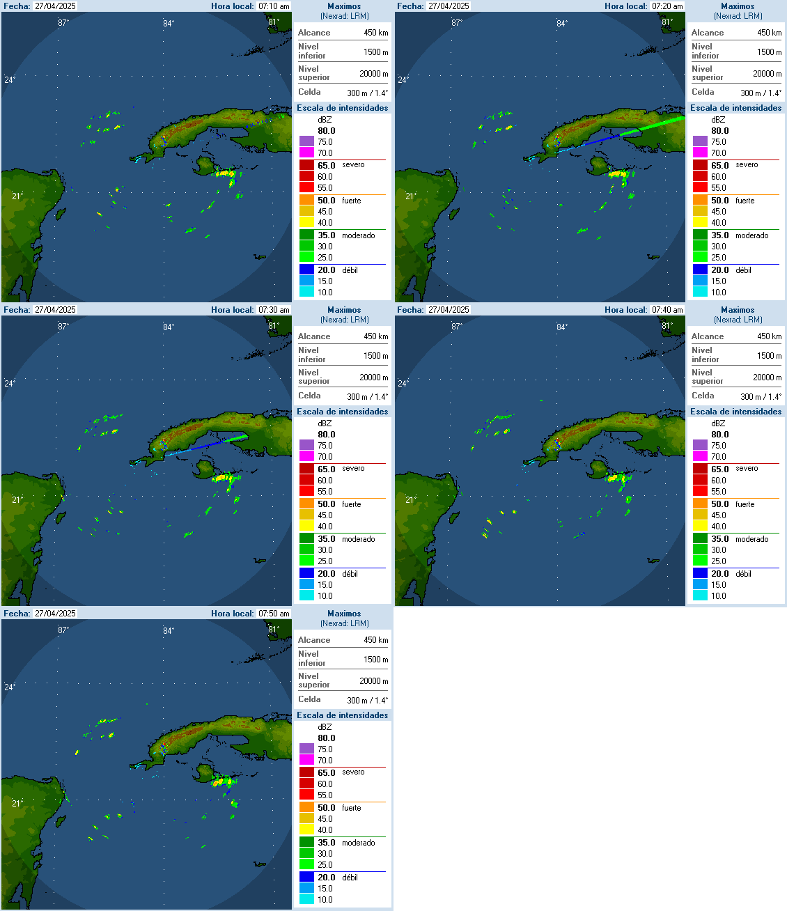
Aric mentioned Cuban Radars and here is one of them with base in the most Western part of that country that for sure will be very helpful in the comming days.
Link to radars site.
http://www.insmet.cu/asp/genesis.asp?TB ... B1=RADARES

Link to radars site.
http://www.insmet.cu/asp/genesis.asp?TB ... B1=RADARES

0 likes
Visit the Caribbean-Central America Weather Thread where you can find at first post web cams,radars
and observations from Caribbean basin members Click Here
and observations from Caribbean basin members Click Here
- Ivanhater
- Storm2k Moderator

- Posts: 11221
- Age: 39
- Joined: Fri Jul 01, 2005 8:25 am
- Location: Pensacola
Re: ATL : TROPICAL DEPRESSION IDA - Models
18z Nogaps, dangerously close to the Louisiana coast


0 likes
Michael
-
Aric Dunn
- Category 5

- Posts: 21238
- Age: 43
- Joined: Sun Sep 19, 2004 9:58 pm
- Location: Ready for the Chase.
- Contact:
Re: ATL : TROPICAL DEPRESSION IDA
cycloneye wrote:Aric mentioned Cuban Radars and here is one of them with base in the most Western part of that country that for sure will be very helpful in the comming days.
Link to radars site.
http://www.insmet.cu/asp/genesis.asp?TB ... B1=RADARES
here is the cancun radar .. id does not animate so you have to save each image and loop it yourself.. or typically i do it and post it ..

0 likes
-
Rainband
Re: ATL : TROPICAL DEPRESSION IDA - Models
what are the intensities?NEXRAD wrote:Per the HPC, apparently the Euro has been persistent in this Bay of Campeche low and there exists some evidence supporting this model. If the Bay of Campeche low develops, though, I'd lean towards anticipating Ida to shear-out owing to the non-tropical low's dominance. The models might be merging the two systems and showing (perhaps correctly) a hybrid scenario unfolding. Though, still, I am skeptical of some of the intensities I'm seeing.
- Jay
South Florida
0 likes
Re: ATL : TROPICAL DEPRESSION IDA - Models
NEXRAD wrote:Per the HPC, apparently the Euro has been persistent in this Bay of Campeche low and there exists some evidence supporting this model. If the Bay of Campeche low develops, though, I'd lean towards anticipating Ida to shear-out owing to the non-tropical low's dominance. The models might be merging the two systems and showing (perhaps correctly) a hybrid scenario unfolding. Though, still, I am skeptical of some of the intensities I'm seeing.
- Jay
South Florida
Would that change though if IDA were to get her act together in the next 24hrs as none of the models in question show? It makes sense to me that if IDA were to get to lets say a cat1-2, which is well beyond what those global models see in comparison to the BOC low... would the BOC low still have an strong influence over it?
Thanks,
-Eric
0 likes
-
Aric Dunn
- Category 5

- Posts: 21238
- Age: 43
- Joined: Sun Sep 19, 2004 9:58 pm
- Location: Ready for the Chase.
- Contact:
Re: ATL : TROPICAL DEPRESSION IDA
And the Belize radar..  to bad the belize radar does not see like a 100 miles farther east..
http://www.hydromet.gov.bz/Radar%20Loop%20250km.htm

http://www.hydromet.gov.bz/Radar%20Loop%20250km.htm

0 likes
-
Derek Ortt
- AdamFirst
- S2K Supporter

- Posts: 2490
- Age: 36
- Joined: Thu Aug 14, 2008 10:54 am
- Location: Port Saint Lucie, FL
Re: Re:
AdamFirst wrote:gatorcane wrote:convection is becoming more symmetric around the center by the hour....this could ramp up into a hurricane by later tonight...would not surprise me.
Seems a bit of a stretch to reach hurricane strength tonight, but it should definitely be a tropical storm.
I retract this statement.

0 likes
Dolphins Marlins Canes Golden Panthers HEAT
Andrew 1992 - Irene 1999 - Frances 2004 - Jeanne 2004 - Wilma 2005 - Fay 2008 - Isaac 2012 - Matthew 2016 - Irma 2017 - Dorian 2019 - Ian 2022 - Nicole 2022 - Milton 2024
Andrew 1992 - Irene 1999 - Frances 2004 - Jeanne 2004 - Wilma 2005 - Fay 2008 - Isaac 2012 - Matthew 2016 - Irma 2017 - Dorian 2019 - Ian 2022 - Nicole 2022 - Milton 2024
Re:
Derek Ortt wrote:the problem is, there is not much of a BOC low right now and Ida is moving faster than expected
The BOC low appears to be falling apart if anything, at least to my untrained eye.
This long loop shows some interesting views...
http://www.meteo.psu.edu/~gadomski/SAT_CARIBWIDE/animir.html
0 likes
Re: Re:
AdamFirst wrote:AdamFirst wrote:gatorcane wrote:convection is becoming more symmetric around the center by the hour....this could ramp up into a hurricane by later tonight...would not surprise me.
Seems a bit of a stretch to reach hurricane strength tonight, but it should definitely be a tropical storm.
I retract this statement.
Here is a long loop that shows some interesting views...
http://www.meteo.psu.edu/~gadomski/SAT_CARIBWIDE/animir.html
It shows how well organized it was prior to land, and that it's making a fairly quick comeback....
0 likes
- cycloneye
- Admin

- Posts: 149225
- Age: 69
- Joined: Thu Oct 10, 2002 10:54 am
- Location: San Juan, Puerto Rico
Re: ATL : TROPICAL DEPRESSION IDA - Models
0 likes
Visit the Caribbean-Central America Weather Thread where you can find at first post web cams,radars
and observations from Caribbean basin members Click Here
and observations from Caribbean basin members Click Here
Who is online
Users browsing this forum: No registered users and 9 guests


