ATL : TROPICAL DEPRESSION IDA
Moderator: S2k Moderators
-
Derek Ortt

-
Stormcenter
- S2K Supporter

- Posts: 6689
- Joined: Wed Sep 03, 2003 11:27 am
- Location: Houston, TX
Re: ATL : HURRICANE IDA
Shouldn't IDA be moving NNW right per their (NHC's) projected track?
That doesn't seem to be the case right now.
That doesn't seem to be the case right now.
0 likes
-
Aric Dunn
- Category 5

- Posts: 21238
- Age: 43
- Joined: Sun Sep 19, 2004 9:58 pm
- Location: Ready for the Chase.
- Contact:
Re:
CrazyC83 wrote:As this continues north, the windfield should expand, correct? If that is the case, the pressure could continue to fall (or at least hold on) even if the winds weaken...
well the wind field can expand if the the pressure decrease in the center and the overall pressure gradient expands in turn expanding the wind field. or the system weakens and beings to transition then its like un-winding a spring the pressure expands but rises some what making an over all larger area of moderate winds.
0 likes
-
deltadog03

- Professional-Met

- Posts: 3580
- Joined: Tue Jul 05, 2005 6:16 pm
- Location: Macon, GA
-
Dionne

- S2K Supporter
- Posts: 1616
- Age: 74
- Joined: Mon Jan 02, 2006 8:51 am
- Location: SW Mississippi....Alaska transplant via a Southern Belle.
Re:
nashrobertsx wrote:Governor Jindal decalres state of emergency for Louisiana. Great, and 100,000 are making their way to the superdome for the saints game.
I wish I was one of those people.....there's enough time to get out. Besides the Dome has a new roof and is ground zero for hurricane stranded folks..........
Last edited by Dionne on Sun Nov 08, 2009 3:06 pm, edited 1 time in total.
0 likes
-
WindRunner

- Category 5
- Posts: 5803
- Age: 35
- Joined: Fri Jul 29, 2005 8:07 pm
- Location: Warrenton, VA, but Albany, NY for school
- Contact:
Re:
brunota2003 wrote:Seeing 66 knots, unflagged, on the Smurf already? This will be a very interesting eyewall pass
This is the most convective quadrant...wouldn't be surprised to see FL winds top 100kts in the next set. Should also hopefully find something to support a 90kt sfc wind, in my opinion.
0 likes
-
brunota2003

- S2K Supporter
- Posts: 9476
- Age: 35
- Joined: Sat Jul 30, 2005 9:56 pm
- Location: Stanton, KY...formerly Havelock, NC
- Contact:
-
Dave

- Retired Staff

- Posts: 13442
- Age: 75
- Joined: Tue Aug 01, 2006 3:57 pm
- Location: Milan Indiana
- Contact:
URNT15 KNHC 082001
AF309 0411A IDA HDOB 33 20091108
195330 2217N 08618W 6959 03080 9983 +073 +027 066043 050 073 022 00
195400 2216N 08616W 7001 03019 9985 +067 +030 083054 061 074 051 03
195430 2216N 08615W 6924 03100 9965 +069 +032 066060 067 074 045 03
195500 2215N 08614W 6936 03080 9956 +068 +036 070065 068 077 042 03
195530 2214N 08613W 6954 03025 9928 +064 +040 089078 086 078 044 00
195600 2213N 08612W 6923 03037 9913 +061 +043 097081 082 069 049 03
195630 2211N 08611W 6918 03055 9908 +063 +044 095081 087 069 024 03
195700 2209N 08611W 6936 03012 9870 +080 +044 086066 072 075 014 03
195730 2208N 08611W 7001 02920 9803 +129 +045 060034 046 075 008 03
195800 2206N 08610W 6989 02934 9773 +150 +048 082018 023 070 002 03
195830 2205N 08609W 6971 02945 9739 +172 +057 152015 017 062 004 03
195900 2203N 08609W 6973 02945 9733 +174 +067 177019 021 042 001 00
195930 2202N 08608W 6969 02950 9729 +180 +075 202019 022 038 002 03
200000 2200N 08608W 6965 02955 9730 +179 +083 232023 026 036 002 00
200030 2158N 08607W 6978 02941 9739 +175 +091 243035 041 034 001 00
200100 2157N 08607W 6979 02947 9738 +181 +099 243048 050 035 001 00
200130 2155N 08607W 6963 02987 9735 +196 +105 243054 055 999 999 03
200200 2155N 08608W 6967 02988 9736 +202 +110 252051 057 999 999 03
200230 2156N 08609W 6957 02995 9712 +213 +117 255042 046 033 003 03
200300 2158N 08609W 6960 02966 9700 +208 +124 242037 042 033 001 03
$$
;
0 likes
-
cycloneye

- Admin

- Posts: 149225
- Age: 69
- Joined: Thu Oct 10, 2002 10:54 am
- Location: San Juan, Puerto Rico
Re: ATL : HURRICANE IDA
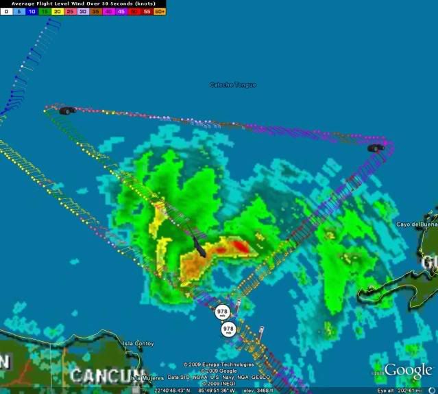
Next pass will be interesting because the solid eyewall area is there and already strong winds haved been recorded.
0 likes
Visit the Caribbean-Central America Weather Thread where you can find at first post web cams,radars
and observations from Caribbean basin members Click Here
and observations from Caribbean basin members Click Here
-
Stormcenter
- S2K Supporter
- Posts: 6689
- Joined: Wed Sep 03, 2003 11:27 am
- Location: Houston, TX
-
WindRunner
- Category 5
- Posts: 5803
- Age: 35
- Joined: Fri Jul 29, 2005 8:07 pm
- Location: Warrenton, VA, but Albany, NY for school
- Contact:
Re:
brunota2003 wrote:It could also be that really big band blocking the radar beam. That radar isnt like the ones back in the states.
That was my first thought...the southern eyewall returns were already weak, and as Cuban (and most older radars) run on C-band radars, attentuation through heavy rain is a significant problem even in the more moderate ranges. I'd watch satellite or the Cancun radar for any signs of degraded appearances.
0 likes

Re: ATL : HURRICANE IDA
This North trend is intersting. It should be a stair step but if it isn't it will have an affect on track.
There's a pan depression in the CDO over the eye.
There's a pan depression in the CDO over the eye.
0 likes
-
jconsor
- Professional-Met
- Posts: 578
- Joined: Mon Jun 30, 2008 9:31 pm
- Location: Jerusalem, Israel
- Contact:
Re:
I think Ida has probably peaked, though it will probably hold steady state for the next 12 hours or so. Satellite shows the CDO becoming elongated SSW-NNE and losing its symmetry, which is a good sign shear is beginning to disrupt the storm's organization.
The caveat is that even storms with a distorted, elongated cloud pattern can still strengthen in moderate shear. One example is Irene in 1999.
The caveat is that even storms with a distorted, elongated cloud pattern can still strengthen in moderate shear. One example is Irene in 1999.
deltadog03 wrote:Derek, I think thats only temp. High res vis showing another big blow up. especially right over center.
Last edited by jconsor on Sun Nov 08, 2009 3:16 pm, edited 2 times in total.
0 likes
-
deltadog03
- Professional-Met
- Posts: 3580
- Joined: Tue Jul 05, 2005 6:16 pm
- Location: Macon, GA
-
brunota2003
- S2K Supporter
- Posts: 9476
- Age: 35
- Joined: Sat Jul 30, 2005 9:56 pm
- Location: Stanton, KY...formerly Havelock, NC
- Contact:
Who is online
Users browsing this forum: No registered users and 15 guests