ATL : TROPICAL DEPRESSION IDA

Moderator: S2k Moderators

Message
Author
ozonepete
Professional-Met
Professional-Met
Posts: 4743
Joined: Mon Sep 07, 2009 3:23 pm
Location: From Ozone Park, NYC / Now in Brooklyn, NY

Re: Re:

#3441 Postby ozonepete » Sun Nov 08, 2009 9:13 pm

attallaman wrote:
deltadog03 wrote:looks like clouds are slightly warming outside of the eyewall. But, it appears the eyewall and around there is starting to show some new colder clouds building. IF** that continues I expect we are going to do the same thing that we did when this last burst started 4 hours ago.
Cloudtops warming, cloudtops cooling, what does that mean? If the cloudtops are warming does that mean a stronger or a weaker system?


Cloudtops warming means weakening. Cloudtops cooling means strengthening.
0 likes   

Cuber
S2K Supporter
S2K Supporter
Posts: 63
Joined: Sun Oct 23, 2005 4:04 pm
Location: Plm Bch Grdns FL

Re: ATL : HURRICANE IDA

#3442 Postby Cuber » Sun Nov 08, 2009 9:13 pm

The following post is NOT an official forecast and should not be used as such. It is just the opinion of the poster and may or may not be backed by sound meteorological data. It is NOT endorsed by any professional institution including storm2k.org For Official Information please refer to the NHC and NWS products.

They just re-painted the water tower in Pensacola .... seems they last painted the water tower back in 2004. Sounds like a valid landfall point to me.

Please be smart and stay safe all of you on the northern gulf coast. South Florida prayers are with you.
0 likes   

User avatar
JTE50
Category 1
Category 1
Posts: 336
Age: 67
Joined: Mon Jul 21, 2008 10:48 am
Location: Pensacola
Contact:

Re: ATL : HURRICANE IDA

#3443 Postby JTE50 » Sun Nov 08, 2009 9:15 pm

Ivanhater wrote:This from the wear 3 website

BREAKING NEWS: Escambia County, Florida - Escambia County, Florida public schools (pre-K - 12th grade) will be closed Monday and Tuesday due to the approach of hurricane Ida. Escambia County, FL declared a state of emergency Sunday evening. They are asking for voluntary evacuations along coastal areas. Bridges will be shut down if winds sustain 45 mph or more.
45mph? Sheesh! For a typhoon in the Philippines they don't shut down anything and you can go anywhere you want - at your own risk of course!
0 likes   

Javlin
Category 5
Category 5
Posts: 1620
Age: 64
Joined: Fri Jul 09, 2004 7:58 pm
Location: ms gulf coast

Re: ATL : HURRICANE IDA

#3444 Postby Javlin » Sun Nov 08, 2009 9:18 pm

Cuber wrote:The following post is NOT an official forecast and should not be used as such. It is just the opinion of the poster and may or may not be backed by sound meteorological data. It is NOT endorsed by any professional institution including storm2k.org For Official Information please refer to the NHC and NWS products.

They just re-painted the water tower in Pensacola .... seems they last painted the water tower back in 2004. Sounds like a valid landfall point to me.

Please be smart and stay safe all of you on the northern gulf coast. South Florida prayers are with you.


:lol: :lol: Now that I call a forcast makes sense :lol:
0 likes   

User avatar
dixiebreeze
S2K Supporter
S2K Supporter
Posts: 5140
Joined: Wed Sep 03, 2003 5:07 pm
Location: crystal river, fla.

Re: ATL : HURRICANE IDA

#3445 Postby dixiebreeze » Sun Nov 08, 2009 9:18 pm

Station 42023 - C13 - West Florida South Buoy

Map data ©2009 Google - Terms of Use
Currently selected station
Stations with recent data
Stations with no data in last 8 hours
(24 hours for tsunami stations) Disclaimer

Owned and maintained by University of South Florida
Offshore Buoy
26.064 N 83.074 W (26°3'49" N 83°4'25" W)

Site elevation: sea level
Air temp height: 2.8 m above site elevation
Anemometer height: 3.2 m above site elevation
Barometer elevation: 2.8 m above mean sea level
Sea temp depth: -1.2 m below site elevation


Latest NWS Marine Forecast

Search And Rescue (SAR) Data

Meteorological Observations from Nearby Stations and Ships

Regional HF Radar Surface Current Observations

Latest Satellite Wind Map for this Area


--------------------------------------------------------------------------------
Conditions at 42023 as of
(8:30 pm EST on 11/08/2009)
0130 GMT on 11/09/2009: Unit of Measure: English Metric Time Zone: Station Local Time Greenwich Mean Time [GMT] British Summer Time [GMT+1] Eastern Greenland [GMT-1] Azores [GMT-2] Western Greenland [GMT-3] Atlantic Standard [GMT-4] US/Eastern Standard US/Central Standard US/Mountain Standard US/Pacific Standard Alaska Standard [GMT-9] Hawaii-Aleutian Standard [GMT-10] Samoa Standard [GMT-11] International Date Line West [GMT-12] Western European [GMT+0] Central European [GMT+1] Eastern European [GMT+2] Moscow [GMT+3] USSR Zone 3 [GMT+4] USSR Zone 4 [GMT+5] USSR Zone 5 [GMT+6] USSR Zone 6 [GMT+7] China Coast [GMT+8] Japan Standard [GMT+9] Guam Standard [GMT+10] GMT+11 International Date Line East [GMT+12]
Click on the graph icon in the table below to see a time series plot of the last five days of that observation.

Wind Speed (WSPD): 25.3 kts
Wind Gust (GST): 31.1 kts
Combined plot of Wind Speed, Gust, and Air Pressure
0 likes   

succubus
Tropical Wave
Tropical Wave
Posts: 2
Age: 43
Joined: Sun Aug 16, 2009 2:15 am

Re: ATL : HURRICANE IDA

#3446 Postby succubus » Sun Nov 08, 2009 9:21 pm

JTE50 wrote:
Ivanhater wrote:This from the wear 3 website

BREAKING NEWS: Escambia County, Florida - Escambia County, Florida public schools (pre-K - 12th grade) will be closed Monday and Tuesday due to the approach of hurricane Ida. Escambia County, FL declared a state of emergency Sunday evening. They are asking for voluntary evacuations along coastal areas. Bridges will be shut down if winds sustain 45 mph or more.
45mph? Sheesh! For a typhoon in the Philippines they don't shut down anything and you can go anywhere you want - at your own risk of course!


It's mostly because of the school buses. It's unsafe for them to operate in winds over 25 or 30 mph, can't remember which. So if half the kids in the school ride the bus, half your students will be out because they won't run the buses. So instead of having so many kids out, they just cancel school. However in some areas private schools will remain open for day care and other services.
0 likes   

attallaman

Re: Re:

#3447 Postby attallaman » Sun Nov 08, 2009 9:23 pm

ozonepete wrote:
Dean4Storms wrote:The NW quadrant should have the highest winds in this scenario with the gradient the tightest there. This would likely be bad for the western Mobile side of Mobile Bay.


If it's TROPICAL, the highest winds will be on the NE or right front quadrant. Remember, even with a tight pressure gradient on the west of a northward moving storm, the left front quadrant or NW quadrant in this case has the forward speed of the storm subtracted from the average winds. The right front quadrant adds the forward speed.
I'm located about 3 miles N of the beach so storm surge wasn't a problem for me during Katrina, the winds in my neighborhood were the problem so are you saying that's it's possible for my area to receive some strong winds coming from the NE to the SW if Ida did make landfall to my E near Mobile if the storm did became ET? Is the L that came out of the BOC still a factor tonight in where Ida will eventually track or is it going to just move into SE TX and SW/SC LA and give those areas copius(sp?) amounts of rain?
0 likes   

Bruton
Tropical Low
Tropical Low
Posts: 19
Age: 37
Joined: Mon Jun 22, 2009 9:58 pm
Location: Miami

#3448 Postby Bruton » Sun Nov 08, 2009 9:24 pm

Can anyone tell me why a Cat 2 does not have an eye on satellite, when much weaker system did have at some point?
0 likes   

ozonepete
Professional-Met
Professional-Met
Posts: 4743
Joined: Mon Sep 07, 2009 3:23 pm
Location: From Ozone Park, NYC / Now in Brooklyn, NY

Re: ATL : HURRICANE IDA

#3449 Postby ozonepete » Sun Nov 08, 2009 9:25 pm

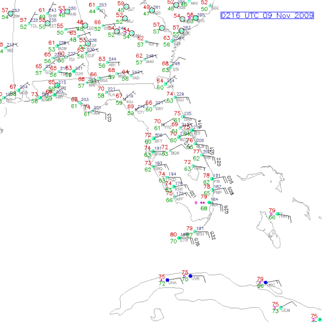
Look at that dry air over Florida, especially central Florida (dewpoints in green). Unless this air moistens up in a hurry from transport over the Gulf waters, there could be more weakening tomorrow than forecast.

Image
0 likes   

attallaman

Re:

#3450 Postby attallaman » Sun Nov 08, 2009 9:25 pm

nashrobertsx wrote:Someone start posting the 0Z models, please.
The NAM takes it to ala-fla border
As a CAT 1?
0 likes   

User avatar
baygirl_1
S2K Supporter
S2K Supporter
Posts: 825
Joined: Wed Aug 11, 2004 4:06 pm
Location: Mobile, AL

Re: ATL : HURRICANE IDA

#3451 Postby baygirl_1 » Sun Nov 08, 2009 9:26 pm

succubus wrote:
JTE50 wrote:
Ivanhater wrote:This from the wear 3 website

BREAKING NEWS: Escambia County, Florida - Escambia County, Florida public schools (pre-K - 12th grade) will be closed Monday and Tuesday due to the approach of hurricane Ida. Escambia County, FL declared a state of emergency Sunday evening. They are asking for voluntary evacuations along coastal areas. Bridges will be shut down if winds sustain 45 mph or more.
45mph? Sheesh! For a typhoon in the Philippines they don't shut down anything and you can go anywhere you want - at your own risk of course!


It's mostly because of the school buses. It's unsafe for them to operate in winds over 25 or 30 mph, can't remember which. So if half the kids in the school ride the bus, half your students will be out because they won't run the buses. So instead of having so many kids out, they just cancel school. However in some areas private schools will remain open for day care and other services.

Also, there's the rising water. Mobile County, AL has NOT closed schools, yet, but we have a school on Dauphin Island and several in the Bayou La Batre area. Those areas will be affected by coastal flooding before the rest of the county. We'll see what they decide to do about those.
0 likes   

ozonepete
Professional-Met
Professional-Met
Posts: 4743
Joined: Mon Sep 07, 2009 3:23 pm
Location: From Ozone Park, NYC / Now in Brooklyn, NY

Re:

#3452 Postby ozonepete » Sun Nov 08, 2009 9:26 pm

Bruton wrote:Can anyone tell me why a Cat 2 does not have an eye on satellite, when much weaker system did have at some point?


There are strong southerly winds at the upper levels, and they are blowing cirrus clouds over the eye.
0 likes   

Dean4Storms
S2K Supporter
S2K Supporter
Posts: 6358
Age: 62
Joined: Sun Aug 31, 2003 1:01 pm
Location: Miramar Bch. FL

Re: Re:

#3453 Postby Dean4Storms » Sun Nov 08, 2009 9:27 pm

attallaman wrote:
Sabanic wrote:
Dean4Storms wrote:I'm thinking the P'Cola area, there has to be a bend toward the NNE to NE south of Mobile.


Others have stated here that the North & West side of Ida is the strongest. If this is correct than a bend to the NNE-NE just south of Mobile would be the worst case scenario for this area
So if I understand what others have said tonight if Ida does go ET the strongest quadrant of the storm would be the NW one? If the storm did make landfall near Mobile instead of Pensacola and I'm in Biloxi would I receive stronger winds in my area than areas to the E of Mobile if the storm did make landfall near Mobile? I assume that would depend upon how large Ida's windfield would be at the time of landfall. Would that be correct?


It is not going to matter tropical or non tropical, the front coming in from the NW with the strong High behind it is the reason for the NW side seeing the strongest winds in this scenario. Most of the time the highest winds are in the NE Quad and they are currently with Ida. But once near landfall the squeeze will be on as Ida bumps into the higher pressure rushing in from the north, therefore the pressure gradient will be strongest on the NW side of this storm as that begins to occur.

So yes, whoever is just to the NW of Ida or directly under her center will see some of the strongest winds as she passes and the high pressure rushes in, the pressure gradient will be strongest there.
0 likes   

User avatar
deltadog03
Professional-Met
Professional-Met
Posts: 3580
Joined: Tue Jul 05, 2005 6:16 pm
Location: Macon, GA

#3454 Postby deltadog03 » Sun Nov 08, 2009 9:28 pm

I think we all have to realize that we can't treat this cane as a normal time/summer time cane. There is going to be many different things that we don't see in summer. Those td's that are in the low to mid 60's arent bad for this time of year. There is some fairly cool air at 10k near IDA. The low temps at flight level prove that as well as HAIL in the N quad.
Last edited by deltadog03 on Sun Nov 08, 2009 9:33 pm, edited 1 time in total.
0 likes   

attallaman

Re: Re:

#3455 Postby attallaman » Sun Nov 08, 2009 9:28 pm

Evil Jeremy wrote:
attallaman wrote:
deltadog03 wrote:looks like clouds are slightly warming outside of the eyewall. But, it appears the eyewall and around there is starting to show some new colder clouds building. IF** that continues I expect we are going to do the same thing that we did when this last burst started 4 hours ago.
Cloudtops warming, cloudtops cooling, what does that mean? If the cloudtops are warming does that mean a stronger or a weaker system?

Generally warming cloudtops indicate weakening, and colder ones indicate strengthening.
Thanks for that info.
0 likes   

ozonepete
Professional-Met
Professional-Met
Posts: 4743
Joined: Mon Sep 07, 2009 3:23 pm
Location: From Ozone Park, NYC / Now in Brooklyn, NY

Re:

#3456 Postby ozonepete » Sun Nov 08, 2009 9:32 pm

deltadog03 wrote:I think we all have to realize that we can't treat this cane as a normal time/summer time cane. There is going to be many different things that we don't see in summer. Those td's that are in the low to mid 60's arent bad for this time of year. There is come fairly cool air at 10k near IDA. The low temps at flight level prove that as well as HAIL in the N quad.


great point about the Hail. You obviously know your mesoscale. :)
0 likes   

Dean4Storms
S2K Supporter
S2K Supporter
Posts: 6358
Age: 62
Joined: Sun Aug 31, 2003 1:01 pm
Location: Miramar Bch. FL

Re: Re:

#3457 Postby Dean4Storms » Sun Nov 08, 2009 9:32 pm

[/quote]

Others have stated here that the North & West side of Ida is the strongest. If this is correct than a bend to the NNE-NE just south of Mobile would be the worst case scenario for this area[/quote]So if I understand what others have said tonight if Ida does go ET the strongest quadrant of the storm would be the NW one? If the storm did make landfall near Mobile instead of Pensacola and I'm in Biloxi would I receive stronger winds in my area than areas to the E of Mobile if the storm did make landfall near Mobile? I assume that would depend upon how large Ida's windfield would be at the time of landfall. Would that be correct?[/quote]

It is not going to matter tropical or non tropical, the front coming in from the NW with the strong High behind it is the reason for the NW side seeing the strongest winds in this scenario. Most of the time the highest winds are in the NE Quad and they are currently with Ida. But once near landfall the squeeze will be on as Ida bumps into the higher pressure rushing in from the north, therefore the pressure gradient will be strongest on the NW side of this storm as that begins to occur.

So yes, whoever is just to the NW of Ida or directly under her center will see some of the strongest winds as she passes and the high pressure rushes in, the pressure gradient will be strongest there.[/quote]

I should have included, so long as the front has caught Ida, which that is a ? right now!
0 likes   

User avatar
Blown Away
S2K Supporter
S2K Supporter
Posts: 10146
Joined: Wed May 26, 2004 6:17 am

Re: ATL : HURRICANE IDA

#3458 Postby Blown Away » Sun Nov 08, 2009 9:32 pm

JTE50 wrote:
Ivanhater wrote:This from the wear 3 website

BREAKING NEWS: Escambia County, Florida - Escambia County, Florida public schools (pre-K - 12th grade) will be closed Monday and Tuesday due to the approach of hurricane Ida. Escambia County, FL declared a state of emergency Sunday evening. They are asking for voluntary evacuations along coastal areas. Bridges will be shut down if winds sustain 45 mph or more.
45mph? Sheesh! For a typhoon in the Philippines they don't shut down anything and you can go anywhere you want - at your own risk of course!


These days w/ so many folks living along the coast I guess it's better to error on the safe side. But I can remember back 30 years ago when David came through it seemed the whole town was at the beach during the eye and the local restaurant/pub was serving food. Winds were gusting in the 90mph range. Times have changed and it's part of the media machine.
0 likes   
Hurricane Eye Experience: David 79, Irene 99, Frances 04, Jeanne 04, Wilma 05... EYE COMING MY WAY IN 2024…
Hurricane Brush Experience: Andrew 92, Erin 95, Floyd 99, Matthew 16, Irma 17, Ian 22, Nicole 22…

Aric Dunn
Category 5
Category 5
Posts: 21238
Age: 42
Joined: Sun Sep 19, 2004 9:58 pm
Location: Ready for the Chase.
Contact:

Re: ATL : HURRICANE IDA

#3459 Postby Aric Dunn » Sun Nov 08, 2009 9:34 pm

ozonepete wrote:Look at that dry air over Florida, especially central Florida (dewpoints in green). Unless this air moistens up in a hurry from transport over the Gulf waters, there could be more weakening tomorrow than forecast.

Image


in normal circumstances yes.. but there is a old boundary running NW to SE across the eastern gulf. this boundary is one of the reason IDA has not ingested dry air thus far. the boundary should remain. and will eventually lift back across florida after ida makes landfall which should finally bring the rain back across the state..
0 likes   

smw1981
S2K Supporter
S2K Supporter
Posts: 253
Joined: Tue Jul 31, 2007 9:04 pm
Location: Alabamer

Re: ATL : HURRICANE IDA

#3460 Postby smw1981 » Sun Nov 08, 2009 9:34 pm

baygirl_1 wrote:

Also, there's the rising water. Mobile County, AL has NOT closed schools, yet, but we have a school on Dauphin Island and several in the Bayou La Batre area. Those areas will be affected by coastal flooding before the rest of the county. We'll see what they decide to do about those.[/quote]

They will close them (in Mobile Co.) if a Hurricane Warning is issued. What would suck is if one is issued in the middle of the night (I would guess they will issue one at midnight for us), and all of the parents wake up in the morning and have nothing to do with their children for the day because they still have to go to work. We have already called the parents from my school just to give them the heads up...

As of 7pm, Baldwin Co. schools were to be open tomorrow, although that may change if a Hurricane Warning is issued...

Anyways, that is what Mobile Co. is waiting on to decide...
0 likes   


Return to “2009”

Who is online

Users browsing this forum: No registered users and 2 guests