ATL : TROPICAL DEPRESSION IDA
Moderator: S2k Moderators

-
IvanSurvivor
- Tropical Storm

- Posts: 152
- Joined: Wed Aug 20, 2008 12:12 am
- Location: Pensacola Florida (Warrington)
Someone on Channel 3 news...think he's associated with Escambia County Emergency Management was just talking about evacs...said barrier islands by tomorrow morning, nlt tomorrow afternoon. Indicated there are other areas (low lying, etc), but specifically said barrier islands. Right now it's voluntary I think.
0 likes


Re:
AdamFirst wrote:What would a loop bring in terms of weather to the lower peninsula? I understand it won't be anywhere near from what the Gulf coast is going to get, but if the extratropical low cruises down the spine of the peninsula, I guess we'll potentially see severe weather?
Here in NE Florida, we get a ton of remnants from storms hitting other parts of the state. Basically, expect tornado warnings to go up, reports to hit quite often. Heavy rain at times. Winds mostly limited with an occasional band of high winds, etc.. Makes for a fun ride at times.
0 likes
-
ozonepete
- Professional-Met

- Posts: 4743
- Joined: Mon Sep 07, 2009 3:23 pm
- Location: From Ozone Park, NYC / Now in Brooklyn, NY
Re: ATL : HURRICANE IDA
IvanSurvivor wrote:IvanSurvivor wrote:JTE50 wrote:The Weather Channel's Jim Cantore is in Pensacola Beach now.
Confirmed?
We might know for sure if TWC actually reported weather instead of Storm Stories or March of the Penguins, etc.
LOL!!!!!
0 likes
-
Dave

- Retired Staff

- Posts: 13442
- Age: 75
- Joined: Tue Aug 01, 2006 3:57 pm
- Location: Milan Indiana
- Contact:
URNT15 KNHC 090413
AF304 0611A IDA HDOB 06 20091109
040530 2855N 08912W 4100 07368 0358 -176 -189 179038 038 999 999 03
040600 2853N 08912W 4095 07374 0357 -179 -188 181038 038 999 999 03
040630 2851N 08912W 4097 07368 0355 -180 -193 181038 039 999 999 03
040700 2849N 08912W 4098 07366 0354 -179 -196 181037 037 999 999 03
040730 2847N 08912W 4100 07362 0351 -178 -197 181036 037 999 999 03
040800 2845N 08912W 4105 07341 0341 -177 -196 181036 036 999 999 03
040830 2843N 08912W 4098 07353 0341 -178 -192 181035 035 999 999 03
040900 2840N 08912W 4101 07347 0341 -176 -179 180036 037 999 999 03
040930 2838N 08912W 4097 07355 0341 -175 -176 179034 035 999 999 03
041000 2836N 08912W 4099 07352 0341 -175 -177 180034 035 999 999 03
041030 2834N 08912W 4098 07352 0341 -175 -175 178035 035 999 999 03
041100 2831N 08912W 4099 07351 0341 -175 -177 175036 036 999 999 03
041130 2829N 08912W 4100 07350 0341 -175 -179 178035 035 999 999 03
041200 2827N 08912W 4098 07351 0340 -175 -178 178034 034 999 999 03
041230 2825N 08912W 4100 07348 0339 -175 -179 179033 034 999 999 03
041300 2822N 08912W 4098 07350 0339 -175 -175 174032 032 999 999 03
041330 2820N 08912W 4099 07348 0339 -175 -175 173032 032 999 999 03
041400 2818N 08912W 4099 07352 0342 -175 -177 172033 034 999 999 03
041430 2816N 08912W 4099 07352 0342 -175 -175 173034 035 999 999 03
041500 2813N 08912W 4098 07353 0342 -175 -175 174033 034 999 999 03
$$
;
0 likes


Re: ATL : HURRICANE IDA
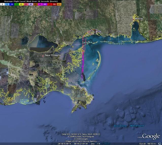
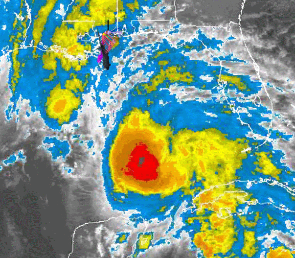
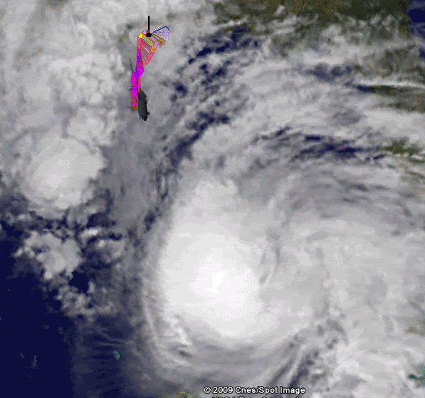
Is the outflow on the western side looking a little better? or am I seeing things...just noticed some feathery cirrus blowing westward off the storm where it previously looked flat on the west side.
0 likes


Re:
IvanSurvivor wrote:Someone on Channel 3 news...think he's associated with Escambia County Emergency Management was just talking about evacs...said barrier islands by tomorrow morning, nlt tomorrow afternoon. Indicated there are other areas (low lying, etc), but specifically said barrier islands. Right now it's voluntary I think.
from an official source: http://www.pnj.com/article/20091108/NEWS01/911080319
I think the good folks here want this kind of stuff on another thread.
0 likes
-
IvanSurvivor
- Tropical Storm
- Posts: 152
- Joined: Wed Aug 20, 2008 12:12 am
- Location: Pensacola Florida (Warrington)
Within 10 minutes local news showed storm surge of 5 ft...then in full forecast says 5-7 ft...
I know there is nothing we can do about it regardless, but it would be nice to have the accurate info for those of us in low lying areas.
Can anyone answer my question from earlier about is high tide added on top of storm surge amount or is it already factored in? Storm surge= 5 ft total or 5 ft Storm Surge plus an additional 2-3 ft from high tide= 7-8 ft total?
0 likes
-
tolakram
- Admin

- Posts: 20186
- Age: 62
- Joined: Sun Aug 27, 2006 8:23 pm
- Location: Florence, KY (name is Mark)
Re: ATL : HURRICANE IDA
http://wwwghcc.msfc.nasa.gov/cgi-bin/ge ... mframes=17
Cirrus moving clockwise ... a high building above Ida, or simply being blown NE by the upper level winds.?
Cirrus moving clockwise ... a high building above Ida, or simply being blown NE by the upper level winds.?
0 likes
M a r k
- - - - -
Join us in chat: Storm2K Chatroom Invite. Android and IOS apps also available.
The posts in this forum are NOT official forecasts and should not be used as such. Posts are NOT endorsed by any professional institution or STORM2K.org. For official information and forecasts, please refer to NHC and NWS products.
Re: ATL : HURRICANE IDA
Usually predictions in the local statements INCLUDE the high tide. the levels stated are from mean tide.
0 likes
-
dixiebreeze

- S2K Supporter

- Posts: 5140
- Joined: Wed Sep 03, 2003 5:07 pm
- Location: crystal river, fla.
-
Dave
- Retired Staff
- Posts: 13442
- Age: 75
- Joined: Tue Aug 01, 2006 3:57 pm
- Location: Milan Indiana
- Contact:
URNT15 KNHC 090423
AF304 0611A IDA HDOB 07 20091109
041530 2811N 08912W 4098 07354 0343 -176 -176 175035 036 999 999 03
041600 2809N 08911W 4099 07353 0344 -175 -175 180034 035 999 999 03
041630 2807N 08911W 4099 07355 0344 -176 -176 181034 034 999 999 03
041700 2805N 08911W 4100 07354 0344 -173 -173 179033 036 999 999 03
041730 2802N 08910W 4103 07348 0345 -171 +999 182031 037 999 999 05
041800 2800N 08910W 4102 07351 0346 -167 +999 178032 037 999 999 05
041830 2758N 08910W 4106 07341 0345 -176 +999 179027 029 999 999 05
041900 2756N 08910W 4101 07353 0345 -180 +999 177028 029 999 999 05
041930 2754N 08909W 4100 07354 0345 -181 +999 182030 032 999 999 05
042000 2752N 08909W 4098 07355 0343 -177 +999 185029 031 999 999 05
042030 2749N 08909W 4099 07353 0343 -175 +999 185028 029 999 999 05
042100 2747N 08908W 4099 07352 0341 -175 -178 186028 028 999 999 05
042130 2745N 08908W 4098 07354 0342 -180 -180 178028 029 999 999 03
042200 2743N 08908W 4100 07350 0342 -180 -181 182027 028 999 999 03
042230 2741N 08908W 4097 07356 0342 -181 -182 184026 027 999 999 03
042300 2739N 08907W 4098 07355 0342 -180 -180 182027 028 999 999 03
042330 2737N 08907W 4099 07352 0343 -179 -179 179026 027 999 999 03
042400 2735N 08907W 4100 07353 0344 -181 -181 183025 026 999 999 03
042430 2733N 08907W 4098 07355 0345 -181 -181 181027 027 999 999 03
042500 2731N 08906W 4098 07356 0345 -180 -181 181025 025 999 999 03
$$
;
0 likes
Re:
IvanSurvivor wrote:Within 10 minutes local news showed storm surge of 5 ft...then in full forecast says 5-7 ft...
I know there is nothing we can do about it regardless, but it would be nice to have the accurate info for those of us in low lying areas.
Can anyone answer my question from earlier about is high tide added on top of storm surge amount or is it already factored in? Storm surge= 5 ft total or 5 ft Storm Surge plus an additional 2-3 ft from high tide= 7-8 ft total?
I've always interpreted it to mean - whatever the storm surge is added to the tide level that is occuring at landfall. Just to be safe I would factor in a high tide. Maybe someone in Emergency Managment can chime in.
0 likes
Re:
IvanSurvivor wrote:Within 10 minutes local news showed storm surge of 5 ft...then in full forecast says 5-7 ft...
I know there is nothing we can do about it regardless, but it would be nice to have the accurate info for those of us in low lying areas.
Can anyone answer my question from earlier about is high tide added on top of storm surge amount or is it already factored in? Storm surge= 5 ft total or 5 ft Storm Surge plus an additional 2-3 ft from high tide= 7-8 ft total?
I am pretty sure that it does not take in effect the tide. There is an awesome graphic on a page wayyyy back (but from today) that showed the surge plus tidal times (like if it hit at low tide, how high the surge would be, etc.). That is why I think surge is different from tide, so that would mean 5 ft storm surge plus 2-3ft during high tide=7-8ft total. I will try to find that graphic real quick and repost it for you...
0 likes
-
IvanSurvivor
- Tropical Storm
- Posts: 152
- Joined: Wed Aug 20, 2008 12:12 am
- Location: Pensacola Florida (Warrington)
Re: Re:
JTE50 wrote:IvanSurvivor wrote:Within 10 minutes local news showed storm surge of 5 ft...then in full forecast says 5-7 ft...
I know there is nothing we can do about it regardless, but it would be nice to have the accurate info for those of us in low lying areas.
Can anyone answer my question from earlier about is high tide added on top of storm surge amount or is it already factored in? Storm surge= 5 ft total or 5 ft Storm Surge plus an additional 2-3 ft from high tide= 7-8 ft total?
I've always interpreted it to mean - whatever the storm surge is added to the tide level that is occuring at landfall. Just to be safe I would factor in a high tide. Maybe someone in Emergency Managment can chime in.
Thanks PTPatrick, JTE50, SMW1981 and Derek... when you are at 7.5 ft elevation, 2-3 ft extra can make a huge, wet difference!
Last edited by IvanSurvivor on Sun Nov 08, 2009 11:41 pm, edited 2 times in total.
0 likes
-
Derek Ortt
-
Dave
- Retired Staff
- Posts: 13442
- Age: 75
- Joined: Tue Aug 01, 2006 3:57 pm
- Location: Milan Indiana
- Contact:
URNT15 KNHC 090433
AF304 0611A IDA HDOB 08 20091109
042530 2729N 08906W 4100 07353 0345 -180 -182 180025 026 999 999 03
042600 2727N 08906W 4099 07356 0345 -180 -183 177025 025 999 999 03
042630 2724N 08905W 4098 07359 0345 -180 -184 180025 027 999 999 03
042700 2722N 08905W 4097 07359 0344 -179 -186 183025 026 999 999 03
042730 2720N 08905W 4100 07353 0344 -179 -187 180024 025 999 999 03
042800 2718N 08905W 4098 07356 0345 -180 -188 176022 023 999 999 03
042830 2716N 08904W 4098 07356 0345 -179 -187 177023 025 999 999 03
042900 2714N 08904W 4099 07355 0344 -177 -186 180023 023 999 999 03
042930 2712N 08904W 4099 07353 0344 -177 -188 185022 023 999 999 03
043000 2710N 08904W 4098 07355 0343 -180 -189 185023 023 999 999 03
043030 2708N 08903W 4098 07355 0343 -180 -189 184021 022 999 999 03
043100 2706N 08903W 4098 07355 0345 -180 -189 187022 022 999 999 03
043130 2704N 08903W 4101 07356 0348 -176 -188 189022 023 999 999 03
043200 2702N 08902W 4099 07356 0347 -175 -186 191020 021 999 999 03
043230 2659N 08902W 4099 07359 0349 -179 -187 184018 018 999 999 03
043300 2657N 08902W 4098 07361 0349 -179 -188 185017 018 999 999 03
043330 2655N 08902W 4098 07360 0349 -177 -190 188018 019 999 999 03
043400 2653N 08901W 4098 07360 0349 -170 -194 196019 020 999 999 03
043430 2651N 08901W 4098 07363 0349 -167 -197 193020 021 999 999 03
043500 2649N 08901W 4101 07358 0350 -177 -192 188019 021 999 999 03
$$
;
0 likes
Who is online
Users browsing this forum: No registered users and 77 guests