Product: Air Force Tropical RECCO Message (URNT11 KNHC)
Transmitted: 9th day of the month at 04:32Z
Aircraft: Air Force Aircraft (Last 3 digits of the tail number are 304)
Storm Number: 11
Storm Name: Ida (flight in the North Atlantic basin)
Mission Number: 6
Observation Number: 02
Mandatory Data...
Observation Time: Monday, 4:30Z
Radar Capability: Yes
Aircraft Altitude: Below 10,000 meters
Coordinates: 27.1N 89.1W
Location: 207 miles (333 km) to the SSE (164°) from New Orleans, LA, USA.
Turbulence: None
Conditions Along Flight Route: In the clear
Pressure Altitude: 7,010 meters
Flight Level Wind: From 180° at 21 knots (From the S at ~ 24.1 mph)
- The above is a spot wind.
- Winds were obtained using doppler radar or inertial systems.
Flight Level Temperature: -18°C
Flight Level Dew Point: -19°C
Weather (within 30 nautical miles): Clear
400 mb Surface Altitude: 7,540 geopotential meters
ATL : TROPICAL DEPRESSION IDA
Moderator: S2k Moderators


Re:
IvanSurvivor wrote:Within 10 minutes local news showed storm surge of 5 ft...then in full forecast says 5-7 ft...
I know there is nothing we can do about it regardless, but it would be nice to have the accurate info for those of us in low lying areas.
Can anyone answer my question from earlier about is high tide added on top of storm surge amount or is it already factored in? Storm surge= 5 ft total or 5 ft Storm Surge plus an additional 2-3 ft from high tide= 7-8 ft total?
from the NHC -
SUBJECT: CHANGES TO STORM SURGE INFORMATION IN TROPICAL
CYCLONE PUBLIC ADVISORIES FROM THE NATIONAL
HURRICANE CENTER: EFFECTIVE MAY 15 2009
REFERENCE: SERVICE CHANGE NOTICE 09-14 ISSUED FEB 24 2009
STARTING IN 2009...IN AN EFFORT TO ENSURE STORM SURGE FORECASTS
ARE FULLY UNDERSTOOD BY THE WIDEST POSSIBLE AUDIENCE...THE
NATIONAL HURRICANE CENTER /NHC/ WILL CHANGE THE WORDING IN THE
PUBLIC ADVISORY TEXT PRODUCTS TO REFERENCE STORM SURGE OR STORM
TIDE IN TERMS OF HEIGHT ABOVE GROUND LEVEL.
STORM SURGE REFERS TO THE ABNORMAL RISE IN SEA LEVEL
ACCOMPANYING A HURRICANE...THE DIFFERENCE BETWEEN THE OBSERVED
LEVEL OF THE SEA SURFACE AND THE LEVEL THAT WOULD HAVE OCCURRED
IN THE ABSENCE OF THE CYCLONE.
STORM TIDE IS THE ACTUAL LEVEL OF SEA WATER RESULTING FROM THE
ASTRONOMIC TIDE COMBINED WITH THE STORM SURGE. STORM TIDE IS OF
PARTICULAR IMPORTANCE IN THE NORTHERN LATITUDES...WHERE
THERE IS A GREATER DIFFERENCE IN HEIGHTS BETWEEN HIGH AND LOW
TIDE LEVELS...AND WHEN A STORM IS EXPECTED TO LANDFALL NEAR THE
TIMES OF ASTRONOMICAL HIGH TIDE.
BEGINNNING IN 2009...NHC PUBLIC ADVISORY PRODUCTS /TCP/S WILL
PROVIDE THE FOLLOWING POSSIBLE STATEMENTS ON COASTAL FLOODING
ASSOCIATED WITH TROPICAL CYCLONES:
EXAMPLE 1
STORM SURGE WILL RAISE WATER LEVELS BY AS MUCH AS NN /FOR
EXAMPLE 15/ FEET ABOVE GROUND LEVEL ALONG THE COAST...WITH LARGE
AND DANGEROUS BATTERING WAVES...NEAR AND TO THE ZZZZ /DIRECTION
FOR EXAMPLE EAST/ OF WHERE THE CENTER MAKES LANDFALL. THE SURGE
COULD PENETRATE AS FAR INLAND AS ABOUT NN /FOR EXAMPLE 30/ MILES
FROM THE SHORE WITH DEPTH GENERALLY DECREASING AS THE WATER
MOVES INLAND.
EXAMPLE 2
STORM TIDE WILL RAISE WATER LEVELS BY AS MUCH AS NN /FOR EXAMPLE
18/ FEET ABOVE GROUND LEVEL ALONG THE COAST...WITH LARGE AND
DANGEROUS BATTERING WAVES...NEAR AND TO THE ZZZZ /DIRECTION FOR
EXAMPLE EAST/ OF WHERE THE CENTER MAKES LANDFALL. STORM TIDE
COULD PENETRATE AS FAR INLAND AS ABOUT NN /FOR EXAMPLE 30/ MILES
FROM THE SHORE WITH DEPTH GENERALLY DECREASING AS THE WATER
MOVES INLAND.
PLEASE SEE SERVICE CHANGE NOTICE 09-14...ISSUED ON FEB 24
2009...FOR FORMAT CHANGES TO TROPICAL CYCLONE PUBLIC ADVISORY
PRODUCTS FOR THE ATLANTIC...EAST PACIFIC...AND CENTRAL PACIFIC
HURRICANE BASINS: EFFECTIVE MAY 15 2009.
AN EXAMPLE OF THE TCP PRODUCT FOR 2009 IS PROVIDED ONLINE AT
/USE LOWER CASE LETTERS/:
http://www.nhc.noaa.gov/pns8_2009.shtml
0 likes
-
deltadog03

- Professional-Met

- Posts: 3580
- Joined: Tue Jul 05, 2005 6:16 pm
- Location: Macon, GA


-
IvanSurvivor
- Tropical Storm

- Posts: 152
- Joined: Wed Aug 20, 2008 12:12 am
- Location: Pensacola Florida (Warrington)
-
Dave

- Retired Staff

- Posts: 13442
- Age: 75
- Joined: Tue Aug 01, 2006 3:57 pm
- Location: Milan Indiana
- Contact:
URNT15 KNHC 090444
AF304 0611A IDA HDOB 09 20091109
043530 2647N 08900W 4093 07369 0349 -172 -196 195019 019 999 999 03
043600 2645N 08900W 4098 07360 0347 -171 -199 195018 018 999 999 03
043630 2642N 08900W 4097 07361 0346 -169 -202 197018 019 999 999 03
043700 2640N 08900W 4098 07356 0345 -162 -209 201018 019 999 999 03
043730 2638N 08859W 4098 07358 0346 -166 -211 199016 017 999 999 03
043800 2635N 08859W 4101 07353 0345 -168 -206 199016 018 999 999 03
043830 2633N 08859W 4098 07357 0345 -167 -209 206016 018 999 999 03
043900 2631N 08858W 4099 07355 0345 -159 -212 208018 018 999 999 03
043930 2628N 08858W 4102 07350 0345 -149 -218 208020 020 999 999 03
044000 2626N 08858W 4096 07359 0344 -146 -219 206020 020 999 999 03
044030 2623N 08857W 4101 07351 0343 -145 -219 207020 020 999 999 03
044100 2621N 08857W 4099 07353 0343 -149 -218 206020 020 999 999 03
044130 2619N 08856W 4112 07334 0344 -148 -218 200018 020 999 999 03
044200 2617N 08854W 4215 07148 0336 -148 -208 204015 016 999 999 03
044230 2615N 08853W 4316 06972 0328 -148 -189 186013 014 999 999 03
044300 2613N 08851W 4434 06766 0317 -129 -180 187011 012 999 999 03
044330 2611N 08850W 4549 06572 0308 -110 -172 198013 014 999 999 03
044400 2609N 08848W 4665 06377 0296 -094 -163 206009 010 999 999 03
044430 2607N 08847W 4778 06193 0286 -078 -155 201007 009 999 999 03
044500 2605N 08845W 4901 05995 0275 -072 -141 169005 006 999 999 03
$$
;
Descending to operational altitude
0 likes
Re: ATL : HURRICANE IDA
cycloneye wrote:Below is a chart of when the high tides will be during landfall somewhere in the gulf coast.

Ivan...Finally found it after looking at 20 pages lol...I hope this answers your question..
0 likes
-
IvanSurvivor
- Tropical Storm
- Posts: 152
- Joined: Wed Aug 20, 2008 12:12 am
- Location: Pensacola Florida (Warrington)
Re:
IvanSurvivor wrote:Thanks to all that answered my post...looks like we might take a little water again. All puckered up and soon to be hunkered down...
I hope you all are safe without damage and I hope the Portofino survives
One of our favorite places to stay.
0 likes
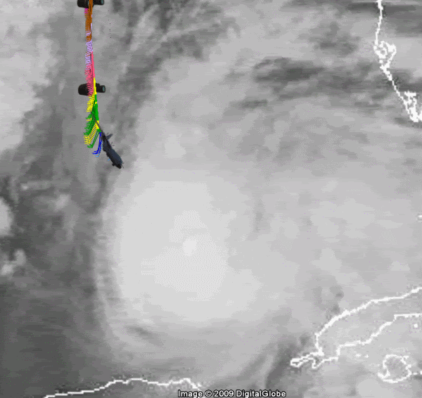

Re: ATL : HURRICANE IDA
seems like on latest image that due north better commence soon if the storm is make its next point, otherwise might miss it a hair west...which will be a first for today
0 likes
-
Dave
- Retired Staff
- Posts: 13442
- Age: 75
- Joined: Tue Aug 01, 2006 3:57 pm
- Location: Milan Indiana
- Contact:
URNT15 KNHC 090453
AF304 0611A IDA HDOB 10 20091109
044530 2603N 08844W 5057 05755 0264 -059 -126 160009 010 999 999 03
044600 2601N 08842W 5315 05363 0242 -033 -110 173008 009 999 999 03
044630 2559N 08841W 5563 04997 0067 -017 -092 168012 013 999 999 03
044700 2558N 08839W 5811 04650 0078 -000 -076 146010 011 999 999 03
044730 2556N 08838W 6062 04311 0090 +016 -065 125017 017 999 999 03
044800 2554N 08836W 6313 03981 0090 +036 -055 115018 019 999 999 03
044830 2552N 08835W 6486 03761 0080 +056 -045 118016 017 999 999 03
044900 2551N 08834W 6636 03570 0075 +070 -035 106015 016 999 999 03
044930 2549N 08833W 6793 03375 0077 +079 -023 094020 023 999 999 03
045000 2548N 08831W 6947 03189 0100 +070 -013 103025 026 999 999 03
045030 2546N 08830W 6967 03160 0096 +070 -005 103025 026 999 999 03
045100 2545N 08829W 6962 03164 0092 +072 +000 104022 024 999 999 03
045130 2544N 08828W 6970 03155 0086 +075 +005 107020 021 999 999 03
045200 2542N 08827W 6966 03159 0071 +086 +008 109017 018 999 999 03
045230 2541N 08826W 6970 03154 0073 +083 +011 109020 021 999 999 03
045300 2540N 08824W 6967 03157 0065 +091 +012 115019 020 999 999 03
045330 2539N 08823W 6965 03162 0082 +078 +014 114016 018 999 999 03
045400 2538N 08822W 6966 03178 0096 +077 +013 116012 013 999 999 03
045430 2537N 08820W 6970 03172 0109 +073 +013 114019 022 999 999 03
045500 2535N 08819W 6962 03182 0096 +081 +012 112023 024 999 999 03
$$
;
0 likes
-
AdamFirst

- S2K Supporter

- Posts: 2490
- Age: 36
- Joined: Thu Aug 14, 2008 10:54 am
- Location: Port Saint Lucie, FL
I can help out with the Google Earth images if you show me how to input those.
0 likes
Dolphins Marlins Canes Golden Panthers HEAT
Andrew 1992 - Irene 1999 - Frances 2004 - Jeanne 2004 - Wilma 2005 - Fay 2008 - Isaac 2012 - Matthew 2016 - Irma 2017 - Dorian 2019 - Ian 2022 - Nicole 2022 - Milton 2024
Andrew 1992 - Irene 1999 - Frances 2004 - Jeanne 2004 - Wilma 2005 - Fay 2008 - Isaac 2012 - Matthew 2016 - Irma 2017 - Dorian 2019 - Ian 2022 - Nicole 2022 - Milton 2024
-
Dave
- Retired Staff
- Posts: 13442
- Age: 75
- Joined: Tue Aug 01, 2006 3:57 pm
- Location: Milan Indiana
- Contact:
URNT15 KNHC 090503
AF304 0611A IDA HDOB 11 20091109
045530 2534N 08818W 6968 03174 0093 +083 +012 108023 023 999 999 03
045600 2533N 08817W 6968 03171 0094 +084 +011 106023 024 999 999 03
045630 2532N 08815W 6961 03185 0084 +092 +011 093023 024 999 999 03
045700 2531N 08814W 6971 03172 0089 +089 +013 090027 028 999 999 03
045730 2530N 08813W 6959 03188 0093 +087 +012 082024 026 999 999 03
045800 2529N 08811W 6962 03185 0099 +082 +012 068026 027 999 999 03
045830 2527N 08810W 6971 03175 0106 +078 +010 060025 025 040 005 03
045900 2526N 08809W 6972 03172 0112 +073 +009 057027 028 041 005 00
045930 2525N 08807W 6962 03183 0129 +058 +008 067030 034 043 008 00
050000 2524N 08806W 6960 03184 0142 +048 +005 079035 038 047 013 00
050030 2523N 08805W 6974 03162 0142 +046 +002 094042 045 045 019 00
050100 2522N 08804W 6955 03185 0140 +045 +001 097043 046 039 012 00
050130 2521N 08803W 6974 03162 0119 +061 +001 104034 037 035 008 00
050200 2520N 08801W 6967 03171 0107 +070 +003 101031 033 033 006 00
050230 2518N 08800W 6967 03169 0100 +074 +006 097032 033 034 006 00
050300 2517N 08759W 6968 03168 0107 +067 +008 095037 039 034 009 00
050330 2516N 08758W 6965 03167 0110 +064 +009 096035 037 036 009 00
050400 2515N 08756W 6967 03163 0110 +062 +010 094035 036 038 012 00
050430 2514N 08755W 6974 03157 0114 +057 +009 101037 038 037 010 00
050500 2513N 08754W 6964 03166 0096 +070 +009 099037 037 031 008 00
$$
;
Operational Altitude
0 likes
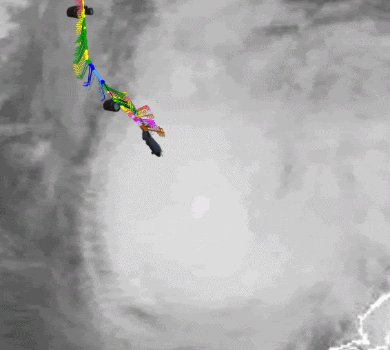
Re: ATL : HURRICANE IDA
PTPatrick wrote:seems like on latest image that due north better commence soon if the storm is make its next point, otherwise might miss it a hair west...which will be a first for today
Latest sat is showing a stretch of N-S in cloud structure will probably happen soon.Kevin
she is book'in it might miss'it by some 12-18(W) miles before the change.
Last edited by Javlin on Mon Nov 09, 2009 12:16 am, edited 2 times in total.
0 likes
-
Dave
- Retired Staff
- Posts: 13442
- Age: 75
- Joined: Tue Aug 01, 2006 3:57 pm
- Location: Milan Indiana
- Contact:
Product: Air Force Tropical RECCO Message (URNT11 KNHC)
Transmitted: 9th day of the month at 05:05Z
Aircraft: Air Force Aircraft (Last 3 digits of the tail number are 304)
Storm Number: 11
Storm Name: Ida (flight in the North Atlantic basin)
Mission Number: 6
Observation Number: 03
Mandatory Data...
Observation Time: Monday, 4:54Z
Radar Capability: Yes
Aircraft Altitude: Below 10,000 meters
Coordinates: 25.6N 88.4W
Location: 319 miles (513 km) to the SSE (161°) from New Orleans, LA, USA.
Turbulence: None
Conditions Along Flight Route: In the clear
Pressure Altitude: 3,050 meters
Flight Level Wind: From 120° at 12 knots (From the ESE at ~ 13.8 mph)
- The above is a spot wind.
- Winds were obtained using doppler radar or inertial systems.
Flight Level Temperature: 8°C
Flight Level Dew Point: 1°C
Weather (within 30 nautical miles): Thunderstorm(s)
700 mb Surface Altitude: 3,139 geopotential meters
Remarks Section...
NW Entry Pt
0 likes
-
Dave
- Retired Staff
- Posts: 13442
- Age: 75
- Joined: Tue Aug 01, 2006 3:57 pm
- Location: Milan Indiana
- Contact:
000
UZNT13 KNHC 090511
XXAA 59057 99257 70885 08158 99011 25027 07535 00096 24223 07035
92775 19403 08042 85502 16613 10052 70134 07857 10523 88999 77999
31313 09608 80451
61616 AF304 0611A IDA OB 04
62626 SPL 2574N08854W 0455 MBL WND 07539 AEV 20800 DLM WND 09041
010696 WL150 07035 080 REL 2574N08848W 045105 SPG 2575N08854W 045
516 =
XXBB 59058 99257 70885 08158 00011 25027 11958 20604 22850 16613
33784 12605 44764 12239 55735 10223 66696 07457
21212 00011 07535 11001 07034 22989 07540 33928 08040 44910 07545
55877 09556 66850 10052 77765 09041 88696 10521
31313 09608 80451
61616 AF304 0611A IDA OB 04
62626 SPL 2574N08854W 0455 MBL WND 07539 AEV 20800 DLM WND 09041
010696 WL150 07035 080 REL 2574N08848W 045105 SPG 2575N08854W 045
516 =
;
0 likes
Who is online
Users browsing this forum: No registered users and 62 guests