the recon data is not messed up at all. This system has clearly weakened rapidly based upon satellite and recon
The tell tale clue was the lightening on the earlier flight
ATL : TROPICAL DEPRESSION IDA
Moderator: S2k Moderators


Re: ATL : HURRICANE IDA
12 AM update:
MAXIMUM SUSTAINED WINDS REMAIN NEAR 105 MPH...165 KM/HR...WITH
HIGHER GUSTS. IDA IS A CATEGORY TWO HURRICANE ON THE
SAFFIR-SIMPSON SCALE. GRADUAL WEAKENING IS FORECAST...BUT IDA IS
EXPECTED TO REMAIN A HURRICANE AS IT APPROACHES THE NORTHERN GULF
COAST.
HURRICANE FORCE WINDS EXTEND OUTWARD UP TO 35 MILES...55 KM...FROM
THE CENTER...AND TROPICAL STORM FORCE WINDS EXTEND OUTWARD UP TO 200
MILES...320 KM.
THE ESTIMATED MINIMUM PRESSURE BASED ON DATA FROM THE HURRICANE
HUNTER AIRCRAFT IS 987 MB...29.15 INCHES.
IDA IS EXPECTED TO PRODUCE ADDITIONAL RAIN ACCUMULATIONS OF 1 TO 3
INCHES OVER PORTIONS OF WESTERN CUBA...WITH ISOLATED MAXIMUM STORM
TOTAL AMOUNTS OF 8 INCHES POSSIBLE.
RAINS WILL BE INCREASING WELL IN ADVANCE OF IDA ACROSS THE CENTRAL
AND EASTERN GULF COAST...BUT WILL BECOME STEADIER AND HEAVIER
LATER TODAY INTO TUESDAY. TOTAL STORM ACCUMULATIONS OF 3 TO 5
INCHES WITH ISOLATED MAXIMUM STORM TOTALS OF 8 INCHES WILL BE
POSSIBLE THROUGH TUESDAY FROM THE CENTRAL AND EASTERN GULF COAST
NORTHWARD INTO THE EASTERN PORTIONS OF THE TENNESSEE VALLEY AND THE
SOUTHERN APPALACHIANS.
A DANGEROUS STORM SURGE WILL RAISE WATER LEVELS BY AS MUCH AS 4 TO 6
FEET ABOVE GROUND LEVEL ALONG THE COAST NEAR AND TO THE EAST OF
WHERE THE CENTER MAKES LANDFALL. NEAR THE COAST...THE SURGE WILL BE
ACCOMPANIED BY LARGE AND DESTRUCTIVE WAVES.
HELD AT 105, but pressure up to 987, DOUBT IT!
0 likes
Re: ATL : HURRICANE IDA
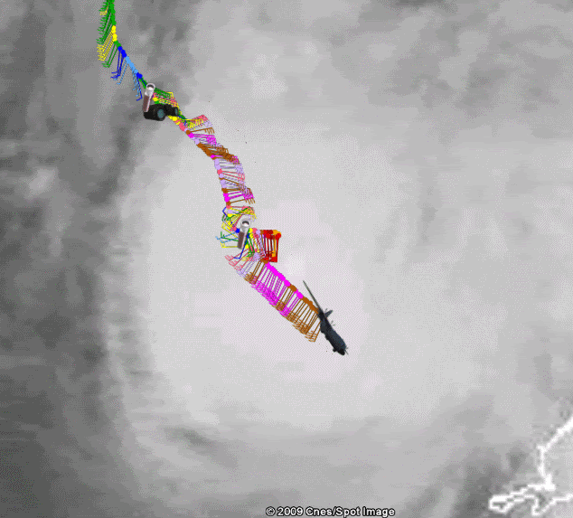
I think I was right...their center fix 24.4 N and 87.5 W
at 12 z in the morning its supposed to be at 25.6, 87.5 W....
Current motion still 345 degrees...still moving NNW. UNless it turns due north now it will end up west of that soon.
at 12 z in the morning its supposed to be at 25.6, 87.5 W....
Current motion still 345 degrees...still moving NNW. UNless it turns due north now it will end up west of that soon.
0 likes
-
Stormcenter
- S2K Supporter

- Posts: 6689
- Joined: Wed Sep 03, 2003 11:27 am
- Location: Houston, TX
-
Dave

- Retired Staff

- Posts: 13442
- Age: 75
- Joined: Tue Aug 01, 2006 3:57 pm
- Location: Milan Indiana
- Contact:
URNT15 KNHC 090603
AF304 0611A IDA HDOB 17 20091109
055530 2334N 08637W 6962 03164 0071 +086 +016 204035 035 030 004 00
055600 2333N 08635W 6972 03153 0071 +086 +016 203035 036 032 001 00
055630 2332N 08634W 6966 03161 0074 +085 +016 200035 036 032 000 00
055700 2331N 08633W 6967 03161 0080 +083 +016 200034 035 031 002 00
055730 2330N 08632W 6971 03157 0079 +082 +016 200035 035 030 001 00
055800 2328N 08630W 6967 03163 0079 +083 +016 199035 036 029 002 00
055830 2327N 08629W 6966 03166 0079 +085 +016 201035 035 031 001 00
055900 2326N 08628W 6971 03160 0078 +085 +017 201036 037 029 002 00
055930 2325N 08626W 6965 03166 0078 +085 +017 201036 036 028 003 00
060000 2324N 08625W 6964 03167 0074 +089 +017 202036 036 028 003 00
060030 2323N 08624W 6971 03160 0077 +090 +018 197036 036 028 004 00
060100 2322N 08622W 6962 03174 0079 +087 +018 193036 038 027 004 00
060130 2320N 08621W 6965 03170 0082 +085 +018 196037 038 026 003 00
060200 2319N 08620W 6970 03165 0081 +087 +017 196037 037 026 003 00
060230 2318N 08619W 6963 03170 0083 +086 +017 199037 038 027 003 00
060300 2317N 08617W 6966 03170 0092 +079 +017 199037 038 026 003 00
060330 2316N 08616W 6969 03168 0093 +079 +016 200038 038 028 001 00
060400 2315N 08615W 6962 03173 0092 +080 +016 201038 038 026 002 00
060430 2314N 08613W 6971 03163 0093 +080 +016 201038 038 025 002 00
060500 2313N 08612W 6965 03172 0092 +080 +016 203038 038 025 002 00
$$
;
0 likes
-
Stormcenter
- S2K Supporter
- Posts: 6689
- Joined: Wed Sep 03, 2003 11:27 am
- Location: Houston, TX
Re: ATL : HURRICANE IDA
I believe it may be actually doing that (moving north) now.
PTPatrick wrote:I think I was right...their center fix 24.4 N and 87.5 W
at 12 z in the morning its supposed to be at 25.6, 87.5 W....
Current motion still 345 degrees...still moving NNW. UNless it turns due north now it will end up west of that soon.
0 likes


Re: ATL : HURRICANE IDA
PTPatrick wrote:I think I was right...their center fix 24.4 N and 87.5 W
at 12 z in the morning its supposed to be at 25.6, 87.5 W....
Current motion still 345 degrees...still moving NNW. UNless it turns due north now it will end up west of that soon.
Just for reference - Pensacola is about 87.1
0 likes
-
Dave
- Retired Staff
- Posts: 13442
- Age: 75
- Joined: Tue Aug 01, 2006 3:57 pm
- Location: Milan Indiana
- Contact:
000
URNT12 KNHC 090610
VORTEX DATA MESSAGE AL112009
A. 09/05:33:50Z
B. 24 deg 23 min N
087 deg 27 min W
C. 700 mb 3037 m
D. 60 kt
E. 298 deg 6 nm
F. 179 deg 63 kt
G. 084 deg 14 nm
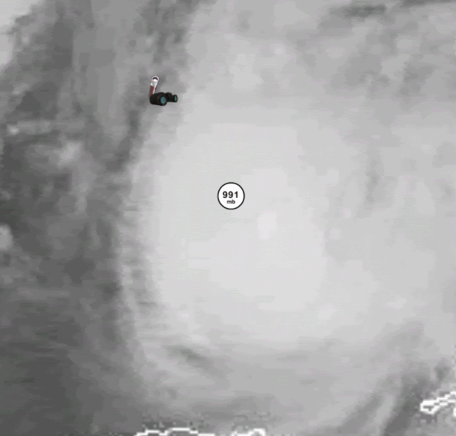
H. 991 mb
I. 13 C / 3057 m
J. 16 C / 3038 m
K. 3 C / NA
L. NA
M. NA
N. 1345 / 7
O. 0.02 / 3 nm
P. AF304 0611A IDA OB 05
MAX FL WIND 63 KT E QUAD 05:27:00Z
MAX FL TEMP 18C 6NM FROM FL CNTR
MIN SLP 988MB 6NM FROM FL CNTR
;
URNT12 KNHC 090610
VORTEX DATA MESSAGE AL112009
A. 09/05:33:50Z
B. 24 deg 23 min N
087 deg 27 min W
C. 700 mb 3037 m
D. 60 kt
E. 298 deg 6 nm
F. 179 deg 63 kt
G. 084 deg 14 nm
H. 991 mb
I. 13 C / 3057 m
J. 16 C / 3038 m
K. 3 C / NA
L. NA
M. NA
N. 1345 / 7
O. 0.02 / 3 nm
P. AF304 0611A IDA OB 05
MAX FL WIND 63 KT E QUAD 05:27:00Z
MAX FL TEMP 18C 6NM FROM FL CNTR
MIN SLP 988MB 6NM FROM FL CNTR
;
0 likes
-
Dave
- Retired Staff
- Posts: 13442
- Age: 75
- Joined: Tue Aug 01, 2006 3:57 pm
- Location: Milan Indiana
- Contact:
URNT15 KNHC 090613
AF304 0611A IDA HDOB 18 20091109
060530 2311N 08611W 6963 03175 0091 +080 +016 202038 038 026 002 00
060600 2310N 08610W 6969 03169 0090 +085 +017 199038 039 025 002 00
060630 2309N 08608W 6962 03181 0090 +085 +017 200038 039 024 003 00
060700 2308N 08607W 6970 03172 0090 +085 +017 200038 039 026 002 00
060730 2307N 08606W 6967 03174 0089 +086 +018 200038 039 024 002 00
060800 2306N 08604W 6969 03172 0091 +085 +018 198039 039 025 001 00
060830 2305N 08603W 6961 03193 0099 +087 +018 199039 039 999 999 03
060900 2306N 08601W 6973 03180 0102 +085 +018 192039 040 999 999 03
060930 2308N 08602W 6980 03161 0094 +085 +019 191039 040 020 003 03
061000 2310N 08602W 6966 03175 0088 +085 +019 192040 040 025 003 00
061030 2312N 08602W 6967 03171 0089 +085 +017 192041 041 028 003 00
061100 2314N 08602W 6966 03175 0086 +085 +016 193041 042 028 002 00
061130 2316N 08602W 6969 03174 0090 +085 +015 191042 042 029 002 00
061200 2319N 08602W 6967 03170 0094 +081 +015 191043 043 029 002 00
061230 2321N 08602W 6966 03175 0092 +082 +014 191043 043 029 003 00
061300 2323N 08602W 6967 03172 0094 +080 +014 191043 043 030 002 00
061330 2325N 08602W 6966 03174 0091 +081 +014 190043 043 030 002 00
061400 2327N 08602W 6967 03170 0095 +080 +014 190043 043 031 002 00
061430 2329N 08602W 6967 03171 0093 +081 +014 190042 043 030 002 00
061500 2331N 08603W 6967 03171 0089 +083 +014 188042 043 032 001 00
$$
;
0 likes
-
Dave
- Retired Staff
- Posts: 13442
- Age: 75
- Joined: Tue Aug 01, 2006 3:57 pm
- Location: Milan Indiana
- Contact:
Product: Air Force Vortex Message (URNT12 KNHC)
Transmitted: 9th day of the month at 06:10Z
Aircraft: Air Force Aircraft (Last 3 digits of the tail number are 304)
Storm Number & Year: 11L in 2009
Storm Name: Ida (flight in the North Atlantic basin)
Mission Number: 6
Observation Number: 05
A. Time of Center Fix: 9th day of the month at 5:33:50Z
B. Center Fix Coordinates: 24°23'N 87°27'W (24.3833N 87.45W)
B. Center Fix Location: 357 miles (574 km) to the W (268°) from Key West, FL, USA.
C. Minimum Height at Standard Level: 3,037m (9,964ft) at 700mb
D. Estimated (by SFMR or visually) Maximum Surface Wind: 60kts (~ 69.0mph)
E. Location of the Estimated Maximum Surface Wind: 6 nautical miles (7 statute miles) to the WNW (298°) of center fix
F. Maximum Flight Level Wind Inbound: From 179° at 63kts (From the S at ~ 72.5mph)
G. Location of Maximum Flight Level Wind Inbound: 14 nautical miles (16 statute miles) to the E (84°) of center fix
H. Minimum Sea Level Pressure: 991mb (29.26 inHg)
I. Maximum Flight Level Temp & Pressure Altitude Outside Eye: 13°C (55°F) at a pressure alt. of 3,057m (10,030ft)
J. Maximum Flight Level Temp & Pressure Altitude Inside Eye: 16°C (61°F) at a pressure alt. of 3,038m (9,967ft)
K. Dewpoint Temp (collected at same location as temp inside eye): 3°C (37°F)
K. Sea Surface Temp (collected at same location as temp inside eye): Not Available
L. Eye Character: Not Available
M. Eye Shape: Not Available
N. Fix Determined By: Penetration, Wind, Pressure and Temperature
N. Fix Level: 700mb
O. Navigation Fix Accuracy: 0.02 nautical miles
O. Meteorological Accuracy: 3 nautical miles
Remarks Section - Remarks That Were Decoded...
Maximum Flight Level Wind: 63kts (~ 72.5mph) in the east quadrant at 5:27:00Z
Remarks Section - Additional Remarks...
MAX FL TEMP 18C 6NM FROM FL CNTR
MIN SLP 988MB 6NM FROM FL CNTR
0 likes
Re: ATL : HURRICANE IDA
It looks terrible... I'm starting to think this will be a landfalling tropical storm.
0 likes
-
Kingarabian

- S2K Supporter
- Posts: 16381
- Joined: Sat Aug 08, 2009 3:06 am
- Location: Honolulu, Hawaii

-
IvanSurvivor
- Tropical Storm

- Posts: 152
- Joined: Wed Aug 20, 2008 12:12 am
- Location: Pensacola Florida (Warrington)
Re: ATL : HURRICANE IDA
Based on the recon data from this trip, does anyone think this system may have weakened below hurricane strength? Obviously they haven't sampled everything, but the east side wasn't even that impressive. I wonder what NHC will do at 3AM.
0 likes
-
deltadog03

- Professional-Met

- Posts: 3580
- Joined: Tue Jul 05, 2005 6:16 pm
- Location: Macon, GA
-
Dave
- Retired Staff
- Posts: 13442
- Age: 75
- Joined: Tue Aug 01, 2006 3:57 pm
- Location: Milan Indiana
- Contact:
Product: Air Force Tropical RECCO Message (URNT11 KNHC)
Transmitted: 9th day of the month at 06:11Z
Aircraft: Air Force Aircraft (Last 3 digits of the tail number are 304)
Storm Number: 11
Storm Name: Ida (flight in the North Atlantic basin)
Mission Number: 6
Observation Number: 07
Mandatory Data...
Observation Time: Monday, 6:08Z
Radar Capability: Yes
Aircraft Altitude: Below 10,000 meters
Coordinates: 23.1N 86.1W
Location: 291 miles (469 km) to the WSW (250°) from Key West, FL, USA.
Turbulence: None
Conditions Along Flight Route: In the clear
Pressure Altitude: 3,050 meters
Flight Level Wind: From 200° at 39 knots (From the SSW at ~ 44.8 mph)
- The above is a spot wind.
- Winds were obtained using doppler radar or inertial systems.
Flight Level Temperature: 9°C
Flight Level Dew Point: 2°C
Weather (within 30 nautical miles): Thunderstorm(s)
700 mb Surface Altitude: 3,136 geopotential meters
Remarks Section - Remarks That Were Decoded...
Surface Wind Speed (likely by SFMR): 25 knots (~ 28.8mph)
Remarks Section - Additional Remarks...
SE EXIT PT
0 likes
-
Dave
- Retired Staff
- Posts: 13442
- Age: 75
- Joined: Tue Aug 01, 2006 3:57 pm
- Location: Milan Indiana
- Contact:
URNT15 KNHC 090623
AF304 0611A IDA HDOB 19 20091109
061530 2334N 08603W 6967 03170 0088 +083 +014 188042 043 031 003 00
061600 2336N 08603W 6966 03172 0086 +085 +014 189044 044 033 002 00
061630 2338N 08603W 6967 03168 0087 +085 +014 188045 045 033 003 00
061700 2340N 08603W 6967 03168 0087 +084 +015 187045 046 033 003 00
061730 2342N 08603W 6967 03170 0094 +078 +015 186045 045 034 002 00
061800 2344N 08603W 6969 03167 0099 +075 +015 184045 045 034 003 00
061830 2346N 08603W 6966 03169 0098 +075 +014 183045 046 035 003 00
061900 2349N 08603W 6966 03173 0091 +079 +014 184046 047 036 001 00
061930 2351N 08603W 6968 03169 0086 +082 +015 184047 047 035 002 00
062000 2353N 08603W 6969 03166 0090 +079 +016 182047 047 037 002 00
062030 2355N 08603W 6967 03169 0096 +075 +016 181046 047 037 003 00
062100 2357N 08603W 6961 03172 0100 +072 +016 179047 050 036 005 00
062130 2400N 08603W 6970 03164 0097 +075 +015 178045 046 036 001 00
062200 2402N 08603W 6967 03169 0097 +075 +015 175045 045 039 004 00
062230 2404N 08603W 6967 03168 0093 +076 +015 179047 047 042 004 00
062300 2406N 08603W 6939 03199 0112 +063 +015 179051 053 042 010 00
062330 2408N 08603W 6970 03163 0096 +074 +013 180051 053 041 002 00
062400 2411N 08603W 6963 03172 0095 +074 +011 178051 053 040 003 00
062430 2413N 08603W 6967 03166 0094 +075 +010 178049 051 038 005 00
062500 2415N 08603W 6968 03164 0096 +072 +010 173050 052 037 004 00
$$
;
0 likes
Who is online
Users browsing this forum: No registered users and 50 guests