ATL : TROPICAL DEPRESSION IDA

Moderator: S2k Moderators

Message
Author
Brent
S2K Supporter
S2K Supporter
Posts: 38089
Age: 36
Joined: Sun May 16, 2004 10:30 pm
Location: Tulsa Oklahoma
Contact:

Re: ATL : TROPICAL STORM IDA

#3821 Postby Brent » Mon Nov 09, 2009 12:30 pm

attallaman wrote:Does that look like a feeder band approaching Mobile? Pensacola looks like it's getting feeder band activity right now. What's Ida's winds down to? Less than 70?


Officially at 70 but I suspect it's a bit lower.

and yes, that is a feeder band.
0 likes   
#neversummer

User avatar
TheEuropean
Professional-Met
Professional-Met
Posts: 1796
Age: 59
Joined: Tue Sep 20, 2005 3:17 pm
Location: Voerde, Germany
Contact:

#3822 Postby TheEuropean » Mon Nov 09, 2009 12:30 pm

000
URNT15 KNHC 091718
AF303 0711A IDA HDOB 06 20091109
171030 2821N 08942W 8425 01565 0114 +128 +128 069038 039 040 006 00
171100 2820N 08941W 8433 01559 0114 +129 +129 068039 042 039 003 00
171130 2819N 08940W 8429 01559 0112 +129 +129 068039 040 040 002 00
171200 2818N 08939W 8429 01560 0110 +131 +129 066037 037 040 004 00
171230 2817N 08938W 8430 01558 0109 +131 +126 067039 039 041 004 00
171300 2816N 08936W 8428 01558 0106 +133 +130 067038 039 040 004 00
171330 2815N 08935W 8430 01554 0102 +140 +115 066036 036 044 001 00
171400 2814N 08934W 8425 01559 0099 +141 +119 065035 035 043 003 00
171430 2813N 08933W 8429 01555 0098 +142 +117 064034 035 039 002 00
171500 2811N 08931W 8432 01549 0093 +148 +107 061032 033 041 003 00
171530 2810N 08930W 8430 01550 0092 +150 +104 063030 030 043 002 00
171600 2809N 08929W 8429 01554 0093 +148 +108 059027 028 042 002 00
171630 2808N 08928W 8426 01555 0093 +145 +116 055026 026 040 003 00
171700 2807N 08926W 8430 01549 0088 +153 +113 056026 026 041 004 00
171730 2806N 08925W 8430 01548 0085 +155 +121 060028 028 040 004 00
171800 2805N 08924W 8429 01551 0081 +161 +119 060029 030 041 005 00
171830 2804N 08923W 8432 01546 0079 +164 +115 056027 030 044 005 00
171900 2803N 08921W 8428 01549 0078 +165 +126 050032 033 045 008 00
171930 2801N 08920W 8432 01547 0081 +158 +137 052033 034 045 008 00
172000 2800N 08919W 8427 01551 0087 +149 +139 049033 035 044 011 00
$$
0 likes   

User avatar
Ivanhater
Storm2k Moderator
Storm2k Moderator
Posts: 11161
Age: 38
Joined: Fri Jul 01, 2005 8:25 am
Location: Pensacola

Re: ATL : TROPICAL STORM IDA

#3823 Postby Ivanhater » Mon Nov 09, 2009 12:31 pm

Image
0 likes   
Michael

User avatar
wxman57
Moderator-Pro Met
Moderator-Pro Met
Posts: 22978
Age: 67
Joined: Sat Jun 21, 2003 8:06 pm
Location: Houston, TX (southwest)

Re: ATL : TROPICAL STORM IDA

#3824 Postby wxman57 » Mon Nov 09, 2009 12:34 pm

1630Z HRD Ida wind analysis map up. Peak wind 53 kts in two tiny areas:

ftp://ftp.aoml.noaa.gov/hrd/pub/hwind/2 ... tour04.png
0 likes   

User avatar
brunota2003
S2K Supporter
S2K Supporter
Posts: 9476
Age: 34
Joined: Sat Jul 30, 2005 9:56 pm
Location: Stanton, KY...formerly Havelock, NC
Contact:

#3825 Postby brunota2003 » Mon Nov 09, 2009 12:35 pm

They're close. The 9 am advisory had the location at 26.5N and 88.3W...recon is currently at 28.0N and 89.2W...should begin descent here within the next couple ob sets I would think.
0 likes   

User avatar
HURAKAN
Professional-Met
Professional-Met
Posts: 46086
Age: 38
Joined: Thu May 20, 2004 4:34 pm
Location: Key West, FL
Contact:

#3826 Postby HURAKAN » Mon Nov 09, 2009 12:36 pm

Image
0 likes   

User avatar
HURAKAN
Professional-Met
Professional-Met
Posts: 46086
Age: 38
Joined: Thu May 20, 2004 4:34 pm
Location: Key West, FL
Contact:

#3827 Postby HURAKAN » Mon Nov 09, 2009 12:38 pm

Image
0 likes   

User avatar
TheEuropean
Professional-Met
Professional-Met
Posts: 1796
Age: 59
Joined: Tue Sep 20, 2005 3:17 pm
Location: Voerde, Germany
Contact:

#3828 Postby TheEuropean » Mon Nov 09, 2009 12:38 pm

000
URNT15 KNHC 091728
AF303 0711A IDA HDOB 07 20091109
172030 2759N 08917W 8429 01549 0086 +150 +139 044036 037 044 010 00
172100 2758N 08916W 8430 01546 0085 +147 +142 044037 038 044 006 00
172130 2757N 08915W 8428 01546 0084 +144 +143 044037 038 044 005 00
172200 2756N 08914W 8432 01540 0083 +141 +141 044040 041 045 006 00
172230 2755N 08912W 8429 01539 0082 +137 +137 043044 045 045 007 00
172300 2754N 08911W 8430 01536 0081 +136 +136 045046 047 046 009 00
172330 2752N 08910W 8429 01534 0080 +133 +133 044047 048 046 012 00
172400 2751N 08908W 8430 01531 0076 +135 +135 043050 051 048 012 00
172430 2750N 08907W 8434 01527 0075 +133 +133 046051 052 047 013 00
172500 2749N 08906W 8424 01533 0076 +128 +128 044053 054 047 013 00
172530 2748N 08905W 8429 01529 0075 +127 +127 045050 051 045 013 00
172600 2747N 08903W 8430 01525 0069 +132 +132 044048 049 048 010 00
172630 2746N 08902W 8429 01522 0063 +139 +139 044047 047 051 011 00
172700 2745N 08901W 8430 01519 0065 +130 +130 048045 046 054 025 01
172730 2743N 08859W 8428 01520 9990 +134 +999 051037 041 057 027 01
172800 2742N 08858W 8436 01511 9990 +127 +999 046040 042 050 034 01
172830 2741N 08857W 8424 01529 9990 +123 +999 034038 040 049 028 01
172900 2740N 08856W 8423 01529 9990 +113 +999 029043 044 049 020 05
172930 2740N 08854W 8431 01514 9990 +113 +999 040047 048 055 026 01
173000 2739N 08852W 8431 01510 9990 +116 +999 039046 047 053 025 01
$$
0 likes   

User avatar
deltadog03
Professional-Met
Professional-Met
Posts: 3580
Joined: Tue Jul 05, 2005 6:16 pm
Location: Macon, GA

#3829 Postby deltadog03 » Mon Nov 09, 2009 12:39 pm

27.7 88.2?? right around there
0 likes   

User avatar
brunota2003
S2K Supporter
S2K Supporter
Posts: 9476
Age: 34
Joined: Sat Jul 30, 2005 9:56 pm
Location: Stanton, KY...formerly Havelock, NC
Contact:

#3830 Postby brunota2003 » Mon Nov 09, 2009 12:39 pm

Guess they are already at operational altitude :lol: 57 knot surface wind

Also, the bird seems to be having issues regarding pressure readings, ever since takeoff
0 likes   

Dean4Storms
S2K Supporter
S2K Supporter
Posts: 6358
Age: 62
Joined: Sun Aug 31, 2003 1:01 pm
Location: Miramar Bch. FL

#3831 Postby Dean4Storms » Mon Nov 09, 2009 12:40 pm

Looks to be more of a due N movement now.
0 likes   

User avatar
HURAKAN
Professional-Met
Professional-Met
Posts: 46086
Age: 38
Joined: Thu May 20, 2004 4:34 pm
Location: Key West, FL
Contact:

#3832 Postby HURAKAN » Mon Nov 09, 2009 12:43 pm

Image
0 likes   

jconsor
Professional-Met
Professional-Met
Posts: 551
Joined: Mon Jun 30, 2008 9:31 pm
Location: Jerusalem, Israel
Contact:

Re: ATL : TROPICAL STORM IDA

#3833 Postby jconsor » Mon Nov 09, 2009 12:44 pm

According to the HRD analysis, surge is a greater threat than wind, due to the large area of TS force winds:

Destruction Potential Rating (0-6):
Wind: 0.6
Surge/Waves: 1.9
0 likes   

User avatar
deltadog03
Professional-Met
Professional-Met
Posts: 3580
Joined: Tue Jul 05, 2005 6:16 pm
Location: Macon, GA

#3834 Postby deltadog03 » Mon Nov 09, 2009 12:44 pm

Looks like highest FL that pass was 73kts. extrap pressure 991.4mb
0 likes   

User avatar
TheEuropean
Professional-Met
Professional-Met
Posts: 1796
Age: 59
Joined: Tue Sep 20, 2005 3:17 pm
Location: Voerde, Germany
Contact:

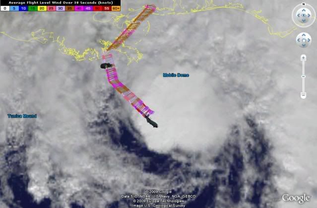
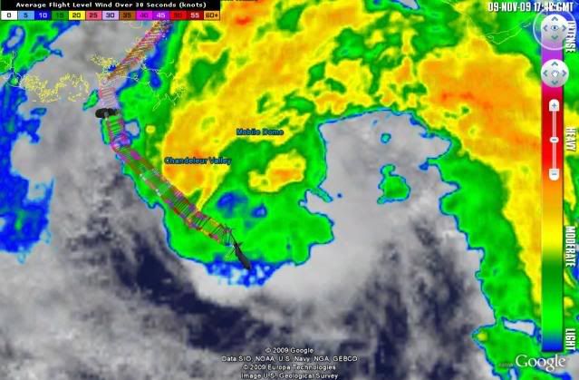
#3835 Postby TheEuropean » Mon Nov 09, 2009 12:45 pm

000
URNT15 KNHC 091738
AF303 0711A IDA HDOB 08 20091109
173030 2738N 08851W 8428 01506 9990 +113 +999 025053 056 052 020 01
173100 2738N 08849W 8432 01500 9990 +111 +999 040058 062 055 020 01
173130 2737N 08848W 8420 01500 9990 +113 +999 038063 066 054 017 01
173200 2736N 08846W 8425 01495 9990 +117 +999 038071 073 050 015 01
173230 2735N 08845W 8434 01480 9990 +126 +999 043068 070 052 010 01
173300 2735N 08844W 8416 01497 9990 +122 +999 041067 068 054 010 01
173330 2734N 08842W 8430 01477 9990 +132 +999 044056 059 052 009 01
173400 2733N 08841W 8422 01479 9990 +142 +999 049051 054 053 007 01
173430 2733N 08839W 8426 01471 9981 +159 +159 051043 047 053 005 00
173500 2732N 08838W 8436 01453 9976 +163 +163 050040 042 054 006 03
173530 2731N 08837W 8425 01459 9990 +156 +999 048036 041 056 005 01
173600 2730N 08836W 8428 01450 9954 +167 +167 041027 034 056 003 05
173630 2729N 08834W 8428 01447 9940 +188 +179 013016 017 051 003 03
173700 2728N 08832W 8432 01439 9932 +198 +167 002016 017 048 002 03
173730 2728N 08831W 8434 01428 9921 +206 +163 003014 015 044 003 00
173800 2728N 08829W 8428 01432 9918 +204 +163 012012 015 032 002 00
173830 2727N 08827W 8433 01426 9921 +193 +172 003008 011 026 003 00
173900 2727N 08825W 8430 01427 9915 +204 +165 219003 009 027 000 00
173930 2727N 08823W 8429 01427 9910 +213 +158 214011 013 023 003 03
174000 2726N 08822W 8431 01426 9913 +209 +160 223022 024 028 000 00
$$

73 kts at flight level
0 likes   

kevin

Re: ATL : TROPICAL STORM IDA

#3836 Postby kevin » Mon Nov 09, 2009 12:47 pm

What is the chance of this system moving eastward just off the coast all the way to the Big Bend?
0 likes   

Dean4Storms
S2K Supporter
S2K Supporter
Posts: 6358
Age: 62
Joined: Sun Aug 31, 2003 1:01 pm
Location: Miramar Bch. FL

#3837 Postby Dean4Storms » Mon Nov 09, 2009 12:50 pm

73kts at flight level and pressure trending down. Sounds like some slight strengthening too me!!

What would that translate to the surface as?? 70mph?
0 likes   

jconsor
Professional-Met
Professional-Met
Posts: 551
Joined: Mon Jun 30, 2008 9:31 pm
Location: Jerusalem, Israel
Contact:

Re: ATL : TROPICAL STORM IDA

#3838 Postby jconsor » Mon Nov 09, 2009 12:51 pm

Looks like Ida has strengthened slightly since the last recon pass. Extrapolated pressure is down 3 mb from the last recon (11z). Flight-level winds are up significantly vs. the 11z recon - 73 kt vs. 60 kt. Also peak SFMR winds are 57 kt vs. 48 kt on last recon.
0 likes   

kevin

#3839 Postby kevin » Mon Nov 09, 2009 12:52 pm

Does the strength of this system have an influence on track?
0 likes   

User avatar
wxman57
Moderator-Pro Met
Moderator-Pro Met
Posts: 22978
Age: 67
Joined: Sat Jun 21, 2003 8:06 pm
Location: Houston, TX (southwest)

Re:

#3840 Postby wxman57 » Mon Nov 09, 2009 12:54 pm

Dean4Storms wrote:73kts at flight level and pressure trending down. Sounds like some slight strengthening too me!!

What would that translate to the surface as?? 70mph?


The strengthening looks temporary. Once the squalls decline it'll be hard for Ida to translate those FL winds to the surface. Probably a moderate TS at landfall (50-55 mph winds in a very small area).
0 likes   


Return to “2009”

Who is online

Users browsing this forum: No registered users and 2 guests