ATL : TROPICAL DEPRESSION IDA
Moderator: S2k Moderators
-
tolakram
- Admin

- Posts: 20186
- Age: 62
- Joined: Sun Aug 27, 2006 8:23 pm
- Location: Florence, KY (name is Mark)
Re: ATL : TROPICAL STORM IDA
The center, I think, is now visible. Keep in mind this is way up there due to distance.

0 likes
M a r k
- - - - -
Join us in chat: Storm2K Chatroom Invite. Android and IOS apps also available.
The posts in this forum are NOT official forecasts and should not be used as such. Posts are NOT endorsed by any professional institution or STORM2K.org. For official information and forecasts, please refer to NHC and NWS products.
-
Dean4Storms
- S2K Supporter

- Posts: 6358
- Age: 63
- Joined: Sun Aug 31, 2003 1:01 pm
- Location: Miramar Bch. FL
-
HURAKAN

- Professional-Met

- Posts: 46084
- Age: 39
- Joined: Thu May 20, 2004 4:34 pm
- Location: Key West, FL
- Contact:
URNT12 KNHC 091813
VORTEX DATA MESSAGE AL112009
A. 09/17:39:00Z
B. 27 deg 27 min N
088 deg 25 min W
C. 850 mb 1357 m
D. 57 kt
E. 295 deg 34 nm
F. 035 deg 72 kt
G. 293 deg 20 nm
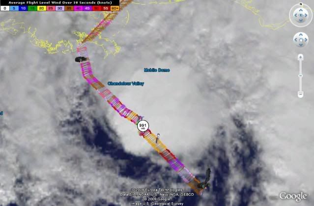
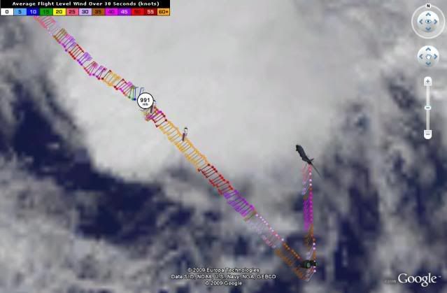
H. 991 mb
I. 13 C / 1520 m
J. 22 C / 1523 m
K. 16 C / NA
L. POORLY DEFINED
M. E07/32/16
N. 12345 / 8
O. 0.02 / 1 nm
P. AF303 0711A IDA OB 05
MAX FL WIND 73 KT NW QUAD 17:32:00Z
MAX FL TEMP 23 C 129 / 18 NM FROM FL CNTR
VORTEX DATA MESSAGE AL112009
A. 09/17:39:00Z
B. 27 deg 27 min N
088 deg 25 min W
C. 850 mb 1357 m
D. 57 kt
E. 295 deg 34 nm
F. 035 deg 72 kt
G. 293 deg 20 nm
H. 991 mb
I. 13 C / 1520 m
J. 22 C / 1523 m
K. 16 C / NA
L. POORLY DEFINED
M. E07/32/16
N. 12345 / 8
O. 0.02 / 1 nm
P. AF303 0711A IDA OB 05
MAX FL WIND 73 KT NW QUAD 17:32:00Z
MAX FL TEMP 23 C 129 / 18 NM FROM FL CNTR
0 likes
-
Derek Ortt
-
stormcloud
- Professional-Met
- Posts: 130
- Joined: Fri May 07, 2004 2:44 pm
- Location: Houston
Re: ATL : TROPICAL STORM IDA - Recon
From latest vortex msg
Estimated (by SFMR or visually) Maximum Surface Wind: 57kts (~ 65.6mph)
Estimated (by SFMR or visually) Maximum Surface Wind: 57kts (~ 65.6mph)
0 likes
-
Sabanic

- Category 2

- Posts: 683
- Age: 66
- Joined: Wed Aug 01, 2007 7:01 am
- Location: Mobile, AL
- Contact:
Re: ATL : TROPICAL STORM IDA
Are we sure it's November? This is just plain crazy!
0 likes
"I can do all things through Christ which strengtheneth me" - Philippians 4:13
-
Aric Dunn
- Category 5

- Posts: 21238
- Age: 43
- Joined: Sun Sep 19, 2004 9:58 pm
- Location: Ready for the Chase.
- Contact:
Re: ATL : TROPICAL STORM IDA - Recon
stormcloud wrote:From latest vortex msg
Estimated (by SFMR or visually) Maximum Surface Wind: 57kts (~ 65.6mph)
I'll go with that ..
0 likes
-
TheEuropean

- Professional-Met
- Posts: 1797
- Age: 60
- Joined: Tue Sep 20, 2005 3:17 pm
- Location: Voerde, Germany
- Contact:
000
URNT15 KNHC 091818
AF303 0711A IDA HDOB 12 20091109
181030 2625N 08716W 8429 01555 0085 +161 +151 222030 030 031 001 00
181100 2624N 08715W 8429 01553 0086 +160 +155 224029 031 032 000 00
181130 2623N 08713W 8430 01556 0086 +162 +153 225032 033 030 000 00
181200 2621N 08712W 8429 01557 0086 +165 +151 223035 036 029 002 00
181230 2620N 08711W 8429 01558 0084 +165 +149 223036 036 030 001 00
181300 2619N 08710W 8430 01557 0085 +165 +149 224038 038 031 000 00
181330 2618N 08708W 8430 01558 0087 +165 +145 224037 038 029 001 00
181400 2617N 08707W 8428 01561 0089 +165 +142 223039 039 029 001 00
181430 2616N 08706W 8426 01563 0088 +167 +142 223037 039 028 002 00
181500 2615N 08705W 8429 01560 0088 +169 +140 222038 038 026 002 00
181530 2613N 08703W 8429 01563 0090 +164 +143 222037 038 028 001 00
181600 2612N 08702W 8428 01566 0090 +166 +145 220035 035 026 001 00
181630 2611N 08701W 8430 01564 0093 +164 +147 219035 035 027 002 00
181700 2610N 08700W 8429 01564 0094 +165 +147 220036 036 027 000 00
181730 2609N 08658W 8433 01565 0097 +166 +139 219035 035 024 002 03
181800 2609N 08657W 8430 01568 0099 +165 +143 213034 034 999 999 03
181830 2611N 08657W 8428 01568 0094 +166 +140 211032 033 023 001 03
181900 2613N 08657W 8418 01577 0093 +166 +137 208033 033 028 000 00
181930 2615N 08657W 8433 01563 0095 +167 +138 205035 035 030 000 00
182000 2617N 08657W 8433 01560 0095 +165 +142 205036 036 030 000 00
$$
0 likes

-
MGC

- S2K Supporter
- Posts: 5941
- Joined: Sun Mar 23, 2003 9:05 pm
- Location: Pass Christian MS, or what is left.
Re: ATL : TROPICAL STORM IDA
Radar eye is likely well displaced from the surface center due to shear.....MGC
0 likes
-
deltadog03

- Professional-Met
- Posts: 3580
- Joined: Tue Jul 05, 2005 6:16 pm
- Location: Macon, GA
-
tolakram
- Admin
- Posts: 20186
- Age: 62
- Joined: Sun Aug 27, 2006 8:23 pm
- Location: Florence, KY (name is Mark)
Re: ATL : TROPICAL STORM IDA
0 likes
M a r k
- - - - -
Join us in chat: Storm2K Chatroom Invite. Android and IOS apps also available.
The posts in this forum are NOT official forecasts and should not be used as such. Posts are NOT endorsed by any professional institution or STORM2K.org. For official information and forecasts, please refer to NHC and NWS products.
- - - - -
Join us in chat: Storm2K Chatroom Invite. Android and IOS apps also available.
The posts in this forum are NOT official forecasts and should not be used as such. Posts are NOT endorsed by any professional institution or STORM2K.org. For official information and forecasts, please refer to NHC and NWS products.
-
Aric Dunn
- Category 5
- Posts: 21238
- Age: 43
- Joined: Sun Sep 19, 2004 9:58 pm
- Location: Ready for the Chase.
- Contact:
Re: ATL : TROPICAL STORM IDA
MGC wrote:Radar eye is likely well displaced from the surface center due to shear.....MGC
yeah I just calculated the vortex fix for the center with that radar and its like 4 miles displaced..
0 likes

-
TheEuropean
- Professional-Met
- Posts: 1797
- Age: 60
- Joined: Tue Sep 20, 2005 3:17 pm
- Location: Voerde, Germany
- Contact:
000
URNT15 KNHC 091828
AF303 0711A IDA HDOB 13 20091109
182030 2619N 08657W 8430 01563 0093 +166 +143 206034 035 028 002 00
182100 2621N 08657W 8429 01562 0090 +170 +140 205034 035 030 000 00
182130 2623N 08657W 8430 01561 0089 +170 +140 204035 036 030 001 00
182200 2625N 08658W 8433 01557 0087 +170 +139 203037 038 030 001 00
182230 2627N 08658W 8429 01561 0085 +175 +130 200038 039 032 000 00
182300 2629N 08658W 8429 01562 0087 +172 +133 202039 040 033 000 00
182330 2632N 08658W 8426 01563 0087 +170 +136 203040 041 033 000 00
182400 2634N 08658W 8430 01559 0087 +170 +138 201040 040 032 002 00
182430 2636N 08658W 8430 01561 0087 +169 +140 202040 041 032 001 00
182500 2638N 08658W 8422 01568 0087 +168 +141 201041 041 033 000 00
182530 2640N 08658W 8433 01557 0088 +165 +142 202042 042 032 002 00
182600 2642N 08658W 8430 01560 0088 +169 +140 203042 043 032 000 00
182630 2644N 08658W 8430 01559 0088 +166 +145 203040 040 034 000 00
182700 2646N 08658W 8429 01561 0088 +167 +146 205037 040 033 000 00
182730 2648N 08658W 8433 01555 0086 +166 +149 213032 033 033 000 00
182800 2650N 08658W 8429 01562 0083 +172 +144 208031 032 035 000 00
182830 2653N 08658W 8429 01558 0083 +172 +144 207030 031 035 000 00
182900 2655N 08658W 8428 01559 0080 +175 +141 204028 028 036 000 00
182930 2657N 08658W 8429 01558 0079 +179 +136 203028 028 035 001 00
183000 2659N 08659W 8430 01557 0075 +184 +123 204029 030 034 000 00
$$
0 likes
Who is online
Users browsing this forum: No registered users and 30 guests