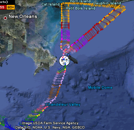
That's 997 mb in the coc.
Moderator: S2k Moderators


Dean4Storms wrote:Going to be impossible to track the center on radar from this point I believe, she is a mess!


Derek Ortt wrote:Dean4Storms wrote:From the NWS in Mobile.
.STORM INFORMATION...
AT 7 PM CST...THE CENTER OF TROPICAL STORM IDA WAS LOCATED NEAR
LATITUDE 29.4 NORTH...LONGITUDE 88.4 WEST...OR ABOUT 55 MILES SOUTH
DAUPHIN ISLAND ALABAMA. RADAR INDICATES THE ESTIMATED RATE OF MOTION
IS TO THE NORTH-NORTHEAST AT 19 MPH.
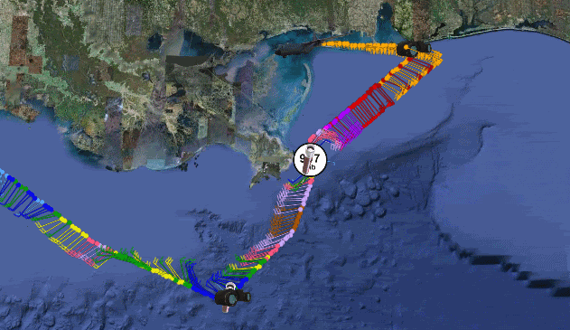
the NWS position does not match the aircraft position at all. The center is closer to 88.8W now. Actually has moved to the NW.
I think we have seen this totally decouple


wxman57 wrote:Derek Ortt wrote:the NWS position does not match the aircraft position at all. The center is closer to 88.8W now. Actually has moved to the NW.
I think we have seen this totally decouple
Just looked at a sat pic. Is that the center completely exposed just SE of the mouth of the MS? Surface obs support it. If it is, then it may well never make landfall. New VDM has a fix at 29.1N/88.8W. That's the open swirl on the sat pic below. In addition, looks like cool air stratocumulus flowing into it from the west (that solid light gray cloud mass all along the LA coast to the upper TX coast). Getting cool here in Houston. Have been seeing reports of very strong northerly winds off the mid LA coast this afternoon and evening (our clients). Clearly, cool air is racing out across the Gulf just west of Ida.
No flooding reported in my county, Harrison but the county to my west bordering LA, Hancock county has had flooding in low lying areas, evacuations were underway in a few areas in Hancock county a few hours ago but I'll say this, the winds are really picking up now here in west Biloxi, it's beginning to sound like TS Bill outside here tonight. I read on WWL TV4 on Twitter that Ida is now down to 65 mph. Where is the NHC still projecting landfall? Mobile Bay area?bayoubebe wrote:attallaman wrote:Beginning to get a little more wind action here right now. Winds are out of the NNE at 24, gusting to 42. The rain seems to be tapering off for now.
Did you get flooding in your area? At the times, that I watched live reports with reporters in MS, AL, AND FL; MS looked like it was getting pounded the worst.
psyclone wrote:wxman57, your theory from days ago that there may be nothing to landfall may turn out to be dangerously accurate! the thing has imploded. interesting to note the best convection now resides off of SW florida in the juicy air and actually extends all the way past wrn cuba...that region has gotten alot of ida rains.


attallaman wrote:No flooding reported in my county, Harrison but the county to my west bordering LA, Hancock county has had flooding in low lying areas, evacuations were underway in a few areas in Hancock county a few hours ago but I'll say this, the winds are really picking up now here in west Biloxi, it's beginning to sound like TS Bill outside here tonight. I read on WWL TV4 on Twitter that Ida is now down to 65 mph. Where is the NHC still projecting landfall? Mobile Bay area?bayoubebe wrote:attallaman wrote:Beginning to get a little more wind action here right now. Winds are out of the NNE at 24, gusting to 42. The rain seems to be tapering off for now.
Did you get flooding in your area? At the times, that I watched live reports with reporters in MS, AL, AND FL; MS looked like it was getting pounded the worst.
wxman57 wrote:psyclone wrote:wxman57, your theory from days ago that there may be nothing to landfall may turn out to be dangerously accurate! the thing has imploded. interesting to note the best convection now resides off of SW florida in the juicy air and actually extends all the way past wrn cuba...that region has gotten alot of ida rains.
There's a reason why not too many TCs hit the U.S. in November, particularly west of Florida in the Gulf. I wonder if that low-level swirl will even move ashore? Doesn't really matter, though. Once the squalls to the north are inland, Ida's about dead.
ozonepete wrote:wxman57 wrote:psyclone wrote:wxman57, your theory from days ago that there may be nothing to landfall may turn out to be dangerously accurate! the thing has imploded. interesting to note the best convection now resides off of SW florida in the juicy air and actually extends all the way past wrn cuba...that region has gotten alot of ida rains.
There's a reason why not too many TCs hit the U.S. in November, particularly west of Florida in the Gulf. I wonder if that low-level swirl will even move ashore? Doesn't really matter, though. Once the squalls to the north are inland, Ida's about dead.
Your initial forecast, based on climo, was right.

Users browsing this forum: Google Adsense [Bot] and 33 guests