Appears a pattern change is coming for those that like colder weather. As of late the Polar Vortex has been anchored near Alaska which is rather uncommon and not favorable for Arctic Intrusions into North America. Long Range guidance is suggesting that things are about to change. Guidance has had a tough go of things for the past six weeks or so as the WPAC has been very active and a strong Jet Stream has been slamming the Pacific NW, while very strong low pressure systems have impacted the Gulf of Alaska Region. The coldest air has been bottled up in Siberian areas and no cross polar flow has been occurring. Canada infact has been rather warm climo wise, but there are changes ahead. It appears the Polar Vortex (PV) will shift east near a Thanksgiving time frame, moving across the Yukon Territories into Central Canada. This will allow some Arctic Air to enter North America via a cross Polar flow. High pressure appears to be building in the Aleutians/NW Pacific that will force the colder air into North America along/near the Rockies. Some things to watch for in the days and weeks ahead.
1. Storm systems in Canada diving S into the Plains States
2. Very strong storms in the Central Rockies with heavy snowfall
3. Active Sub Tropical Jet
4. Snow cover slowly building in Central and Southern Plains
5. Persistent Trough along the Rocky Mountain States/Plains
6. Low Pressure development along the Sub Tropical Jet in the W GOM
7. Phasing of the Northern and Southern jet streams periodically
8. Wintry precip starting effect North and Central TX in early December
All in all it does appear we are about to enter an active pattern and should make for interesting discussions in the days and weeks ahead IMHO.
Texas winter wx thread (2009-2010)
Moderator: S2k Moderators
Forum rules
 The posts in this forum are NOT official forecast and should not be used as such. They are just the opinion of the poster and may or may not be backed by sound meteorological data. They are NOT endorsed by any professional institution or STORM2K.

The posts in this forum are NOT official forecast and should not be used as such. They are just the opinion of the poster and may or may not be backed by sound meteorological data. They are NOT endorsed by any professional institution or STORM2K.
-
srainhoutx

- S2K Supporter

- Posts: 6919
- Age: 68
- Joined: Sun Jan 14, 2007 11:34 am
- Location: Haywood County, NC
- Contact:
Re: Texas winter wx thread (2009-2010)
0 likes
Carla/Alicia/Jerry(In The Eye)/Michelle/Charley/Ivan/Dennis/Katrina/Rita/Wilma/Ike/Harvey
Member: National Weather Association
Wx Infinity Forums
http://wxinfinity.com/index.php
Facebook.com/WeatherInfinity
Twitter @WeatherInfinity
Member: National Weather Association
Wx Infinity Forums
http://wxinfinity.com/index.php
Facebook.com/WeatherInfinity
Twitter @WeatherInfinity
-
srainhoutx
- S2K Supporter
- Posts: 6919
- Age: 68
- Joined: Sun Jan 14, 2007 11:34 am
- Location: Haywood County, NC
- Contact:
Re: Texas winter wx thread (2009-2010)
Ensembles and OP GFS and ECMWF continue to show a pattern change ahead. The PV that has been present in Alaska now appears to retrograde W and open the door for much colder air to spill into North America around Thanksgiving. While much uncertainty remains in the longer range, it is becoming a bit clearer that things are trending toward episodes of Arctic Intrusions in TX during early December. I'll stick with the things to watch for in my above post. Hopefully we can have some good discussions for our cold weather fans ahead. 
0 likes
Carla/Alicia/Jerry(In The Eye)/Michelle/Charley/Ivan/Dennis/Katrina/Rita/Wilma/Ike/Harvey
Member: National Weather Association
Wx Infinity Forums
http://wxinfinity.com/index.php
Facebook.com/WeatherInfinity
Twitter @WeatherInfinity
Member: National Weather Association
Wx Infinity Forums
http://wxinfinity.com/index.php
Facebook.com/WeatherInfinity
Twitter @WeatherInfinity

Re: Texas winter wx thread (2009-2010)
Finally something very promising to look forward to. Texas' summers are sometimes quite oppressive and every year you can look forward to the old reliable warmth and heat waves. Now comes winter and even though it's a lot slower to arrive in Texas vs summers, it's nice to see a change.
0 likes
The above post and any post by Ntxw is NOT an official forecast and should not be used as such. It is just the opinion of the poster and may or may not be backed by sound meteorological data. It is NOT endorsed by any professional institution including Storm2k. For official information, please refer to NWS products.
Help support Storm2K!
-
gboudx

- S2K Supporter
- Posts: 4090
- Joined: Thu Sep 04, 2003 1:39 pm
- Location: Rockwall, Tx but from Harvey, La
Tease from jeff:
Next event comes into play after a dry and warm Saturday. Long wave trough digs into the SW US while sub-tropical jet stream becomes increasing active. First system will cross the area Sun-Mon with showers and thunderstorms and a strong frontal passage…likely similar to today….but maybe no clearing as the main trough remains to our west.
Long wave trough remains over the western US next week with the base reloading the next system and sending it out Wed-Fri. Low level cold air mass looks firmly entrenched over much of TX with GFS 850mb 0C line across NC TX on Thanksgiving Day. Pattern looks favorable for a widespread overrunning rainfall event along with cold surface temperatures. Locations across NW TX and N TX could see P-type issues if surface temperatures are in 30’s. Southward in our region a cold and wet holiday appears to be shaping up…but then again this is over a week away and guidance may not be handling this upcoming pattern change well….ENSO years also tend to have slower systems ejecting out of the SW which plays havoc with forecast timing at the longer range. Even colder conditions may be looming toward early December as more Arctic air is unleashed southward.
0 likes
-
srainhoutx
- S2K Supporter
- Posts: 6919
- Age: 68
- Joined: Sun Jan 14, 2007 11:34 am
- Location: Haywood County, NC
- Contact:
Re: Texas winter wx thread (2009-2010)
Jeff's e-mail this morning concerning Thanksgiving Week...snipet...
Extremely cold air has bottled itself in Canada with current temps. running around -40F. Upper air pattern will begin to buckle early to mid next week with a strong polar boundary plowing southward down the front range of the Rockies. Cold air should invade the state Tuesday and push off the coast Wed/Thur. Active sub-tropical flow will overrun this surface cold dome setting up widespread clouds and rainfall in the cold air. Models continue to wafer around with the timing of the cold air arrival and onset/duration of the overrunning event. At this point it looks wet and cold Thanksgiving-the holiday weekend.
0 likes
Carla/Alicia/Jerry(In The Eye)/Michelle/Charley/Ivan/Dennis/Katrina/Rita/Wilma/Ike/Harvey
Member: National Weather Association
Wx Infinity Forums
http://wxinfinity.com/index.php
Facebook.com/WeatherInfinity
Twitter @WeatherInfinity
Member: National Weather Association
Wx Infinity Forums
http://wxinfinity.com/index.php
Facebook.com/WeatherInfinity
Twitter @WeatherInfinity
-
snow and ice
- Tropical Depression

- Posts: 92
- Joined: Sun Oct 04, 2009 9:56 pm
Re: Texas winter wx thread (2009-2010)
The EURO really digs a trough into the central and southern plains the middle of next week, giving me hope for legitimate cold-winter weather for the first time this fall season. Now that the vortex has moved back over into Siberia, this will open the door for arctic air to move down from Canada into the lower 48. Too early to tell about specifics at this time, but this appears to be a legitimate threat. BTW, it is about time for a freeze up-here in NE Texas as we are about 10 days past the normal date for our first freeze. I think Oklahoma City is about two weeks past their normal date for their first freeze, also.
0z EURO:
http://www.ecmwf.int/products/forecasts ... 9111700!!/
0z EURO:
http://www.ecmwf.int/products/forecasts ... 9111700!!/
0 likes
-
Portastorm

- Storm2k Moderator

- Posts: 9955
- Age: 63
- Joined: Fri Jul 11, 2003 9:16 am
- Location: Round Rock, TX
- Contact:
Re: Texas winter wx thread (2009-2010)
snow and ice wrote:The EURO really digs a trough into the central and southern plains the middle of next week, giving me hope for legitimate cold-winter weather for the first time this fall season. Now that the vortex has moved back over into Siberia, this will open the door for arctic air to move down from Canada into the lower 48. Too early to tell about specifics at this time, but this appears to be a legitimate threat. BTW, it is about time for a freeze up-here in NE Texas as we are about 10 days past the normal date for our first freeze. I think Oklahoma City is about two weeks past their normal date for their first freeze, also.
0z EURO:
http://www.ecmwf.int/products/forecasts ... 9111700!!/
I'd buy into it ... the Euro has been solid as of late. It nailed the Mississippi Valley cutoff low this week about 7 days ago while the GFS was showing a variety of scenarios. GFS eventually caught on but I've just noticed the Euro performing well as we go deeper into autumn like it usually does.
0 likes
-
gboudx
- S2K Supporter
- Posts: 4090
- Joined: Thu Sep 04, 2003 1:39 pm
- Location: Rockwall, Tx but from Harvey, La
Larry Cosgrove discusses next week's switch to a colder pattern.
Generally cool and dry weather is in store through Tuesday night. But this being Houston, the words "humid" and "rain" cannot be far behind. A series of disturbances originating in the northern Pacific Ocean will dig southeastward, bringing threats for heavy rain and thunderstorms late Thursday into Friday. Another disturbance will likely target Texas around Thanksgiving, and this feature could have the net effect of changing the overall national weather pattern to a far colder regime.
0 likes
-
snow and ice
- Tropical Depression
- Posts: 92
- Joined: Sun Oct 04, 2009 9:56 pm
Re: Texas winter wx thread (2009-2010)
Portastorm wrote:snow and ice wrote:The EURO really digs a trough into the central and southern plains the middle of next week, giving me hope for legitimate cold-winter weather for the first time this fall season. Now that the vortex has moved back over into Siberia, this will open the door for arctic air to move down from Canada into the lower 48. Too early to tell about specifics at this time, but this appears to be a legitimate threat. BTW, it is about time for a freeze up-here in NE Texas as we are about 10 days past the normal date for our first freeze. I think Oklahoma City is about two weeks past their normal date for their first freeze, also.
0z EURO:
http://www.ecmwf.int/products/forecasts ... 9111700!!/
I'd buy into it ... the Euro has been solid as of late. It nailed the Mississippi Valley cutoff low this week about 7 days ago while the GFS was showing a variety of scenarios. GFS eventually caught on but I've just noticed the Euro performing well as we go deeper into autumn like it usually does.
Very wintry pattern shaping up for the southern plains and Texas as we head into the first week of December. The ridge will be popping out west with a broad general area of lower heights over the southern tier of the country and the east. This will allow arctic air to move southward toward the active southern stream, allowing for a very good potential of winter weather in the southern plains and deep south as we head into the first week of December.
6z Ensembles:
http://www.meteo.psu.edu/~gadomski/ENSH ... /f372.html
0 likes
-
Extremeweatherguy

- Category 5

- Posts: 11095
- Joined: Mon Oct 10, 2005 8:13 pm
- Location: Florida
Re: Texas winter wx thread (2009-2010)
It looks like next week will be the transition week, with the real action (in terms of cold and winter weather) probably arriving across the southern plains during the first week of December. I'll be in Florida for a few days around Thanksgiving, but it appears as though by the time I return things could be starting to finally get "fun" across the TX/OK region. I can't wait!
0 likes
-
somethingfunny

- ChatStaff

- Posts: 3926
- Age: 37
- Joined: Thu May 31, 2007 10:30 pm
- Location: McKinney, Texas
Re: Texas winter wx thread (2009-2010)
As long as it doesn't mess up my flight on December 5th, I really hope this verifies!
Last time I flew out of DFW (June 10th) our plane was grounded for 5 hours by a tornado warning. Watched a wall cloud roll right over the airport and parked 737s bounce up and down in the wind.
snow_and_ice, what part of NE TX are you in? I know that the average freeze at DFW proper isn't until November 22nd, but my old town of Pottsboro (near Sherman/Denison) got down to 33 degrees this morning. I'm not sure when the average first freeze is there.
0 likes
-
srainhoutx
- S2K Supporter
- Posts: 6919
- Age: 68
- Joined: Sun Jan 14, 2007 11:34 am
- Location: Haywood County, NC
- Contact:
Re: Texas winter wx thread (2009-2010)
12Z ECMWF has somewhat switched back to a fairly deep trough over the eastern half of the US. Also noticed a very strong low pressure close to OK/TX/AR dropping into the Deep South toward the end of the run. Last weekend of November into the first week of December looks interesting to say the least.
0 likes
Carla/Alicia/Jerry(In The Eye)/Michelle/Charley/Ivan/Dennis/Katrina/Rita/Wilma/Ike/Harvey
Member: National Weather Association
Wx Infinity Forums
http://wxinfinity.com/index.php
Facebook.com/WeatherInfinity
Twitter @WeatherInfinity
Member: National Weather Association
Wx Infinity Forums
http://wxinfinity.com/index.php
Facebook.com/WeatherInfinity
Twitter @WeatherInfinity
-
snow and ice
- Tropical Depression
- Posts: 92
- Joined: Sun Oct 04, 2009 9:56 pm
Re: Texas winter wx thread (2009-2010)
No doubt, business is going to pickup the first week of December for someone in the lower 48. The devil is in the details as they say. The 12z Ensembles has 3 of its members setting up a classic winter pattern for the southern plains and Texas the first week of December. That's still a couple weeks away, but things are starting to look very good for the first week of December in this part of the country.
12zEnsembles individual members:
http://www.meteo.psu.edu/~gadomski/ENSHGT_12z/f372.html
12zEnsembles individual members:
http://www.meteo.psu.edu/~gadomski/ENSHGT_12z/f372.html
0 likes
-
cheezyWXguy

- Category 5
- Posts: 6282
- Joined: Mon Feb 13, 2006 12:29 am
- Location: Dallas, TX
Re: Texas winter wx thread (2009-2010)
Newest forecast from the NHS puts me in the NDAL area, in the upper 30's with rain tuesday night...
Just a few more degrees to go before that rain is no longer just rain...
Just a few more degrees to go before that rain is no longer just rain...
0 likes
-
wxgirl69

- Tropical Storm

- Posts: 120
- Age: 56
- Joined: Wed Nov 18, 2009 9:32 pm
- Location: Deer Park, Texas
Re: Texas winter wx thread (2009-2010)
Traveling to Plano, Texas for Thanksgiving. Does anyone know what the weather will be like for the holiday weekend?
0 likes
-
Portastorm
- Storm2k Moderator
- Posts: 9955
- Age: 63
- Joined: Fri Jul 11, 2003 9:16 am
- Location: Round Rock, TX
- Contact:
Re: Texas winter wx thread (2009-2010)
(for grins only) ... check out the Canadian ensembles from 0z today. Looks pretty chilly for us (Texas) in a lot of these runs at the 10-day mark.
http://www.meteo.psu.edu/~gadomski/ENSCMCHGT_0z/f240.gif
http://www.meteo.psu.edu/~gadomski/ENSCMCHGT_0z/f240.gif
0 likes
-
srainhoutx
- S2K Supporter
- Posts: 6919
- Age: 68
- Joined: Sun Jan 14, 2007 11:34 am
- Location: Haywood County, NC
- Contact:
Re: Texas winter wx thread (2009-2010)
Portastorm wrote:(for grins only) ... check out the Canadian ensembles from 0z today. Looks pretty chilly for us (Texas) in a lot of these runs at the 10-day mark.
http://www.meteo.psu.edu/~gadomski/ENSCMCHGT_0z/f240.gif
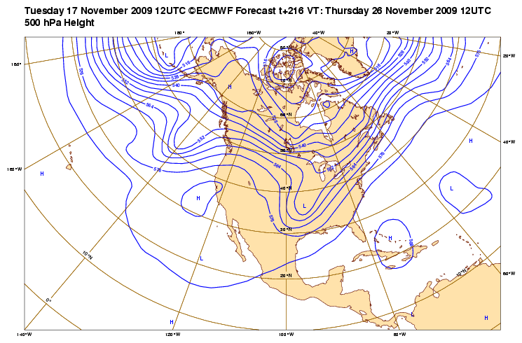
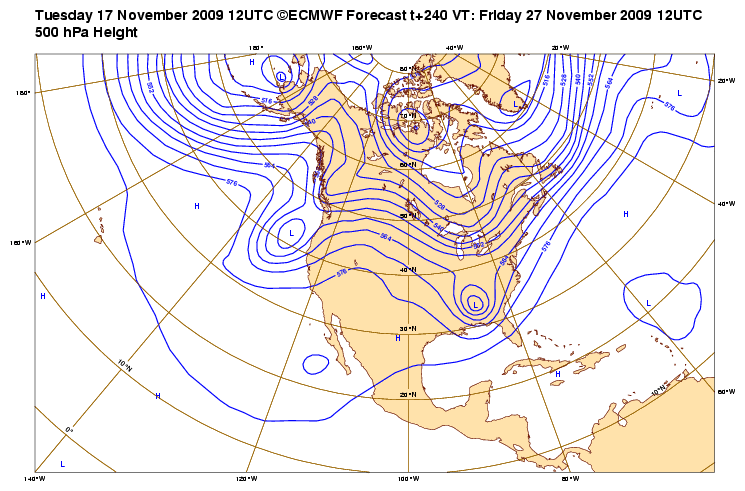
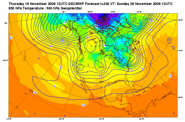
Look what the EC popped out on the 12Z. Can we say cross polar flow? Hmmm...
0 likes
Carla/Alicia/Jerry(In The Eye)/Michelle/Charley/Ivan/Dennis/Katrina/Rita/Wilma/Ike/Harvey
Member: National Weather Association
Wx Infinity Forums
http://wxinfinity.com/index.php
Facebook.com/WeatherInfinity
Twitter @WeatherInfinity
Member: National Weather Association
Wx Infinity Forums
http://wxinfinity.com/index.php
Facebook.com/WeatherInfinity
Twitter @WeatherInfinity
-
HockeyTx82
- S2K Supporter
- Posts: 2810
- Joined: Tue Oct 27, 2009 11:17 am
- Location: Ponder, TX
Re: Texas winter wx thread (2009-2010)
What exactly is cross polar flow and what does that mean for us down here in North Texas? I am still new to this stuff.
0 likes
Don't hold me accountable for anything I post on this forum. Leave the real forecasting up to the professionals.
Location: Ponder, TX (all observation posts are this location unless otherwise noted)
Location: Ponder, TX (all observation posts are this location unless otherwise noted)
-
snow and ice
- Tropical Depression
- Posts: 92
- Joined: Sun Oct 04, 2009 9:56 pm
Re: Texas winter wx thread (2009-2010)
Right on cue. Not on specifics, but in general for the first two weeks of December.
0z GFS:
http://www.nco.ncep.noaa.gov/pmb/nwprod ... _336.shtml
0z GFS:
http://www.nco.ncep.noaa.gov/pmb/nwprod ... _336.shtml
0 likes
Who is online
Users browsing this forum: No registered users and 184 guests