Texas winter wx thread (2009-2010)
Moderator: S2k Moderators
Forum rules
 The posts in this forum are NOT official forecast and should not be used as such. They are just the opinion of the poster and may or may not be backed by sound meteorological data. They are NOT endorsed by any professional institution or STORM2K.

The posts in this forum are NOT official forecast and should not be used as such. They are just the opinion of the poster and may or may not be backed by sound meteorological data. They are NOT endorsed by any professional institution or STORM2K.
-
srainhoutx

- S2K Supporter

- Posts: 6919
- Age: 68
- Joined: Sun Jan 14, 2007 11:34 am
- Location: Haywood County, NC
- Contact:
Re: Texas winter wx thread (2009-2010)
0 likes
Carla/Alicia/Jerry(In The Eye)/Michelle/Charley/Ivan/Dennis/Katrina/Rita/Wilma/Ike/Harvey
Member: National Weather Association
Wx Infinity Forums
http://wxinfinity.com/index.php
Facebook.com/WeatherInfinity
Twitter @WeatherInfinity
Member: National Weather Association
Wx Infinity Forums
http://wxinfinity.com/index.php
Facebook.com/WeatherInfinity
Twitter @WeatherInfinity

Re: Texas winter wx thread (2009-2010)
srainhoutx wrote::uarrow: Agree! Look at Amarillo and Lubbock versus other TX WFO's. Much more experience with wintry weather and also note that the aspect of a bust report does tend to lead to a conservative approach by many forecasters. Also remember some of these same forecasters read what we are saying.
Lol I've always wondered if they did. But it's just weird to me that they haven't even mentioned that it could in fact turn out different than they're saying. That's what makes me think they might have a better handle on it than we think. I hope not, though.
0 likes
-
cctxhurricanewatcher

- Category 5

- Posts: 1206
- Joined: Sun Sep 12, 2004 8:53 pm
- Location: Corpus Christi, Texas
Re: Texas winter wx thread (2009-2010)
Portastorm wrote:joshskeety wrote:All 3 major models GFS/NAM/and ECMWF are now showing significant snowfall west of a Wichita Falls/Eastland/Brownwood line..
All 3 models are also saying that wrap around moisture could impact the area until Thursday morning..
All 3 models are also saying that the DFW area could see 1-3 inches of snow... Dewpoint are in the lower 30's for the DFW area on Wednesday, despite what the NWS is trying to say..
In other words, we are NOT stupid.. If its 1 in the afternoon and your Dewpoint is 31 degrees and the Humidity is 100%, please don't tell me that the model is suggesting a high in the Middle 40's...
Sheesh..
As we have talked about for years here on S2K, some NWSFOs in Texas are better than others when it comes to forecasting winter weather events. Some forecasters are dedicated to the grids and strictly following GFS MOS. Others are not.
I would expect more forecast changes today from NWSFO Fort Worth. They're probably feeling quite challenged by this event and they should be ... upper-low events in Texas during the winter can be very challenging!
If only the old timers from NWS Brownsville were still around.....
0 likes
-
srainhoutx
- S2K Supporter
- Posts: 6919
- Age: 68
- Joined: Sun Jan 14, 2007 11:34 am
- Location: Haywood County, NC
- Contact:
Re: Texas winter wx thread (2009-2010)
Speaking of Brownsville, Updated wording continues the downward trend with temps...
AREA FORECAST DISCUSSION
NATIONAL WEATHER SERVICE BROWNSVILLE TX
936 AM CST MON NOV 30 2009
.DISCUSSION...COLD FRONT HAS CLEARED THE CWA WITH CAA CURRENTLY
INTRUDING DEEP SOUTH TEXAS. HIGH TEMPS OCCURRED BEFORE THE FRONT
MOVED THROUGH WITH TEMPS THE REMAINDER OF THE DAY REMAINING IN THE
50S. WINDS ABOVE THE SURFACE ARE OVER RUNNING THE COOLER AIR BELOW
ALLOWING FOR LIGHT RAIN AND DRIZZLE TO OCCUR AREA WIDE TODAY.
MOTHER NATURE WANTS TO GO BOWLING BY SLOWLY KICKING THE MID LEVEL
LOW THAT IS CURRENTLY CENTERED OVER NORTHWEST OLD MEXICO EASTWARD
TODAY AND TONIGHT. THE EXTRA LIFT ASSOCIATED WITH WEAK
DISTURBANCES AHEAD OF THE LOW SHOULD ALLOW FOR MORE SIGNIFICANT
SHOWERS AND RAINFALL TO OCCUR BY MID TO LATE AFTERNOON AND INTO
TONIGHT. UPDATES TO THE FORECAST THIS MORNING HAVE BEEN REMOVING
THE THUNDERSTORM WORDING AS INSTABILITY IS LIMITED TODAY. CAN/T
RULE OUT ONE OR TWO ROGUE STRIKES THIS AFTERNOON BUT COVERAGE WILL
NOT BE ENOUGH TO WARRANT EVEN SLIGHT CHANCE WORDING. ALSO TWEAKED
TEMPS DOWNWARDS TO ACCOUNT FOR CURRENT TRENDS. UPDATED ZFP WILL BE
SENT SHORTLY WITH COMPLETE UPDATES COMING IN REGULAR AFTERNOON
PACKAGE.
0 likes
Carla/Alicia/Jerry(In The Eye)/Michelle/Charley/Ivan/Dennis/Katrina/Rita/Wilma/Ike/Harvey
Member: National Weather Association
Wx Infinity Forums
http://wxinfinity.com/index.php
Facebook.com/WeatherInfinity
Twitter @WeatherInfinity
Member: National Weather Association
Wx Infinity Forums
http://wxinfinity.com/index.php
Facebook.com/WeatherInfinity
Twitter @WeatherInfinity
-
joshskeety
- Tropical Storm

- Posts: 225
- Joined: Tue Jan 13, 2004 5:58 pm
- Location: Springtown, Texas
Well, there went consistantcy..
12z GFS and 12z ETA swapped places..
Now the ETA is the colder solution and the GFS shows a warmer solution..
Considering we are within 48h, I trust the NAM more than the GFS, especially since the MRF (48-84h) was the colder solution, the the SRF (6h-48h) trends colder..
GFS Still shows 2-5 inches for our area (Abilene), but only 1-2 inches for the DFW area.. While the NAM has 3-6 inches in my area and 2-4 in the DFW area..
BUT..
Something interesting is the GFS is trying to create ANOTHER low in New Mexico at 60h and starts to spread some precip into the Panhandle of Texas... hmmmmm Something to watch I guess...
Josh
0 likes
-
srainhoutx
- S2K Supporter
- Posts: 6919
- Age: 68
- Joined: Sun Jan 14, 2007 11:34 am
- Location: Haywood County, NC
- Contact:
Re:
joshskeety wrote:Well, there went consistantcy..
12z GFS and 12z ETA swapped places..
Now the ETA is the colder solution and the GFS shows a warmer solution..
Considering we are within 48h, I trust the NAM more than the GFS, especially since the MRF (48-84h) was the colder solution, the the SRF (6h-48h) trends colder..
GFS Still shows 2-5 inches for our area (Abilene), but only 1-2 inches for the DFW area.. While the NAM has 3-6 inches in my area and 2-4 in the DFW area..
BUT..
Something interesting is the GFS is trying to create ANOTHER low in New Mexico at 60h and starts to spread some precip into the Panhandle of Texas... hmmmmm Something to watch I guess...
Josh
And another over running event so far on the GFS. This is a very typical El Nino Pattern we are seeing via guidance. Interesting days ahead.
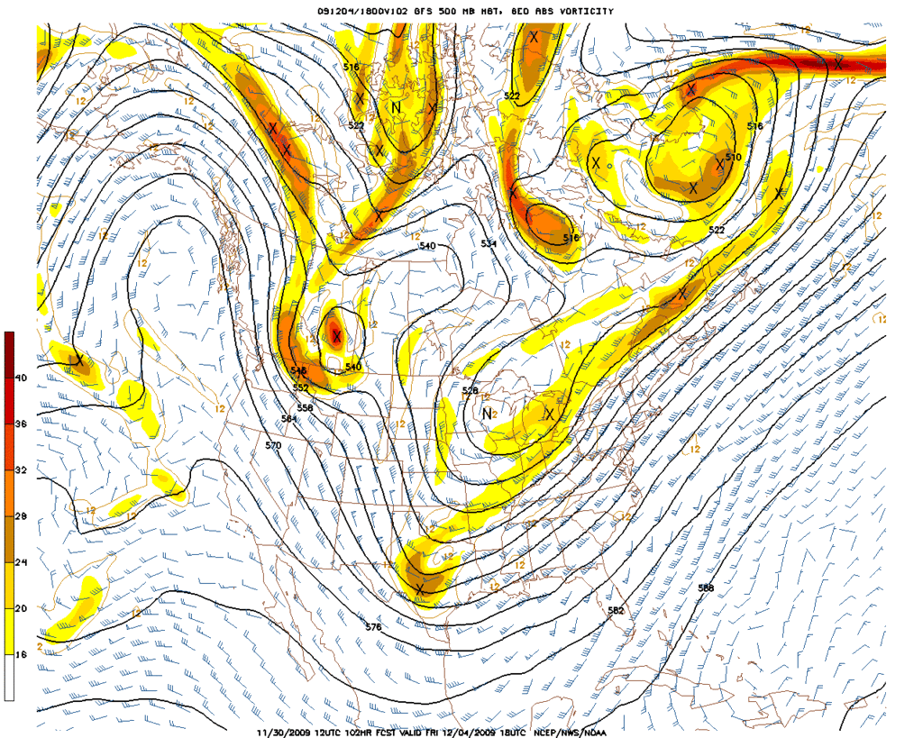
12Z GFS 500mb suggests a lot of energy diving S along the Rockies in the Upper Levels as well as some phasing in the 300mb flow and the Arctic Air making it's push into W Canada/NW PAC at hour 84...
http://www.nco.ncep.noaa.gov/pmb/nwprod ... 0_084l.gif
Last edited by srainhoutx on Mon Nov 30, 2009 11:02 am, edited 1 time in total.
0 likes
Carla/Alicia/Jerry(In The Eye)/Michelle/Charley/Ivan/Dennis/Katrina/Rita/Wilma/Ike/Harvey
Member: National Weather Association
Wx Infinity Forums
http://wxinfinity.com/index.php
Facebook.com/WeatherInfinity
Twitter @WeatherInfinity
Member: National Weather Association
Wx Infinity Forums
http://wxinfinity.com/index.php
Facebook.com/WeatherInfinity
Twitter @WeatherInfinity
-
joshskeety
- Tropical Storm
- Posts: 225
- Joined: Tue Jan 13, 2004 5:58 pm
- Location: Springtown, Texas

-
joshskeety
- Tropical Storm
- Posts: 225
- Joined: Tue Jan 13, 2004 5:58 pm
- Location: Springtown, Texas

-
srainhoutx
- S2K Supporter
- Posts: 6919
- Age: 68
- Joined: Sun Jan 14, 2007 11:34 am
- Location: Haywood County, NC
- Contact:
Re: Texas winter wx thread (2009-2010)
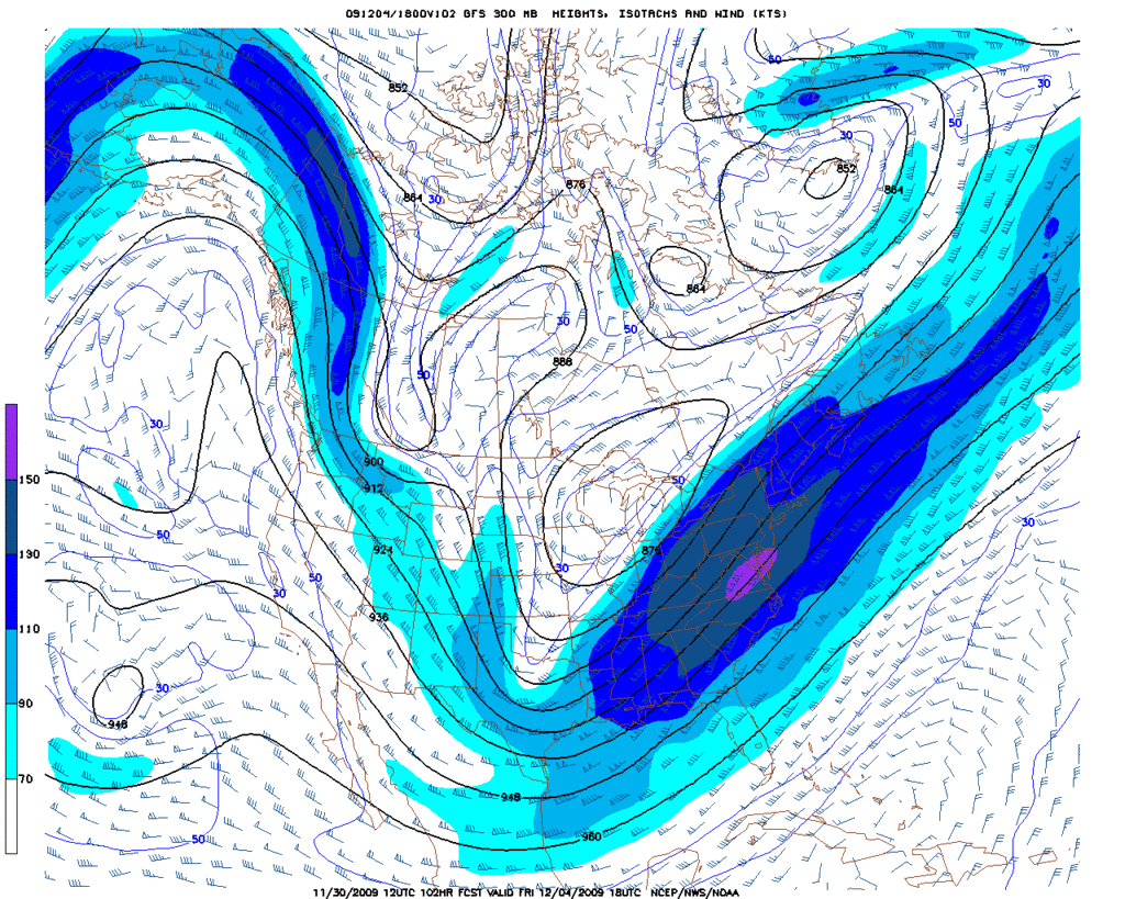
I'll add the 500mb and 300mb maps for hour 102...
0 likes
Carla/Alicia/Jerry(In The Eye)/Michelle/Charley/Ivan/Dennis/Katrina/Rita/Wilma/Ike/Harvey
Member: National Weather Association
Wx Infinity Forums
http://wxinfinity.com/index.php
Facebook.com/WeatherInfinity
Twitter @WeatherInfinity
Member: National Weather Association
Wx Infinity Forums
http://wxinfinity.com/index.php
Facebook.com/WeatherInfinity
Twitter @WeatherInfinity
-
Portastorm

- Storm2k Moderator

- Posts: 9954
- Age: 63
- Joined: Fri Jul 11, 2003 9:16 am
- Location: Round Rock, TX
- Contact:
Re: Texas winter wx thread (2009-2010)
Here is a prime example of what I was talking about earlier ... this is a snippet from the mid-morning forecast discussion out of NWSFO Austin/San Antonio (i.e. New Braunfels):
... HAVE ADJUSTED AFTERNOON TEMPERATURES DOWN BY ABOUT 2-5 DEGREES
AND MAY NOT HAVE GONE COOL ENOUGH GIVEN CURRENT TRENDS. ...
I think it will be important for many in Texas, especially those in west and west central
Texas, to keep up with the very latest forecasts in the next 48 hours. Forecasts could
change rapidly based on the real-time weather.
0 likes
-
srainhoutx
- S2K Supporter
- Posts: 6919
- Age: 68
- Joined: Sun Jan 14, 2007 11:34 am
- Location: Haywood County, NC
- Contact:
Re: Texas winter wx thread (2009-2010)
Portastorm, all TX WFO's are lowering temps that I can see. What will be interesting is how the 12Z GFS is addressed this afternoon from various WFO's. If the ECMWF is onboard or even close, look for some stronger wording from the forecasters.
0 likes
Carla/Alicia/Jerry(In The Eye)/Michelle/Charley/Ivan/Dennis/Katrina/Rita/Wilma/Ike/Harvey
Member: National Weather Association
Wx Infinity Forums
http://wxinfinity.com/index.php
Facebook.com/WeatherInfinity
Twitter @WeatherInfinity
Member: National Weather Association
Wx Infinity Forums
http://wxinfinity.com/index.php
Facebook.com/WeatherInfinity
Twitter @WeatherInfinity
-
HarlequinBoy

- Category 5
- Posts: 1400
- Age: 35
- Joined: Wed Nov 29, 2006 1:57 am
- Location: Memphis
Hmm, the latest models look better for a changeover to snow for Arkansas and the Memphis metro, especially in regards to QPF. Any thoughts on the corridor from Shreveport to Memphis? Offices in Little Rock and Memphis have introduced snow for counties north of the metros. Midtown Memphis has a forecast low of 33 Wednesday night with a 60% chance of rain. It's looking close.
0 likes
-
Portastorm
- Storm2k Moderator
- Posts: 9954
- Age: 63
- Joined: Fri Jul 11, 2003 9:16 am
- Location: Round Rock, TX
- Contact:
Re: Texas winter wx thread (2009-2010)
BTW, if that 12z GFS run were to verify, Austin would see 2 1/2 inches of snow on Friday! 
Somehow, I just don't buy it. Granted, the GFS is trending colder for this week as it should. But how does one explain this new upper-level energy rotating through the larger trough over the southern Plains? I don't recall seeing anything like that in the Euro or in previous GFS runs.
Somehow, I just don't buy it. Granted, the GFS is trending colder for this week as it should. But how does one explain this new upper-level energy rotating through the larger trough over the southern Plains? I don't recall seeing anything like that in the Euro or in previous GFS runs.
0 likes
-
srainhoutx
- S2K Supporter
- Posts: 6919
- Age: 68
- Joined: Sun Jan 14, 2007 11:34 am
- Location: Haywood County, NC
- Contact:
Re: Texas winter wx thread (2009-2010)
I'm trying to get wxman57 to post here. Here is his thoughts concerning the 12Z GFS in the "local Forum"...
Yes, today's 12Z GFS does forecast frozen precip for Houston this Friday afternoon/evening. Question is, is it right about both the vertical temperature profile AND the wave of energy rotating across Texas on Friday? That remains to be seen. Certainly, something of interest to follow this week.
0 likes
Carla/Alicia/Jerry(In The Eye)/Michelle/Charley/Ivan/Dennis/Katrina/Rita/Wilma/Ike/Harvey
Member: National Weather Association
Wx Infinity Forums
http://wxinfinity.com/index.php
Facebook.com/WeatherInfinity
Twitter @WeatherInfinity
Member: National Weather Association
Wx Infinity Forums
http://wxinfinity.com/index.php
Facebook.com/WeatherInfinity
Twitter @WeatherInfinity
-
wxman22

- Category 5
- Posts: 1893
- Joined: Mon Jan 30, 2006 12:39 am
- Location: Wichita Falls, TX
- Contact:
Re: Texas winter wx thread (2009-2010)
Even though i may be setting my hopes up for dissapointment its hard not to get a little excited when somthin like that shows up thats only 102hrs away and its the 12z run.For what its worth last week the GFS was the first model to show the cold core low. And then the other models started to latch on... Lets see what the 18z and more importantly what the 0z shows later tonight...
0 likes
-
serenata09
- Tropical Storm
- Posts: 166
- Joined: Fri Jan 18, 2008 7:55 pm
- Location: Dallas, TX
Re: Texas winter wx thread (2009-2010)
What is the weather looking like for DFW over the next couple of days? Chances for snow?
0 likes

Re: Texas winter wx thread (2009-2010)
Portastorm wrote:BTW, if that 12z GFS run were to verify, Austin would see 2 1/2 inches of snow on Friday!
Somehow, I just don't buy it. Granted, the GFS is trending colder for this week as it should. But how does one explain this new upper-level energy rotating through the larger trough over the southern Plains? I don't recall seeing anything like that in the Euro or in previous GFS runs.
I agree Porta, that is a 180 from previous runs just a few days ago. What I find a little encouraging is that it's only 4-5 days out instead of the infamous 10-12. I will be looking forward to the 18z model.
0 likes
-
joshskeety
- Tropical Storm
- Posts: 225
- Joined: Tue Jan 13, 2004 5:58 pm
- Location: Springtown, Texas
Re: Texas winter wx thread (2009-2010)
serenata09 wrote:What is the weather looking like for DFW over the next couple of days? Chances for snow?
Mild today, turning colder tonight into tomorrow.. Overnight Tuesday into Wednesday there could be some snow and into the day Wednesday, but the big question for the DFW area is surface temps.. Either way, there is some good precip whether it be rain or snow..
0 likes
-
CaptinCrunch

- S2K Supporter
- Posts: 8776
- Age: 58
- Joined: Mon Nov 03, 2003 4:33 pm
- Location: Kennedale, TX (Tarrant Co.)
Re: Texas winter wx thread (2009-2010)
joshskeety wrote:serenata09 wrote:What is the weather looking like for DFW over the next couple of days? Chances for snow?
Mild today, turning colder tonight into tomorrow.. Overnight Tuesday into Wednesday there could be some snow and into the day Wednesday, but the big question for the DFW area is surface temps.. Either way, there is some good precip whether it be rain or snow..
dont' see snow just yet, very cold rain yes, but dew points wont allow for a snow event, maybe a few wet flakes mixed in but nothing to write home about. It wont be till precip moves out and the dry cold air mass settles in till we see below freezing temps, and it will only be 32 at best.
0 likes
-
joshskeety
- Tropical Storm
- Posts: 225
- Joined: Tue Jan 13, 2004 5:58 pm
- Location: Springtown, Texas
Re: Texas winter wx thread (2009-2010)
CaptinCrunch wrote:joshskeety wrote:serenata09 wrote:What is the weather looking like for DFW over the next couple of days? Chances for snow?
Mild today, turning colder tonight into tomorrow.. Overnight Tuesday into Wednesday there could be some snow and into the day Wednesday, but the big question for the DFW area is surface temps.. Either way, there is some good precip whether it be rain or snow..
dont' see snow just yet, very cold rain yes, but dew points wont allow for a snow event, maybe a few wet flakes mixed in but nothing to write home about. It wont be till precip moves out and the dry cold air mass settles in till we see below freezing temps, and it will only be 32 at best.
I dont think so man.. Dewpoints at 850mb look good enough to support snow in the DFW area Wednesday morning according to the 12z ECMWF.. DFW is at -2 (28-30 F) dewpoints..
http://vortex.plymouth.edu/cgi-bin/gen_ ... &cu=latest
0 likes
Who is online
Users browsing this forum: No registered users and 431 guests