

TROPICAL CYCLONE TECHNICAL BULLETIN: AUSTRALIA - WESTERN REGION
Issued by PERTH TROPICAL CYCLONE WARNING CENTRE
at: 1306 UTC 17/12/2009
Name: Tropical Cyclone Laurence
Identifier: 01U
Data At: 1200 UTC
Latitude: 17.4S
Longitude: 124.5E
Location Accuracy: within 20 nm [35 km]
Movement Towards: south [175 deg]
Speed of Movement: 3 knots [6 km/h]
Maximum 10-Minute Wind: 35 knots [65 km/h]
Maximum 3-Second Wind Gust: 50 knots [95 km/h]
Central Pressure: 993 hPa
Radius of 34-knot winds NE quadrant: 30 nm [55 km]
Radius of 34-knot winds SE quadrant: 30 nm [55 km]
Radius of 34-knot winds SW quadrant: 30 nm [55 km]
Radius of 34-knot winds NW quadrant: 30 nm [55 km]
Radius of 48-knot winds NE quadrant:
Radius of 48-knot winds SE quadrant:
Radius of 48-knot winds SW quadrant:
Radius of 48-knot winds NW quadrant:
Radius of 64-knot winds:
Radius of Maximum Winds: 10 nm [20 km]
Dvorak Intensity Code: T3.0/3.5/W1.5/24HRS
Pressure of outermost isobar: 1002 hPa
Radius of outermost closed isobar: 60 nm [110 km]
Storm Depth: Deep
FORECAST DATA
Date/Time : Location : Loc. Accuracy: Max Wind : Central Pressure
[UTC] : degrees : nm [km]: knots[km/h]: hPa
+12: 18/0000: 17.8S 124.2E: 040 [075]: 030 [055]: 995
+24: 18/1200: 18.1S 123.7E: 060 [110]: 030 [055]: 996
+36: 19/0000: 18.1S 122.6E: 080 [150]: 030 [055]: 997
+48: 19/1200: 18.1S 121.8E: 100 [185]: 040 [075]: 992
+60: 20/0000: 18.3S 121.2E: 130 [240]: 050 [095]: 985
+72: 20/1200: 18.4S 120.6E: 160 [295]: 065 [120]: 970
REMARKS:
Tropical Cyclone Laurence crossed the Kimberley coast northeast of Derby as a
small but intense system and has since weakened over land. Dvorak: shear pattern
gives DT of 3.5, PAT = 3.0 and CI held at 3.5. Mean surface winds estimated at
35 knots due to the system being over land.
Although weakening, heavy rainfall continues with 24 hour rainfall totals of
about 300mm being reported along the cyclone track.
Laurence is expected to weaken further and be slow moving in the short term as
it tracks over land on a general south to southwest track. In the longer term a
westerly track seems likely as a mid-level ridge develops to the south. The
system should move off the west Kimberley coast in 36 to 48 hours time and
redevelop into a tropical cyclone over warm ocean waters and a favourable upper
level wind pattern.
Copyright Commonwealth of Australia
==
The next bulletin for this system will be issued by: 17/1900 UTC by Perth TCWC.
TIMOR SEA : TROPICAL CYCLONE LAURENCE (06S)
Moderator: S2k Moderators
-
HURAKAN

- Professional-Met

- Posts: 46084
- Age: 39
- Joined: Thu May 20, 2004 4:34 pm
- Location: Key West, FL
- Contact:
TROPICAL CYCLONE ADVICE NUMBER 51
Issued at 8:55 pm WST on Thursday, 17 December 2009
BY THE BUREAU OF METEOROLOGY
TROPICAL CYCLONE WARNING CENTRE PERTH
A Cyclone WARNING is current for areas in the Derby region of the west
Kimberley.
A Cyclone WATCH is current for coastal areas from Cape Leveque to Wallal,
including Broome.
At 8:00 pm WST Tropical Cyclone Laurence, Category 1 was estimated to be
95 kilometres east of Derby and
moving south at 6 kilometres per hour.
Tropical Cyclone Laurence has continued to weaken as it moves slowly over land
east of Derby. GALES with gusts to 95 kilometres per hour are possible close to
the cyclone centre. GALES are possible near the centre overnight as Laurence
moves to the south or southwest.
HEAVY RAIN is expected to continue over the northwest Kimberley. Daily rainfall
totals in excess of 100mm are expected with isolated falls as high as 300mm
possible near the path of the cyclone.
Laurence is expected to weaken below cyclone intensity on Friday and take a more
westerly track towards the west Kimberley coast. It is expected to then
reintensify as it moves over open water during the weekend. GALES could develop
along the west Kimberley coast between Cape Leveque and Wallal, including Broome
later on Saturday or Sunday.
FESA-State Emergency Service advises of the following community alerts:
ALL CLEAR WITH CAUTION: People in or near Derby, Cape Leveque, One Arm Point,
Djarindjin, Lombadina and surrounding smaller communities, Koolan Island and
Cockatoo Island are advised that the wind danger has passed but you need to take
care to avoid the dangers caused by any damage.
Details of Tropical Cyclone Laurence at 8:00 pm WST:
.Centre located near...... 17.4 degrees South 124.5 degrees East
.Location accuracy........ within 35 kilometres
.Recent movement.......... towards the south at 6 kilometres per hour
.Wind gusts near centre... 95 kilometres per hour and weakening
.Severity category........ 1
.Central pressure......... 993 hectoPascals
The next advice will be issued by 12:00 am WST Friday 18 December.Cyclone
advices and State Emergency Service Community Alerts are available by
dialling 1300 659 210
A map showing the track of the cyclone is available at:
http://www.bom.gov.au/weather/cyclone
0 likes
-
HURAKAN
- Professional-Met
- Posts: 46084
- Age: 39
- Joined: Thu May 20, 2004 4:34 pm
- Location: Key West, FL
- Contact:
TROPICAL CYCLONE ADVICE NUMBER 52
Issued at 11:50 pm WST on Thursday, 17 December 2009
BY THE BUREAU OF METEOROLOGY
TROPICAL CYCLONE WARNING CENTRE PERTH
A Cyclone WARNING is current for areas in the Derby region of the west
Kimberley.
A Cyclone WATCH is current for coastal areas from Cape Leveque to Wallal,
including Broome.
At 11:00 pm WST Tropical Cyclone Laurence, Category 1 was estimated to be
95 kilometres east of Derby and
was near stationary.
Tropical Cyclone Laurence has continued to weaken as it moves slowly over land
east of Derby. GALES with gusts to 95 kilometres per hour are possible close to
the cyclone centre. GALES are possible near the centre overnight as Laurence
moves to the south or southwest.
HEAVY RAIN is expected to continue over the northwest Kimberley. Daily rainfall
totals in excess of 100mm are expected with isolated falls as high as 300mm
possible near the path of the cyclone.
Laurence is expected to weaken below cyclone intensity on Friday and take a more
westerly track towards the west Kimberley coast. It is expected to then
reintensify as it moves over open water during the weekend. GALES could develop
along the west Kimberley coast between Cape Leveque and Wallal, including Broome
later on Saturday or Sunday.
FESA-State Emergency Service advises of the following community alerts:
ALL CLEAR WITH CAUTION: People in or near Derby, Cape Leveque, One Arm Point,
Djarindjin, Lombadina and surrounding smaller communities, Koolan Island and
Cockatoo Island are advised that the wind danger has passed but you need to take
care to avoid the dangers caused by any damage.
Details of Tropical Cyclone Laurence at 11:00 pm WST:
.Centre located near...... 17.4 degrees South 124.5 degrees East
.Location accuracy........ within 35 kilometres
.Recent movement.......... near stationary
.Wind gusts near centre... 95 kilometres per hour
.Severity category........ 1
.Central pressure......... 993 hectoPascals
The next advice will be issued by 3:00 am WST Friday 18 December.
Cyclone advices and State Emergency Service Community Alerts are available by
dialling 1300 659 210
A map showing the track of the cyclone is available at:
http://www.bom.gov.au/weather/cyclone
0 likes
-
HURAKAN
- Professional-Met
- Posts: 46084
- Age: 39
- Joined: Thu May 20, 2004 4:34 pm
- Location: Key West, FL
- Contact:
TROPICAL CYCLONE ADVICE NUMBER 53
Issued at 2:50 am WST on Friday, 18 December 2009
BY THE BUREAU OF METEOROLOGY
TROPICAL CYCLONE WARNING CENTRE PERTH
A Cyclone WARNING is current for areas in the Derby region of the west
Kimberley.
A Cyclone WATCH is current for coastal areas from Cape Leveque to Wallal,
including Broome.
At 2:00 am WST Tropical Cyclone Laurence, Category 1 was estimated to be
95 kilometres east southeast of Derby and
moving south at 4 kilometres per hour.
Tropical Cyclone Laurence has continued to weaken as it moves slowly over land
east of Derby. GALES with damaging gusts to 95 kilometres per hour are possible
close to the cyclone centre. GALES are possible near the centre early this
morning as Laurence moves to the south or southwest.
HEAVY RAIN is expected to continue over the northwest Kimberley. Daily rainfall
totals in excess of 100mm are expected with isolated falls as high as 300mm
possible near the path of the cyclone.
Laurence is expected to weaken below cyclone intensity during this morning and
take a more westerly track towards the west Kimberley coast. It is expected to
then reintensify as it moves over open water during the weekend. GALES could
develop along the west Kimberley coast between Cape Leveque and Wallal,
including Broome later on Saturday or Sunday.
FESA-State Emergency Service advises of the following community alerts:
ALL CLEAR WITH CAUTION: People in or near Derby, Cape Leveque, One Arm Point,
Djarindjin, Lombadina and surrounding smaller communities, Koolan Island and
Cockatoo Island are advised that the wind danger has passed but you need to take
care to avoid the dangers caused by any damage.
Details of Tropical Cyclone Laurence at 2:00 am WST:
.Centre located near...... 17.5 degrees South 124.5 degrees East
.Location accuracy........ within 55 kilometres
.Recent movement.......... towards the south at 4 kilometres per hour
.Wind gusts near centre... 95 kilometres per hour and weakening
.Severity category........ 1
.Central pressure......... 993 hectoPascals
The next advice will be issued by 6:00 am WST Friday 18 December.Cyclone advices
and State Emergency Service Community Alerts are available by
dialling 1300 659 210
A map showing the track of the cyclone is available at:
http://www.bom.gov.au/weather/cyclone
0 likes

-
HURAKAN
- Professional-Met
- Posts: 46084
- Age: 39
- Joined: Thu May 20, 2004 4:34 pm
- Location: Key West, FL
- Contact:
Re: TIMOR SEA : TROPICAL CYCLONE LAURENCE (06S)
TROPICAL CYCLONE ADVICE NUMBER 54
Issued at 5:00 am WST on Friday, 18 December 2009
BY THE BUREAU OF METEOROLOGY
TROPICAL CYCLONE WARNING CENTRE PERTH
A Cyclone WARNING is current for areas in the Derby region of the west
Kimberley.
A Cyclone WATCH is current for coastal areas from Cape Leveque to Wallal,
including Broome.
At 5:00 am WST Tropical Cyclone Laurence, Category 1 was estimated to be
100 kilometres east southeast of Derby and
moving south at 4 kilometres per hour.
Tropical Cyclone Laurence has continued to weaken as it moves slowly over land
east of Derby. GALES with damaging gusts to 95 kilometres per hour are possible
close to the cyclone centre. GALES are possible near the centre early this
morning as Laurence moves to the south or southwest.
HEAVY RAIN is expected to continue over the northwest Kimberley. Daily rainfall
totals in excess of 100mm are expected with isolated falls as high as 300mm
possible near the path of the cyclone.
Laurence is expected to weaken below cyclone intensity during this morning and
take a more westerly track towards the west Kimberley coast. It is expected to
then reintensify as it moves over open water during the weekend. GALES could
develop along the west Kimberley coast between Cape Leveque and Wallal,
including Broome later on Saturday or Sunday.
FESA-State Emergency Service advises of the following community alerts:
ALL CLEAR WITH CAUTION: People in or near Derby, Cape Leveque, One Arm Point,
Djarindjin, Lombadina and surrounding smaller communities, Koolan Island and
Cockatoo Island are advised that the wind danger has passed but you need to take
care to avoid the dangers caused by any damage.
Details of Tropical Cyclone Laurence at 5:00 am WST:
.Centre located near...... 17.6 degrees South 124.5 degrees East
.Location accuracy........ within 55 kilometres
.Recent movement.......... towards the south at 4 kilometres per hour
.Wind gusts near centre... 95 kilometres per hour and weakening
.Severity category........ 1
.Central pressure......... 993 hectoPascals
The next advice will be issued by 9:00 am WST Friday 18 December.Cyclone advices
and State Emergency Service Community Alerts are available by
dialling 1300 659 210
A map showing the track of the cyclone is available at:
http://www.bom.gov.au/weather/cyclone
0 likes


-
HURAKAN
- Professional-Met
- Posts: 46084
- Age: 39
- Joined: Thu May 20, 2004 4:34 pm
- Location: Key West, FL
- Contact:
Re:
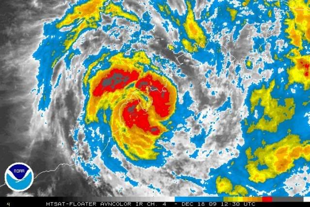
CrazyC83 wrote:Center reforming over water?
Loop : http://www.ssd.noaa.gov/mtsat/flt/t2/flash-rgb.html
Still looks inland
0 likes
-
HURAKAN
- Professional-Met
- Posts: 46084
- Age: 39
- Joined: Thu May 20, 2004 4:34 pm
- Location: Key West, FL
- Contact:
TROPICAL CYCLONE ADVICE NUMBER 56
Issued at 11:50 am WST on Friday, 18 December 2009
BY THE BUREAU OF METEOROLOGY
TROPICAL CYCLONE WARNING CENTRE PERTH
The Cyclone WARNING for inland parts of the west Kimberley has been cancelled.
A Cyclone WATCH continues for coastal areas from Cape Leveque to Wallal,
including Broome.
At 11:00 am WST Ex-Tropical Cyclone Laurence was relocated by satellite and
surface observations and estimated to be
85 kilometres east of Derby and nearly stationary.
Ex-Tropical Cyclone Laurence has weakened below tropical cyclone intensity.
Winds have eased below gale force but gusty squalls are still possible. The low
is almost stationary over the west Kimberley but is expected to begin to move
westwards towards Derby during this afternoon and evening. A period of squally
weather is expected overnight in Derby as the low moves towards the west
Kimberley coast.
The low is expected to move off the west Kimberley coast late on Saturday or on
Sunday. It is then likely to reintensify and GALES could develop along the west
Kimberley coast between Cape Leveque and Wallal, including Broome, late on
Saturday or on Sunday.
Record daily rainfall totals have been recorded at Kimberley Downs and Napier
Downs in the west Kimberley, but the heaviest falls have fallen outside the
Fitzroy River catchment. HEAVY RAIN is expected to continue over parts of the
northwest Kimberley today.
FESA-State Emergency Service advises that there are no community alerts at
present.
Communities in the western Kimberley and northern Pilbara should listen for the
next advice.
Details of Ex-Tropical Cyclone Laurence at 11:00 am WST:
.Centre located near...... 17.2 degrees South 124.4 degrees East
.Location accuracy........ within 45 kilometres
.Recent movement.......... near stationary
.Wind gusts near centre... 85 kilometres per hour and weakening
.Severity category........ below cyclone intensity
.Central pressure......... 992 hectoPascals
The next advice will be issued by 3:00 pm WST Friday 18 December.Cyclone advices
and State Emergency Service Community Alerts are available by
dialling 1300 659 210
A map showing the track of the cyclone is available at:
http://www.bom.gov.au/weather/cyclone
0 likes

-
HURAKAN
- Professional-Met
- Posts: 46084
- Age: 39
- Joined: Thu May 20, 2004 4:34 pm
- Location: Key West, FL
- Contact:
Re: TIMOR SEA : EX-TROPICAL CYCLONE LAURENCE (06S)
TROPICAL CYCLONE ADVICE NUMBER 58
Issued at 5:45 pm WST on Friday, 18 December 2009
BY THE BUREAU OF METEOROLOGY
TROPICAL CYCLONE WARNING CENTRE PERTH
A Cyclone WARNING is current for coastal areas from Cape Leveque to Bidyadanga,
including Broome.
A Cyclone WATCH continues for coastal areas from Bidyadanga to Wallal.
At 5:00 pm WST Ex-Tropical Cyclone Laurence was estimated to be
20 kilometres east northeast of Derby and moving
west at 7 kilometres per hour.
Ex-Tropical Cyclone Laurence has begun to move westwards towards the west
Kimberley coast. A period of squally weather is expected in Derby as the low
moves close by.
The low is expected to move off the west Kimberley coast during Saturday. It is
then likely to reintensify and GALES could develop along the west Kimberley
coast between Cape Leveque and Bidyadanga, including Broome, on Saturday evening
or on Sunday. As the system moves westwards GALES could extend further down the
coast to Wallal late on Sunday.
Record daily rainfall totals have been recorded at Kimberley Downs and Napier
Downs in the west Kimberley, but the heaviest falls have fallen outside the
Fitzroy River catchment. HEAVY RAIN is expected to continue over parts of the
northwest Kimberley this evening.
FESA-State Emergency Service advises that there are no community alerts at
present.
Communities in the western Kimberley and northern Pilbara should listen for the
next advice.
Details of Ex-Tropical Cyclone Laurence at 5:00 pm WST:
.Centre located near...... 17.2 degrees South 123.8 degrees East
.Location accuracy........ within 35 kilometres
.Recent movement.......... towards the west at 7 kilometres per hour
.Wind gusts near centre... 85 kilometres per hour
.Severity category........ below cyclone intensity
.Central pressure......... 998 hectoPascals
The next advice will be issued by 9:00 pm WST Friday 18 December.
Cyclone advices and State Emergency Service Community Alerts are available by
dialling 1300 659 210
A map showing the track of the cyclone is available at:
http://www.bom.gov.au/weather/cyclon
0 likes
-
HURAKAN
- Professional-Met
- Posts: 46084
- Age: 39
- Joined: Thu May 20, 2004 4:34 pm
- Location: Key West, FL
- Contact:
TROPICAL CYCLONE ADVICE NUMBER 59
Issued at 8:55 pm WST on Friday, 18 December 2009
BY THE BUREAU OF METEOROLOGY
TROPICAL CYCLONE WARNING CENTRE PERTH
A Cyclone WARNING continues for coastal areas from Cape Leveque to Bidyadanga,
including Broome.
A Cyclone WATCH continues for coastal areas from Bidyadanga to Wallal.
At 8:00 pm WST Ex-Tropical Cyclone Laurence was estimated to be
20 kilometres north of Derby and moving
west northwest at 7 kilometres per hour.
Ex-Tropical Cyclone Laurence has begun to move westwards towards the west
Kimberley coast. A period of squally weather is expected in Derby as the low
moves close by this evening.
The low is expected to move off the west Kimberley coast during Saturday. It is
then likely to reintensify and GALES could develop along the west Kimberley
coast between Cape Leveque and Bidyadanga, including Broome, on Saturday evening
or on Sunday. As the system moves westwards GALES could extend further down the
coast to Wallal late on Sunday.
Record daily rainfall totals have been recorded at Kimberley Downs and Napier
Downs in the west Kimberley, but the heaviest falls have fallen outside the
Fitzroy River catchment. HEAVY RAIN is expected to continue over parts of the
northwest Kimberley overnight.
FESA-State Emergency Service advises that there are no community alerts at
present.
Communities in the western Kimberley and northern Pilbara should listen for the
next advice.
Details of Ex-Tropical Cyclone Laurence at 8:00 pm WST:
.Centre located near...... 17.1 degrees South 123.6 degrees East
.Location accuracy........ within 35 kilometres
.Recent movement.......... towards the west northwest at 7 kilometres per hour
.Wind gusts near centre... 85 kilometres per hour
.Severity category........ below cyclone intensity
.Central pressure......... 998 hectoPascals
The next advice will be issued by 12:00 am WST Saturday 19 December.
Cyclone advices and State Emergency Service Community Alerts are available by
dialling 1300 659 210
A map showing the track of the cyclone is available at:
http://www.bom.gov.au/weather/cyclone
0 likes
-
HURAKAN
- Professional-Met
- Posts: 46084
- Age: 39
- Joined: Thu May 20, 2004 4:34 pm
- Location: Key West, FL
- Contact:
TROPICAL CYCLONE TECHNICAL BULLETIN: AUSTRALIA - WESTERN REGION
Issued by PERTH TROPICAL CYCLONE WARNING CENTRE
at: 1259 UTC 18/12/2009
Name: Ex-Tropical Cyclone Laurence
Identifier: 01U
Data At: 1200 UTC
Latitude: 17.1S
Longitude: 123.6E
Location Accuracy: within 20 nm [35 km]
Movement Towards: west northwest [298 deg]
Speed of Movement: 4 knots [8 km/h]
Maximum 10-Minute Wind: 30 knots [55 km/h]
Maximum 3-Second Wind Gust: 45 knots [85 km/h]
Central Pressure: 998 hPa
Radius of 34-knot winds NE quadrant:
Radius of 34-knot winds SE quadrant:
Radius of 34-knot winds SW quadrant:
Radius of 34-knot winds NW quadrant:
Radius of 48-knot winds NE quadrant:
Radius of 48-knot winds SE quadrant:
Radius of 48-knot winds SW quadrant:
Radius of 48-knot winds NW quadrant:
Radius of 64-knot winds:
Radius of Maximum Winds: N/A nm N/A km
Dvorak Intensity Code: N/A
Pressure of outermost isobar: 1004 hPa
Radius of outermost closed isobar: 60 nm [110 km]
Storm Depth: Deep
FORECAST DATA
Date/Time : Location : Loc. Accuracy: Max Wind : Central Pressure
[UTC] : degrees : nm [km]: knots[km/h]: hPa
+12: 19/0000: 16.9S 122.8E: 040 [075]: 030 [055]: 998
+24: 19/1200: 17.2S 122.0E: 060 [110]: 040 [075]: 993
+36: 20/0000: 17.5S 120.9E: 080 [150]: 050 [095]: 987
+48: 20/1200: 18.0S 120.1E: 100 [185]: 055 [100]: 981
+60: 21/0000: 18.4S 119.5E: 140 [260]: 065 [120]: 973
+72: 21/1200: 18.9S 119.5E: 180 [335]: 080 [150]: 959
REMARKS:
Ex-TC Laurence has begun to track steadily westwards toward the coast. This
motion is likely to continue under the influence of low level flow until the
system moves off the west Kimberley coast. As it moves off the coast vertical
wind shear is expected to be light and with a well developed low to mid level
circulation and a moist profile through depth the system is expected to
redevelop once over open water. The system is likely to move offshore during
Saturday. Once it redevelops it will experience a weak deep layer steering
pattern and motion will slow.
Rainfall totals near the centre have been over 200mm in the last 24 hours, with
isolated heavier falls. Most rain fell in the Leonard River catchment rather
than the Fitzroy River catchment.
Copyright Commonwealth of Australia
==
The next bulletin for this system will be issued by: 18/1900 UTC by Perth TCWC.
0 likes
Re: TIMOR SEA : EX-TROPICAL CYCLONE LAURENCE (06S)
Cool system. Hanging together in that tropical moisture. Good rain for that dry part of Australia.
0 likes
-
HURAKAN
- Professional-Met
- Posts: 46084
- Age: 39
- Joined: Thu May 20, 2004 4:34 pm
- Location: Key West, FL
- Contact:
TROPICAL CYCLONE ADVICE NUMBER 60
Issued at 11:45 pm WST on Friday, 18 December 2009
BY THE BUREAU OF METEOROLOGY
TROPICAL CYCLONE WARNING CENTRE PERTH
A Cyclone WARNING continues for coastal areas from Cape Leveque to Bidyadanga,
including Broome.
A Cyclone WATCH continues for coastal areas from Bidyadanga to Wallal.
At 11:00 pm WST Ex-Tropical Cyclone Laurence was estimated to be
65 kilometres west northwest of Derby and moving
west northwest at 11 kilometres per hour.
Ex-Tropical Cyclone Laurence is moving westwards over the Dampier Peninsula
towards the west Kimberley coast.
The low is expected to move off the west Kimberley coast during Saturday. It is
then likely to reintensify and GALES could develop along the west Kimberley
coast between Cape Leveque and Bidyadanga, including Broome, during Saturday. As
the system moves westwards GALES could extend further down the coast to Wallal
late on Sunday.
Heavy rainfall is expected to continue in the west Kimberley with 24 hour falls
in excess of 200mm possible.
FESA-State Emergency Service advises that there are no community alerts at
present.
Communities in the western Kimberley and northern Pilbara should listen for the
next advice.
Details of Ex-Tropical Cyclone Laurence at 11:00 pm WST:
.Centre located near...... 17.0 degrees South 123.1 degrees East
.Location accuracy........ within 35 kilometres
.Recent movement.......... towards the west northwest at 11 kilometres per hour
.Wind gusts near centre... 85 kilometres per hour
.Severity category........ below cyclone intensity
.Central pressure......... 998 hectoPascals
The next advice will be issued by 3:00 am WST Saturday 19 December.
Cyclone advices and State Emergency Service Community Alerts are available by
dialling 1300 659 210
A map showing the track of the cyclone is available at:
http://www.bom.gov.au/weather/cyclone
0 likes
Who is online
Users browsing this forum: No registered users and 71 guests