The posts in this forum are NOT official forecast and should not be used as such. They are just the opinion of the poster and may or may not be backed by sound meteorological data. They are NOT endorsed by any professional institution or


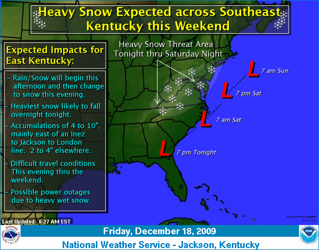
...SIGNIFICANT WINTER STORM EXPECTED TO AFFECT THE REGION TODAY
THROUGH SATURDAY NIGHT...
LOW PRESSURE WILL MOVE FROM THE GULF OF MEXICO TO THE OUTER
BANKS OF NORTH CAROLINA BY SATURDAY MORNING. THIS LOW WILL SLOW
DOWN SATURDAY MORNING...THEN SLIDE NORTH OFF THE MID ATLANTIC
COAST BY SATURDAY NIGHT. MEANWHILE...HIGH PRESSURE RIDGES DOWN
FROM SOUTHEAST CANADA PROVIDING COLD AIR. THIS SETUP BRINGS A
MAJOR SNOWSTORM TO THE AREA.
NCZ001>003-018>020-VAZ009-012-015-016-181900-
/O.CON.KRNK.WS.W.0008.091218T1400Z-091220T0000Z/
ASHE-ALLEGHANY NC-SURRY-WATAUGA-WILKES-YADKIN-SMYTH-WYTHE-GRAYSON-
CARROLL-
INCLUDING THE CITIES OF...WEST JEFFERSON...SPARTA...BOONE...
WILKESBORO...YADKINVILLE...MARION...WYTHEVILLE...INDEPENDENCE...
WHITETOP...TROUTDALE...VOLNEY
550 AM EST FRI DEC 18 2009
...WINTER STORM WARNING REMAINS IN EFFECT FROM 9 AM THIS MORNING
TO 7 PM EST SATURDAY...
A WINTER STORM WARNING REMAINS IN EFFECT FROM 9 AM THIS MORNING
TO 7 PM EST SATURDAY.
* A WINTRY MIX OF SLEET...SNOW AND FREEZING RAIN WILL MOVE IN LATE
THIS MORNING...CHANGING TO ALL SNOW BY LATE THIS AFTERNOON. SNOW
WILL BECOME HEAVIER LATE IN THE DAY AND THIS
EVENING...ESPECIALLY ALONG THE BLUE RIDGE. THE SNOW CONTINUES
INTO SATURDAY BEFORE TAPERING OFF SATURDAY AFTERNOON.
* TRAVEL WILL BECOME DIFFICULT IN THE WARNED AREA. VISIBILITIES
WILL BE REDUCED. DOWNED TREES OR TREE LIMBS ALONG WITH POWER
OUTAGES MAY OCCUR.
* STORM TOTAL SNOW AMOUNTS OF 12 TO 18 INCHES ARE EXPECTED...WITH
HIGHER AMOUNTS ACROSS THE BLUE RIDGE.