Mid Atlantic Winter Storms 2009-2010 updated
Moderator: S2k Moderators
Forum rules
The posts in this forum are NOT official forecast and should not be used as such. They are just the opinion of the poster and may or may not be backed by sound meteorological data. They are NOT endorsed by any professional institution or STORM2K.
- brunota2003
- S2K Supporter
- Posts: 9476
- Age: 33
- Joined: Sat Jul 30, 2005 9:56 pm
- Location: Stanton, KY...formerly Havelock, NC
- Contact:
Ouch...looking at the latest radar trends, things seem to be winding down early in NC. Looks like a major dry slot is being punched into the precip. Eastern NC is pretty much dry, western NC is pretty much dry, and central NC's precip looks like it is winding down. It also appears this will be moving into Va and winding things down there as well. This may end up knocking snow totals down a bit, if it happens.
What are everyone else's thoughts?
Radar image for the Northeast:
What are everyone else's thoughts?
Radar image for the Northeast:
0 likes
-
- Category 5
- Posts: 2165
- Joined: Fri Oct 19, 2007 4:00 pm
- Location: Fairfax, VA
- WeatherLovingDoc
- S2K Supporter
- Posts: 453
- Joined: Fri Sep 05, 2008 10:08 pm
- Location: Washington D.C.
Re: Mid Atlantic Winter Storm 12/18-12/19
Yep, hubbie just measured 8 inches here in NoVa. But wind is gusting strong and it's still coming down at a good pace. Family all got home safely last night btw. Daughter said it scared her some to be driving (with male friends helping out along side) and drove like 5 mph the mile or so, taking the back road to avoid a huge hill. Now she knows what I said about slippery roads, as a car in front hit a patch and went sideways.
Interested in what others' think too about any lighting up of this storm in our region (I'd take that)? I love weather but have no idea how to forecast. Is North Carolina still behind in rain total for the year?
Have fun today all,
WLD
Interested in what others' think too about any lighting up of this storm in our region (I'd take that)? I love weather but have no idea how to forecast. Is North Carolina still behind in rain total for the year?
Have fun today all,
WLD
0 likes
-
- Category 5
- Posts: 2165
- Joined: Fri Oct 19, 2007 4:00 pm
- Location: Fairfax, VA
Yep, definitely coming down hard here. A neighbor tried shoveling their driveway about half an hour ago, and gave up after about fifteen minutes when he saw that there was already another half-inch of snow where he had recently finished. Luckily we managed to go out and get a nice Christmas tree before it started coming down, so it's a perfect day for ornaments.
Good luck to anyone who's planning on going out!
0 likes
- srainhoutx
- S2K Supporter
- Posts: 6919
- Age: 66
- Joined: Sun Jan 14, 2007 11:34 am
- Location: Haywood County, NC
- Contact:
Re: Mid Atlantic Winter Storm 12/18-12/19
Stay Safe East Coast Neighbors. FYI: NHC has Floater 1 and 2 up for DC and the Mid Atlantic...
http://www.nhc.noaa.gov/satellite.shtml
0 likes
Carla/Alicia/Jerry(In The Eye)/Michelle/Charley/Ivan/Dennis/Katrina/Rita/Wilma/Ike/Harvey
Member: National Weather Association
Wx Infinity Forums
http://wxinfinity.com/index.php
Facebook.com/WeatherInfinity
Twitter @WeatherInfinity
Member: National Weather Association
Wx Infinity Forums
http://wxinfinity.com/index.php
Facebook.com/WeatherInfinity
Twitter @WeatherInfinity
- Stephanie
- S2K Supporter
- Posts: 23842
- Age: 61
- Joined: Thu Feb 06, 2003 9:53 am
- Location: Glassboro, NJ
Re: Mid Atlantic Winter Storm 12/18-12/19
srainhoutx wrote:Stay Safe East Coast Neighbors. FYI: NHC has Floater 1 and 2 up for DC and the Mid Atlantic...
http://www.nhc.noaa.gov/satellite.shtml
We've had many powerful storms along the East Coast that looked like they had an "eye" in the center. The NHC putting out floaters says a lot.....
0 likes
- Stephanie
- S2K Supporter
- Posts: 23842
- Age: 61
- Joined: Thu Feb 06, 2003 9:53 am
- Location: Glassboro, NJ
Re: Mid Atlantic Winter Storm 12/18-12/19
OMG!! There's a "hurricane force wind warning" off shore of Long Island and New England:
http://www.nws.noaa.gov/
Current Forecast for Glassboro, NJ:
Hazardous weather condition(s):
Winter Storm Warning
Hazardous Weather Outlook
This Afternoon: Snow. High near 28. Blustery, with a northeast wind between 18 and 20 mph. Chance of precipitation is 100%. Total daytime snow accumulation of 8 to 12 inches possible.
Tonight: Snow. The snow could be heavy at times. Low around 25. Blustery, with a north wind between 18 and 25 mph. Chance of precipitation is 100%. New snow accumulation of 3 to 7 inches possible.
Sunday: A chance of snow before noon. Cloudy, with a high near 32. Northwest wind between 16 and 18 mph. Chance of precipitation is 40%. New snow accumulation of less than a half inch possible.
Sunday Night: Mostly cloudy, with a low around 20. West wind between 10 and 13 mph.
Monday: Partly sunny, with a high near 33. West wind between 10 and 14 mph.
0 likes
- Portastorm
- Storm2k Moderator
- Posts: 9788
- Age: 62
- Joined: Fri Jul 11, 2003 9:16 am
- Location: South Austin, TX
- Contact:
Re: Mid Atlantic Winter Storm 12/18-12/19
Well East Coast friends ... those of us snow-starved Texans are living vicariously through YOUR weather today. I keep watching the traffic cams from the DC Transportation website. All I can say is WOW!
http://app.ddot.dc.gov/services_dsf/traffic_cameras/map_15.asp?200157
0 likes
- Stephanie
- S2K Supporter
- Posts: 23842
- Age: 61
- Joined: Thu Feb 06, 2003 9:53 am
- Location: Glassboro, NJ
Re: Mid Atlantic Winter Storm 12/18-12/19
Winter Storm Warning
URGENT - WINTER WEATHER MESSAGE
NATIONAL WEATHER SERVICE MOUNT HOLLY NJ
1031 AM EST SAT DEC 19 2009
...A MAJOR WINTER STORM WILL AFFECT THE REGION THROUGH TONIGHT
WITH HEAVY SNOW AND GUSTY WINDS...
.A STORM OFF THE NORTH CAROLINA COAST THIS MORNING WILL CONTINUE
TO INTENSIFY AS IT HEADS NORTHEAST PASSING TO THE EAST OF THE
MIDDLE ATLANTIC COAST TONIGHT.
DEZ001>004-MDZ008-012-015-019-020-NJZ009-010-012>027-PAZ067>071-
200000-
/O.CON.KPHI.WS.W.0006.000000T0000Z-091220T1100Z/
NEW CASTLE-KENT-INLAND SUSSEX-DELAWARE BEACHES-CECIL-KENT MD-
QUEEN ANNES-TALBOT-CAROLINE-HUNTERDON-SOMERSET-MIDDLESEX-
WESTERN MONMOUTH-EASTERN MONMOUTH-MERCER-SALEM-GLOUCESTER-CAMDEN-
NORTHWESTERN BURLINGTON-OCEAN-CUMBERLAND-ATLANTIC-CAPE MAY-
ATLANTIC COASTAL CAPE MAY-COASTAL ATLANTIC-COASTAL OCEAN-
SOUTHEASTERN BURLINGTON-CHESTER-MONTGOMERY-BUCKS-DELAWARE-
PHILADELPHIA-
INCLUDING THE CITIES OF...WILMINGTON...DOVER...GEORGETOWN...
REHOBOTH BEACH...ELKTON...CHESTERTOWN...CENTREVILLE...EASTON...
DENTON...FLEMINGTON...SOMERVILLE...NEW BRUNSWICK...FREEHOLD...
SANDY HOOK...TRENTON...PENNSVILLE...GLASSBORO...CAMDEN...
CHERRY HILL...MOORESTOWN...MOUNT HOLLY...JACKSON...MILLVILLE...
HAMMONTON...CAPE MAY COURT HOUSE...OCEAN CITY...ATLANTIC CITY...
LONG BEACH ISLAND...WHARTON STATE FOREST...WEST CHESTER...
NORRISTOWN...DOYLESTOWN...MEDIA...PHILADELPHIA
1031 AM EST SAT DEC 19 2009
...WINTER STORM WARNING REMAINS IN EFFECT UNTIL 6 AM EST SUNDAY...
A WINTER STORM WARNING REMAINS IN EFFECT UNTIL 6 AM EST SUNDAY.
SNOWFALL WILL BE HEAVY AT TIMES TODAY WITH RATES OF 1 TO 3 INCHES
AN HOUR POSSIBLE. STORM TOTAL SNOWFALL IS EXPECTED TO BE 12 TO 20
INCHES. THE HIGHEST AMOUNTS ARE EXPECTED IN PARTS OF SOUTHERN NEW
JERSEY... INLAND DELAWARE AND NORTHEAST MARYLAND.
HOWEVER... ALONG THE COAST OF DELAWARE... RAIN IS FORECASTED WHERE
TEMPERATURES HAVE RISEN ABOVE FREEZING. THE RAIN WILL CHANGE TO
SNOW THIS AFTERNOON AS TEMPERATURES DROP. SNOW ACCUMULATION ON THE
DELAWARE COAST IS FORECAST TO BE 4 TO 6 INCHES.
THE SNOW...HEAVY AT TIMES...COMBINED WITH NORTHEAST TO NORTH
WINDS OF 15 TO 25 MPH WITH GUSTS 30 TO 40 MPH WILL PRODUCE AREAS
OF BLOWING AND DRIFTING SNOW AND NEAR BLIZZARD CONDITIONS COULD
OCCUR.
WINDS ALONG THE COAST COULD GUST UP TO 50 MPH DURING THE HEIGHT
OF THE STORM AND A WIND ADVISORY HAS BEEN ISSUED. THE
ACCUMULATING SNOW...STRONG WINDS AND COLD TEMPERATURES WILL CAUSE
DANGEROUS TRAVEL CONDITIONS THROUGH TONIGHT WITH GREATLY REDUCED
VISIBILITIES AND TRAVEL SHOULD BE AVOIDED.
A WINTER STORM WARNING MEANS SIGNIFICANT AMOUNTS OF SNOW...
SLEET... OR ICE ARE EXPECTED. STRONG WINDS ARE ANTICIPATED. THIS
WILL MAKE TRAVEL VERY HAZARDOUS OR IMPOSSIBLE.
$$
0 likes
-
- Category 5
- Posts: 2165
- Joined: Fri Oct 19, 2007 4:00 pm
- Location: Fairfax, VA
- srainhoutx
- S2K Supporter
- Posts: 6919
- Age: 66
- Joined: Sun Jan 14, 2007 11:34 am
- Location: Haywood County, NC
- Contact:
Re: Mid Atlantic Winter Storm 12/18-12/19
Stephanie, it's very likely this Storm will be a Benchmark for December. The Upper Low and Surface Low may become vertically stacked near the Gulf Stream. That is part of the reason that so much attention is being given by the NWS. There is a very strong Greenland Block of High Pressure that will allow the Storm to intensify. Again, stay Safe East Coast Neighbors.
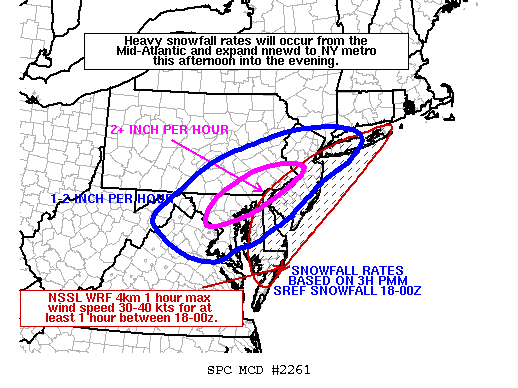
The following post is NOT an official forecast and should not be used as such. It is just the opinion of the poster and may or may not be backed by sound meteorological data. It is NOT endorsed by any professional institution including storm2k.org For Official Information please refer to the NHC and NWS products.
0 likes
Carla/Alicia/Jerry(In The Eye)/Michelle/Charley/Ivan/Dennis/Katrina/Rita/Wilma/Ike/Harvey
Member: National Weather Association
Wx Infinity Forums
http://wxinfinity.com/index.php
Facebook.com/WeatherInfinity
Twitter @WeatherInfinity
Member: National Weather Association
Wx Infinity Forums
http://wxinfinity.com/index.php
Facebook.com/WeatherInfinity
Twitter @WeatherInfinity
- southerngale
- Retired Staff
- Posts: 27419
- Joined: Thu Oct 10, 2002 1:27 am
- Location: Southeast Texas (Beaumont area)
-
- Category 5
- Posts: 2165
- Joined: Fri Oct 19, 2007 4:00 pm
- Location: Fairfax, VA
- Tireman4
- S2K Supporter
- Posts: 5679
- Age: 58
- Joined: Fri Jun 30, 2006 1:08 pm
- Location: Humble, Texas
- Contact:
Wow. Just wow. They postponed the NCAA Division III Football Championship (Yes, they have playoffs in Division III..LOL) in Roanoke until 3 pm CT. Goodness.
Due to heavy snowfall in the Salem and Roanoke, Va. area, the 2009 NCAA Division III Football Championship will now air live on ESPN Classic/ESPN360.com Saturday at 4pm ET.
http://www.ncaa.com/
Due to heavy snowfall in the Salem and Roanoke, Va. area, the 2009 NCAA Division III Football Championship will now air live on ESPN Classic/ESPN360.com Saturday at 4pm ET.
http://www.ncaa.com/
0 likes
-
- Professional-Met
- Posts: 33399
- Joined: Tue Mar 07, 2006 11:57 pm
- Location: Deep South, for the first time!
Re: Mid Atlantic Winter Storm 12/18-12/19
Stephanie wrote:OMG!! There's a "hurricane force wind warning" off shore of Long Island and New England
Hurricane Joaquin brewing, perhaps?
0 likes
-
- Tropical Storm
- Posts: 180
- Joined: Sun Aug 16, 2009 1:06 pm
- Location: Houston, TX > Lubbock, TX > Savannah, GA
- Contact:
Re: Mid Atlantic Winter Storm 12/18-12/19
crazy- no chance, this is a cold core low that will be over VERY cold waters
0 likes
- srainhoutx
- S2K Supporter
- Posts: 6919
- Age: 66
- Joined: Sun Jan 14, 2007 11:34 am
- Location: Haywood County, NC
- Contact:
Re: Mid Atlantic Winter Storm 12/18-12/19
MESOSCALE DISCUSSION 2261
NWS STORM PREDICTION CENTER NORMAN OK
1127 AM CST SAT DEC 19 2009
AREAS AFFECTED...VA...WV...MD...DE...NJ...PA...NY...CT
CONCERNING...BLIZZARD
VALID 191727Z - 192330Z
HEAVY SNOWFALL RATES OF 1-3 INCHES PER HOUR ARE LIKELY FROM THE D.C.
I-95 CORRIDOR NNEWD TOWARDS LONG ISLAND THIS AFTERNOON. WITHIN THIS
ZONE...BLIZZARD-LIKE CONDITIONS WILL LIKELY AFFECT PORTIONS OF THE
MEGALOPOLIS.
CENTER OF MAJOR EAST COAST CYCLONE/BOMB WILL MAKE GRADUAL NNEWD
PROGRESS FROM EAST OF VA CAPES TO SOUTHEAST OF CAPE MAY NJ THROUGH
EVENING WHILE UNDERGOING SUBSTANTIAL DEEPENING. STRONGEST
ASCENT...AND GREATEST HOURLY SNOWFALL RATES...WILL COINCIDE WITH
MOST INTENSE 850-700MB FRONTOGENESIS AND DEEPEST DENDRITE GROWTH
LAYER. LATEST NCEP-SREF GUIDANCE THROUGH 00Z SHOWS THESE DYNAMIC
AND THERMODYNAMIC FEATURES WILL TRANSITION ONLY SLOWLY NWD/NWWD
THROUGH LATE TODAY. BROAD AND QUASI-BANDED HEAVY SNOW FIELD SHOULD
GRADUALLY DECAY ON ITS SWRN FLANK...AND DEVELOP/INTENSIFY AND PIVOT
COUNTERCLOCKWISE FROM NRN MD/SERN PA TO SOUTH SHORE OF LONG ISLAND
THROUGH LATER THIS AFTERNOON.
SREF PROBABILITY MATCHED-MEAN /PMM/ 3-HOUR SNOWFALL TOTALS WERE USED
TO ARRIVE AT THE 1-2 INCH AND 2 INCH PLUS PER HOUR RATES DEPICTED IN
THE MD GRAPHIC. FURTHERMORE...AS BOMBOGENESIS OCCURS OFFSHORE...THE
INCREASING PRESSURE GRADIENT WILL LEAD TO STRONG WINDS AOA 35 MPH
FROM DELMARVA NWD TOWARDS LONG ISLAND. THIS IS SUPPORTED BY THE 00Z
NSSL 4 KM WRF SHOWING MAX 1 HOURLY WINDS BETWEEN 30-40 KTS OVER THIS
CORRIDOR. THUS...CONSIDERABLE FALLING...BLOWING...AND DRIFTING SNOW
WILL RESULT IN BLIZZARD CONDITIONS WITH VISIBILITIES NEAR ZERO IN
THE HEAVIEST SNOW BURSTS.
..SMITH/CARBIN.. 12/19/2009
0 likes
Carla/Alicia/Jerry(In The Eye)/Michelle/Charley/Ivan/Dennis/Katrina/Rita/Wilma/Ike/Harvey
Member: National Weather Association
Wx Infinity Forums
http://wxinfinity.com/index.php
Facebook.com/WeatherInfinity
Twitter @WeatherInfinity
Member: National Weather Association
Wx Infinity Forums
http://wxinfinity.com/index.php
Facebook.com/WeatherInfinity
Twitter @WeatherInfinity
- Dionne
- S2K Supporter
- Posts: 1616
- Age: 73
- Joined: Mon Jan 02, 2006 8:51 am
- Location: SW Mississippi....Alaska transplant via a Southern Belle.
Re: Mid Atlantic Winter Storm 12/18-12/19
Washington National DCA (airport) closed at 11AM EST. BWI reporting a vertical ceiling of 200 feet with ice......and still open?? Wow! JFK....lots of cancellations and numerous inbound flights from Europe. Going to be an interesting evening.
IAH (Houston) now showing gate holds.
Watch as the eastern corridor shuts down and affects travel. Gonna be a long night for some folks.
IAH (Houston) now showing gate holds.
Watch as the eastern corridor shuts down and affects travel. Gonna be a long night for some folks.
0 likes
- Stephanie
- S2K Supporter
- Posts: 23842
- Age: 61
- Joined: Thu Feb 06, 2003 9:53 am
- Location: Glassboro, NJ
Re: Mid Atlantic Winter Storm 12/18-12/19
I'm just on that southern border of 2+ inches per hour. The snow is coming down hard now.
0 likes
Who is online
Users browsing this forum: No registered users and 33 guests