TIMOR SEA : TROPICAL CYCLONE LAURENCE (06S)
Moderator: S2k Moderators

Re: TIMOR SEA : TROPICAL CYCLONE LAURENCE (06S)
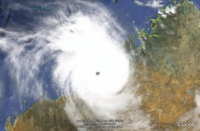
IMO Laurence is already a cat 5 in the Australian scale and cat4 in the Saffir-Simpson scale. It's a very impressive storm.
0 likes


-
cycloneye

- Admin

- Posts: 149275
- Age: 69
- Joined: Thu Oct 10, 2002 10:54 am
- Location: San Juan, Puerto Rico
Re: TIMOR SEA : TROPICAL CYCLONE LAURENCE (06S)
JTWC 0300z Warning=100kts
WTXS33 PGTW 210300
MSGID/GENADMIN/NAVMARFCSTCEN PEARL HARBOR HI/JTWC//
SUBJ/TROPICAL CYCLONE 06S (LAURENCE) WARNING NR 014//
RMKS/
1. TROPICAL CYCLONE 06S (LAURENCE) WARNING NR 014
02 ACTIVE TROPICAL CYCLONES IN SOUTH IO
MAX SUSTAINED WINDS BASED ON ONE-MINUTE AVERAGE
WIND RADII VALID OVER OPEN WATER ONLY
---
WARNING POSITION:
210000Z --- NEAR 19.0S 120.4E
MOVEMENT PAST SIX HOURS - 165 DEGREES AT 03 KTS
POSITION ACCURATE TO WITHIN 060 NM
POSITION BASED ON EYE FIXED BY A COMBINATION OF
SATELLITE AND RADAR
PRESENT WIND DISTRIBUTION:
MAX SUSTAINED WINDS - 100 KT, GUSTS 125 KT
WIND RADII VALID OVER OPEN WATER ONLY
RADIUS OF 064 KT WINDS - 025 NM NORTHEAST QUADRANT
025 NM SOUTHEAST QUADRANT
025 NM SOUTHWEST QUADRANT
025 NM NORTHWEST QUADRANT
RADIUS OF 050 KT WINDS - 040 NM NORTHEAST QUADRANT
045 NM SOUTHEAST QUADRANT
050 NM SOUTHWEST QUADRANT
045 NM NORTHWEST QUADRANT
RADIUS OF 034 KT WINDS - 090 NM NORTHEAST QUADRANT
075 NM SOUTHEAST QUADRANT
075 NM SOUTHWEST QUADRANT
085 NM NORTHWEST QUADRANT
REPEAT POSIT: 19.0S 120.4E
---
FORECASTS:
12 HRS, VALID AT:
211200Z --- 19.8S 120.8E
MAX SUSTAINED WINDS - 085 KT, GUSTS 105 KT
WIND RADII VALID OVER OPEN WATER ONLY
DISSIPATING AS A SIGNIFICANT TROPICAL CYCLONE OVER LAND
RADIUS OF 064 KT WINDS - 020 NM NORTHEAST QUADRANT
015 NM SOUTHEAST QUADRANT
020 NM SOUTHWEST QUADRANT
020 NM NORTHWEST QUADRANT
RADIUS OF 050 KT WINDS - 030 NM NORTHEAST QUADRANT
025 NM SOUTHEAST QUADRANT
035 NM SOUTHWEST QUADRANT
035 NM NORTHWEST QUADRANT
RADIUS OF 034 KT WINDS - 075 NM NORTHEAST QUADRANT
065 NM SOUTHEAST QUADRANT
055 NM SOUTHWEST QUADRANT
070 NM NORTHWEST QUADRANT
VECTOR TO 24 HR POSIT: 145 DEG/ 06 KTS
---
24 HRS, VALID AT:
220000Z --- 20.8S 121.5E
MAX SUSTAINED WINDS - 050 KT, GUSTS 065 KT
WIND RADII VALID OVER OPEN WATER ONLY
DISSIPATING AS A SIGNIFICANT TROPICAL CYCLONE OVER LAND
---
REMARKS:
210300Z POSITION NEAR 19.2S 120.5E.
TROPICAL CYCLONE (TC) 06S (LAURENCE), LOCATED APPROXIMATELY 125 NM
NORTHEAST OF PORT HEDLAND, AUSTRALIA, HAS RECURVED AND TRACKED
SOUTH-SOUTHEASTWARD AT 03 KNOTS OVER THE PAST SIX HOURS. ANIMATED
WATER VAPOR IMAGERY SHOWS THE SYSTEM HAS FURTHER CONSOLIDATED AND
DEEPENED AS IT CONTINUED TO MOVE ACROSS VERY WARM SEA SURFACE
TEMPERATURES. THE CURRENT POSITION IS BASED ON ANIMATED RADAR IMAGERY
FROM BROOME, AUSTRALIA, AND FROM A 202330Z INFRARED IMAGE SHOWING A
15-NM EYE. THE CURRENT INTENSITY IS BASED ON DVORAK ESTIMATES FROM
PGTW AND KNES OF T5.5. UPPER LEVEL ANALYSIS INDICATES THE SYSTEM IS
DIRECTLY UNDERNEATH THE RIDGE AXIS IN AN AREA OF LOW VERTICAL WIND
SHEAR. A MID-LATITUDE TROUGH APPROACHING FROM THE WEST HAS BEGUN
STEERING THE CYCLONE TO THE SOUTH-SOUTHEAST. TC 06S IS EXPECTED TO
ACCELERATE SOUTHEASTWARD AND MAKE LANDFALL BY TAU 12 BEFORE IT
RAPIDLY WEAKENS DUE TO INCREASED VERTICAL WIND SHEAR AND EXPOSURE TO
AUSTRALIA'S RUGGED TERRAIN. THE AVAILABLE NUMERIC GUIDANCE IS IN
OVERALL GOOD AGREEMENT WITH THIS TRACK FORECAST.
MAXIMUM SIGNIFICANT WAVE HEIGHT AT 210000Z IS 22 FEET. NEXT WARNING
AT 211500Z. REFER TO TROPICAL CYCLONE 05S (FIVE) WARNINGS (WTXS32
PGTW) FOR TWELVE-HOURLY UPDATES.//
NNNN
0 likes
Visit the Caribbean-Central America Weather Thread where you can find at first post web cams,radars
and observations from Caribbean basin members Click Here
and observations from Caribbean basin members Click Here
-
Blowme
- Tropical Wave

- Posts: 3
- Age: 52
- Joined: Sun Dec 20, 2009 6:05 pm
- Location: Tom Price Western Australia
Re: TIMOR SEA : TROPICAL CYCLONE LAURENCE (06S)
Hopfully this cyclone loses some grunt prior to reaching Tom Price. I am flying out tomorrow. Can't miss my boys birthday or Christmas know can I. By the way Tom Price is a couple hundred kms s/e of current location.
I don't think that Qantas will fly with 280kph winds. Also the airport will be flooded in.
I don't think that Qantas will fly with 280kph winds. Also the airport will be flooded in.
0 likes
I know you guys love wind but I don't
-
cycloneye
- Admin
- Posts: 149275
- Age: 69
- Joined: Thu Oct 10, 2002 10:54 am
- Location: San Juan, Puerto Rico
Re: TIMOR SEA : TROPICAL CYCLONE LAURENCE (06S)
Blowme wrote:Hopfully this cyclone loses some grunt prior to reaching Tom Price. I am flying out tomorrow. Can't miss my boys birthday or Christmas know can I. By the way Tom Price is a couple hundred kms s/e of current location.
I don't think that Qantas will fly with 280kph winds. Also the airport will be flooded in.
First welcome to storm2k and enjoy all of what we have.If you have any questions dont hesitate to ask.This is a very dangerous cyclone that will cause extensive damage where it makes landfall in the comming hours.Have a safe trip to that area when all is clear as you said,planes dont fly with very strong winds.
0 likes
Visit the Caribbean-Central America Weather Thread where you can find at first post web cams,radars
and observations from Caribbean basin members Click Here
and observations from Caribbean basin members Click Here

-
HURAKAN

- Professional-Met

- Posts: 46084
- Age: 39
- Joined: Thu May 20, 2004 4:34 pm
- Location: Key West, FL
- Contact:
Re: TIMOR SEA : SEVERE TROPICAL CYCLONE LAURENCE (06S)
TOP PRIORITY FOR IMMEDIATE BROADCAST
TROPICAL CYCLONE ADVICE NUMBER 79
Issued at 9:15 am WST on Monday, 21 December 2009
BY THE BUREAU OF METEOROLOGY
TROPICAL CYCLONE WARNING CENTRE PERTH
A Cyclone WARNING continues for coastal areas from Broome to Port Hedland and
adjacent inland areas extending inland to Telfer.
A Cyclone WATCH continues for inland parts of the southwest Kimberley and
eastern Pilbara, extending a long way inland to the WA border and including
Warburton and Giles.
At 8:00 am WST Severe Tropical Cyclone Laurence was estimated to be
90 kilometres north northwest of Wallal and
220 kilometres west southwest of Broome
moving south at 6 kilometres per hour.
Severe Tropical Cyclone Laurence is moving southwards towards the Eighty Mile
Beach area of the Pilbara-Kimberley coast. Residents are warned of a period of
VERY DESTRUCTIVE winds with gusts to 260 kilometres per hour developing late
this morning or early this afternoon. People in the area are specifically warned
of the VERY DANGEROUS STORM TIDE expected as the cyclone centre approaches the
coast. Tides are likely to rise significantly above the normal high tide mark
with DAMAGING WAVES and DANGEROUS FLOODING.
GALES are beginning along the coast between Bidyadanga and Wallal and gales and
DESTRUCTIVE winds are likely to extend further along the coast and inland during
the day, possibly reaching as far as Telfer by Tuesday morning.
Heavy rainfall is expected in coastal parts of the western Kimberley and eastern
Pilbara during Monday, extending to the inland eastern Pilbara on Tuesday.
FESA-State Emergency Service advises as a precautionary measure the following
community alerts:
RED ALERT: People in or near communities from Sandfire to Pardoo and inland to
Yarrie need to go to shelter immediately.
YELLOW ALERT: People in Bidyadanga need to take action and get ready to shelter
from a cyclone.
BLUE ALERT: People in or near communities from De Grey to Port Hedland and
inland to Marble Bar, need to prepare for the possibility of a period cyclonic
weather.
Communities in the southwest Kimberley and eastern Pilbara should listen for the
next advice.
Details of Severe Tropical Cyclone Laurence at 8:00 am WST:
.Centre located near...... 19.0 degrees South 120.4 degrees East
.Location accuracy........ within 20 kilometres
.Recent movement.......... towards the south at 6 kilometres per hour
.Wind gusts near centre... 260 kilometres per hour
.Severity category........ 4
.Central pressure......... 939 hectoPascals
The next advice will be issued by 12:00 pm WST Monday 21 December.Cyclone
advices and State Emergency Service Community Alerts are available by
dialling 1300 659 210
A map showing the track of the cyclone is available at:
http://www.bom.gov.au/weather/cyclone
0 likes

-
Squarethecircle
- Category 5

- Posts: 2165
- Joined: Fri Oct 19, 2007 4:00 pm
- Location: Fairfax, VA
-
HURAKAN
- Professional-Met
- Posts: 46084
- Age: 39
- Joined: Thu May 20, 2004 4:34 pm
- Location: Key West, FL
- Contact:
TROPICAL CYCLONE ADVICE NUMBER 80
Issued at 11:45 am WST on Monday, 21 December 2009
BY THE BUREAU OF METEOROLOGY
TROPICAL CYCLONE WARNING CENTRE PERTH
A Cyclone WARNING continues for coastal areas from Bidyadanga to Port Hedland
and adjacent inland areas including Marble Bar, Nullagine and Telfer.
A Cyclone WATCH continues for inland parts of the southwest Kimberley and
eastern Pilbara, extending a long way inland to the WA border and including
Warburton and Giles.
The Cyclone WARNING for Broome to Bidyadanga has been cancelled.
At 11:00 am WST Severe Tropical Cyclone Laurence was estimated to be
75 kilometres north of Wallal and
240 kilometres east northeast of Port Hedland
moving south southeast at 6 kilometres per hour.
Severe Tropical Cyclone Laurence is intensifying as it moves southwards towards
the Eighty Mile Beach area of the Pilbara-Kimberley coast. Residents are warned
of a period of VERY DESTRUCTIVE winds with gusts to 285 kilometres per hour
developing during this afternoon. People in the area are specifically warned of
the VERY DANGEROUS STORM TIDE expected as the cyclone centre approaches the
coast. Tides may rise significantly above the normal high tide mark with
DAMAGING WAVES and DANGEROUS FLOODING.
GALES are beginning along the coast between Bidyadanga and Wallal and gales and
DESTRUCTIVE winds are likely to extend further along the coast and inland during
the day, possibly reaching as far as Telfer by Tuesday morning.
Heavy rainfall is expected in coastal parts of the western Kimberley and eastern
Pilbara today, extending to the inland eastern Pilbara on Tuesday.
FESA-State Emergency Service advises as a precautionary measure the following
community alerts:
RED ALERT: People in or near communities from Sandfire to Pardoo and inland to
Yarrie need to go to shelter immediately.
YELLOW ALERT: People in Bidyadanga need to take action and get ready to shelter
from a cyclone.
BLUE ALERT: People in or near communities from De Grey to Port Hedland and
inland to Marble Bar, Nullagine and Telfer need to prepare for cyclonic weather.
Communities in the southwest Kimberley and eastern Pilbara should listen for the
next advice.
Details of Severe Tropical Cyclone Laurence at 11:00 am WST:
.Centre located near...... 19.1 degrees South 120.5 degrees East
.Location accuracy........ within 20 kilometres
.Recent movement.......... towards the south southeast at 6 kilometres per hour
.Wind gusts near centre... 285 kilometres per hour
.Severity category........ 5
.Central pressure......... 929 hectoPascals
The next advice will be issued by 3:00 pm WST Monday 21 December.Cyclone advices
and State Emergency Service Community Alerts are available by
dialling 1300 659 210
A map showing the track of the cyclone is available at:
http://www.bom.gov.au/weather/cyclone
0 likes
-
HURAKAN
- Professional-Met
- Posts: 46084
- Age: 39
- Joined: Thu May 20, 2004 4:34 pm
- Location: Key West, FL
- Contact:
Re: TIMOR SEA : SEVERE TROPICAL CYCLONE LAURENCE (06S)
UW - CIMSS
ADVANCED DVORAK TECHNIQUE
ADT-Version 8.1.1
Tropical Cyclone Intensity Algorithm
----- Current Analysis -----
Date : 21 DEC 2009 Time : 023000 UTC
Lat : 19:13:00 S Lon : 120:32:10 E
CI# /Pressure/ Vmax
6.0 / 928.5mb/115.0kt
Final T# Adj T# Raw T#
6.0 6.7 7.0
Latitude bias adjustment to MSLP : +1.5mb
Estimated radius of max. wind based on IR : 10 km
Center Temp : -21.7C Cloud Region Temp : -80.1C
Scene Type : EYE
Positioning Method : RING/SPIRAL COMBINATION
Ocean Basin : INDIAN
Dvorak CI > MSLP Conversion Used : PACIFIC
Tno/CI Rules : Constraint Limits : 1.7T/6hr
Weakening Flag : OFF
Rapid Dissipation Flag : OFF
0 likes
-
CrazyC83
- Professional-Met
- Posts: 34315
- Joined: Tue Mar 07, 2006 11:57 pm
- Location: Deep South, for the first time!
Current Intensity Analysis
UW - CIMSS
ADVANCED DVORAK TECHNIQUE
ADT-Version 8.1.1
Tropical Cyclone Intensity Algorithm
----- Current Analysis -----
Date : 21 DEC 2009 Time : 033000 UTC
Lat : 19:11:00 S Lon : 120:27:49 E
CI# /Pressure/ Vmax
6.3 / 920.7mb/122.2kt
Final T# Adj T# Raw T#
6.3 7.0 7.1
Latitude bias adjustment to MSLP : +1.5mb
Estimated radius of max. wind based on IR :N/A km
Center Temp : -18.6C Cloud Region Temp : -81.2C
Scene Type : EYE
Positioning Method : SPIRAL ANALYSIS
Ocean Basin : INDIAN
Dvorak CI > MSLP Conversion Used : PACIFIC
Tno/CI Rules : Constraint Limits : 2.7T/12hr
Weakening Flag : OFF
Rapid Dissipation Flag : OFF
0 likes

-
Crostorm

- Category 5
- Posts: 2060
- Age: 51
- Joined: Mon Dec 25, 2006 3:51 pm
- Location: Croatia-Europe
- Contact:
Re: TIMOR SEA : SEVERE TROPICAL CYCLONE LAURENCE (06S)
It its going for Mandora http://www.bom.gov.au/products/IDR162.loop.shtml
0 likes
-
Crostorm
- Category 5
- Posts: 2060
- Age: 51
- Joined: Mon Dec 25, 2006 3:51 pm
- Location: Croatia-Europe
- Contact:
Re: TIMOR SEA : SEVERE TROPICAL CYCLONE LAURENCE (06S)
UW - CIMSS
ADVANCED DVORAK TECHNIQUE
ADT-Version 8.1.1
Tropical Cyclone Intensity Algorithm
----- Current Analysis -----
Date : 21 DEC 2009 Time : 043000 UTC
Lat : 19:15:00 S Lon : 120:29:49 E
CI# /Pressure/ Vmax
6.8 / 905.9mb/134.8kt
Final T# Adj T# Raw T#
6.8 7.1 7.3
Latitude bias adjustment to MSLP : +1.5mb
Estimated radius of max. wind based on IR : 13 km
Center Temp : -14.9C Cloud Region Temp : -81.9C
Scene Type : EYE
Positioning Method : SPIRAL ANALYSIS
Ocean Basin : INDIAN
Dvorak CI > MSLP Conversion Used : PACIFIC
Tno/CI Rules : Constraint Limits : 2.7T/12hr
Weakening Flag : OFF
Rapid Dissipation Flag : OFF
0 likes
Who is online
Users browsing this forum: No registered users and 50 guests